Debunked: Plumes erupt from New Madrid Seismic Zone =2.9M quake follows. more coming?

I thought the following vid should go in the plumage thread because at the 1:30 mark in the vid he says "Now to the Southwest we have a large steaming event occurring each day, producing enough energy to provide a LOT of hail, damaging winds each day and they die out roughly nine, ten o'clock in the evening as we're seeing today...but that's a lot of energy to tap into for this low pressure system up here to the Northwest."

Daily convective cells in the Southwest you say? Yeah, it's called monsoon season.

7/24/2012 -- Snow and Sleet north of Idaho -- NE SE N SW and W = hail / damaging winds

Where to even start with this guy, he's so full of it.
That low he mentioned is centered near Calgary Canada, where Inellicast auto-detected frozen precip of some kind. Even if snow or sleet actually did occur, it was in higher elevations outside of Calgary in the Canadian Rockies. Not at all unusual to get snow in the Canadian Rockies in the middle of summer. Heck, we often get snow on the higher peaks of the Cascades in the middle of summer here in Oregon, hundreds of miles south of Calgary.

He makes me nauseous, I can't go on...every word out of his mouth is just ludicrous. How brain dead do you have to be to believe this charlatan?

cheers
 
I'm posting dutch's latest Sakurajima vid as another example of how inaccurate he is and how little he knows, even though he basically claims to be some sort of self-made expert. I also think he's trying to hype/prove/fearmonger his 'steam plumes from dormant volcanoes leading to imminent eruptions' bs by using one of the most active volcanoes in the world as an example. Of course the activity of Sakurajima's steam vents and dutch's "steam plumes" are nothing alike.

7/25/2012 -- NEW CALDERA EXPLODES! Large Shock Wave -- Sakurajima Volcano in Japan

His description of the video:

A NEW CALDERA HAS FORMED !!! behind the common erupting caldera.. on the back side of the mountain... a new area has exploded ! It began steaming MONTHS ago.. October 2011. 桜島の噴火によるキノコ雲

Better put.. a dormant caldera has re-awakened.. per the japanese agency which monitors this volcano.. its has been a few years since this portion of the volcano has shown any kind of eruption.

That eruption actually came from the Minami-dake crater Anyone who claims to know a thing or two about geology should know the difference between a crater and a caldera. Besides, a new crater wasn't formed anyway, it was just an explosive eruption from an existing crater.

Definition of Caldera:

A caldera is a cauldron-like volcanic feature usually formed by the collapse of land following a volcanic eruption. They are sometimes confused with volcanic craters.

Besides, Minami-dake crater wasn't dormant, it just hasn't been as active recently as the crater right next to it. A few years of less activity is far from "dormant".

More info on Sakurajima:

http://www.photovolcanica.com/VolcanoInfo/Sakurajima/Sakurajima.html

Some details on the latest eruption:

http://www.volcanodiscovery.com/sak...-and-more-than-usual-frequent-explosions.html
 
Here's another vid of his where he tries to twist unrelated common events into some kind of evidence that his steam plume idea is right.

8/9/2012 -- Military Movement to Hawthorne Walker Lake - Earthquake at Hawthorne Walker Lake

Dutch's vid was instigated by another vid filmed in Nevada of the 100th Quartermaster Water Purification and Distribution Company on their way to Walker Lake to purify some water.

It's a Convoy!

Near Walker Lake is a military munitions depot at Hawthorne, NV. There was a small 2.6 earthquake 8 miles ESE of Hawthorne, which puts it about 15 miles SE of the lake. There were around 5 small eq's in NV on Aug. 8 spread along the vicinity of the border with CA, btw. The NV CA border experiences small eq's pretty much every day. So dutch takes a routine convoy on it's way to fill a water buffalo or two with purified water from a lake, and a tiny earthquake that happens to occur within a few miles of the lake in tectonically active region and weaves it into some kind of conspiracy to which he declared in his video's description...

We got big time problems.

This video.. from Nevada .. Shot August 8, 2012.. http://www.youtube.com/watch?v=-YZI6Fs_MbA

Shows heavy troop movement .. by the own words heading to Hawthorne / Walker Lake Nevada... something to do with "water levels being low".

Move forward several hours.. and we see a 2.7M earthquake at Hawthorne / Walker Lake: Link to screenshots and EQ stats here: http://sincedutch.wordpress.com/2012/08/09/892012-earthquake-near-the-hawthor...

If you scroll back through my public facebook... http://www.facebook.com/pages/Dutchsinse/296574443728320?ref=hl

look at the posts from yesterday August 8, 2012 .. I made a specific post about the STEAM PLUMES erupting SOUTH OF MONO LAKE OUT OF NEVADA !!

I believe these large steam plumes to be coming from deep earth aquifer rapid steam off / depletion due to heating in shallower areas from either magma rising or an accelerating plate subduction process ..

I said this in the post on facebook..

"Dutchsinse
5 hours ago
wow... south of mono lake california.. im thinking the steam plume activity in mexico and the sw USA is indeed related to the subduction occurring..

makes sense to me (IMO).. as the plate is pushed underneath from the west.. the steam is rising at weaker points .. steam could be coming from the interaction of the craton and subduction zones to the SW and W ..

http://climate.cod.edu/flanis/1km.php?loop=1&type=vis&region=Nevada&a...
2Like · · Share Melody Perschon, Keith Breshears and 20 others like this."
------

Same time the plumes are erupting.. afternoon on the 8th of August (2012) ..now we see military movement in a major fashion going to "check on water levels" just north of the plume area.... meanwhile just south a steam plume that is MASSIVE by all standards was coming out about 80 miles south of Hawthorne.


Then........ to top it off.... an earthquake hits the area the military was traveling to.

I mean, you can't make this stuff up folks.

"Shows heavy troop movement .. by the own words heading to Hawthorne / Walker Lake Nevada... something to do with "water levels being low"."

Here dutch just flat out lies. Anyone watching the original video can see it's a smallish convoy and nothing close to what any sane person would consider "heavy troop movement". The soldier that spoke to the guy filming them said they were just going up to Hawthorne, Walker lake to purify some water and went on to comment about what a smart move it is to have a water purification unit (meaning his army unit) in the state of Nevada. No mention at all of water levels or anything else about the lake. The equipment they were hauling would fit his description of their mission.

Of course his plume's have been thoroughly debunked in and throughout this thread, including the ones near Mono Lake, Nevada.

Anyway, here's the comment I left on dutch's vid:

The unit was identified as the 100th Quartermasters. It's actually the 100th Quartermaster Water Purification and Distribution Company, under the 17th Sustainment Brigade of the Nevada National Guard. The soldier who spoke in the vid said they were going to Walker to purify some water, no surprise there, that's what they do. When I was in the Reserves, during our annual two week field maneuvers all our potable water was supplied by a Quartermaster company. Nothing unusual about this at all.
timsolrey 1 hour ago in playlist

cheers
 
http://www.youtube.com/watch?v=3CLLIcV3QC8&list=UUHE92x768p8h-fMrqhsnE1Q&index=1&feature=plcp

He claims that diurnal convection over the desert near the northern Sea of Cortez must be volcanic plumes because there are no fronts in the area and the area is desert. One of the plumes does occur over a volcanic formation. But the others do not.

But, the "plumes" look extactly like diurnal thunderstorms that form along a seabreeze front. In the satellite loops you can sea the breeze push in off of the sea as a diurnal field off cumulus clouds forms around the perimeter of the sea. Typical of the summer season the land gets hotter than the sea during the days so air rises over the land and subsides over the sea. That cause clear skies over the water and a breeze to blow toward land like a little mini-cool front. That little front often provides enough lift to an already buoyant air parcel to trigger a thunderstorm. That is what happens in this video.

If my interpretation of the satellite imagery is incorrect and Dutch is correct, he should be able to easily verify and eruption of sorts via a ground truthing visit to the site of the "plumes".

Also, diurnal thunderstorms are exactly the type of weather expected this time of year there:
The amount and seasonality of rainfall are defining characteristics of the Sonoran Desert. Much of the area has a biseasonal rainfall pattern, though even during the rainy seasons most days are sunny. From December to March frontal storms from North Pacific Ocean occasionally bring widespread, gentle rain to the northwestern areas. From July to mid-September, the summer monsoon brings surges of wet tropical air and frequent but localized violent thunderstorms...[/QUOTE]

http://www.desertmuseum.org/desert/sonora.php

I posted the blurb from desertmuseum.org into the comments in the video. .

 
http://www.youtube.com/watch?v=3CLLIcV3QC8&list=UUHE92x768p8h-fMrqhsnE1Q&index=1&feature=plcp

He claims that diurnal convection over the desert near the northern Sea of Cortez must be volcanic plumes because there are no fronts in the area and the area is desert. One of the plumes does occur over a volcanic formation. But the others do not.

But, the "plumes" look extactly like diurnal thunderstorms that form along a seabreeze front. In the satellite loops you can sea the breeze push in off of the sea as a diurnal field off cumulus clouds forms around the perimeter of the sea. Typical of the summer season the land gets hotter than the sea during the days so air rises over the land and subsides over the sea. That cause clear skies over the water and a breeze to blow toward land like a little mini-cool front. That little front often provides enough lift to an already buoyant air parcel to trigger a thunderstorm. That is what happens in this video.

If my interpretation of the satellite imagery is incorrect and Dutch is correct, he should be able to easily verify and eruption of sorts via a ground truthing visit to the site of the "plumes".

Also, diurnal thunderstorms are exactly the type of weather expected this time of year there:
The amount and seasonality of rainfall are defining characteristics of the Sonoran Desert. Much of the area has a biseasonal rainfall pattern, though even during the rainy seasons most days are sunny. From December to March frontal storms from North Pacific Ocean occasionally bring widespread, gentle rain to the northwestern areas. From July to mid-September, the summer monsoon brings surges of wet tropical air and frequent but localized violent thunderstorms...

http://www.desertmuseum.org/desert/sonora.php

I posted the blurb from desertmuseum.org into the comments in the video. .


Here is a video from another person, who apparently talked to Dutch about it...

http://www.youtube.com/watch?v=S407AwijOcc&feature=player_embedded

First, he thinks what he is looking at is infrared...

and he thinks that those are heat signatures...

and the percussion waves are from explosions...

when it really is just a thunderstorm producing a gust front/ outflow boundary.
 
His latest plume of doom vid:

10/17/2012 -- Plumes erupt from Pinacate Volcano -- just South of Arizona

He ignores the other similar radar returns and just focuses on what happens to occur in the general vicinity of the Pinacate Volcanic Field. One fact about the Pinacate field that dutch hasn't mentioned and apparently is not aware of, there are "hydro-volcanoes" created by steam explosions when hot magma interacted with ground water. However that's not what's seen on radar in this latest vid, or any of his other "plume" vids.

After reviewing various weather maps and the satellite view those radar returns dutch claims are steam plumes are nothing more than orographic induced showers and/or virga as a moist tropical airmass moved over the mountains in the Sonoran Desert SSE of Yuma, AZ along the northern edge of circulation around tropical depression Paul. Anti-cyclonic upper level outflow bands from TD Paul can be seen on satellite over the Sonoran Desert which would produce some shear and instability over the mountains. Given the conditions it's no surprise to see some orographic action in that area.

Just as another example that dutch doesn't know what he's talking about, in the following vid about a recent earthquake in Maine, he identifies the location as near the border of Maine and Massachusettes. As one commenter points out, ME and MA do not share a border, a section of New Hampshire lies between ME and MA along the coast.

http://www.youtube.com/watch?v=x67XB-dz-A8

cheers
 
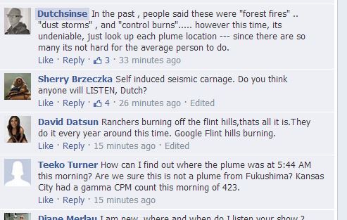
It is burn season again in the south. Lots of wildfires and prescribed fires under the dry high pressure yesterday. He is pushing his plume bunk again.

From his facebook page:

Dutchsinse they all erupt at the same time -- can't really be wildfires.. since they all come up at once..

if its control burns.. its well timed across 10 states...

In my personal opinion.. they could be fires caused by underground activity.. that might explain why they're gone by the AM each time they happen.

Seems to be in a cycle too.. we did NOT see any kind of large fire smoke plumes over the summer (in the 100F+ heat).. but we see it each year at this time.

Im leaning towards geologic cycle as the cause. Underground heating of the shale maybe?

Again, to have these all pop up at once.. and be gone by the AM the next day.. this is like yellowstone over a large area..

Like daily geyser activity.. notice the time these erupt.. compare to yellowstones activity for instance.. you see they match perfectly!

Not saying this is going to erupt, but saying the timing is something we cannot overlook

He is mystified by the timing. Control burns and wildfires alike peak in intensity during the relative humidity minimum and diurnal mixing peak in the early to mid afternoon so that is when they are visible on satellite imagery.

He also noticed the seasonal pattern. What he is ignoring is that daily fire activity is summarized at:
http://gacc.nifc.gov/sacc/predictive/intelligence/SACCMorningReport.pdf

There are also burn plans available from the national forests and state agencies that are doing burns.

He was supplied all the nessecary to locate the fires last year so he should know that these are fires. Fire behavior was explained to him as well.

What he observed yesterday was exactly the same as when it was sunny and dry last March.
 
Again, to have these all pop up at once.. and be gone by the AM the next day.. this is like yellowstone over a large area..

Like daily geyser activity.. notice the time these erupt.. compare to yellowstones activity for instance.. you see they match perfectly!

What? Who is he trying to fool? There are dozens of geysers across three basins in Yellowstone and they're all on different eruption cycles, many of them quite sporadic, making for ongoing activity day and night. Here's a sample:

http://www.nps.gov/yell/naturescience/geyseractivity.htm


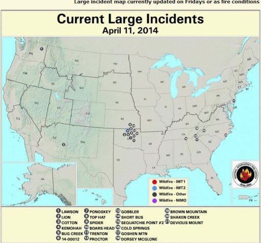
Look at all the prescribed fire activity scheduled for today, Fri. March 8:

Prescribed Fire Activity: State or Federal lands – 257 Prescribe Fires for 43,746 acres in AL, AR, FL, LA, NC, SC, TX

if its control burns.. its well timed across 10 states...

There is a certain procedure, yes indeed... CONTROL, that's the idea.
 
if its control burns.. its well timed across 10 states...

I explained the timing to him last year before he blocked me from his channel and deleted and disabled comments on the plume vids that spawned this thread.

The timing is not due to coordination between agencies. It is due to resource managers conducting burns under specific conditions.

Foresters are trying to time the seasonality of the fire to be most beneficial to forest ecology and that mimic natural fire as best as possible without going out of control. That means that an entire region will want fires at similar times in similar habitats. Therefore you will see burning in forests from the peninsula of Florida all the way out to the Ouachita National Forest in easter OK and western AR at a similar time of year. This is that time of year.

The next ingredient is weather. The fire must burn effectively but not explosively. The forester also wants the smoke to disperse. So it needs to be dry but not too dry and dispersion indices need to be good but without crazy strong wind. Relative humidity of 25-35% for a few hours during the warmest part of the day is desirable. These conditions generally occur at the same time over a wide region in association with high pressure systems. That means foresters over a huge area are likely to due their planned burns on the same day and this is what we see.

Plus it is natural fire behavior for the fire to peak in intensity during the afternoon when relative humidity is lowest and mixing and dispersion are the best. Burning is best down when there is a big diurnal swing in temperature such as under high pressure when lots of sun warms the day and radiational cooling makes for cool calm stable nights. Then at night when the winds calm and the relative humidity increases (because the air gets cooler while the amount of moisture in the air stays the same) the fire lays down. This occurs whether the fire was deliberately set or is an ongoing wild fire.

There are no geothermal processes with a diurnal or seasonal signal such as the smoke that he is seeing on visible satellite.

Plus, when he insists that it is "steam" as from a geyser, the natural question is why is it only visible in daylight on satellite images taken in the visible spectrum and not on water vapor imagery. But we don't even need to go that far in questioning to know that he is incorrect. The fires are documented. People that live in those areas see and smell the smoke...
 
Ouachita National Forest - Prescribed Fire Information FY-13
[FONT=Arial,Arial Narrow][FONT=Arial,Arial Narrow]Date [/FONT][/FONT]
[FONT=Arial,Arial Narrow][FONT=Arial,Arial Narrow]Ranger District [/FONT][/FONT]
[FONT=Arial,Arial Narrow][FONT=Arial,Arial Narrow]County [/FONT][/FONT]
[FONT=Arial,Arial Narrow][FONT=Arial,Arial Narrow]Burn Name / Location [/FONT][/FONT]
[FONT=Arial,Arial Narrow][FONT=Arial,Arial Narrow]Legal [/FONT][/FONT]
[FONT=Arial,Arial Narrow][FONT=Arial,Arial Narrow]Long Lat [/FONT][/FONT]
[FONT=Arial,Arial Narrow][FONT=Arial,Arial Narrow]Planned Acres [/FONT][/FONT]
[FONT=Arial,Arial Narrow][FONT=Arial,Arial Narrow]Actual Acres [/FONT][/FONT]
[FONT=Arial,Arial Narrow][FONT=Arial,Arial Narrow]3/8 [/FONT][/FONT]
[FONT=Arial,Arial Narrow][FONT=Arial,Arial Narrow]Caddo / Womble [/FONT][/FONT]
[FONT=Arial,Arial Narrow][FONT=Arial,Arial Narrow]Montgomery [/FONT][/FONT]
[FONT=Calibri,Calibri][FONT=Calibri,Calibri]Lick Mountain / #15 W89 / 2 miles NE of Big Fork, AR [/FONT][/FONT]
[FONT=Arial,Arial Narrow][FONT=Arial,Arial Narrow]T3S R27W S16-22, 29-30
T3S R28W S24
[/FONT]
[/FONT]
[FONT=Arial,Arial Narrow][FONT=Arial,Arial Narrow]34 28 17
93 54 51
[/FONT]
[/FONT]
[FONT=Arial,Arial Narrow][FONT=Arial,Arial Narrow]3,411 [/FONT][/FONT]
[FONT=Arial,Arial Narrow][FONT=Arial,Arial Narrow]3/8 [/FONT][/FONT]
[FONT=Arial,Arial Narrow][FONT=Arial,Arial Narrow]Jessieville/Winona/ Fourche [/FONT][/FONT]
[FONT=Arial,Arial Narrow][FONT=Arial,Arial Narrow]Perry [/FONT][/FONT]
[FONT=Calibri,Calibri][FONT=Calibri,Calibri]North Link Mtn / Aplin [/FONT][/FONT]
[FONT=Arial,Arial Narrow][FONT=Arial,Arial Narrow]T3N R19W S8-11, 14-17 [/FONT][/FONT]
[FONT=Arial,Arial Narrow][FONT=Arial,Arial Narrow]34.91639
93.03383
[/FONT]
[/FONT]
[FONT=Arial,Arial Narrow][FONT=Arial,Arial Narrow]3,104 [/FONT][/FONT]
[FONT=Arial,Arial Narrow][FONT=Arial,Arial Narrow]3/8 [/FONT][/FONT]
[FONT=Arial,Arial Narrow][FONT=Arial,Arial Narrow]Mena / Oden [/FONT][/FONT]
[FONT=Arial,Arial Narrow][FONT=Arial,Arial Narrow]Scott [/FONT][/FONT]
[FONT=Calibri,Calibri][FONT=Calibri,Calibri]Johnson Creek # 1 / Y-City [/FONT][/FONT]
[FONT=Arial,Arial Narrow][FONT=Arial,Arial Narrow]T1N R30W S20-22, 27-30 [/FONT][/FONT]
[FONT=Arial,Arial Narrow][FONT=Arial,Arial Narrow]34 43 33
94 11 33
[/FONT]
[/FONT]
[FONT=Arial,Arial Narrow][FONT=Arial,Arial Narrow]1,646 [/FONT][/FONT]
[FONT=Arial,Arial Narrow][FONT=Arial,Arial Narrow]3/8 [/FONT][/FONT]
[FONT=Arial,Arial Narrow][FONT=Arial,Arial Narrow]Poteau / Cold Springs [/FONT][/FONT]
[FONT=Arial,Arial Narrow][FONT=Arial,Arial Narrow]Scott [/FONT][/FONT]
[FONT=Calibri,Calibri][FONT=Calibri,Calibri]Buffalo 5 / Buffalo Mtn [/FONT][/FONT]
[FONT=Arial,Arial Narrow][FONT=Arial,Arial Narrow]T2N R29W S29-32 [/FONT][/FONT]
[FONT=Arial,Arial Narrow][FONT=Arial,Arial Narrow]34 48 00
94 06 54
[/FONT]
[/FONT]
[FONT=Arial,Arial Narrow][FONT=Arial,Arial Narrow]584 [/FONT][/FONT]
[FONT=Arial,Arial Narrow][FONT=Arial,Arial Narrow]3/8 [/FONT][/FONT]
[FONT=Arial,Arial Narrow][FONT=Arial,Arial Narrow]Poteau / Cold Springs [/FONT][/FONT]
[FONT=Arial,Arial Narrow][FONT=Arial,Arial Narrow]Scott [/FONT][/FONT]
[FONT=Calibri,Calibri][FONT=Calibri,Calibri]White Oak 2 / White Oak Mtn [/FONT][/FONT]
[FONT=Arial,Arial Narrow][FONT=Arial,Arial Narrow]T4N R28W S34-36
T4N R27W S31-32
T3N R28W S1-3
T3N R27W S5-6
[/FONT]
[/FONT]
[FONT=Arial,Arial Narrow][FONT=Arial,Arial Narrow]34 57 10
93 55 30
[/FONT]
[/FONT]
[FONT=Arial,Arial Narrow][FONT=Arial,Arial Narrow]3,334 [/FONT][/FONT]
[FONT=Arial,Arial Narrow][FONT=Arial,Arial Narrow]3/7 [/FONT][/FONT]
[FONT=Arial,Arial Narrow][FONT=Arial,Arial Narrow]Jessieville/Winona/ Fourche [/FONT][/FONT]
[FONT=Arial,Arial Narrow][FONT=Arial,Arial Narrow]Garland [/FONT][/FONT]
[FONT=Calibri,Calibri][FONT=Calibri,Calibri]Jessieville / Jessieville [/FONT][/FONT]
[FONT=Arial,Arial Narrow][FONT=Arial,Arial Narrow]T1N R19W S30 [/FONT][/FONT]
[FONT=Arial,Arial Narrow][FONT=Arial,Arial Narrow]34 42 22
93 03 57
[/FONT]
[/FONT]
[FONT=Arial,Arial Narrow][FONT=Arial,Arial Narrow]15 [/FONT][/FONT]
[FONT=Arial,Arial Narrow][FONT=Arial,Arial Narrow]5 [/FONT][/FONT]
[FONT=Arial,Arial Narrow][FONT=Arial,Arial Narrow]3/7 [/FONT][/FONT]
[FONT=Arial,Arial Narrow][FONT=Arial,Arial Narrow]Oklahoma [/FONT][/FONT]
[FONT=Arial,Arial Narrow][FONT=Arial,Arial Narrow]LeFlore [/FONT][/FONT]
[FONT=Calibri,Calibri][FONT=Calibri,Calibri]Walk-in Turkey Area / Post Mountain [/FONT][/FONT]
[FONT=Arial,Arial Narrow][FONT=Arial,Arial Narrow]T4N R24E S30 [/FONT][/FONT]
[FONT=Arial,Arial Narrow][FONT=Arial,Arial Narrow]34 47 45
94 42 29
[/FONT]
[/FONT]
[FONT=Arial,Arial Narrow][FONT=Arial,Arial Narrow]163 [/FONT][/FONT]
[FONT=Arial,Arial Narrow][FONT=Arial,Arial Narrow]163 [/FONT][/FONT]
[FONT=Arial,Arial Narrow][FONT=Arial,Arial Narrow]3/7 [/FONT][/FONT]
[FONT=Arial,Arial Narrow][FONT=Arial,Arial Narrow]Mena / Oden [/FONT][/FONT]
[FONT=Arial,Arial Narrow][FONT=Arial,Arial Narrow]Yell [/FONT][/FONT]
[FONT=Calibri,Calibri][FONT=Calibri,Calibri]Chula 1 / Chula [/FONT][/FONT]
[FONT=Arial,Arial Narrow][FONT=Arial,Arial Narrow]T1N R25W S1-4, 9-11
T2N R25W S33-36
[/FONT]
[/FONT]
[FONT=Arial,Arial Narrow][FONT=Arial,Arial Narrow]34 45 9.5
93 39 59.863
[/FONT]
[/FONT]
[FONT=Arial,Arial Narrow][FONT=Arial,Arial Narrow]2,500 [/FONT][/FONT]
[FONT=Arial,Arial Narrow][FONT=Arial,Arial Narrow]2,500 [/FONT][/FONT]
[FONT=Arial,Arial Narrow][FONT=Arial,Arial Narrow]3/7 [/FONT][/FONT]
[FONT=Arial,Arial Narrow][FONT=Arial,Arial Narrow]Jessieville/Winona/ Fourche [/FONT][/FONT]
[FONT=Arial,Arial Narrow][FONT=Arial,Arial Narrow]Montgomery [/FONT][/FONT]
[FONT=Calibri,Calibri][FONT=Calibri,Calibri]Comp 615 / Fannie [/FONT][/FONT]
[FONT=Arial,Arial Narrow][FONT=Arial,Arial Narrow]T1S R23W S13,14,23,24
T1S R22W S19
[/FONT]
[/FONT]
[FONT=Arial,Arial Narrow][FONT=Arial,Arial Narrow]34 38 13
93 24 48
[/FONT]
[/FONT]
[FONT=Arial,Arial Narrow][FONT=Arial,Arial Narrow]2,075 [/FONT][/FONT]
[FONT=Arial,Arial Narrow][FONT=Arial,Arial Narrow]2,075 [/FONT][/FONT]
 
http://www.fs.usda.gov/Internet/FSE_DOCUMENTS/stelprdb5408472.pdf

http://www.fs.usda.gov/Internet/FSE_DOCUMENTS/stelprdb5369128.pdf

That's just the activity from two national forests. It's a busy time for foresters.

Incidentally, Ozark-St. Francis is plenty close to Dutch for him to go ground-truth his claims but he doesn't for some reason. If I was seeing a geologic event that I thought foretold an impending mega-event and not one meteorologists or geologist noticed I'd be all over that massive discovery. He's gone on plenty of other "investigative" field trips.
 
He has now made a plume youtube video.

http://www.youtube.com/watch?v=OjemqiZx7FI

http://www.youtube.com/watch?v=ODXwM_01afw

Published on Mar 8, 2013
WATCH VIDEO IN HD!

thanks to Luca Milevoj !!

satellite image :
http://i.imgur.com/pwYHJjO.jpg

http://climate.cod.edu/flanis/satelli...

larger view here:

http://climate.cod.edu/flanis/satelli...

Looks like the entire edge of the craton is burning. Can't be wildfires (too well timed) .. and control burns across millions of acres all at once? hmm. could be possible, but unlikely over that large of an area / that many states.

Something up. Draw your own conclusions.

No exaggeration .. literally.. All at once across millions of acres -- Entire state of Georgia, reaching west across Alabama, and Mississippi.. south to Florida .. north to South / North Carolina.


I attempted to respond to his claims via comments on youtube. I am recording my responses here for posterity in case he deletes the comments, blocks me, and then mis-represents my comments as he did last year.


scombrid2 1 second ago
It is controlled burns and it isn't covering millions of acres, but there are hundred of them.
Southern Area Incident Management Report from the Southern Area Coordination Center (agency that coordinates fire fighting and monitoring among local, state, and federal agencies) says for yesterday:
""""""Prescribed Fire Activity:
State or Federal lands

257
Prescribe Fires for
43,746 acres in
AL, AR, FL, LA, NC, SC, TX"""""

·


Now on video. A 2 part series no less.

http://www.youtube.com/watch?v=ODXwM_01afw

http://www.youtube.com/watch?v=OjemqiZx7FI

He writes in the description:

Looks like the entire edge of the craton is burning. Can't be wildfires (too well timed) .. and control burns across millions of acres all at once? hmm. could be possible, but unlikely over that large of an area / that many states.

Something up. Draw your own conclusions.

No exaggeration .. literally.. All at once across millions of acres -- Entire state of Georgia, reaching west across Alabama, and Mississippi.. south to Florida .. north to South / North Carolina.

The 7th and 8th were good burn days with ideal conditions across the southeast so yeah, hundreds of small fires across several states should not be a surprise.

Georgia Marking Prescribed Fire Awareness Week

February 8, 2013
By Charlie Bauder
The state of Georgia is using this week to call attention to the benefits of prescribed fires and burning.

Governor Nathan Deal has declared this week Prescribed Fire Awareness Week in Georgia.

Officials said that prescribed fire is a safe way to apply a natural process, ensure ecosystem health, and reduce wildfire risk.

According to the Georgia Prescribed Fire Council, prescribed burning is a good way, both environmentally and economically, to manage the state’s forest resources.

The agency said that professional foresters and land managers throughout Georgia use prescribed burning to promote reforestation and forest access, as well as for aesthetics.

Governor Deal has designated this week to be observed annually in recognition of land managers who protect and maintain the state’s forest resources.

On average, Georgia prescribe burns about 1.5 million acres of forest lands each year.

There's even a website with a program to predict smoke concentrations from prescribed burning.

But hey, he throws in a technical term or two like craton and to his followers he sounds all scientifical and stuff. Actually it's along the deformation zone and coastal plain but to dutch, meh... close enough. Dude, go with the deformation zone thing, sounds much scarier.


Edit:
We posted at the same time. Great minds DO think alike. lol
 
I think my comments to that video got poofed.

Dutch had posted that following to another user:

so strange.. and look at the satellite pic (in HD).. its really something across a LARGE area.. all rather white to be "smoke".. more like steam of some kind... but no way to know..
if its fire.. then a national emergency needs to be declared immediately

So I added the following to respond to that:


scombrid2 16 seconds ago
Steam would be more prominent on the water vapor loop. That it shows prominently during daylight only on visible imagery points to smoke. Burn reports from numerous agencies that are conducting annual burns intended to mimic natural fire in a controlled way confirms that this is smoke.

Reply · in reply to dutchsinse (Show the comment)


Last edited by a moderator:
Dutch responded:

why are several coming from frack wells.. injection wells and storage containers?

He also blocked me from responding.

The response that I typed that was disallowed by the block:

Those facilities happen to be in or near forests that are scheduled for burning. Have you checked with the US Forest Service to get burn plans? Georgia Forestry Commission? or other agencies? Once you have the burn plans you can see if the smoke matches up with stated fire locations. The Southern Incident Coordination Center has a daily report of prescribed and wildfire activity in this region. Do you check that? There are literally hundreds of prescribed fires on days with favorable burn wx during this time of year.


He also posted:

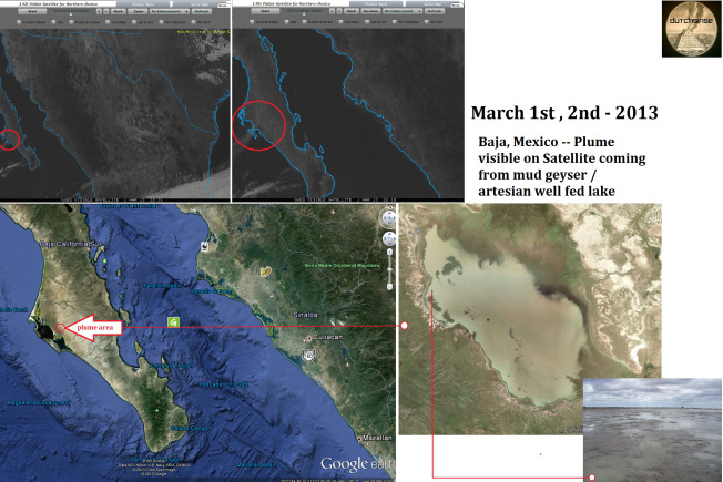
and what about the LAKE in mexico? that can't be burning either.. frack wells.. those can't be control burns.. and neither can the lake

I haven't seen his latest claims on that topic. Last time he was making plume claims in Mexico he was looking at diurnal convective t-storms associated with the North American monsoon. It isn't monsoon season. I'll bet there is something being burned near the lake.

Edit: Found his Mexico post.

http://sincedutch.wordpress.com/201...rge-plume-erupts-from-aquifer-lake-mud-pots/#

He says the plume is coming from a "mud pot" and puts up a picture that he yanked from google earth. He ignored all the other photos of the area that have been uploaded to google earth that show vegetated desert surrounding the "mud pot".

http://www.panoramio.com/photo/63632468?source=wapi&referrer=kh.google.com
 
He seems to be actively hiding all evidence that the plumes he is viewing here are smoke from fires. Immediately west of the "mud pot" in Mexico is a well vegetated area that likely burns often. Here in the southeast it is burn season with hundreds of prescribed fires being conducted when the weather is favorable. That is in addition to some unplanned wildfires that are blowing up. The foresters that oversee the burns publish their plans. The US Forest Service provides a maps of active fires, fires within 24hrs, and fires since January 1. He was provided this information and ignored it. More importantly he has hidden this information from his subscribers.

http://activefiremaps.fs.fed.us/

http://activefiremaps.fs.fed.us/activefiremaps.php

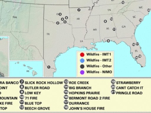
A relative witnessed the SMOKE from the "Slick Rock Fire" #7 in Northern Arkansas within the Ozark National Forest, Sylamore area yesterday afternoon, I could smell the smoke last night, 20 miles north of the fire .


slickrock.jpg
 
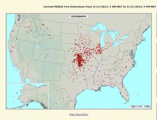
According to the FIRMS Web Fire Mapper there were fires in that exact location between March 1st and 5th.


FIRMS map showing fires where dutch claims there are "plumes"


Dutch's images from his blog post sowing his "plumes" where fires are indicated.


Last edited by a moderator:
Edit: On further investigation the plumes he highlighted are not smoke but are decaying t-showers verified over the Serranias Del Burra Range by the Austin NWS office. The smoke that his facebook fans confirm is likely drifting from numerous fires that are burning along the Sierra Madre Occidental. See subsequent posts below for details.


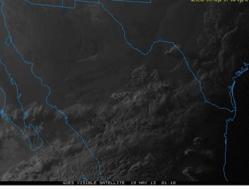
Yet another case in which Dutch claims that smoke from a fire showing up on visible satellite is a volcanic plume.

http://sincedutch.wordpress.com/201...r-dormant-volcano-very-close-to-texas-border/

Dutch says on Facebook:

NOT a wildfire.. or a storm...this is directly next to a dormant volcano in the desert..

movement in the area CEASES after sunset.. check the texas charts to see what im talking about

Now fires, controlled and prescribed tend to lay down at night when the atmosphere stabilizes, relative humidity increases, and winds relax. But Dutch thinks that such behavior would be more typical of seismic activity. Okie doakie dutch.

What is really interesting is comments to his facebook by his fans:

Janice Sharp The air here in Cental TX has been very 'hazy' for the last couple of days, and it's very, very windy...thought it was about the "Mexican" smoke that happens in the spring..BUT a plume from a dormant volcano! wow.
Like · Reply · 2 · Yesterday at 8:22am


[Broken External Image]:[URL]https://fbcdn-profile-a.akamaihd.net/hprofile-ak-prn2/s32x32/260914_100002225465636_1002645052_q.jpg[/URL]

Cheryl F. Wright That is incredible. KVUE. Issued a statement tonight that they would be burning in Mexico this coming week. That is a huge plume! Wonder if earthquake is next.

Their posts effectively confirm that it is fires but then they accept Dutch's volcano "theory"? I'm not sure how that works in their heads.

And directly next to a dormant volcano? In the desert?

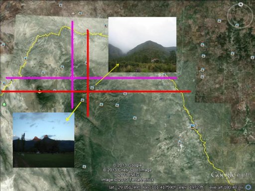
Well it is actually about 30km away from the volcano you point out and it is in an area that has a lot of vegetation. I used the border between TX and MEX to find the approximate location of the "plume" origin and the volcano that dutch thinks is erupting. I found that he did not accurately overly the smoke image on the map. He also failed to look at any of the photos in the area. I pasted copies of the two photos taken nearest where the smoke is visible on to the image I got from google earth. I see a lot of vegetation that is probably apt to be burning this time of year given the ecology of that region. Is he hiding something by these mistakes? Or is he suffering confirmation bias to the extent that he cannot help but ignore all evidence that is contrary to his theory?

plumes-volcano-may-19-2013_vis_sat.jpgdutchssupposedvolcano.jpg
 
Last edited by a moderator:
Sorry, forgot to add a legend. Magenta lines cross at the volcano. Red lines cross at the origin of the smoke plume.
 
This could probably go into the psychology of believers thread. He seems to really believe that he is seeing something that every professional meteorologist and geologist alike either cannot see or is deliberately trying to hide.
 
Dutch says:
If you look at the area on Google earth, you will quickly come to see
1) It is a desert

I see a lot of vegetation in that desert when I look at the photos that users have uploaded to google earth.
 
Also, that probably wasn't a fire. I got Dutched and jumped the gun without taking a good look at his image.

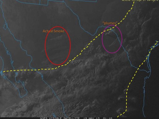
He did not provide a loop of the satellite images so I cannot be sure. But that looks like a likely a decaying t-shower with an anvil top blowing to the east. Looks more like towering cumulus than smoke. The shadow that the "plume" casts indicates that it was very tall. There was cold air aloft in the area and storms/weather to the southeast of the "plume" so it is plausible that it was a pop-up t-shower over the mountains.

I clipped out a broader capture that he posted. You can see the weather in the area. Stands to reason that you might get a pop-up shower over the mountains during the afternoon in weather like that. Certainly looks like the plumes were associated with the weather demarcated between the dotted lines. I circled actual smoke plumes (verified by the firmis fire mapping website) for contrast. I'm going to go find the forecast discussions from that evening from the Austin NWS office.


plumage.jpg
 

Attachments

  • plumes-volcano-may-19-2013dutch.jpg
    plumes-volcano-may-19-2013dutch.jpg
    143.7 KB · Views: 657
Austin National Weather Service discussions from Saturday afternoon (keep in mind that Dutch's screen capture of the plume was at 8pm CDT).

AREA FORECAST DISCUSSION
NATIONAL WEATHER SERVICE AUSTIN/SAN ANTONIO TX
845 PM CDT SAT MAY 18 2013

.UPDATE...
THE EARLIER EXTENSIVE CLOUD COVER INHIBITED CONVECTIVE DEVELOPMENT
OVER THE SERRANIAS DEL BURRO RANGE FOR THE MOST PART. RECENTLY TWO
SHOWERS DEVELOPED..
.BUT THEY HAVE ALL BUT DISSIPATED. WILL REMOVE
ISOLATED POP MENTION OUT WEST.


Previous:

AREA FORECAST DISCUSSION
NATIONAL WEATHER SERVICE AUSTIN/SAN ANTONIO TX
327 PM CDT SAT MAY 18 2013

.SHORT TERM (TONIGHT THROUGH SUNDAY NIGHT)...
WEAK ELEVATED CONVECTION MOVING NEWD ACROSS S CENTRAL TX THIS
AFTERNOON...WITH THE HIGH CLOUDINESS FROM THE PACIFIC KEEPING
TEMPERATURES DOWN 5-10 DEGREES OVER THIS TIME FRIDAY. BROAD UPPER
TROUGH OVER THE WESTERN CONUS FOR THE NEXT SEVERAL DAYS WILL KEEP
A SWLY FLOW ALOFT ACROSS S TX. SERIES OF DISTURBANCES IN THE SWLY
FLOW WILL TRACK ACROSS W/SW TX ACROSS CENTRAL/NORTH TEXAS...SOUTH
TEXAS WILL REMAIN ON THE SRN EDGE OF MORE ORGANIZED CONVECTION.
THEREFORE ONLY EXPECT ISOLATED STORMS EACH LATE AFTERNOON AND
EVENING WITH HEATING OVER THE HIGHER TERRAIN OF THE HILL COUNTRY
AND ALONG THE DRY LINE OVER THE EDWARDS PLATEAU.
OTHERWISE CONTINUED
UNSEASONABLY WARM SUNDAY...ALTHOUGH THE PACIFIC MOISTURE/CLOUDS
SHOULD HELP KEEP TEMPERATURES SHY OF RECORD HIGHS.
 
Last edited by a moderator:
Austin National Weather Service discussions from Saturday afternoon (keep in mind that Dutch's screen capture of the plume was at 8pm CDT)...


We've still got about 6 weeks or so before the monsoon season starts and we see the "plumes of doom" around Mono Lake, Pisgah Crater, etc., again. The Georgia and Arkansas fires ended and he needs to keep people interested. He also posted this recently,
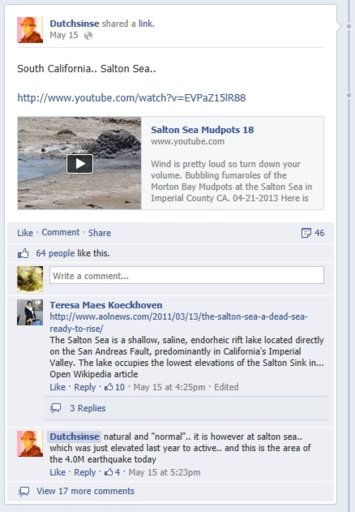
Salton.jpg , (I kind of feel bad for the guy that produces these videos, Dutch sends his followers over to him, and he has to keep explaining that there is nothing unusual in what he is filming, only that he just finds it interesting) Dutch doesn't have the honesty to explain to his viewers that the upgrade in status has nothing to with the probability of a possible imminent eruption, only that it means it last erupted more recently than previously thought. I think it would be interesting to look at the radar loops of volcanoes that are actually actively producing plumes and compare it to Dutch's loops. I just don't have the patience to stare at loops all night in the hopes of finding something that his followers don't understand. I actually have a life.

One thing that i find entertaining, fracking has been going on in my part of California (San Joaquin Valley) for over 50 years, so far Dutch hasn't attributed any of our temblors to fracking. I wonder how long it will be before he realizes this?
 
Most of the anti fracking folks don't know that and if they do, they don't let it bother their rants against it.

Fracking does have some problems, but no where near the number of issues that it is blamed for.
 
Most of the anti fracking folks don't know that and if they do, they don't let it bother their rants against it.

Fracking does have some problems, but no where near the number of issues that it is blamed for.

Indeed there are a few problems, and the oil companies should be heavily watched and regulated, if it leads to a profit, they will take any short cut they can. We've had a few minor problems in the valley, http://www.bakersfieldcalifornian.c...er-gets-another-bumper-crop-of-disappointment, and I hope one day Mr. Starrh and others will one day get their just due. It's just that not every single earthquake in the midwest in the past 2 years has been caused by fracking, as Dutch implies, just as every major storm has not been man made and directed, and for almost certain, fracking will not be the cause of the next New Madrid earthquake as seen in the 1860's as dutch's followers are lead to believe.


Until we find a clean energy source that meets our demand, I see little choice but to allow fracking to continue (closely monitored of course). These same people that complain about the fracking would be the first to be screaming and yelling if fracking, nuclear, coal... were to be banned and we only were allowed to turn on lights for a few minutes per evening or only alowed to drive our cars to get to work, if we had that luxury.
 
It is burn season again in the south. Lots of wildfires and prescribed fires under the dry high pressure yesterday. He is pushing his plume bunk again.

From his facebook page:


He is mystified by the timing. Control burns and wildfires alike peak in intensity during the relative humidity minimum and diurnal mixing peak in the early to mid afternoon so that is when they are visible on satellite imagery.

He also noticed the seasonal pattern. What he is ignoring is that daily fire activity is summarized at:
http://gacc.nifc.gov/sacc/predictive/intelligence/SACCMorningReport.pdf

There are also burn plans available from the national forests and state agencies that are doing burns.

He was supplied all the nessecary to locate the fires last year so he should know that these are fires. Fire behavior was explained to him as well.

What he observed yesterday was exactly the same as when it was sunny and dry last March.

Scombrid or Timsolrey, did either of you get screen shots or permalinks. I went back through his timeline and can't find the posts, the 2 videos he made in March are no longer available on you tube. Check out what Dutch posted, yesterday. I'm glad that you got the quotes documented.

plume1.jpg
https://www.facebook.com/DutchsinseOfficial/posts/624479144271180
 
Unfortunately I do not have screen shots or permalinks.

I did find some sites from which he has not deleted the record of his having made plume vids in March 2013. He may have poofed the evidence from his facebook timeline and from youtube but there is a record apart from this thread that he made a plume vid in 2013 in spite of his claim in that facebook post you capped. The post are essentially mirrors of what he had posted on sincedutch blog.

http://wingsoflyra.blogspot.com/2013/03/dutchsinse-382013-large-plume-event.html

http://ascendingstarseed.wordpress....tate-of-georgia-into-ms-al-sc-nc-watch-in-hd/

http://alt-market.com/forum/economi...ewcratons-plumes-earthquakes-volcanoes-a-safe

So he claims that 2011 and 2012 were the only years that he observed such an event. Meanwhile there is a record of his having made a video on the topic in March 2013. Now what should we think of his having deleted his plume videos from March 2013 as well has purging his facebook of plume mention in March 2013 and then claiming that he has not again seen a plume event like those in March 2011 and 2012?

Well, we now have a record of his claim here. We can revisit the topic in March 2014. It won't take any special effort on our part. He claims to check for the plumes every day. Since we know that the plumes in question are pre-season prescribed burns. We'll know by the weather and published burn plans when to look.
 
Last edited:
Unfortunately I do not have screen shots or permalinks.

I did find some sites from which he has not deleted the record of his having made plume vids in March 2013. He may have poofed the evidence from his facebook timeline and from youtube but there is a record apart from this thread that he made a plume vid in 2013 in spite of his claim in that facebook post you capped. The post are essentially mirrors of what he had posted on sincedutch blog.

http://wingsoflyra.blogspot.com/2013/03/dutchsinse-382013-large-plume-event.html

http://ascendingstarseed.wordpress....tate-of-georgia-into-ms-al-sc-nc-watch-in-hd/

http://alt-market.com/forum/economi...ewcratons-plumes-earthquakes-volcanoes-a-safe

So he claims that 2011 and 2012 were the only years that he observed such an event. Meanwhile there is a record of his having made a video on the topic in March 2013. Now what should we think of his having deleted his plume videos from March 2013 as well has purging his facebook of plume mention in March 2013 and then claiming that he has not again seen a plume event like those in March 2011 and 2012?

Well, we now have a record of his claim here. We can revisit the topic in March 2014. It won't take any special effort on our part. He claims to check for the plumes every day. Since we know that the plumes in question are pre-season prescribed burns. We'll know by the weather and published burn plans when to look.

I've told Dutch repeatedly that the internet has a long memory. I guess he will never learn. Thanks for the links. I've got screen shots of them, in case dutch tries to scrub those records too.
 
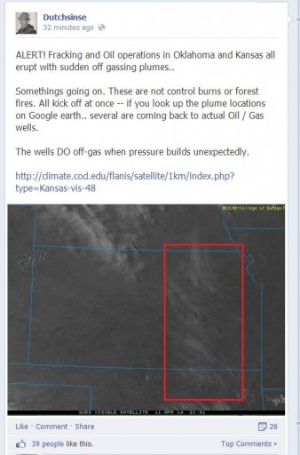
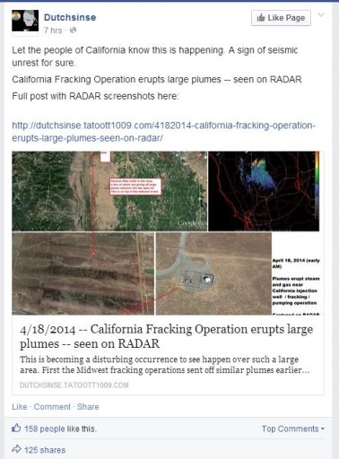
Today, it's a volcanic plume in the eastern Sierra's in Tulare county, CA.

plumes.jpg
http://dutchsinse.tatoott1009.com/4...just-southeast-of-golden-trout-creek-volcano/

Sorry Dutch,
That followed a record high minimum of 63° Friday morning which was a springboard to warmer temperatures than initially expected for the afternoon. Cooling from the low pressure system arrives overnight with a brisk westerly flow in Kern County. That low has also brought instability in which thunderstorms broke out northwest of Ridgecrest in Tulare County Friday afternoon.
Content from External Source
http://www.bakersfieldnow.com/weather
 
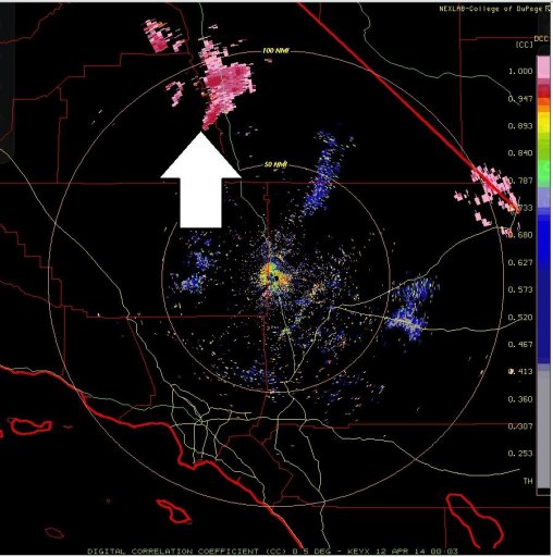
Now I am no expert in seismology or vulcanology like Dutch is, but wouldn't it be safe to say an ash cloud, his "volcanic plume", would have characteristics similar to plain old smoke? If that is the case, and again I am no expert on "plumes", the radar imagery he is showing would look a lot different. I say that because I am quite thoroughly familiar with radar imagery and how to properly interpret it.

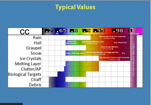
Assuming a "volcanic plume" would contain particulates similar to plain old smoke, the correllation coefficient for his "plumes" should be much lower than they are in his screen capture from the KEYX radar. His plume shows as mostly pink - a high degree of correlation - meaning whatever the radar energy was hitting was very similar in composition. Would a "volcanic plume" have such uniformity?

Thanks for the screencap Dutch:

cc edwards 11 april.JPG CC Values.JPG


In addition he shows the Differential Reflectivity product from KEYX.

Differential Reflectivity (AKA ZDR) measures the absolute difference between the horizontal and vertical reflectivity pulse. In general, if ZDR is near zero, it means the difference is small, so the return is more spherical in shape.


Smoke, or volcanic plumes, as seen on weather radar, would most likely have a very high / erratic ZDR. As we can see on his animated gif (again, thanks Dutch for the assist in debunking your nonsense), we see a ZDR that is very low, light to dark blue - at or near zero 0 the scale seen to the far right, indicating whatever the radar energy was hitting, it is very close to spherical in shape and most likely some type of precipitation.

http://i1.wp.com/dutchsinse.tatoott...exlab.NEXRAD.EYX_.N0X.20140412.815.200ani.gif

A word of advice Dutch - I know the radar products you use look pretty sweet on College of Dupage, almost "Star Warsy" in some ways, and that such imagery is enough to convince your viewers - but LEARN how to interpret weather radar and what it all means BEFORE using the dual polarization products to debunk yourself.
 
When he says 'plumes' is he referring to methane?

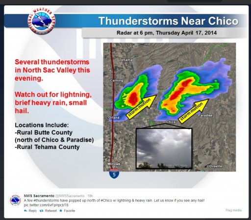
Pete, Dutchsinse has no explanation other than it is a plume that he doesn't understand, if he can find an oil rig, it's a hit, so he can spread his fear porn. This was the outlook for today from the NWS, notice the areas of convection that were predicted, Untitled1.jpg
http://www.spc.noaa.gov/products/outlook/day1otlk_2000.gif ,

and our real time
Untitled.jpg

http://www.weather.com/weather/map/...&cm_cat=GW&cm_pla=DopplerRadar&cm_ite=Adcopy1

With the earthquake today in Mexico, I expect Dutch will find a hit somewhere along that line of thunderstorms along the Sierra ridge.
 
Back
Top