Debunked: Photo of "Nessie" in Apple Maps Satellite image of Loch Ness [Boat]

CapnPegleg

Member
[Update by @Mick West: OP Modified to include debunking info from the thread]

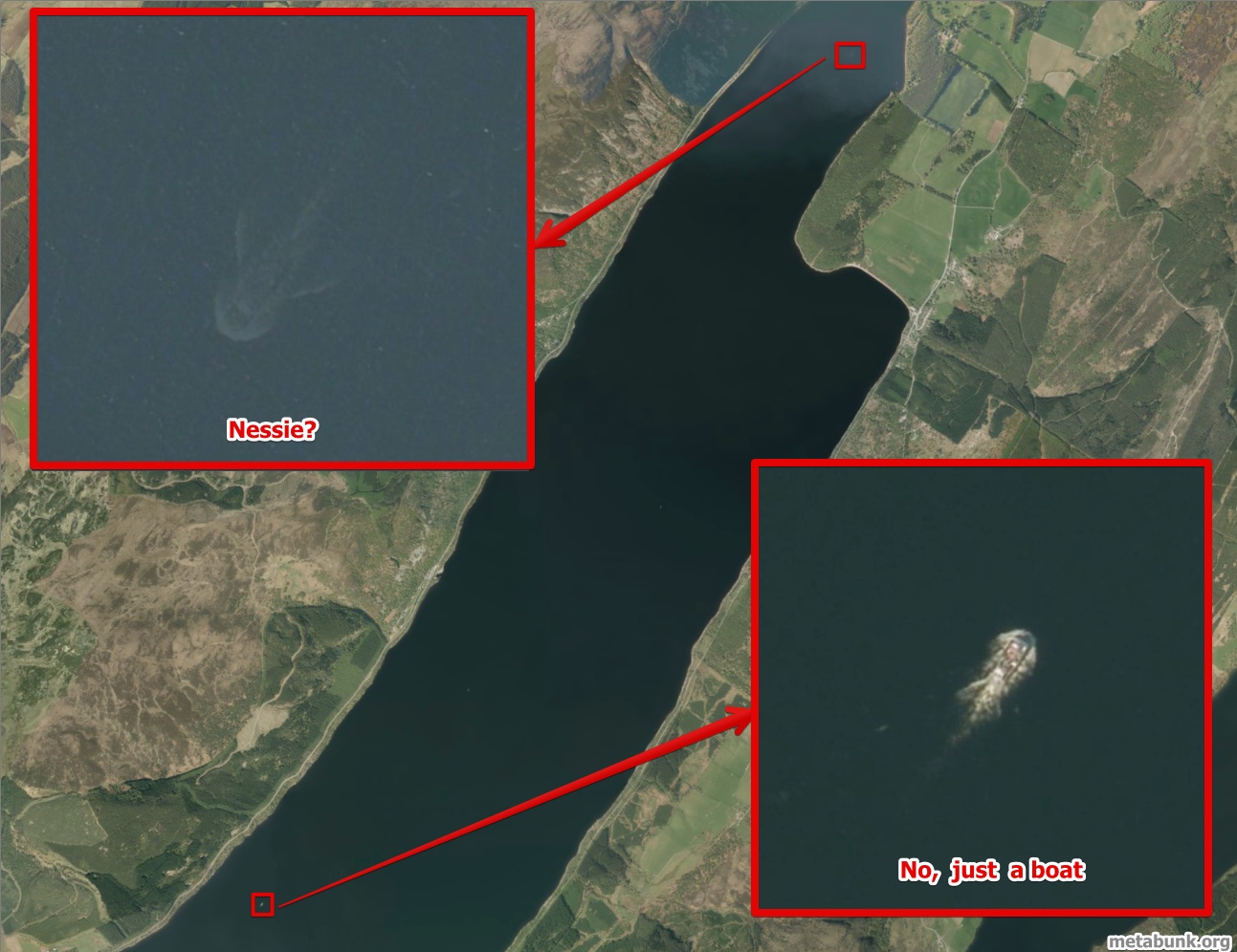
Various "news" outlets picked up the story that an image in Apple Maps appears to show some kind of giant fish underwater:

http://www.dailymail.co.uk/news/art...nster-Apples-Maps-satellite-image-Nessie.html


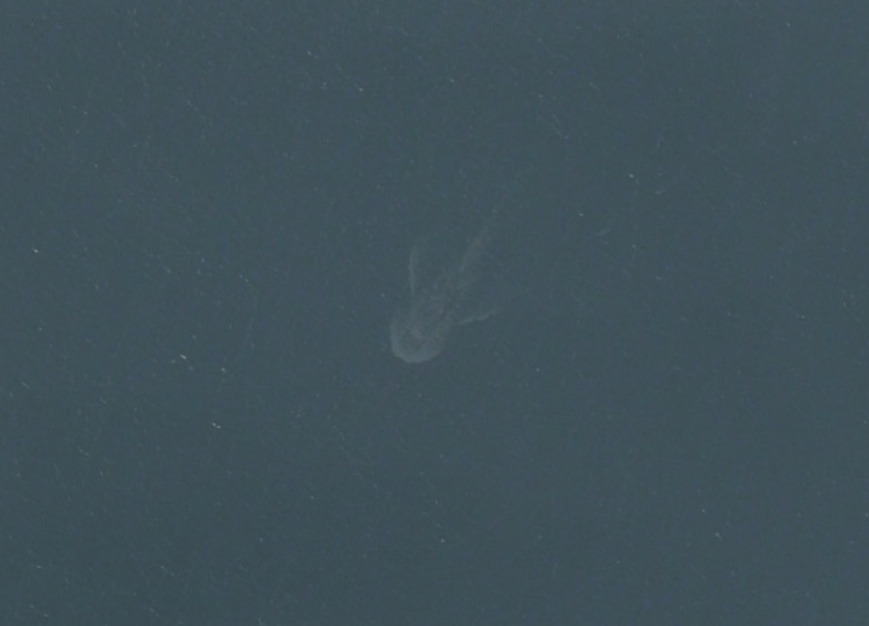
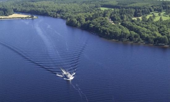
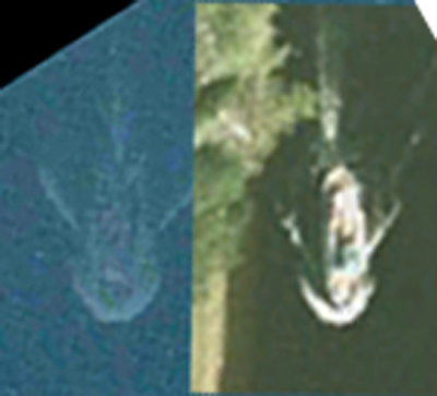
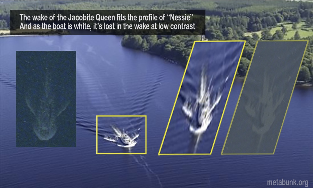
However it looks exactly like the wake of other boats on the loch, just dimmer


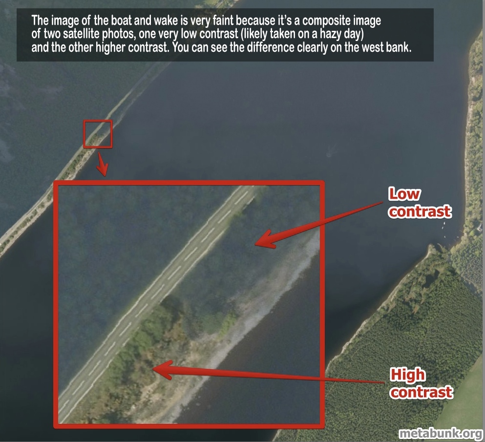
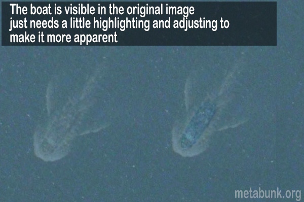
It's dimmer because of the way different images are stitched together to create a seamless image. The area with Nessie is not simply the low contrast image, but it's also blended with a higher contrast image without the boat, which is why you can see some texture in the surface of the water through the boat wake, making it look like it's underwater.


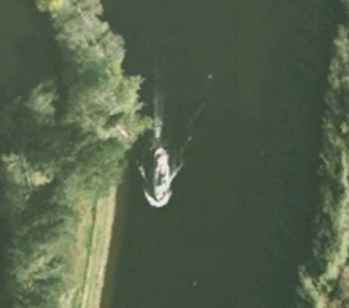
And we can even see what boat it is: (thanks @jonnyH )


Last edited by a moderator:
Looks like a cargo ship to me... If you look inside the things that look like fins, the lines are far too straight to be natural.. and if you look more towards the front you can make out what LOOKS like the curved bow of a boat, and maybe some cargo containers near the mid section... Im at work so I dont have much to work with, but at first glance it looks like the ghosted image of a boat.
 
looks like a boat and the wakes around it.

ness.JPG
which is good because Nessie is much prettier than that!!
 
Looks like a cargo ship to me...

I dont think you get cargo ships navigating around Loch Ness. There are no significant ports, adequate roads for haulage and simply not enough of a population to make it worthwhile.

On the other pictures there are some boats moored up to the south east of "nessie" which according to the scale (google maps) are about 5m long at most. You can even see the buoys they are moored to. wouldn't a cargo ship with containers show up as plain as day?

That said, it does look a lot like this:

https://maps.google.co.uk/maps?q=loch ness&ll=57.411515,-4.326237&spn=0.001887,0.004823&client=safari&oe=UTF-8&hnear=Loch Ness&t=h&z=18


probably a pleasure boat or a ferry.
 
this is what first came to my mind. they can get pretty big, but I imagine one the size in that Nessie photo would mess up the ecosystem pretty bad.

8038646_f260.jpg
 
It doesn't fit the profile of a long-necked sea creature anyway, more like a whale-shark.
Whale sharks tend to come to the surface a great deal and ate lumbering. The loch would never hold enough food for one.

This is a guilty secret but I dived there in my late teens a few times (84 and up). It was part of a cycle we did including Scapa Flow and out in the Clyde. Got see some otters, loads of char but unfortunately no Nessie. I was up there a few years back for a music festival (Belladrum) and as the coach drove along the Loch you could not help but look out and maybe dream.

Beautiful part of the World btw. Go visit.
 
Here's a pic I created for a discussion on another forum about this topic. Someone found a boat on a Google Maps image that while being clearer and brighter, looks pretty much the same as the "monster" appears on the Apple Maps image, and appears not much further north on a canal or river leading north from Loch Ness.

I decided to do an experiment with the image and I took wide images of the area from both Google Earth and Apple Maps (which use different satellite imagery of the area) and overlaid them and resized them until they neatly overlapped so that I knew they were at the same scale. I then cut out the following image of a Loch Ness / Caledonian Canal boat from Google Maps and put it alongside the image of the "Loch Ness monster" image from Apple Maps. The result is that the size and pattern of the both and the monster neatly match up. The monster is faded and obscured looking, but I think that's because of the algorithms that mapping apps use to blend together overlapping tiles from satellite imagery in order to blend out and blur out harsh boundaries between images. There are websites with all sorts of picture of hilarious Google Earth oddities caused by overlapping satellite imagery tiles.

 
Yeah, I think a lot of people very quickly figured it out. It's sad that this is what passes for "news" nowadays.
 
What's also sad is that the news article in the opening said the Loch Ness monster fan club spent SIX MONTHS examining the pic by 'experts' and concluded it was 'likely' the monster. I don't see how that's possible when others can spend five minutes on Google Earth and realise it's just a boat. I suspect they're playing fast and loose with the word 'expert'. What exactly can anyone do with a picture like that for six months without realising the obvious especially if you're some sort of expert?
 
What's also sad is that the news article in the opening said the Loch Ness monster fan club spent SIX MONTHS examining the pic by 'experts' and concluded it was 'likely' the monster. I don't see how that's possible when others can spend five minutes on Google Earth and realise it's just a boat. I suspect they're playing fast and loose with the word 'expert'. What exactly can anyone do with a picture like that for six months without realising the obvious especially if you're some sort of expert?
I think they use expert they same way bigfoot hunters use expert. Example: It could be a stump, it could be a Dodge Charger - the expert says it's Bigfoot.
 
Back
Top