Debunked: Only Four Airliner Flights/Day over Mt. Shasta, CA

Jay Reynolds

Senior Member.
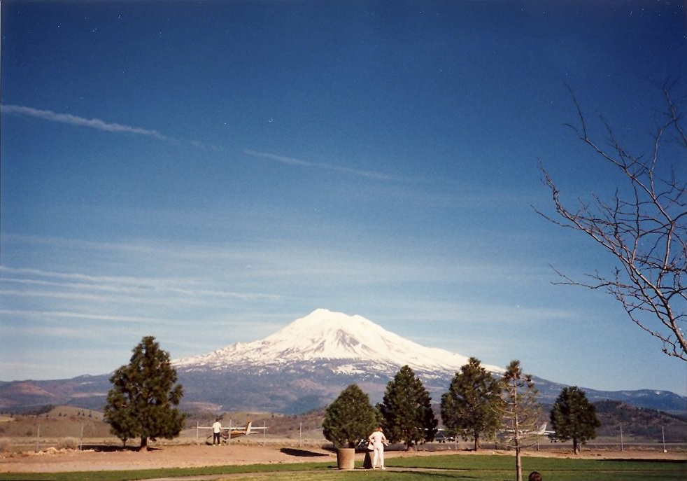
This thread examines false claims by Michael J. Murphy, Dane Wigington, and Francis Mangels that Northern California, and specfically the Mt. Shasta/Redding areas are not under any major flight paths, and that, according to the FAA, less than five flighs per day pass over that area.

I am maing this examination to explain the documentable and confirmable facts about this issue because these false claims have been used to persuade people that:
A- There should be few observable contrails over the area.
B.-The observations indicate indicates the contrails are evidence of "spraying".

When I first learned of these claims, I contacted the above mentioned people and notified them that their claims were false, and explained how they could confirm that what I told them was true. To date they have not modified their false claims and continue to reiterate them.

Here are the relevant quotes:

1. By Francis Mangels of Mt. Shasta, CA:
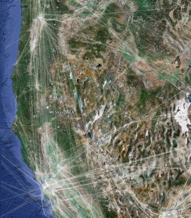
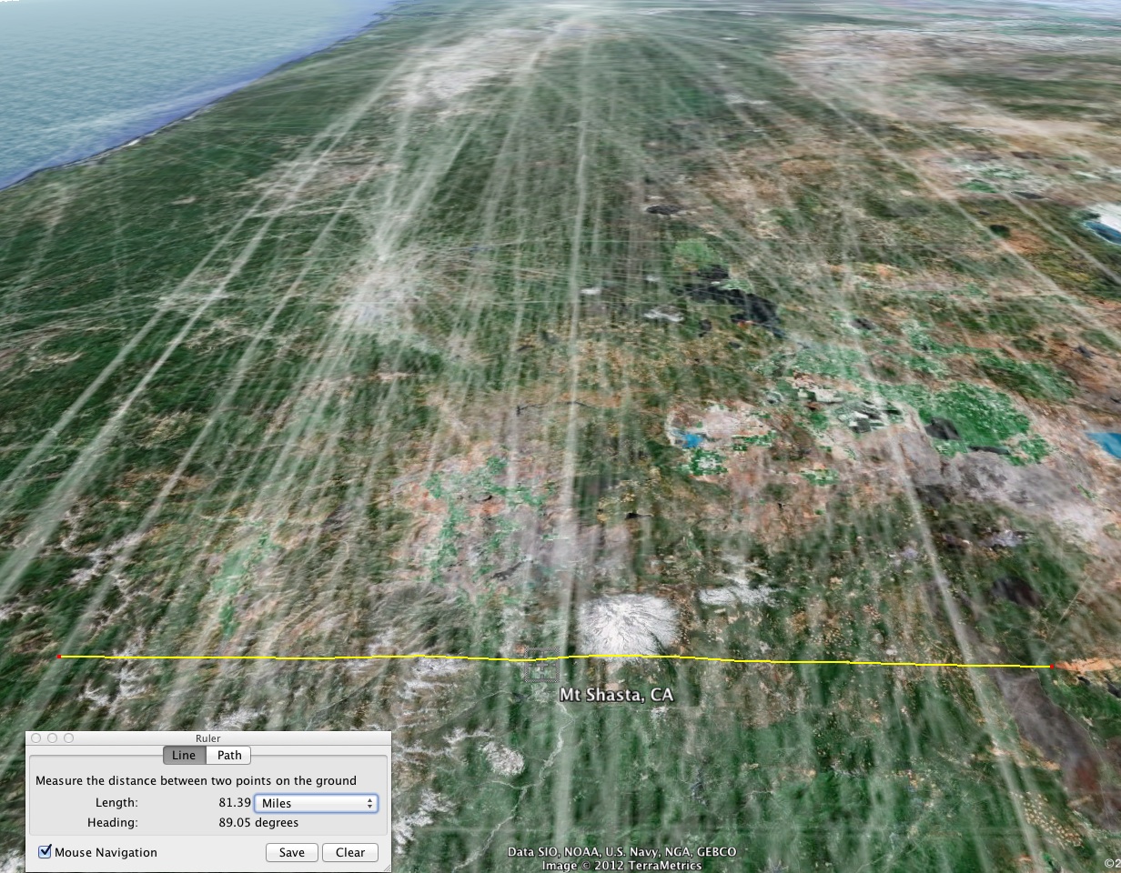
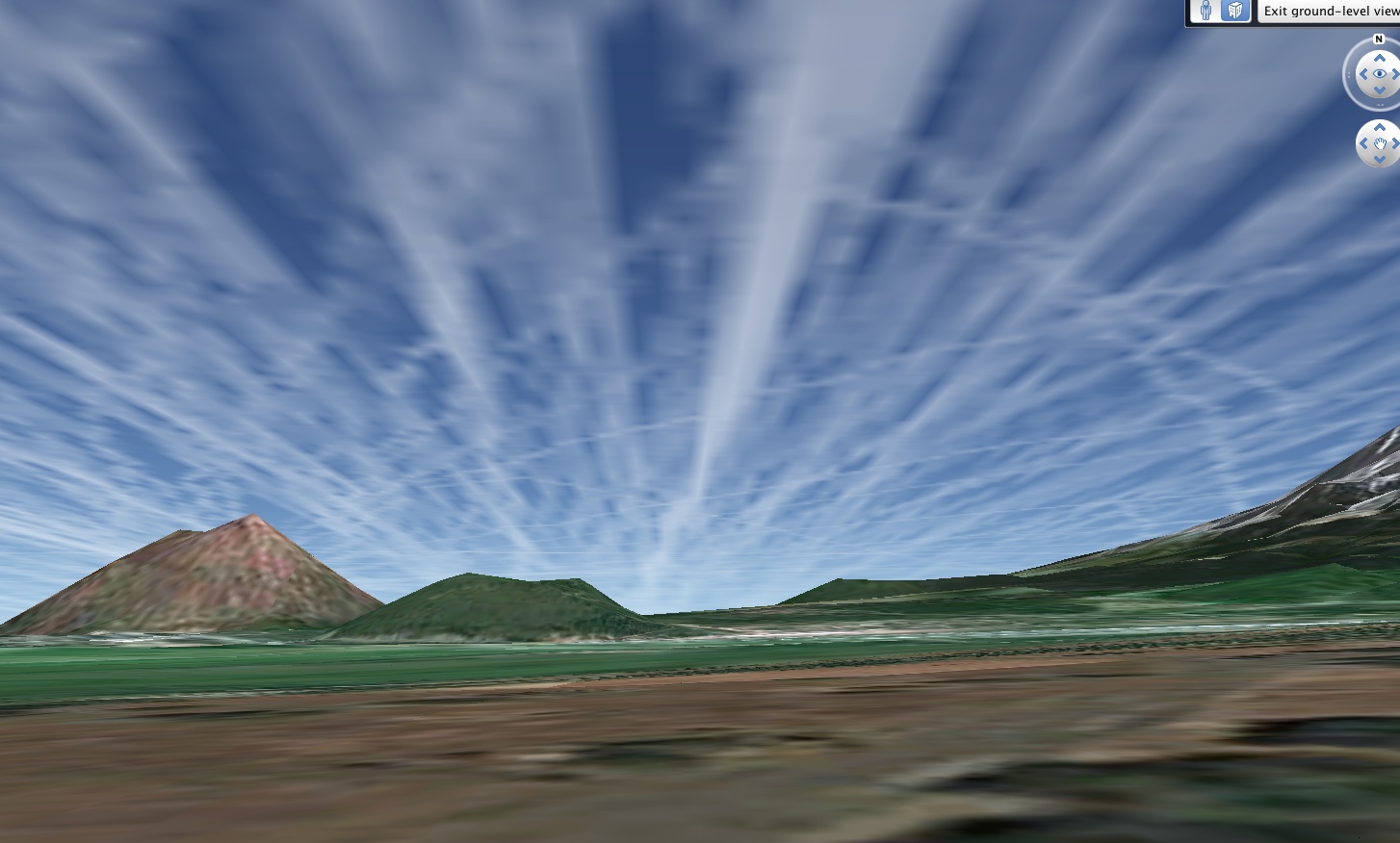
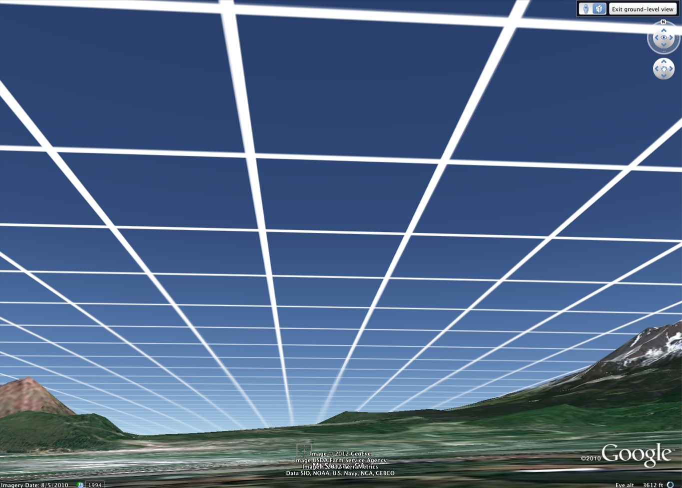
Francis Mangels said:
Many photographs show jet trails crossing at right angles, curves, grids or circles. I have seen tic-tac-toe inside circles. Commercial jets fly straight.

Since there are no east/west commercial flights over N. California according to FAA, it’s military.

Counting all trails in every direction over Mt. Shasta, the FAA indicates 3 flights per day. We count over thirty contrails at once, over 100 just before weather fronts.

Commercial jets do not suddenly increase their flight schedules just before a weather front. Heavy spraying days are just before weather fronts, it is therefore military.

Some contrails converge to a point, often over Mt. Shasta, then re-align, cross, curve, or radiate (asterisk-like) out from the mountain. This is no commercial flight pattern.
http://www.geoengineeringwatch.org/documents/GeoEngineeringWhatWeKnow.doc

2.By Michael J. Murphy in an interview with "Food Integrity Now" @ 17:00:

Michael J. Murphy@ 17:00 said:
The story I wanted to share with you is about Dane Wigington, who is a solar power expert and he’s also worked in lightning suppression, so he’s studied weather and he has 2000 acres overlooking Lake Shasta and we interviewed him and it’s very sad because much of the plant life there is dying off, but we spent a couple of days there in the late fall and on his property there was a big winter storm that was coming in and I think it was projected to drop 3” of rain. And when we woke up in the morning he said, “Michael, what do you hear?, and I said “I hear jets”, and he said “we are not at all in a flight path, but you will hear these jets flying by all day, its very common,” and what he said was, “What I think they are doing is seeding the clouds, sequestering the moisture, you see, barium is a desiccant, and it will change the molecular structure of the clouds so it will not rain.”http://www.blogtalkradio.com/finteg...rphy-and-g-edward-griffin-chemtrails-revealed
 
The first way that Mangels and Wigington could have started gathering information about local air traffic would have been to obtain an aeronautical chart of their area and ascertain whether or not there are established airways passing nearby.

I have surveyed ordinary flight paths over this area and find that if you go to this website:
http://skyvector.com/
Then hover over "charts", then click on "Enroute High" you can access H-3 chart for Northern California.

This chart shows airways used by high altitude traffic passing through Northern Caifornia and clearly shows many airways nearby to the Mangels and Wigington locations:

skyvector.JPG

As you can see from the above image, the claim by Wigington that "we are not at all in a flight path" is ridiculous, and one can only conclude that Wigington:
Never bothered to confirm flight paths over his area before making the statement to Murphy.
or
He was misled by others into a false belief and never checked.
or
He was deliberately making a false claim.

Since that time I have informed him, but he has not retracted his claim.
 
Over one year ago, after emailing Mangels informing him of his errors, I spoke to him by telephone and he reiterated his claim that only 3 flights/day passed his area, so I suggested to him that he should undertake a survey of ordinary traffic using a flight tracking website called
Flightaware which allows viewers to track flights in real time and to view archived flight records.

Here are several examples of what can be learned using this tool:

Southwest Airlines flight 2116 from San Jose, CA to Seattle flew over the Mt. Shasta area on 1/22/2012.
Select full screen and Earth View to see Mt. Shasta in perspective:

http://flightaware.com/live/flight/SWA2116/history/20120123/0430Z/KSJC/KSEA

You an view a minute-by-minute log of the flight showing course, position, speed, altitude, etc.:
http://flightaware.com/live/flight/SWA2116/history/20120123/0430Z/KSJC/KSEA/tracklog

Here are other typical flights:
Oakland, CA to Seattle
http://flightaware.com/live/flight/ASA357/history/20120122/1700Z/KOAK/KSEA

San Francisco to Seattle:
http://flightaware.com/live/flight/UAL733/history/20120123/0344Z/KSFO/KSEA

Vancouver, Canada to San Francisco:
http://flightaware.com/live/flight/UAL378/history/20120123/0039Z/CYVR/KSFO

In fact, practically all north/south jet traffic between any California airport and more northerly airports such as
Portland, Oregon (KPDX)
Seattle, Washington (KSEA)
Vancouver, Canada (CYVR)
fly over the Mt. Shasta area.

Here are the possible California departures and destination cities, and their airport abbreviations:
San Francisco(KSFO)
San Jose (KSJC)
Oakland (KOAK)
Sacramento (KSMF)
Los Angeles (KLAX)

Remember, these flights run both ways several times/day, beginning before dawn and ending into the night. There are a lot of airlines serving these routes, with many flights/day.
 
In general, the majority of flights over the Mt. Shasta follow the airways running just west of the mountain, however some flihts are directed along the easterly routes. This can be seen in the following videos by ordinary tourists:
Northbound, Mt. Shasta on the right:


Southbound, Mt. Shasta on the left:


Even a cursory youtube search should have let Murphy, Mangels and Wigington know that ordinary air traffic along the west coast almost certainly had to pass over the area.
 
I haven't had much luck finding data for flights from European airports to KSFO. Usually, I think they fly farther south, but I was on a flight from Frankfort to San Francisco once that passed just south of Mt. Shasta in a southwest direction, then veered south.
 
In fact, practically all north/south jet traffic between any California airport and more northerly airports such as
Portland, Oregon (KPDX)
Seattle, Washington (KSEA)
Vancouver, Canada (CYVR)
fly over the Mt. Shasta area.

Here are the possible California departures and destination cities, and their airport abbreviations:
San Francisco(KSFO)
San Jose (KSJC)
Oakland (KOAK)
Sacramento (KSMF)
Los Angeles (KLAX)

Remember, these flights run both ways several times/day, beginning before dawn and ending into the night. There are a lot of airlines serving these routes, with many flights/day.

I'm about 80 or 90 miles south of Portlandia, er Portland, OR and most if not all of those flights come within sight of my location on the western edge of the central Willamette Valley. I haven't done a purposeful count, but I'd guesstimate at least 40 or 50 airliners a day fly within view. We have plenty of days with a mix of natural cirrus and persistent contrails too. I noticed another forum member, ThorGoLucky, mentioned the neighboring town of Philomath in another thread and I'm like 5 miles east of there so perhaps they could verify that count...maybe even knock back a local microbrew or two sometime?

cheers
 
On 2/13/2012, I tracked the following flights over the Mt. Shasta area between 6am and 6pm, and downloaded the .kml flight tracks for each one which can be displayed on Google Earth:

Oakland(KOAK) to Seattle (KSEA)

Airline Flight# Departure Time
ASA 347 0630
SWA 664 0645
ASA 357 0900
SWA 1060 0905
SWA 3131 1135
SWA 907 1545
ASA 345 1745
SWA 425 1800

Seattle(KSEA) to Oakland(KOAK)
ASA 342 0610
SWA 2077 0750
QXE 637 1000
SWA 1874 1120
SWA 3284 1515
ASA 36 1725

Seattle(KSEA) to San Jose(KSJC)
ASA 320 0652
ASA 324 0930
SWA 3101 1015
ASA 328 1559

San Jose(KSJC) to Seattle(KSEA)
ASA 323 0630
ASA 227 0920
SWA 169 1010
ASA 325 1222

San Francisco(KSFO) to Seattle(KSEA)
ASA 315 0700
UAL 276 0700
VRD 740 0835
ASA 307 0920
ASA 303 1010
UAL 426 1029
SKW 5304 1326
VRD 744 1445
VRD 746 1645
ASA 313 1650
UAL 573 1711

Seattle(KSEA) to San Francisco(KSFO)
UAL 468 0550
VRD 751 0615
ASA 304 0625
UAL 294 0704
ASA 220 0725
UAL 698 0945
ASA 318 0955
VRD 753 1130
ASA 312 1155
UAL 220 1201
VRD 755 1535
UAL 560 1558
ASA 302 1755

Vancouver(CYVR) to San Francisco(KSFO)
UAL 361 0600
ACA 560 0850

San Francisco(KSFO) to Vancouver(CYVR)
ACA 559 0730
UAL 957 1030
UAL 567 1125
SKW 6276 1302

San Jose(KSJC) to Portland(KPDX)
QXE 546 0615
SWA 3003 0755
ASA 403 0850
QXE 188 1205
SWA 534 1325

Portland(KPDX)to San Jose(KSJC)
ASA 400 0615
SWA 278 0715
QXE 187 0920
SWA 1015 1115
SWA 3404 1440
ASA 404 1559

(continued)
 
Oakland(KOAK) to Portland(KPDX)
SWA 1104 0610
QXE 636 0905
SWA 708 0905
QXE 644 1200
SWA 3635 1240
SWA 2784 1435
QXE 610 1710

Portland(KPDX) to Oakland(KOAK)
QXE 571 0630
SWA 2187 0630
SWA1525 0820
QXE 589 0925
SWA 797 1110
SWA 3938 1535
QXE 536 1720

Sacramento(KSMF) to Seattle(KSEA)
ASA 371 0630
SWA 344 0700
ASA 365 1015
SWA 684 1020
SWA 364 1300
SWA 1164 1730

Seattle(KSEA) to Sacramento(KSMF)
ASA 364 0640
SWA 1070 0700
ASA 368 1050
SWA 208 1140
SWA 1207 1455

Sacramento(KSMF) to Portland(KPDX)
SWA 1436 0645
SWA 309 0800
SWA 521 1110
SWA 813 1520

Portland(KPDX) to Sacramento(KSMF)
SWA 2899 0645
SWA 3181 1005
SWA 524 1150
SWA 3813 1445
SWA 298 1635

San Francisco(KSFO) to Portland(KPDX)
ASA 573 0640
ASA 579 1800

Portland(KPDX) to San Francisco(KSFO)
ASA 576 0640
ASA 578 1253

Los Angeles(KLAX) to Portland(KPDX)
SKW 5269 0709
ASA 563 1035
SKW 6235 1133
DAL 8842 1635

Portland(KPDX) to Los Angeles(KLAX)
ASA 560 0655
ASA 562 0955
SKW 5468 1007
SKW 6235 1435

There were some flights which for some reason I was not able to download the flight data, and certainly many more flights later in the day, which would be visible during daylight hours during spring and fall as day length increases. Perhaps during certain seasons there will be more flights. This list only includes passenger flights, and excludes private jet and cargo traffic.

As you can see, there is an entire fleet of planes crossing over the Mt. Shasta area every day.

Thousands of people look down each day in awe of the beautiful mountain, blissfully unaware that Francis Mangels, Dane Wigington, and many others look up falsely thinking they are being sprayed with poison.

Tomorrow I will reveal what the flight paths actually look like in Google Earth and will provide a downloadable file containing all the flight tracks combined which anyone with Google Earth can open and will be able to view from the exact perspective of Dane Wigington and Francis Mangels, or of anyone else along these flight paths.

I guarantee you will be amazed.
 
[video=youtube_share;6E_Z_Ve-ayA]http://youtu.be/6E_Z_Ve-ayA[/video]

This is even more conclusive proof. The boundaries drawn are not the geographical boundaries of the US... they are the ARTCC (ATC) boundaries. SFO and LAX are easily discernible... as is the amount of traffic heading north out of them.
 
There's many more....


I always enjoy the views of Mt Shasta and Mt Hood, when flying to Seattle from Los Angeles.


and back !!
 
Aaron Koblin's visialization is quite good for this kind of thing. 24 hours of recorded US flight traffic. Not perfect as it also includes low altitude GA flights, but the majority of the long lines will be at contrail altitude.
http://www.wired.com/special_multimedia/2009/ff_airspace_map_1703

Here it is overlaid over the Shasta region. San Francisco is in the south, and Portland and Seattle are to the norht


Here's an 80-mile wide segment centered on Shasta (so no contrail is more than 40 miles away, so easily visible)


It's a bit low resolution, but here's the view from the ground


And here's a 5-mile grid at 35,000 feet. The top horizontal line visible is actually ten miles away.
 
Last edited:
The attached file below combines all 113 flighttrack files in .kml format. Anyone can download this, and opening it in Google Earth will allow you to see exactly what Francis Mangels would see if the day's air traffic all left persistent linear contrails.
View attachment Shasta Tracks Combined Lines nologo view.kml

This is the view from space:

13February2012 flights.jpg

Here is a closer view:

13February2012-100 miles.jpg

Here are the flight tracks as seen from Mt. Shasta, CA, the town where Francis Mangels lives:

shastaview.jpg

Here are the flight tracks as seen from Dane Wigington's rooftop:

trailsviewwigington.jpg
 
Here is the same view with Dane Wigington in the foreground, seen in the propaganda movie "What In The World Are They Spraying"

Note that you can see Mt. Shasta to the right of his chimney, and the direction of the contrails matches the flight tracks of ordinary commercial airliners which I downloaded:

roofwig.jpg

Here is historic travel photo, taken in 1980, 22 years ago, showing the same contrails in the same direction:


PS, I'm happy to see that this thread has attracted over 100 page views in the past 24 hours. This should give Francis Mangels, Dane Wigington, and Michael J. Murphy something to think about. If they think that they can control the flow of information such that their cohorts don't find out that they have been given false information, they need to think again.
 
Last edited by a moderator:
Great Work. I think there are a few smaller airports in Oregon, KEUG, KRMD, KMFR, that would add a few. Medford to Sacramento runs twice a week. On the first figure, you have two KSMF's. I think one is KSFO. What is the east-west flight?
 
What is the east-west flight?

That was a brutal 14+ hour flight from Shanghai to Newark, NJ. United Airlines flight 86:
http://flightaware.com/live/flight/UAL86/history/20120213/0855Z/ZSPD/KEWR

If you look at that particular flight, you will see that it seems to have taken a more southernly route that it might take on other days. Long distance flights, especially, often deviate their tracks from day to day to either avoid storms, strong headwinds, or even to pickup additional speed by traveling along strong tailwinds.
So, on some days there will be more or less flights entering US airspace from offshore at a particular location. It is interesting to note that the return flight from Newark to Shanghai doesn't head west at all, rather it heads east from Newark towards Shanghai along a drastically northern track.
http://flightaware.com/live/flight/UAL86/history/20120626/1455ZZ/KEWR/ZSPD
 
PS, I'm happy to see that this thread has attracted over 100 page views in the past 24 hours. This should give Francis Mangels, Dane Wigington, and Michael J. Murphy something to think about. If they think that they can control the flow of information such that their cohorts don't find out that they have been given false information, they need to think again.

Have they been informed of this evidence ? Have they commented on it ?
Will they ?
 
Have they been informed of this evidence ? Have they commented on it ?
Will they ?

These are very good questions. I will be informing them of my findings, but as I mentioned before, my methods were pointed out to them a year ago, by e-mail, and in the case of Mangels, by telephone.
They have been informed of my methods. They have been challenged. Only one has responded.

G. Edward Griffin attempted over one year ago to have members of the "Coalition Against Geoengineering" of which he is Chairman and Michael J. Murphy is President, to apply themselves to the task of using flight tracking software to establish whether or not what the members were seeing are ordinary commercial airliners making he persistent contrals they see.

G. Edward Griffin said:
This project is a two-edged sword. What if we find that all those trails really are coming from scheduled planes carrying passengers or freight? That would mean we have been on the wrong track, and we would have to re-examine our evidence and re-consider our position. There are some who believe that spraying is done by planes performing routine commercial services, but I have not considered that to be likely in view of the huge amount of chemicals needed for such missions and the difficulty in concealing the mixing of chemicals with jet fuel, to say nothing of the effect it would have on fuel performance and damage to the engines. Furthermore, Planes that fly in the crazy patterns we have seen would hardly go unnoticed and unreported by passengers. In any event, the results of a field test such as I am proposing will clear up many of these questions.

Though Griffin didn't publish any results, he told me by telephone that his study confirmed what I had told him he would find, that the planes being seen are ordinary commercial airliners. Additionally, he has stated so on his website:

G. Edward Griffin said:
We now know that most persistent trails do come from commercial jets. I suspect there is something added to the fuel that crystallizes at temperatures at around 30 degrees F.
http://www.realityzone.com/20120504.html
 
Yes I do find it a little strange that in my conversations with various Chemtrailers, they say they don't believe that commercial airliners are involved, yet they believe that any persistent contrail must be a chemtrail. 95% of videos posted on Ytube showing "chemtrails" are identifiably commercial aircraft. You cannot have it both ways.
 
Though Griffin didn't publish any results, he told me by telephone that his study confirmed what I had told him he would find, that the planes being seen are ordinary commercial airliners. Additionally, he has stated so on his website:
Originally Posted by G. Edward Griffin

We now know that most persistent trails do come from commercial jets. I suspect there is something added to the fuel that crystallizes at temperatures at around 30 degrees F.
http://www.realityzone.com/20120504.html

well at least he gets something right:cool:

(Just in case that is overly subtle - the something that is "added" to the fuel that crystalises at about 30 deg F is, of course, H (hydrogen), which then combines with O (oxygen) from the atmosphere to create H2O......which, as many know, does indeed crystalise at about 30 deg F.....if conditions are right!!:rolleyes:)
 
It's probably one of the weakest claims the chemtrail hoax has ever had. Identifying the planes they see has also been the end of chemtrail belief for many many people, including some who were extremely committed. I have known of some people who switched sides immediately afterwards, like you turn on a light bulb.
 
Just now, the following people have been informed by e-mail of the information in this thread:
Francis Mangels
Dane Wigington
Michael J. Murphy
G. Edward Griffin
Mauro Oliviera

Jay Reynolds said:
Francis, Dane, Michael, Ed, and Mauro,

This puts to rest all of your people's contention that there is little commercial traffic over Mt. Shasta. If you wanted to claim that what you see are non-commercial flights, you should have done this first, years ago obviously, and especially after I told you how to do so. That you haven't, and especially after Ed Griffin asked you to do this as Chairman of the C.A.G.E., tells me this sort practical research is either beyond your comprehension or simply rejected for your own personal reasons unknown to me.

https://www.metabunk.org/threads/622-Debunked-Only-Four-Airliner-Flights-Day-over-Mt-Shasta-CA

Now, if you still insist that what you see couldn't possibly be commercial flights,
or if you wish independent confirmation of your own for the exact identity of the planes you see, there is a way to do so. I have already previously shown you this as well.

Just develop some skill in contrailspotting like these folks have done, and come up with high definition images of the planes themselves. As you can see, the unique identifying tail numbers of the planes can be recorded from the ground.

Examples of contrailspotting:
http://www.luchtzak.be/forums/viewforum.php?f=25
more examples and how-to-do-it:
http://www.skystef.be/contrail.htm

If you have any conscience, you will clear this up very quickly because sooner or later your people will find out that you have had this information for years and will begin asking you what you knew and when, and wondering why you swept this under the rug. Some might even see this as a cover up. To be mistaken is one thing, forgivable. But to have others who trust and believe in you, then become aware that you have hidden information from them, is quite a different matter.....
It is a violation of trust, and a form of deception.

Jay Reynolds
 
Last edited by a moderator:
Francis is now saying that he meant four flights per day from Redding. The June 25 version of "what we know" claims that "San Franciso Flight Aware" says over 30 flights per day are normal over Mount Shasta. That is consistent with what Jay found for flights to and from KSFO alone I think Mangels' information comes from people he has talked to on the phone or email. I see that this thread was started on June 23. I have a word version of the 6/25 document, but I don't know where to link to it.
 
Here's an older version, which says:

http://www.project.nsearch.com/prof...ails-what-we-know-as-of-2-22-12-tonights-show

ü Counting all flights north over N. CA, the FAA indicates 4 flights per day. We count over 30 contrails one way, over 100 just before weather fronts, very strange schedule.
Content from External Source
The traffic from Redding is nothing to do with anything. Redding is a small regional airport, 55 miles south of Shasta. The traffic from Redding will have almost zero contribution to contrails over Shasta. The vast majority will be between large airports in the north (Seattle, Portland, Vancouver) and the south (San Francisco, Sacramento, Los Angeles, San Diego, Central and South America).
 
Francis is now saying that he meant four flights per day from Redding. The June 25 version of "what we know" claims that "San Franciso Flight Aware" says over 30 flights per day are normal over Mount Shasta. That is consistent with what Jay found for flights to and from KSFO alone I think Mangels' information comes from people he has talked to on the phone or email. I see that this thread was started on June 23. I have a word version of the 6/25 document, but I don't know where to link to it.

Steve, I'd like to have the 6/25 document. Where can I find it?

Interesting that mangels has once again changed the document, probably because on June 18th, I sent him images of all the flight tracks as shown in my posting above.

It seems he just went to Flightaware for the first time, and only checked flights from KSFO. Mangels might talk like he is a scientist, but technology may have left him behind years ago. He is not a stickler for details, and shoots totally from the hip. He is very sloppy and so prone to confirmation bias that anything he puts out, if combed through, is so riddled with factual inaccuracies and bogus bunk that it becomes clear why the USFS labeled him as an "incompetent".
 
There are also 4 flights per day between Santa Rosa, CA (Sonoma) and Portland and Seattle via AK Air...


Also, what about flights to Asia from points east?? Like MPLS, Denver, Detroit, SLCity, Chicago etc...a lot of east/west air travel and surely some of them fly over Mendo and Shasta counties...

Most, if not all, would take the great circle route which heads northwesterly over Canada, Alaska, Russia and Japan. Good way to check is with the line feature on Google Earth. It is counter intuitive to what you would expect from a standard mercators projection map.
 
Francis is now saying that he meant four flights per day from Redding.

But that isn't at all what he said.... regardless of what he now claims he meant to say two years ago.

He is backpedaling because he has been effectively caught out. His claims are what they are, the facts speak loudly otherwise. He has no recourse at all, there is nothing in what I have posted which he can dispute. The ordinary air traffic is there, day in and day out.

So, rather than admit his ignorance, or to avoid the appearance of his statement being a deliberate deception, he is trying to deflect the blame on a misinterpretation by others of what he said.

His friend Dane Wigington tried the same story, that there weren't any flight paths over the area.

Rosalind Peterson says the same thing about her area, one county below.

Mangels never disputed what either of them said, because they all said the same thing.

This is what Francis Mangels originally said:

Francis Mangels said:
Counting all trails in every direction over Mt. Shasta, the FAA indicates 3 flights per day.

If he meant just flights from Redding, why did he say "IN EVERY DIRECTION"?

Francis, you pulled the wool over thousands of people, but that situation is changing fast......
 
On 1/10/12, in a radio interview called "Irritate The State", at approx 27 minutes, Francis Mangels reiterated his claim that only four jets fly over his area:
http://www.youtube.com/watch?v=O_HvSD3nsEU

Francis Mangels said:
We got swarmed the other day, now all of a sudden you've got 100 jets in a span of 3 or 4 hours will go over. And, you know, my God, where are the people going if this is commercial traffic. We are seeing 100 jets in 3 or four hours, I mean this is kinda crazy, then of course you see the weird contrail patterns that show up periodically, you know, is the pilot of Boeing on LSD or something to make patterns like that? Or you see most of the trails going north south up and down the coast but then you see some that are doing tic-tac-toe, you see some that are crossing other trails at right angles and this has been, I've discussed this with people in the military and this could be a training exercise, well, gee they train just before a heavy weather front comes in because they are trying to catch the front so they've got some moisture and one of the happy consequences for this, using it very sarcastically, it robs moisture from California, it carries over the Rockies and dumps it, now you folks there in the Mississippi Valley and points east are now getting some wonderful wonderful extra heavy rain and that's our California water and we want it back.

And back to telescopes, you put your telescope on this weird jet trail and you look and you see that's a twin engine 737 jet and its got 3 contrails, now how in the hell can a 2 engine jet have 2 contrails? You know, is the tail on fire?

Then you up the magnification you see a little nozzle coming out of the fuselage, you know, a little vertical nozzle, probably it might be about 6 inches in diameter or something like that, you can barely see it there, but that's the thing that's making that third contrail coming out of a 2 engine jet.

And so you've got these crossed curls and a normal commercial traffic is like 3 or four flights a day, you know, how come there's over a hundred of them all of a sudden? Why do they, you shouldn't all of a sudden have everybody, just before a front, wanting to fly up north and see Aunt Louie in Seattle? Why are they doing this?

Despite Mangels claim that his 3 or 4 jets was normal, in this inteview he admits:

- that most of what he sees are contrails going north to south
- he sees 737 commmercial jets
- he knows that flights to/from Seattle pass overhead
- he is not speaking about Redding, and never has

No, Francis, you can't backpedal sufficiently after making these sorts of statements on the record.

On the bright side, now, whenever you google "Francis Mangels", the top references lead you to metabunk forum posts.
This is good exposure for you, Francis.
 
"Then you up the magnification you see a little nozzle coming out of the fuselage, you know, a little vertical nozzle, probably it might be about 6 inches in diameter or something like that, you can barely see it there, but that's the thing that's making that third contrail coming out of a 2 engine jet."

Francis does not seem to be aware of heated drain masts, found on passenger airliner fuselage belly's to dump grey water from bathroom sinks and galley sinks etc.
http://www.airliners.net/aviation-forums/tech_ops/read.main/282149/

They regularly make contrails for the duration they are draining water. From memory, a full sink takes about 1 .5 to 2 minutes to drain which in contrail conditions would make a contrail that lasts as long as most youtube videos.
 
There's a discussion of the heated drain mast on a 757 here:

B-757 Drain Mast Question?

I suspect that the sudden blast of air at hundreds of MPH would cause any "Grey" water being drained out while airborne to instantly atomize into a mist, thus causing no hazard to people far below.

Here's a copy of the exterior walk-around inspection for a B737-800:

http://www.smartcockpit.com/data/pdfs/plane/boeing/B737/misc/B737NG-WALK_AROUND.pdf

On page 10, the last page, step 25 there's a picture of the aft heated drain mast. On page 4 Step 10 is a pic of a forward drain mast of some kind.

cheers
 
Seems like the obvious thing to do there would be to take some photos.

Over a year ago, I challenged Mangels to use his telescope to produce photographic evidence for this claim.
He has not done so. Even a non-telescopic photo of 3 contrails coming from a 2 engine jet should be possible, if they are commonplace.
But they aren't. Even his own comment tells you that he does see ordinary contrails coming from the engines of 737's, so he knows that he is seeing commercial jets.
 
Here is a short interview with Francis Mangels in his own town, on the street. It seems to be a clear day that they chose as "chemtrails awareness day", and about 20 people are making a small demonstration.
 
Here is another video by the same person. In the video, the contrails seen all are headed north/south in parallel paths. How can people see these flights day in/day out headed in the same direction and not recognize a pattern of scheduled commercial traffic? Do they live such isolated lives that they don't realize a pattern when they se one? Or have they just been so easily misled by someone like Mangels who simply throws out a factoid like "only four flights/day is normal according to the FAA"????


Mangels is later seen to clearly show the person lab samples of sludge, and to dishonestly compare them to EPA drinking water standards. He claims the sludge is poison.
The person doing the filming is duly impressed and clueless as to what fraud Mangels has just perpetrated on his own neighbor:


It also becomes clear that Mangels has an axe to grind against the USFS going back some years.
 
In light of the discovery of the "Five Guys" photo in which 5 guys meet every five years at Copco Lake, CA and take an identical photo togther, I've located Copco Lake on Google Earth and show that the five guys pictures from 1982 and 1997 lie along the same heavily traveled airways that create the contrails seen by the Mt. Shasta Group.

copco lake.jpg
 
Last edited by a moderator:
United flight 901, Frankfort to SFO, took a more westerly path than usual on Aug 23, and passed right over Mount Shasta. It also went over the east side of Shasta Lake, pretty close to Dane Wigington's house. I have flown that route five or six times, and this is the second time I have come close to Mount Shasta. The plane put out some contrails over Europe, but nothing that I could see from greenland on to SFO. This flight is not on Jay's list. Going SFO to Frankfurt, It goes more directly east, over Lake Tahoe.

mountain.JPGShastaLake.JPG
 
Back
Top