Hi Metabunkers,
In regards to persistent spreading contrails.
I understand that different contrails ie: short, persistent, persistent and spreading contrails require different environmental conditions to exist.
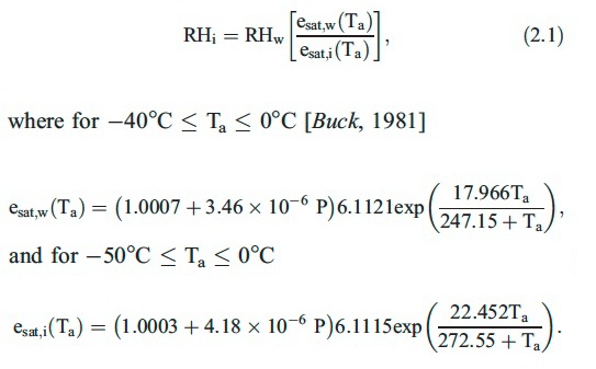
I've been observing planes leaving persistent spreading contrails at altitudes between 12,000 & 16,000 ft (ADS-B) with a RHw of 9% and a temperature of -14 degree celsius (Global Forecast System via - www.earth.nullschool.net). As far as I understand, for a contrail to persist and spread the environment needs to be ice super-saturated. I have been told that a RHw of 60 - 70% is roughly 100% RHi. Is this right (as earth.nullschool.net RH is with regards to water) I would like to convert this to RHi ( so I can substantiate the environmental conditions required for the contrails persistence and spread)
I understand that conditions can change rapidly,( and without having localised instuments available to report data) how far off the mark could the GFS be in regards to using a program like earth.nullschool.net/GFS data be?
I live in Victoria, Australia, the planes I speak of are leaving Tullamarine Melbourne, and heading to Launceston, Tasmania. Usually the contrails produced are persist and spreading (4-5+ hrs) leaving tullamarine and reaching crusing altitude, or leaving Launceston and coming in for landing at Tullamarine.
Thanks,
Matt

