Alleged Flight MH370 UFO Teleportation Videos [Hoax]

Not sure whether anyone tried this by now, but if I (as a layperson in VFX!) had the drive to produce these videos, I'd probably attempt to create the whole scene in a flight simulation (including the orbs), and then I could probably figure out how to produce matching videos from any angle, including a stereoscopic one.

It's not done in a half day, but at least the flightsim stuff isn't rocket science (ha ha).
 
This is a good hypothesis, and simpler than applying a single depth map to everything. So it would be: apply a shear to the background, then take the the clouds and aircraft and shift them a consistent amount.
Neither is simple.

If you have monocular footage, and apply a "depth map" or, which is the same thing, shear parts of the image but not others, you're going to "uncover" pixels that aren't there in the monocular footage, and that need to be filled somehow. Unless, of course, you always shear complete horizontal rows.
 
@cptreynolds yeah i proposed this as well. my approach would have been to record the flight (plane clouds, maybe even the drone view) in FSX. you can review a recorded flight from multiple views, so that would explain both videos.

then import this recording into after effects or similar software, add the "orbs" and let them motion track the plane. then add the blob effect. thermal vision is also doable, its a standard feature. you would just have to do some manual corrections.

job done within a very reasonable time frame and without the need of having way above average skills.

i used to have after effects several years ago but now its way too expensive to just play around for this purpose (unfortunately).

maybe i can find someone on fiverr (maybe someone in this forum?) who has after effects and flight simulator.
 
This is a good hypothesis, and simpler than applying a single depth map to everything. So it would be: apply a shear to the background, then take the the clouds and aircraft and shift them a consistent amount.

This wouldn't explain the inconsistency in the disparity of the aircraft though. For the first 40 seconds the disparity is larger, then it's very small until the flash. To explain this, we would have to assume that the animator accidentally keyframed a shift to the plane/clouds overlay around 40 seconds in. But this would be inconsistent with the fact that the clouds tend to have similar disparity throughout the video.

So this implies the animator would have had one shearing for the ocean, then a shearing + offset for the clouds, and a shearing + offset for the aircraft that accidentally got bumped around 40 seconds. Complex, but doable. I do feel like we are getting close to just acknowledging that the depth is complex enough to arguably be a real depth map, and it would be great to get any interferometric imagery of clouds + oceans for testing this. Maybe we can find something declassified.

Instead of going through all this work in post, I think it would be much easier to export a real depth map from the same 3D render that produced the thermal video and apply that. But in that scenario, why not just render the scene from two unique perspectives?


Check out the video I link to after the picture, the clouds also pop out to varying degrees over the course of the video. I just picked a still frame that didn't have many clouds (though you can still see one, at the bottom right).
So, thanks for taking the time to actually try to get a disparity map out of these images!
In my experience, I've found that disparity images are notoriously difficult to understand by eye, and its very easy to fool yourself into thinking they're ok when they're just noise. In particular, these maps look oddly smooth to me; I would expect to see blobs of disparity in areas with lower texture inside objects, with clear boundaries in the disparity map where occlusions occurred. You can see this in the classic stereo examples from textbooks:
1692229417720.png
(source)
In this case, I would expect the clouds to occlude the sea, which should produce clear boundaries. Based on your maps, either there really are no occlusions, or the block matching algorithm is overtuned to blur those bits out, or it's simply matching noise patterns or a warped image.

Often, it can be easier to understand disparity by converting it into a point cloud. Doing so requires knowing an intrinsic and extrinsic calibration of the two cameras. As we don't know this, we could make a guess based on the size of the airplane in pixels, and then fake the offset between the two cameras based on a triangulation formula which makes the disparity of the plane in pixels consistent with its size in meters. Now, the actual size doesn't matter (we don't care about the actual scale of the 3d points, just their relative structure), but it would be good to get a guess. Once we do that, we can produce a dense point cloud of the full image. If the disparity is real, you'd see structure corresponding to the actual clouds, the plane, and so on, otherwise, you will see garbage or possibly just a sheared plane.

Here would be the starting point for doing that in opencv (https://docs.opencv.org/2.4/modules...and_3d_reconstruction.html#reprojectimageto3d), again you will need to guess that Q matrix, which having uncalibrated cameras will be hard. Maybe later when I have the time I can poke at this.
 
More plane footage from confirmed satellite. Planes are in the tarmac, but at least we know what they'd look like shading/detail-wise. These are from SkySat.
Russian airport, black and white:
Source: https://www.youtube.com/watch?v=fwBlNpTEOkw

Mumbai airport color:
Source: https://www.youtube.com/watch?v=IXhoOFDeIJo


Loads of airplane footage in Earth-i: https://www.youtube.com/@EarthiLtd/videos

Notes:
  • At slant angles of filming, the camera speed of the passing satellite is Huge, notable, across many videos.
    • We should expect to see it in the ufo footage since it seems captured at slanted angle?
  • At an overhead angle, the camera speed is negligible in short video lengths (<10 seconds) (see Mumbai airport).
    • However, there appear to be obvious artifacts in other videos where the image appears to be adjusted (example)
  • Inconsistent framerate in SkySat. EDIT: Framerate is very low in Earth-i videos, my guesstimate from speed of vehicles inbetween frames in a straight line is likely at 1fps or even lower.
    • Does this mean the ufo footage is too high-framerate for it to be civilian sat footage?
EDIT:
  • Civilian color satellite video doesn't seem to have been available before 2018 by Earth-i's claims. For example, SkySat-1 was black and white
 
Last edited:
This is a good idea. I think people are loosing the forest from the trees on this and getting way too complicated to debunk something that just looks fake and cheap on the surface.

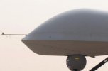
This simple, straight forward, analysis by u/Alex-Winter-78 on reddit noting the similarities between the "wire frame" curvature of the drone's nose in the UAV video with a cheap cgi model of a predator resonates in a way that all the complicated math doesn't, partly because it's so obvious that it's kind of shocking no one has done it yet:
Now wait for the pivot to "the thermal video is a deliberately bad hoax made to discredit the REAL satellite video".
 
Hello I'd like to share some potentially new information:

-Flight MH370 disappeared on March 8, 2014

-"RegicideAnon" posted one of the infamous videos to YouTube on May 19, 2014 link to archive
-"AreaAlienware" posted a better version of the video to Vimeo in August of 2014 link to video

Arguments have been made that given the time between the disappearance and video releases, VFX artists may have been able to create a fake.

I have identified a potential earlier source of the video. "Dual Gamma" posted what may have been the same video titled "UFOs with Vortex as Malaysia Airlines Flight MH370 Vanishes from Radar" on March 10, 2014, just 2 days after the disappearance. Here is the link to the archived version. Unfortunately the video is not archived but check it out for yourself. Appears to have been the same video in question.

If this video was uploaded only 2 days after the disappearance, likelihood of a vfx fake is decreased.

I think the full description does not match what we see in the video (my emphasis):
Malaysia Airlines Flight MH370 Vanished from Radar as the plane flew from Malaysia to Beijing, China. Meanwhile, in this new undisclosed video footage 2 UFOs were seen alongside a giant ring vortex, increasing its size in a logarithmic pattern to an apparent connection with the so-called Hyperdimensional Grid network predicted by some people in the field of planetary geometrics and portal energy fields.
Did the plane encounter the UFOs? Did the plane enter another dimension? Is this the sign of a magnetic polar shift or an electromagnetic disturbance? Could this be induced by the United States new mobile HAARP platform technology?
Or is this just some weather formation and is the government of China and the West using the conspiracies and lack of information as a cover for terrorism. Is the mass media using this as a way to implement the Illuminati's plan of a fake alien invasion?

You be the judge.

But this does illustrate that people were immediately peddling fake videos on the theme of UFOs and mysterious portals being the cause of MH370’s vanishing.
 
Last edited:
Excerpting @V0LDY's megapost for visibility (and embedding the images):
TL;DR: the video can't be real because of satellite imaging limits (don't just pick this quote and show me hyper detailed ground imaging as counterargument, I'll address it in the detailed explaination), I'll give other additional clues for why it probably is fake, but the main reason is just that you can't get that quality out of satellite images operating at the geostationary altitude, the only one that could (partially) explain still clouds and lack of parallax movement.
First of all it's as screengrab, the original video seems kinda low resolution on his own, and so is the recording, it's the oldest trick in the book if you want to hide editing flaws and make the analysis harder.
Let's get to the hot part now: camera tech.

It's super weird that a spy satellite would provide full color VIDEOS (important that it's a video, not a still image), because a sensor capable of capturing color images implies you are sacrificing a lot of resolution and signal to noise ratio, both things that are crucial if you're interested in achieving the highest quality imaging of small details, and the reason every single space telescope that I'm aware of operates with monochromatic cameras. Remember Trump's leaked satellite photo? That was monochromatic for a good reason!
The look of the image is weird aswell, it doesn't seem to be footage from a satellite, which is usually much cleaner and with better resolution (at least for the imaging scale of the satellite), while here it looks like an video from a normal camera), but again that's just swamped by the compression and screengrab artifacts so it can't be judged properly (starting to see a pattern here, uh?).


Another odd clue: when the planes blinks into oblivion we see a bright flash, and what is weird is that we don't see a clear diffraction spike nor any internal lens reflection artifact or loss of contrast, all things that happen when you photograph a bright light with a mirror telescope (and that's the only possible way to build a large space telescope). Just google "telescope diffraction spike", you'll see what I mean.
Diffraction limit.

What is diffraction limit? Essentially how detailed of an image an optical system can produce given it's aperture (in this case how wide the mirror is) and operating wavelength, and that's the absolute best scenario not counting loss of contrast from mechanical diffraction (ie caused by the mirror's support structure), loss of resolution from the sensor (especially in this case where it's a color sensor!), atmosphere, movement of the craft, etc.

This is an hard limit. You simply can't break it regardless of how advanced you think NRO tech is, definitely not without image processing via stacking, doconvolution, drizzle, etc, but it's all stuff you simply can't do in a video.

How can you calculate the diffraction limit?

Just use this tool https://www.omnicalculator.com/physics/angular-resolution
How high was the satellite? Very high. Proof? There is absolutely ZERO parallax shift in the clouds compared to whatever's underneath (regardless of them being smaller clouds or waves as someone suggested) or between the clouds themselves. There is just some slight movement (and over a minute, considering how fast windws are at that altitude, that's sus on his own) that could be some simple warp or actually even just some artifact due to the extreme video compression and artifacts, but asolutely nothing indicating parallax that would suggest that it's footage coming from a moving satellite.
So, it can't be a relatively low orbit satellite flying by, but could it be geostationary? Nope.
Let's make the calculations (again using 550nm as a visible light middle ground) and the altitude of 35.786km!

For a 250cm aperture telescope we get 0.0554 arcseconds of resolution, that transalte to a resolution of 9.6 meters. Definitely not enough for the footage we saw, remember each pixel in that video at 720p is 50cm, pretty much what you'd get if the WorldView 3 if it was a few hundreds km higher, but still in a MUCH lower orbit compared to what's implied here.

So that's it, video is impossible with REASONABLE assumptions.

But as I said, let's assume, irreasonably, that NRO is operating a 6.5m JWST like behemoth, what would its resolution be? We get 0.0213 arcseconds at 550nm, translated to geostationary that's 3.7 meters, again nowhere nearly enough resolving power for that footage, especially since that's the perfect scenario with a monochromatic camera, hence not even counting the loss of resolution from a color sensor or any other form of image degradation you'd get in the real world.

What is 100% sure is that no telescope in the SBIRS program (the one mentioned in the video text) has capabilities even remotely close to those of the HST/big spy scope, let alone to the JWST that still wouldn't be enough for a footage like this, and that's assuming those satellites even have optical imaging capabilities at all!
One last thing, always about clouds: google pictures of "clouds from satellite" and "clouds from plane", see for yourself which one resembles more the ones seen in the video, which would reinforce my hypotheis that what we're seeing is just a 2d photo of clouds photo on which the plane was composited on.
gettyimages-1503418106-2048x2048.jpg
This one in particular is not the same image but looks extremely similar, even with the small white dots that aren't moving in the video, just apply a curve regulation to clip the white a bit and it looks exactly the same kind of photo!
gettyimages-1186044529-2048x2048.jpg
 
Hello I'd like to share some potentially new information:

-Flight MH370 disappeared on March 8, 2014

-"RegicideAnon" posted one of the infamous videos to YouTube on May 19, 2014 link to archive
-"AreaAlienware" posted a better version of the video to Vimeo in August of 2014 link to video

Arguments have been made that given the time between the disappearance and video releases, VFX artists may have been able to create a fake.

I have identified a potential earlier source of the video. "Dual Gamma" posted what may have been the same video titled "UFOs with Vortex as Malaysia Airlines Flight MH370 Vanishes from Radar" on March 10, 2014, just 2 days after the disappearance. Here is the link to the archived version. Unfortunately the video is not archived but check it out for yourself. Appears to have been the same video in question.

If this video was uploaded only 2 days after the disappearance, likelihood of a vfx fake is decreased.
Interesting info thanks for sharing! It was actually already receiving coverage on March 6th US/ET (March 7th MYT) on the day of the disappearance. My understanding is the official statement that it was considered crashed is what came on the 8th.

Article:
Malaysia Airlines Flight Vanishes, Three Americans on Board
Last radar location in the South China Sea.
By GLORIA RIVIERA
March 6, 2014, 6:49 PM

It's unfortunate the video wasn't archived because we can only make assumptions about the content and as @Max Phalange pointed out the description is slightly different. Since we have no further information about the video one hypothesis is as good as another. Maybe the hoaxers did an earlier trial run and decided the result wasn't up to snuff and made a better version, or maybe whoever made the video we have was inspired by the earlier video. Whatever the case, it is an interesting data point that a potentially similar video was posted earlier.

It is definitely not the same video or related. The description describes that the video shows two separate events, and asks if the viewer thinks MH370 could have encountered something similar.


I wanted to share I am in contact with one of the only other people who is supposed to have received an original copy from the same anonymous source RegicideAnon did. I am going to attempt to get his side of the story, a clean copy of the videos, any of the email conversation with the original leaker, etc. So far they have only confirmed in writing they have received my email and assured me they will respond in full soon. Hopefully they can share some level of insight we haven't already gotten from our own investigation.

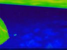
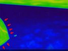
Regardless of that, I believe this is a clincher for the authenticity of the video and would like all of you opinions. Hard straight lines are visible on the nose of the UAV, when there should be nothing of the sort on the real MQ-1C.

I would also like to raise the issue of the positioning of the sensor pod. I believe it it much too high in the video, further proving a fake. On the real MQ-1C with a sensor pod mounted under the wing, the view looks significantly lower than what we see in the video. I believe whoever made this, or whatever CGI drone asset they used, incorrectly positioned the view of the thermal camera much too high. This completely disregards the mounting bracket and the housing for the sensor itself.


Source: https://old.reddit.com/r/UFOs/comments/15t4yb8/the_mh370_video_is_cgi/

Isolating the green channel further emphasizes the hard lines: https://i.imgur.com/g5IlQQM.png
 
Last edited:
Interesting info thanks for sharing! It was actually already receiving coverage on March 6th US/ET (March 7th MYT) on the day of the disappearance. My understanding is the official statement that it was considered crashed is what came on the 8th.

Article:
Malaysia Airlines Flight Vanishes, Three Americans on Board
Last radar location in the South China Sea.
By GLORIA RIVIERA
March 6, 2014, 6:49 PM
That's March 6, 2014, 23:49 UTC.
Considering that MH370 took off a day later, there seems to be a problem with the date given.

Compare:
SmartSelect_20230817-025053_Samsung Notes.jpg
 
fake the offset between the two cameras based on a triangulation formula which makes the disparity of the plane in pixels consistent with its size in meters. Now, the actual size doesn't matter (we don't care about the actual scale of the 3d points, just their relative structure), but it would be good to get a guess. Once we do that, we can produce a dense point cloud of the full image.
Because these are effectively orthographic cameras, it should be simpler: we can just take the inverse of disparity to get a scaled depth value.

I saw someone render a point cloud from a single frame over on Reddit, and it showed some clouds popping out a little. I think to do it properly the depth map should be applied to the video over time instead of just rendering a single frame. The disparity is so small I wouldn't be surprised if we're mostly seeing artifacts from the StereoSGBM algorithm. That's why I think it's better to focus on analyzing disparity across all the pairs, then subtracting the pattern, and checking visually if anything useful is leftover.
 
Excerpting for visibility:
- 'NROL-22' was the launch number, the satellite is 'USA-184' why would any footage be watermarked with the launch number, not the actual asset id
I've looked at a lot of NRO-sat footage and see no watermarking, launch or satellite number..

Aside from all this, the idea that some group covered this alleged event up by replicating pieces of fuselage debris etc. and scattered them throughout the Indian Ocean to wash up on beaches, is completely absurd and would require a monumental effort to carry out, not to mention that all efforts by all groups to identify them as MH-370 would have to be part of the conspiracy (including - based on the (Aviation Safety Report) entries for debris analysis -

• the French Judicial Authority - [...]

• the ATSB Laboratory in Canberra - many of the pieces were examined by this group

• "the Team" (in Malaysia) - most of the pieces were examined by this group

• "the Team" in collaboration with Science & Technology Research Institute for Defence (STRIDE) [...]

• The South African Civil Aviation Authority - [...]
 

Attachments

  • p5ifiqc8vjib1.jpg
    p5ifiqc8vjib1.jpg
    12.7 KB · Views: 39
  • o10asauwqjib1.jpg
    o10asauwqjib1.jpg
    20.1 KB · Views: 44
  • 4nkhdaz3rjib1.jpg
    4nkhdaz3rjib1.jpg
    21.5 KB · Views: 38
That these are 3D models can be seen at the very beginning of the video , where part of the drone fuselage can be seen.
Content from External Source
Someone else claimed this could be a camera artifact for foreground out-of-focus objects. That doesn't make intuitive sense to me but I don't know enough about cameras, especially IR cameras, to believe or disbelieve
 
Someone else claimed this could be a camera artifact for foreground out-of-focus objects. That doesn't make intuitive sense to me but I don't know enough about cameras, especially IR cameras, to believe or disbelieve
If they don't have any evidence (read: example shots showing the effect), your reaction should be strong doubt.

I know of no optical principle that would introduce corners where they were none; the blurring from being out of focus would rather tend to round contours more.

[Edit: sprinkled some bold type]
 
Last edited:
Someone else claimed this could be a camera artifact for foreground out-of-focus objects. That doesn't make intuitive sense to me but I don't know enough about cameras, especially IR cameras, to believe or disbelieve
It has been pointed out previously in this thread that the camera is mounted underneath the "nose" of a real mq1 so it would not be able to capture itself like that.

Edit: Pic
1692235735928.png
https://upload.wikimedia.org/wikipedia/commons/thumb/4/4a/MQ-1_Predator.jpg/640px-MQ-1_Predator.jpg
 
If they don't have any evidence (read: example shots showing the effect), your reaction should be strong doubt.

I know of no optical principle that would introduce corners were they were none; the blurring from being out of focus would rather tend to round contours more.
It has been pointed out previously in this thread that the camera is mounted underneath the "nose" of a real mq1 so it would not be able to capture itself like that.
This seems like case closed then, no? These two simple observations totally debunk the entire thing. The drone video, at least.
 
It has been pointed out previously in this thread that the camera is mounted underneath the "nose" of a real mq1 so it would not be able to capture itself like that.
The drone in the video has been confirmed to be an MQ-1C with an additional sensor pod mounted under its wing as seen here:
Source: https://www.flickr.com/photos/49896373@N06/6189724669/


This still does not explain the difference in height we see in this photo and the actual thermal videos view. It should be much lower(in my opinion, someone please confirm) if this sensor pod is mounted under the wing of a real MQ-1C. I believe the creator made a mistake in positioning the view of the camera, and it should be lower.

Note this picture also highlights that it may not be the underside of the wing we see at the top of the view, but instead the sensor pod housing clipping across the sensor as it struggles to look up and catch a view of MH370. You can see what I mean in the photo.

Semi-related... the WW2 video upload that was posted here also uploaded by RegicideAnon, does anyone else notice the very beginning of the clip when the 'gun-cam' is rotating... do we see directly through the 3D model airplane? I keep staring at that and trying to figure out what part of the plane I would be looking at, and to me it seems that I am looking directly through the body of the craft - like the camera is clipping through the CGI model. Only obvious the very first few frames when the camera is still turning. I don't have the time to get on every detail of every video, but its a detail that has been bothering me since I noticed it.
 
Last edited:
This seems like case closed then, no? These two simple observations totally debunk the entire thing. The drone video, at least.
I'm inclined to agree. My hat is off to whoever made this-they did a pretty good job of hiding the low quality asset with blur and noise, and they've kept totally silent about doing this for nearly 10 years. Really hope whoever it is comes forward, I'm curious why they'd spend so much time doing something like this.
 
If they don't have any evidence (read: example shots showing the effect), your reaction should be strong doubt.

I know of no optical principle that would introduce corners were they were none; the blurring from being out of focus would rather tend to round contours more.

[Edit: sprinkled some bold type]
Objects being out of focus won't necessarily round contours but it most definitely does not introduce previously non-existent corners so you're correct there
 
In the drone video the plane appears to clip in front of the reticle at ~16.20 seconds, it has a pretty chunky border around it. Working on making a gif, but if you zoom in on the top left reticle and move frame by frame it looks pretty clear.
 
r/UFOs likes to encourage posting in their MH370 megathread by removing related posts; this happened to you. Feel free to repost your analysis here.
Here's what I originally posted:

I'm a VFX artist who specialises in 2D compositing and I just learnt about the MH370 satellite video a couple hours ago (3am, when else) and have reason to believe it may have been achieved with VFX

Now I'm not saying it IS VFX, but there's evidence that it could be, the most compelling is that the light caused by the blip is achieved on a two dimensional level, something that CAN be achieved with 2D VFX.

I've included reference images to show this:

Screenshot_2023-08-17-03-57-50-982_com.google.android.youtube.jpg
Screenshot_2023-08-17-03-57-47-523_com.google.android.youtube.jpg
IMG_20230817_051614.jpg

The first image is the frame after the blip, the second; the blip, and the third is the same as the first one but I've increased the contrast.

This is to demonstrate that the light that has been effected by me changing the contrast is in a very similar shape and area to the light caused by the blip. I've zoomed in on these frames to better demonstrate but you'll notice in the full frame that the clouds on the left appear to also be affected by the light, yet the greyer area on the cloud directly beneath the plane is not affected by the light being emitted. This only really makes sense if this cloud is significantly taller than it is wide, and that grey area of the cloud is much further away from the plane than the other clouds. Also worth mentioning is there's no change in direction of any shadows cast by the cloud, all the light and shadows follow the same direction as they do for the rest of the video.

Let's say for the sake of argument that the clouds are very tall; we also have the contrails behind the plane. I'm no cloud scientist, but I do believe contrails reflect light, yet they don't seem to reflect any of the light emitted from the blip. This supports my theory of the light being achieved in 2D as the contrails aren't visible enough in the video to be affected by such effects as exposure or contrast, but I'd expect them to reflect and refract plenty of light. This could simply be an affect on the sensor of whatever camera this is by extra bright areas being added to frame, but I'm no camera expert so if someone is please let us know.

These next clues could be something or nothing, but I'd like to mention them anyway:

The next clue is the motion blur. There's not a lot of motion blur, but there is perceivable motion blur, and not what I'd expect from the contents of the video. The orbs around the plane do seemingly have horizontal motion blur from flying along side the plane, yet they seem to have no or very limited vertical motion blur from orbiting the plane. Those objects would have to be moving super fast to be able to keep up with the plane AND orbit around it, which you'd expect to show a diagonal or even slightly curved motion blur, yet what we mostly see is horizontal motion blur, the sort of motion blur that would be calculated via a point track of the plane, which only moves horizontally across frame. Either that; the orbs are oblong and orient themself to the camera the entire time (which is disproven by the thermal shot), or this video is stretched horizontally (which is likely, but I'd still expect more motion blur)

Now another, harder to explain clue, is the compression artifacts. All I can really say is that they're much smoother in the frame of the blip, which makes sense as they're more visible in darker areas, however there is still usually a consistency with compression artifacts that seemed to change drastically between the frames before and after the blip, implying a match-cut to footage from after the plane had left frame, perhaps? This isn't so much evidence, as it is something I noticed and thought worth mentioning.

The blip frame also moves a pixel or two compared to both frames either side of it which is suspicious but I'll give it the benefit of the doubt.


Now again, even though I've just rambled on, I'm not confident in saying it is VFX, I'm just saying it could be, and sharing what I noticed as a comp artist.

If anyone is something I'm not and has counterpoints please do share, I'm not emotionally attached to this theory.

Personally, I hope it's aliens cause that shit excites me.
 
On the real MQ-1C with a sensor pod mounted under the wing, the view looks significantly lower than what we see in the video: https://i0.wp.com/www.defensemedian.../09/Triclops-on-Gray-Eagle-SG.jpg?w=800&ssl=1
Tip: Save the image; then use the "Attach files" button from the editor to upload the image to Metabunk; click on the icon for the attached image to insert it into your post at the cursor position. (Check the "Link policy" under "Info" in the site navigation for why to do this.)
 
The drone in the video has been confirmed to be an MQ-1C with an additional sensor pod mounted under its wing as seen here:
Source: https://www.flickr.com/photos/49896373@N06/6189724669/


This still does not explain the difference in height we see in this photo and the actual thermal videos view. It should be much lower(in my opinion, someone please confirm) if this sensor pod is mounted under the wing of a real MQ-1C. I believe the creator made a mistake in positioning the view of the camera, and it should be lower.

Note this picture also highlights that it may not be the underside of the wing we see at the top of the view, but instead the sensor pod housing clipping across the sensor as it struggles to look up and catch a view of MH370. You can see what I mean in the photo.

Semi-related... the WW2 video upload that was posted here also uploaded by RegicideAnon, does anyone else notice the very beginning of the clip when the 'gun-cam' is rotating... do we see directly through the 3D model airplane? I keep staring at that and trying to figure out what part of the plane I would be looking at, and to me it seems that I am looking directly through the body of the craft - like the camera is clipping through the CGI model. Only obvious the very first few frames when the camera is still turning. I don't have the time to get on every detail of every video, but its a detail that has been bothering me since I noticed it.

That seems plausible as what it was based on, and it looks like this type of drone was known about a good few years before the video was released-I wonder if we can find and line up the exact model used in the video and get one to one correspondence to the angles of the polygons.
 
Who confirmed it?
Maybe a much better way for me to say it is, the only drone it could have possibly been at the time is an MQ-1C, or some other unknown/classified/made-up in cgi drone. There isn't another model in service in 2014 with the ability to mount a sensor pod under the wing, so it was deduced rather than confirmed.
 
Tip: Save the image; then use the "Attach files" button from the editor to upload the image to Metabunk; click on the icon for the attached image to insert it into your post at the cursor position. (Check the "Link policy" under "Info" in the site navigation for why to do this.)
Also on modern browsers you can usually even skip the download step, you can usually right-click the image and choose "Copy Image" and then ctrl-v (or right-click -> "Paste") in the reply textbox. MB will automatically upload it from the clipboard as an attachment and insert it at the cursor. Some sites disable right-click or have a dummy image on top of the real one and such, but it generally works.
 
Someone could have had a fun UFO abducts plane CGI video ready to go in the portfolio and then just added coordinates and a real satellite that matched later on in an overlay.

If that is a pod mounted camera on the wing of a drone as pictured the angle it looks a little odd to have a wing and that angle, if could get a drone model I could mess with camera positions in Blender to see if it makes sense.
 
If that is a pod mounted camera on the wing of a drone as pictured the angle it looks a little odd to have a wing and that angle, if could get a drone model I could mess with camera positions in Blender to see if it makes sense.

Source: https://www.reddit.com/r/UFOs/comments/15p6aps/simulating_the_mq1_camera_pose/


Someone said they tried it but there attempt looks flawed to me, incorrect drone model (as per the claims) and they never show a good external view of where they positioned the camera.
 
I feel for the people that lost loved ones on MH370 and come across this on twitter etc.
I agree this whole thing is in poor taste, I feel bad participating in the debunk.

I think if the person that created this CGI is out there, at this point they should come forward with any evidence to show they created it to save the families of the victims of this tragedy more trauma as it hits the media more.
 
Back
Top