You are using an out of date browser. It may not display this or other websites correctly.
You should upgrade or use an alternative browser.
You should upgrade or use an alternative browser.
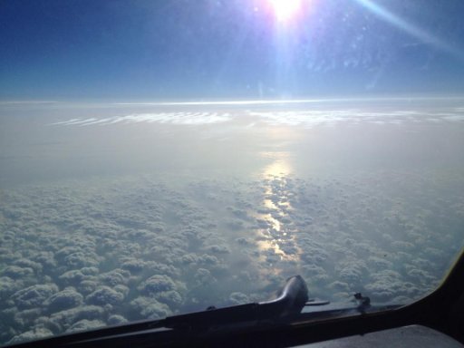
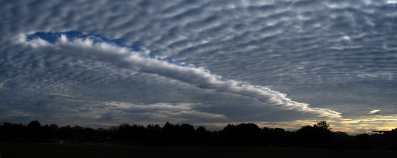
A Cloud Highway? [Canal Cloud over the Gulf of Oman]
- Thread starter KC-10FE
- Start date
A cloud highway?

Very nice, l don't suppose you know what altitude this was at? Clouds don't look like contrail altitude, so I'm wonder how it was formed - maybe just the downwash stirring up?
scombrid
Senior Member.
Well it is a very flat layer of stratiform water clouds. Looks like the top of a marine layer. Would love to know the altitude.
The super-straightness of the feature is interesting. Fairly light unidirections wind in that layer and something was travelling straight upwind or downwind I suppose. So was it the turbulent wake that altered the cloud? Was it a change in particle/droplet size in response to particulates in the exhaust as in a ship track? What do ship tracks look like viewed from an airplane? I've only seen satellite images.
The super-straightness of the feature is interesting. Fairly light unidirections wind in that layer and something was travelling straight upwind or downwind I suppose. So was it the turbulent wake that altered the cloud? Was it a change in particle/droplet size in response to particulates in the exhaust as in a ship track? What do ship tracks look like viewed from an airplane? I've only seen satellite images.
Well it is a very flat layer of stratiform water clouds. Looks like the top of a marine layer. Would love to know the altitude.
The super-straightness of the feature is interesting. Fairly light unidirections wind in that layer and something was travelling straight upwind or downwind I suppose.
It just needs unidirectional winds to be straight. Does not matter what directions the plane/ship is going in.
So was it the turbulent wake that altered the cloud? Was it a change in particle/droplet size in response to particulates in the exhaust as in a ship track? What do ship tracks look like viewed from an airplane? I've only seen satellite images.
Ship tracks/trails sounds plausible. But I also can only find satellite images.
Here's a trail in a cloud layer, hard to see from above (and at around noon, so overhead sun), but might be more apparent with the right lighting.
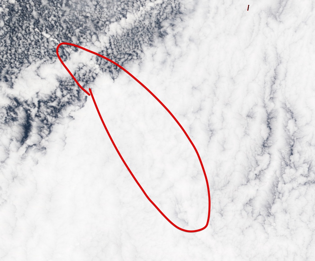
scombrid
Senior Member.
I wonder if the following article has any accompanying photos. I can only get the abstract here.
Science 1 December 1989:
Vol. 246 no. 4934 pp. 1146-1149
DOI: 10.1126/science.246.4934.1146
Direct and Remote Sensing Observations of the Effects of Ships on Clouds
- Reports
+ Author Affiliations
Under certain conditions ships can affect the structure of shallow layer clouds. Simultaneous observations of two ship track signatures in stratus clouds from a satellite and in situ from an aircraft show that in the ship tracks the droplet sizes were reduced and total concentrations of both droplets and particles were substantially increased from those in adjacent clouds. In situ measurements of the upwelling radiance within the ship tracks was significantly enhanced at visible wavelengths, whereas radiance at 2.2 micrometers was significantly reduced. Cloud reflectivity along the tracks was enhanced at 0.63 and 3.7 micrometers. These observations support the contention that ship track signatures in clouds are produced primarily by particles emitted from ships.
- 1Department of Atmospheric Sciences, University of Washington, Seattle, WA 98195.
- 2Department of Atmospheric Sciences, Oregon State University, Corvallis, OR 97331.
- 3Laboratory for Atmospheres, National Aeronautics and Space Administration, Goddard Space Flight Center, Greenbelt, MD 20771.
Last edited by a moderator:
KC-10FE
Senior Member.
Very nice, l don't suppose you know what altitude this was at? Clouds don't look like contrail altitude, so I'm wonder how it was formed - maybe just the downwash stirring up?
The first two pictures were at FL280, coming in over the Gulf of Oman, and the last one was cruising out at FL250. I should have clarified, the first 2 picture were of "highway" the 3rd picture [now below] was in the morning, just of the different clouds.
Last edited by a moderator:
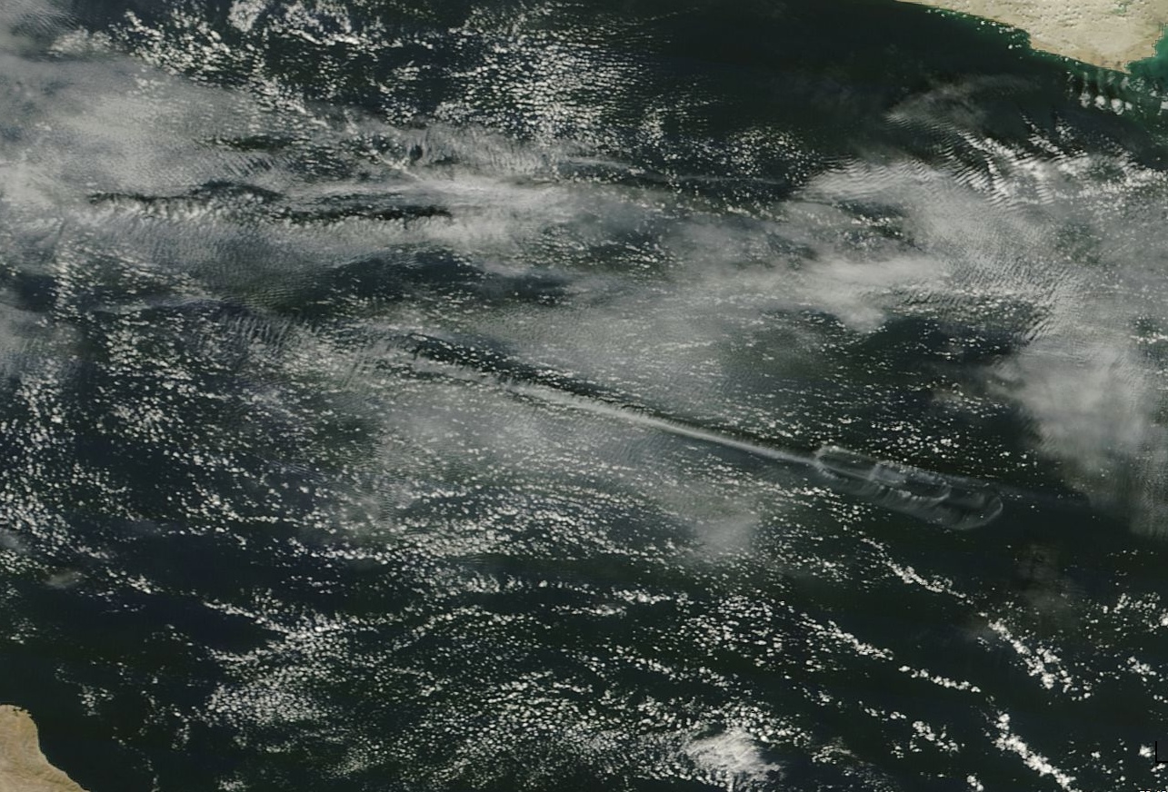
Gulf of Oman today (March 4 2014):
https://earthdata.nasa.gov/labs/wor...04&map=41.762939,14.86084,72.348877,33.722168
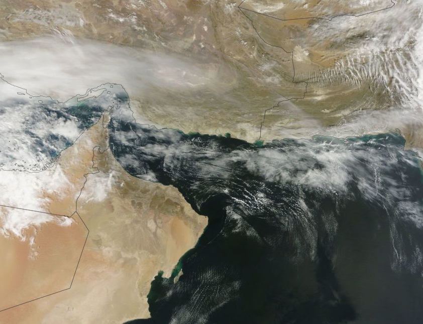
Was it "today", March 4th? Oman is 12 hours ahead, so seems plausible.
The angle of the track relative to the ripples looks right (i.e. it's at right angles to them), and they would look denser from the low angle.
https://earthdata.nasa.gov/labs/wor...04&map=41.762939,14.86084,72.348877,33.722168


Was it "today", March 4th? Oman is 12 hours ahead, so seems plausible.
The angle of the track relative to the ripples looks right (i.e. it's at right angles to them), and they would look denser from the low angle.
Last edited:
WeedWhacker
Senior Member
Gulf of Oman today (March 4 2014):
Ya know, those great satellite images are perfect for what I sometimes try to explain to people who believe in the 'chem"trail myth. I often will suggest that they take time to review any and all that they can find, and to compare to any going back decades, to see that there really is no appreciable change in the percentage of cloud coverage, globally.
Of course, this suggestion usually either falls on deaf ears...or, those I suggest it to never reply (perhaps out of embarrassment?), so I get no actual feedback.
NASA Worldview is endlessly fascinating. Just scrolling and zooming around today's image is incredible.
https://earthdata.nasa.gov/labs/wor...ap=-126.979126,27.34314,-111.686157,36.773804
deirdre
Senior Member.
can you change the time? or did you just get lucky?NASA Worldview is endlessly fascinating. Just scrolling and zooming around today's image is incredible.
https://earthdata.nasa.gov/labs/wor...ap=-126.979126,27.34314,-111.686157,36.773804
can you change the time? or did you just get lucky?
There are two satellites, they (basically) both take one picture of every spot on the Earth around noon. So you have to get lucky.
KC-10FE
Senior Member.
Gulf of Oman today (March 4 2014):
https://earthdata.nasa.gov/labs/wor...04&map=41.762939,14.86084,72.348877,33.722168
Was it "today", March 4th? Oman is 12 hours ahead, so seems plausible.
The angle of the track relative to the ripples looks right (i.e. it's at right angles to them), and they would look denser from the low angle.
Yep, I forgot I am about 9 hours ahead of EST, so that checks, wow what a picture! It was on the 4th about 1130 our time. We were on an airway, which does have quite a bit of traffic heading into Dubai/Abu Dhabi
Yep, I forgot I am about 9 hours ahead of EST, so that checks, wow what a picture! It was on the 4th about 1130 our time. We were on an airway, which does have quite a bit of traffic heading into Dubai/Abu Dhabi
Cool, so it seems like what you are seeing is a "canal cloud" (essentially a long fallstreak hole), viewed from a very acute angle, and at a fairly early stage in development. From below, a bit later, it would look like:
http://www.wunderground.com/wximage/walcek/250?gallery=
The description the above image:
Being in warmer climes, your altocumulus deck would be a bit higher.This cloud deck, at just under 10000 feet and 2 degrees C ABOVE freezing shows evidence of an aircraft flying ABOVE it, and the downwash mixing dry air into the cloud, triggering "Cloud Top Entrainment" instability: an unstable evaporation cycle
Very cool image, and quite unusual!
Similar threads
- Replies
- 21
- Views
- 1K
- Replies
- 7
- Views
- 1K
- Replies
- 8
- Views
- 611
- Replies
- 101
- Views
- 18K

