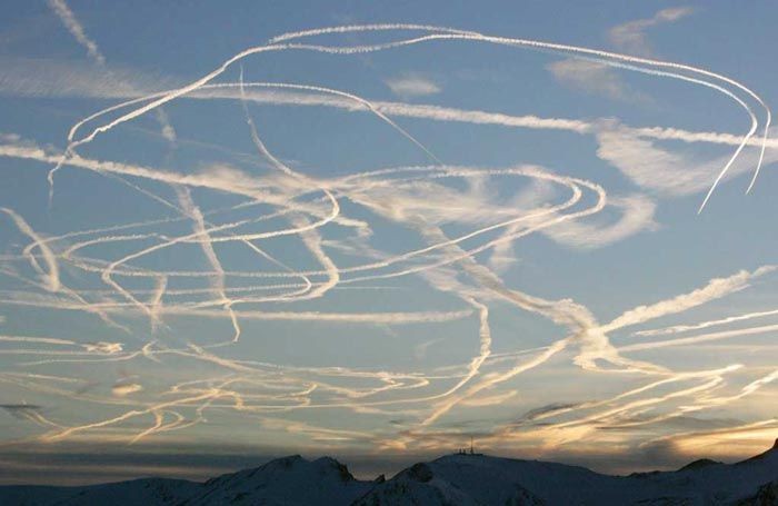
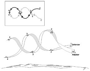
Investigated: W-shaped contrail near Central California Coast

Trailspotter

Senior Member.
KSBY_W-contrail.jpg

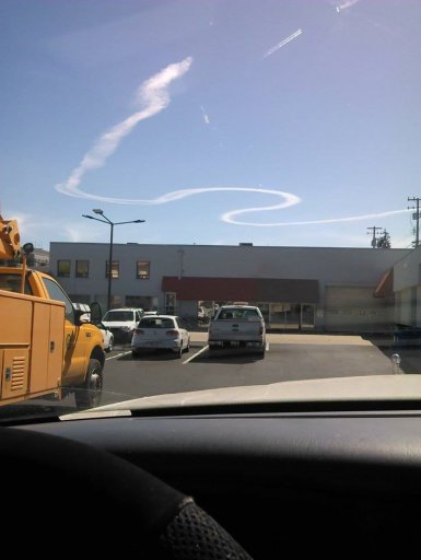
This W-shaped contrail was seen on 23rd June 2014 in San Luis Obispo county and beyond. There are many pictures from different locations in the comments to the KSBY FB photo:

https://www.facebook.com/ksbynews/p...1405317781./10152959624733709/?type=3&theater

and a few more found in blogs, newsletters and flickr:
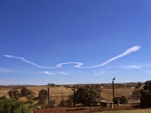
IMG_0929.JPG
http://hotflashhomestead.blogspot.co.uk/2014/06/spirit-in-sky.html#comment-form
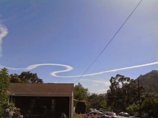
SLO chemtrail.jpg
http://mathisencorollary.blogspot.co.uk/2014/06/a-new-theory-on-chemtrails-proposed-by.html
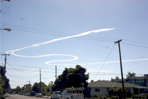
Arroyo Grande.png
https://www.flickr.com/photos/fletchergravy/14493454605/

The time stamps, where available, suggest that contrail was formed a short time before 16:00 PDT (23:00 UTC) and persisted for at least 40 minutes after that time.

For a while I have been trespassing in the Mick's back yard, trying to identify a likely culprit.
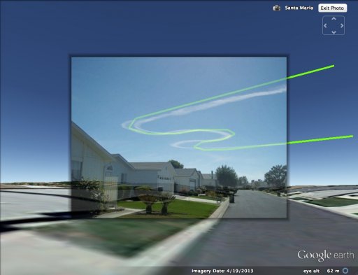
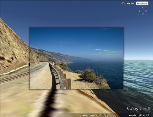
I have started with searching for the camera locations and pinpointed some of them to a few metres on the ground. I added these images to Google Earth and modelled the contrail positions by trial and error.
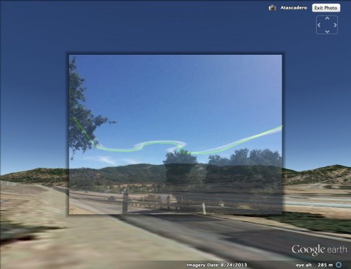
Atascadero fit.jpg Santa Maria fit.jpg Big Sur fit.jpg

Although I have not succeeded in my ultimate goal, I have ruled out all planes that have been flying at the time in this general area and appeared on the FR24 playback, including NASA502 and NASA817. I have determined probable altitude and initial location of the trail as well as its orientation and movement across the sky with the wind.
SLO W-contrail tracking.jpg

The contrail was formed at a high altitude of about 39,000 ft over the ocean west of Diablo Canyon Power Plant and carried by a WSW wind toward Vandenberg Air Force Base.

The satellite photographs of the day show a layer of marine clouds along the California Coast, but no clouds or persistent contrails over the land. In the Terra image taken at 18:55 UTC, there is a long young contrail casting shadow on the cloud layer in the Monterey Bay area. FR24 playback has identified this contrail being from SIA12 flight NRT -> LAX, the altitude of which was 39,000 ft.
SIA12 contrail.jpg
It is very likely that favourable atmospheric conditions for persistent contrails at this altitude extended farther south along the coast but not to the land. There are some older contrails southwest of Santa Barbara Channel blending in with the cloud layer.

Due to a high altitude of the contrail it was photographed from as far north as Big Sur in Monterey county and as far south as Summerland near Santa Barbara, the two locations being 170 miles apart. The Big Sur photo shows clearly the contrail location being above the ocean and a cloud bank.
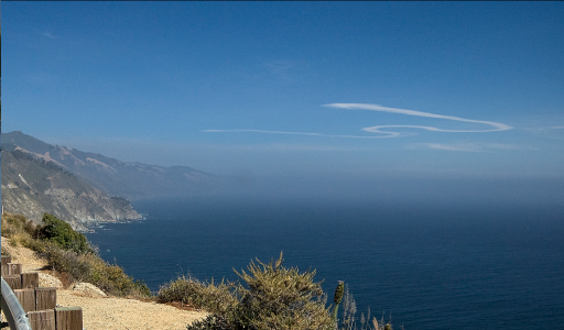
Big Sur crop.png
https://www.flickr.com/photos/wchristine/14430751547/

The title photo from the KSBY FB page is probably the earliest available image of this contrail showing it having two strands in several regions. In most other images these strands have merged together apart of one turn where their separation appeared to have increased. The KSBY photo probably has been taken from the air; its camera location has been identified with less precision to a place north of Shell Beach facing west toward Diablo Canyon. This is in an agreement with the location that has been derived from a ground photo with a smaller contrail image of about the same age. Its location has been modelled with red line (see above the GE image with a map of this area).

The latest time stamp (16:38) belongs to the image taken at Summerland:
Contrail1.6.23.jpg

http://slo.edhat.com/site/tidbit.cfm?nid=136285

By that time the contrail was quite aged and 'landed' above Vandenberg. This location has been modelled in magenta. Other contrail images were mapped to intermediate locations between the red and magenta model contrails. These locations have been modelled in intermediate rainbow colours. The average location (in green) has been modelled in more details with the younger looking contrails being to the west of it and older looking ones to the east of it, respectively. All assigned photos and fitted contrails are in the attached kmz file

FR24 playback showed no recorded flights in the area where this contrail was formed. The closest flight was NASA502 that made a few turns near Vandenberg at a later time. The area itself lays aside of the commercial air traffic routes going along the West Coast and across Pacific. I have found no information regarding whether this area is a restricted airspace / designated military training area or not, yet it seems likely that the contrail was left by military aircraft. The long arms of W-shaped trail point in NE direction, suggesting that the aircraft may well have come from NAS Lemoore or Travis AFB. Unfortunately, I am not in position to explore this possibility further. Perhaps, some of the locals could help me here.

EDIT: It was pointed by Trigger Hippie below (#19):
That whole area west of the Diablo Canyon Power plant seems to be reserved military airspace with an unlimited ceiling limit.

http://vfrmap.com/?type=vfrc&lat=35.237&lon=-120.643&zoom=10


There is one more unanswered question: how many planes have made this contrail?

The original post on the KSBY FB page suggests it was made by two jets:
External Quote:
Dave Hovde: Nice pic of the contrails from a pair of jets flying over the Central Coast. Post yours as well.
If this is correct, the two jets must have flown in a tight formation for more that 80 miles (the contrail estimated length). However, it seems equally possible to me that the contrail was made by a single large plane with two or four engines attached to the wing. Is there a way to distinguish between the two possibilities?
 

Attachments

Last edited:
I guess Deidre has another letter to add to her collection. Might use it as an M also. At least I think that's what she was alluding to?
 
Last edited:
this guys photo looks like another contrail to top? which is definitely a plane I think. not sure if that helps anything.

View attachment 8513 https://www.facebook.com/photo.php?fbid=908768455816329&set=p.908768455816329&type=1&theater


Similar to the OP. I dunno.....in MY experience as an airline pilot, I've had MANY occasions to have been radar-vectored by ATC....and, not "every" time was I producing a visible contrail.

THAT is the issue....rare occasions when a jet at high altitude "happens" to be forming a contrail "AND" is exhibiting a track, a flight track, that is a bit "unusual". THOSE tend to get "noticed". The other hundreds of instances, when there is NO CONTRAIL? Never brought up (of course).
 
what's that?

ATC = Air Traffic Control.

Sometimes en-route flights (when in radar contact, and being "controlled" by the supervising authority) can be told to go "off-route" by being assigned a specific magnetic heading to fly. THIS is a "radar-vector".

This is done for many reasons, and is actually quite common. Air Traffic Controllers have different "tools" at their disposal, and this is just one of them.

("Another edit"....and I hesitate to add this...but "In for a penny!"):
There is a major motion picture from 1999 titled "Pushing Tin". Like most of Hollywood, it has good points, and flaws. It 'might', though, help a lay-person to grasp how ATC works, because there are some factual representations, there.

THIS also is pretty "factual", in that Steven Spielberg used ACTUAL air traffic controllers, not actors, in this scene:


AND the OS ("Off-Screen") voice of the pilot is quite typical too!!! I mean....the arrogance is well-represented. I should know, I ARE one of 'em!!! :cool:

The lingo and such is just about ON-SPOT!!

Per the requirements of a Flight Plan (though) there are certain "Loss of Communication" protocols that are known, and abided by....these date back for decades....and are a bit obsolete, nowadays.....yet still in the regulations nonetheless.

Any time a flight has been "radar-vectored" off its flight-planned course, and two-way radio communication is lost, then the pilot's responsibility is to re-establish the last known portion of the planned ("filed") course, and continue on. The implication THEN from ATC is to allow the flight to continue, as planned.

IF at any time during this "loss of communication" the airplane enters in to VFR ("Visual Flight Rules") conditions, it is then expected to comply appropriately and land as soon as applicable, in VFR conditions. IF weather to the original destination is IFR ("Instrument Flight Rules") then the pilot is expected to continue to the original filed destination. That's it, in a nut-shell.....

(EDIT): I want to add that for those who learn to fly, as basic students......what I wrote above is "advanced"...or "college-level" (AKA, 'Instrument Rating') stuff. It is NOT necessary to know this, as a new pilot learning the "basics".

Those who begin to learn to fly, and just want (in the U.S.) a Private Pilot certificate, do not need to know this stuff. LATER, as you advance in your training (if you so choose), then you learn more and more. Like, the "Instrument Rating" that I mentioned...it is an "add-on" for a Private Pilot certificate that allows one to fly in bad weather. NOT a requirement, this is an option for those who choose to expand their knowledge AS a pilot.

Next is a Commercial Pilot certificate....ultimately (to fly for an airline) an Airline Transport Pilot certificate. I over-simplified it, but this is the 'gist'....
 
Last edited:
Curious, but not necessarily the culprit, there was a missile launched June 22 2014, the day before.....
External Quote:
A Boeing Ground-based Midcourse Defense (GMD) installation at Vandenberg Air Force Base, Calif. fired a three-stage missile to successfully destroy a target fired from the U.S. Army's Reagan Test Site on Kwajalein Atoll in the Marshall Islands."
http://news.usni.org/2014/06/23/mda-successfully-tests-new-raytheon-ballistic-missile-killer
.....

Since the successfully launched intercept missile was a multi-staged missile, I wonder if there were reconnaissance missions the next day, looking for the dropped rocket body debris.

http://www.mda.mil/global/videos/gmd/FTG06b_vid.wmv
http://www.mda.mil/news/gallery_gmd.html


Video puts the first stage deployment (and debris) at:
N 34 33.0
W 120 34.6
@26.5k ft.

....over the ocean off the west coast, NW off Point Conception....that general area. (though prob. hit the ocean some distance further away).

I couldn't find a "notice to boaters" warning, which should have been issued.
 
Last edited:
ALSO, "deirdre" I was going to start a PM with you, to explain more fully if you wished....but your "PM"s are turned off. 's OK....you can send to me, whenever.
 
Similar to the OP. I dunno.....in MY experience as an airline pilot, I've had MANY occasions to have been radar-vectored by ATC....and, not "every" time was I producing a visible contrail.

THAT is the issue....rare occasions when a jet at high altitude "happens" to be forming a contrail "AND" is exhibiting a track, a flight track, that is a bit "unusual". THOSE tend to get "noticed". The other hundreds of instances, when there is NO CONTRAIL? Never brought up (of course).

I forgot to mention in OP, the estimated radius of turns in the W-shaped contrail (about 4 miles) is smaller than in high-altitude holding patterns (more than 6 miles). It means that the aircraft was either banking at a greater angle or flying at a lower speed, if the latter is possible at a high altitude of 39,000 ft.
 
Curious, but not necessarily the culprit, there was a missile launched June 22 2014, the day before.....
External Quote:
A Boeing Ground-based Midcourse Defense (GMD) installation at Vandenberg Air Force Base, Calif. fired a three-stage missile to successfully destroy a target fired from the U.S. Army's Reagan Test Site on Kwajalein Atoll in the Marshall Islands."
http://news.usni.org/2014/06/23/mda-successfully-tests-new-raytheon-ballistic-missile-killer
.....

Since the successfully launched intercept missile was a multi-staged missile, I wonder if there were reconnaissance missions the next day, looking for the dropped rocket body debris.

I have considered the possibility of a reconnaissance mission before but found it being less likely. Firstly, because the aircraft had flown at a relatively high altitude of 39,000 ft, secondly, because there probably still was a marine cloud layer underneath.
 
ksby_w-contrail-jpg.8501

This W-shaped contrail was seen on 23rd June 2014 in San Luis Obispo county and beyond. There are many pictures from different locations in the comments to the KSBY FB photo:


There's a "cloud" across the whole image below the contrail, that looks like another older contrail spreading out. The far left end of it is folded back in a reverse S shape, similar to the middle of the W. So someone did another similar spiral earlier?

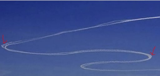
The main one in the middle of the top streak has a double section, as has the left bend. Two planes flying close, with a bit more separation in a few spots?
 
Not the corner, definitely looks like an overlap from a second flight.
View attachment 8517

I have mentioned this region in OP but did not elaborate. This double stranded region is present in all images, even those of the aged contrail, where the strand separation appeared to have increased. It suspect that the KSBY post about "contrails from a pair of jets" was not because the author did see the two planes himself but merely due to the presence of two strands in the title photo.

Large two- and four-engine jets are also known to create double-stranded contrails, which usually merge together when the contrails spread out. However, in the presence of a significant wind shear the strands may remain separate, particular when they are at slightly different altitudes due to banking of the plane at a turn. I think this was the case here with the wind shear progressively increasing the contrail separation. It would be the same effect for a pair of jets flying in tight formation (at approximately the same distance from each other as the engines on the different sides of a large jet), but they would have to stay in formation all the time this contrail was laid.
 
There's a "cloud" across the whole image below the contrail, that looks like another older contrail spreading out. The far left end of it is folded back in a reverse S shape, similar to the middle of the W. So someone did another similar spiral earlier?

From the satellite images, it could be the edge of cloud bank above the ocean, breaking up near the coast.

The main one in the middle of the top streak has a double section, as has the left bend. Two planes flying close, with a bit more separation in a few spots?

See my previous post.
 
Thanks, trailspotter. I am new to this -- I live in a concrete canyon with not much sky visible unless I crane my neck (not a safe position forgetting around). Actually the airport is only a few miles away but they never fly over my place. But I am loving the images here.
 
I have determined probable altitude and initial location of the trail as well as its orientation and movement across the sky with the wind.
View attachment 8508
The contrail was formed at a high altitude of about 39,000 ft over the ocean west of Diablo Canyon Power Plant and carried by a WSW wind toward Vandenberg Air Force Base.

That whole area west of the Diablo Canyon Power plant seems to be reserved military airspace with an unlimited ceiling limit.

http://vfrmap.com/?type=vfrc&lat=35.237&lon=-120.643&zoom=10

3.png
 
Last edited:
That whole area west of the Diablo Canyon Power plant seems to be reserved military airspace with an unlimited ceiling limit.

http://vfrmap.com/?type=vfrc&lat=35.237&lon=-120.643&zoom=10

View attachment 8522
Thanks, this is very informative. I've seen similar maps showing the areas of reserved military airspace off the UK coast and thought that there also could be designated offshore military areas in the States.

EDIT: Modified the TH post accordingly to his changes.
 
Last edited:
This might not sound as intelligent as most of the responses given, but could wind cause this or an updraft. Sometimes updrafts have been known to punch holes in cloud cover. Could this be a contrail from 1 plane that was in a holding pattern or made a turn and then wind blew in the middle part to create the "W" looking contrail.
 
Large two- and four-engine jets are also known to create double-stranded contrails, which usually merge together when the contrails spread out. However, in the presence of a significant wind shear the strands may remain separate, particular when they are at slightly different altitudes due to banking of the plane at a turn. I think this was the case here with the wind shear progressively increasing the contrail separation. It would be the same effect for a pair of jets flying in tight formation (at approximately the same distance from each other as the engines on the different sides of a large jet), but they would have to stay in formation all the time this contrail was laid.

I think that's incredibly unlikely. There's significant separation in the straight sections that seems like it could only have come from two jets in formation.

upload_2014-8-17_8-51-51.png
 
This might not sound as intelligent as most of the responses given, but could wind cause this or an updraft. Sometimes updrafts have been known to punch holes in cloud cover. Could this be a contrail from 1 plane that was in a holding pattern or made a turn and then wind blew in the middle part to create the "W" looking contrail.

Not in this case - people observed the trails being laid. But see:
https://www.metabunk.org/threads/squiggly-sinusoidal-thin-trails-over-europe.3194/
 
But in this image Dee posted above, doesn't it look like 2 different contrails that merged together.
7885-e087126483378f6c262550ee7c1513c6.jpg
 
Last edited:
Compare with trails that are known to be from pairs of fighters.
a57bc1115ad8ba95d3d2621f2fcf62a9.jpg


They appear wider at the sides of the turns, but this is largely due to perspective foreshortening.

Here's a simulated contrail:
20140817-091400-ymhx4.jpg


But view it from more of an angle:

20140817-092244-kukes.jpg


So I think where it "looks like three in the banks" it's really just two, and just seems to be spread out more.
 
Trigger, could you please explain this map a little better.

I'll try, but I'll warn you that I'm neither a pilot, nor a navigator, and any information I give will be found via Google.

Are all the blocks outlined in Blue that clearly state "warning####" reserved for the military. If that's the case it seems like there isn't any room for commercial flights.

Trailspotter figures the contrails originated over the ocean and west of San Luis Obispo. That's sections W-532n/e/s.

According to the legend of the VFR chart:

4.png


Sections W532n/e/s are used intermittently and reserved by NOTAM notices through LA Center.

Perhaps some pilots can better answer your question. I think we have a few lurking about.
 
Sections W532n/e/s are used intermittently and reserved by NOTAM notices through LA Center.

Perhaps some pilots can better answer your question. I think we have a few lurking about.

I think the legend of the Aeronautical Chart explains it sufficiently.

AND yes, NOTAMS are issued, and nowadays can be accessed online too.

(ETA): A lot of info can be gleaned from just reading the legend panels, from that source. Any other questions? Feel free to send me a PM.
 
I think that's incredibly unlikely. There's significant separation in the straight sections that seems like it could only have come from two jets in formation.

View attachment 8530
Well, the straight section is actually twisted and in some later photos looks like a helix (or spiral), not dissimilar to other twisted contrails that look like a double-stranded helix:
https://www.metabunk.org/threads/moscow-spiral-contrail-helix-cloud-theories.1031/

Of course, it could be that the 'twist' was not due to a turbulence, but resulted from the two jets practicing roll while staying in formation.

Since Trigger Hippie identified the area where the contrail was formed being restricted military airspace, its military origin is almost certain. The hypothesis of two jets flying in formation and practicing synchronous turns and rolls can readily explain all observed peculiarities of the contrail, but is this the only possible explanation? I'm not yet convinced.

Does anybody here know this guy, Dave Hovde of KSBY, to ask him where the info about a pair of jets came from?
 
I haven't seen this answered yet, and maybe it wasn't even the reason for this thread, but how does a "W" contrail even happen. Is this typical maneuvering for military jets? I see you estimated the contrail to be about 80 miles long which means a military jet would've traversed that length in about 8 minutes or so at the average cruising speed of 570mph. I'm assuming half the length is in the "turns". Would military jets be flying in formation while make such tight turns and what benefit do they get out of training this way?
 
I haven't seen this answered yet, and maybe it wasn't even the reason for this thread, but how does a "W" contrail even happen. Is this typical maneuvering for military jets? I see you estimated the contrail to be about 80 miles long which means a military jet would've traversed that length in about 8 minutes or so at the average cruising speed of 570mph. I'm assuming half the length is in the "turns". Would military jets be flying in formation while make such tight turns and what benefit do they get out of training this way?

The contrail dimensions come from the fitting contrail models to the photographs. The straight sides are about 20 miles long each, approximately parallel to each other and about 24 miles apart. There are three half-turns between the straight sides with radius of 4 miles, their total length is about 40 miles. That is, the contrail fits into a square with the side dimension of 24 miles, its total length is about 80 miles.

I have no answers to the remaining questions. But I have seen this kind of training in a documentary about "Red Arrows", the elite british aerobatic team. They have recruited new members, who are professional fighter jet pilots. Yet their first training flights were just like that, doing simple manoeuvres while flying in a tight formation with an experienced team member.
 
I haven't seen this answered yet, and maybe it wasn't even the reason for this thread, but how does a "W" contrail even happen. Is this typical maneuvering for military jets? I see you estimated the contrail to be about 80 miles long which means a military jet would've traversed that length in about 8 minutes or so at the average cruising speed of 570mph. I'm assuming half the length is in the "turns". Would military jets be flying in formation while make such tight turns and what benefit do they get out of training this way?
Because it's a big sky and they can. There may be no way of knowing why they did those turns but the most important part is that although the shape is unusual, there is nothing unusual about the maneuver.
But it's easy for someone to say "look, planes don't do that" and use that as proof of their theory de jour.
If I had to guess? Someone needed to be in the air for a specific period of time and only had a certain area to work. So "S turns" for space was what they chose instead of a hold or two circles or whatever.
 
Maybe it was one of the "scissor" maneuvers and because of our position relative to the contrail it's hard to determine the height in any one point of the contrail. I could see this maneuver representing the 'W' shape in that part of the contrail

External Quote:
Flat scissors[edit]
Flat scissors, also called horizontal scissors, usually occur after a low speed overshoot in a horizontal direction. The defender reverses the turn, attempting to force the attacker to fly out in front and to spoil aim. The attacker then reverses, trying to remain behind the defender, and the two aircraft begin a weaving flight pattern.[49]
10cefd8cbbc253a0360777ee1eea43f6.jpg

http://en.wikipedia.org/wiki/Basic_fighter_maneuvers#Pitchback
Except the picture doesn't look like that. Message #33 postulates that it was two aircraft practicing turns while in formation. So far that's the best guess for me. Not the final answer but the best guess.
 
Back
Top