Could The Gimbal Video Show an Atlas V Launch?

Hi Mauro, I see two main problems with this hypothesis :
1) the plane does not turn nearly as much as that, it's turning by an angle of about 60-70°. The average rate of turn is ~2°/s, over 34 sec that makes a ~70° turn. In your model the plane turns by more than 90°.
2) Gimbal is going "towards the wind", they even say the wind is 120 Knots to the west in the video. It means it's going towards the coast as there were westerly winds. The rocket was launched the opposite direction right ?

By the way I never paid attention to it but 120 knots is a hell of a wind speed, ~140 mph. Maybe there was a burst of wind at the time, because the mean wind speed for the day is half that speed (maps above). I wonder if I could find more precise wind data.
 
Hi Mauro, I see two main problems with this hypothesis :
1) the plane does not turn nearly as much as that, it's turning by an angle of about 60-70°. The average rate of turn is ~2°/s, over 34 sec that makes a ~70° turn. In your model the plane turns by more than 90°.
I don't think that can be said. There are no instrumental clues in the video which allow to tell how much the airplane turned, nor any reference points in the video which can be used for the same purpose. And the clouds moving backwards are a sure sign the F-18 is turning at a rate faster than the ATFLIR, so whatever the F-18 turned it must have turned more than ~60°. The more the F-18 turns quickly, the more the clouds move fast backwards. So measuring the speed with which the clouds flow in the video, and knowing from the display the turn rate of the ATFLIR, it may be possible to calculate what the actual turning rate of the F-18 was. I'm not 100% sure about this last claim (about calculating the turning rate from the clouds flow), maybe some other parameter is involved (ie. the distance of the F-18 from the clouds), but in any case the F-18 turning rate must turn out greater the ATFLIR turning rate, else we could not see the clouds moving from left to right. A fast turning rate is also consistent with the 'stern conversion' maneuver, he wants to get asap at the rear of the Gimbal, unaware it's actually hundreds of km away.


2) Gimbal is going "towards the wind", they even say the wind is 120 Knots to the west in the video. It means it's going towards the coast as there were westerly winds. The rocket was launched the opposite direction right ?
Yes, and indeed the F-18 is moving west, towards the coast, in my reconstruction. This both fits the Atlas viewing geometry and is consistent with what you say, even if the F-18 was probably a bit far from the coast, as usual there is a whole space of unconstrained parameters here so the F-18 could have been on a stripe roughly parallel to the Atlas trajectory, something like this possibly:
1637314004926.png

The F-18 cannot be placed too much to the west side, nearer to the coast, or it will look at the rocket the wrong way. If it is too much east the video should be shorter, because the Atlas 'turns off' at the end of the marked trajectory. Too much south and the pitch angle will become too steep. There is more berth on the north, the problem there is not to have the F-18 too far from the Atlas, it must be near enough for the IRs to create glare into the ATFLIR. I cannot certainly say confidently how much this distance can possibly be, but in the order of 200kms look reasonable to me, that's about what's depicted in the drawing.

The eastern and western limits can be calculated using geometry, spherical if you really want the most precision (or by trial-and-error in Blender, ugh). The southern limit requires the knowledge of the flight envelope of an F-18 (how much can it pitch up and then make a turn at, say 3.5°/s rate?). The northern limit needs the knowledge of the 'glareability' of the ATFLIR when imaging the exhaust plume of an Atlas, not exactly an easy task. And knowing the exact flight profile of the Atlas (instead than just two points, as I do) would surely help.

The clouds have two main parameters: how much their top rim is higher than the F-18 and the horizontal distance from the F-18. They can be fitted to a wide variety of angles and aspects to the F-18 position (and height and distance are fractals in the real clouds, even better).

Edit (I forgot): and yes, the Atlas flies eastwards, opposite the F-18 (all launches do, so they can take advantage of the Earth rotational speed).


By the way I never paid attention to it but 120 knots is a hell of a wind speed, ~140 mph. Maybe there was a burst of wind at the time, because the mean wind speed for the day is half that speed (maps above). I wonder if I could find more precise wind data.
Urgh I just self-learned the basics of aeronautics three days ago, I cannot safely say anything about winds and airfoils, but I guess that the more wind there was, and the more eastward it was (against the F-18 velocity vector at the beginning of the encounter), possibly maybe slanted a bit upwards, as in an updraft, the more the F-18 could pitch up before going beyond the limit of its maximum angle of attack. And the more the pilot had to throttle the engines thrust up to compensate the drag. But see the caveat, I might be saying something quite stupid. Anyway, he's a damn good fighter pilot.
 
Last edited:
What seems to me (but I may be wrong, see previous caveat) is you have the impression that if you increase your elevation, keeping your line of sight pointed steadily 2 degrees below (earth-side) the horizon, you will see a slice of sky very far away, while this does not happen on a flat Earth model. But this is not true: you are always looking 2 degrees below the horizon, wherever it is, and you see only Earth (indeed, you see more Earth surface than on the flat model, due to the curvature).
Keep your line of sight 2⁰ below eye level/horizontal, and as you gain altitude, the horizon will cross your line of sight as you cross ~15000 feet.

In the simulator drawing (feel free to go to site and change parameters), the eye level is the same for both views (indicated by a purple line); the Flat Earth horizon is at eye level, while the globe horizon is lower.
I'm not going to answer anymore to this kind of objection, it's annoying, really (at the limit of harassment). Go look at the drawings of the reconstructed encounter above (post #199), then add -2° wherever you feel pleased to add them, then go in peace.

Add also a curved Earth below the F-18 in the vertical projection drawing, ~8km below, given you are at it (Hint: use the same vertical scale as the one used to depict the height of the Atlas, assume its 40km or 20km or 80km or whatever if you really need a number. Another hint: for he curvature of the Earth you now need the horizonatl scale, use the same one as the one used to depict the Atlas, say ~200km from the F-18 to the Atlas (that should be along the line of sight, feel free to estimate it projected horizontally if you wish)).
 
Last edited:
Note also that an "artificial horizon" indicates horizontal (eye level), not the actual horizon. I don't think there's any aircraft instrument that does.
How can you keep the ATFLIR line of sight pointing steadily -2° below the horizon, with the precision of no more than 1° (and probably less, who said military hardware is expensive for a reason?), while you're chasing an IR light in the sky in an F-18 at Mach 0.58, rolling and pitching around?
The F-18 wasn't "pitching around", and the ATFLIR compensated for the bank. (It would also compensate for pitching. It swivels. It was made for this.)
You are arguing from your flawed understanding of what the indicated angles mean.
Sure, sorry I did not think about it sooner myself. It's horrible I know, but I hope it gives the idea. The only thing missing is the Earth surface, it's 8300m below the F-18, using as scale the height of the Atlas it would be a straight horizontal line.

1637164485355.png
With this setup, the clouds ought to appear to move right-to-left, but they don't.

Source: https://m.youtube.com/watch?v=QKHg-vnTFsM

I find the movement of the clouds as seen in the video consistent with my model: they move as expected for an airplane skirting a (sub-vertical) wall of clouds on its left and pointing a camera left, slightly above the upper rim of the wall of clouds, as the model predicts.
I disagree with that. If you're moving past something on your left, the apparent motion of that something is left-to-right.
You are assuming the target is far away, so the camera keeps looking in the same compass direction.
There are no instrumental clues in the video which allow to tell how much the airplane turned,
The bank angle defines the turn rate for a coordinated turn.

Yes, and indeed the F-18 is moving
But it's the UAP that should be moving west, from the spoken words on the video.
 
Note also that an "artificial horizon" indicates horizontal (eye level), not the actual horizon. I don't think there's any aircraft instrument that does.

The F-18 wasn't "pitching around", and the ATFLIR compensated for the bank. (It would also compensate for pitching. It swivels. It was made for this.)
You are arguing from your flawed understanding of what the indicated angles mean.

With this setup, the clouds ought to appear to move right-to-left, but they don't.

Source: https://m.youtube.com/watch?v=QKHg-vnTFsM

Unluckily you used an outdated (and flawed, as @jplaza and @TheCholla helped me to find out) model. You should only use posts 199-200 now. But you are right: in that model the clouds move the wrong way (and the F-18 is nowhere near Jacksonville). In the revised model the clouds move the right way, as explainjed at length in post #200.


I disagree with that. If you're moving past something on your left, the apparent motion of that something is left-to-right.
You are assuming the target is far away, so the camera keeps looking in the same compass direction.
Try walking along a wall on your left, with your head oriented to the left, then you'll tell me what the apparent motion of the wall looks like. You can even simulate the 'reversal' effect if you do it carefully: stop moving (you're not an F-18) and quckly spin left on the spot. In the meantime straighten your head, orient it to the front, but slower than your spinning. Then you'll tell me. I discovered the whole trick this way. If you also look up while doing this it's even easier (not to do, to see the effect I mean).

The bank angle defines the turn rate for a coordinated turn.
Surely you must bank left to turn left, and the more you bank the more you turn, that's it. Then you also have a lot of additional aerodynamical surfaces to modulate how much you actually turn, but I'd be threading on thin ice should I start talking about this, I'm not that knowledgeable, that's all.

But it's the UAP that should be moving west, from the spoken words on the video.

The UAP in the video moves who knows where. The Atlas seen by the F-18 in my reconstruction moves in the same way (I wish I had a video to show, it's certainly possible to make one). And the clouds too. And all the instrumental data we can get from the video are there. But I thank you for pointing out the voices matter, I don't know what to answer here on the spot, I can't even understand a word of what they're saying. I'll go check.


PS.: going to eat now, I hope to find many interesting and motivated critiques (as, I have to say, this one by Mendel I'm answering to, sorry for doing this hastily). Laters.
 
Last edited:
Mauro you are a war machine!
That apparent shifting of the clouds may indicate two things. Either that the clouds are well beyond the object or in front of it but the object is moving much faster than the observer but in the opposite direction.
Unfortunately, I have the feeling that ATFLIR cannot provide reliable data if the object is at a considerable distance. It can be seen from the azimuth trend during the movie. In some cases the LOS converge, in other instances they diverge. As if the object is moving erratically. Returning to the question of the wind, as we have seen its intensity on that day in the area, where the maneuver was probably taking place, was less than half of that stated by the WSO. So that wind probably referred to the object's position as it appeared on radar. Now, extending the analysis over the entire area of the east coast, at all flight levels, that wind was present only in the area above Cape Canaveral and generally central Florida. At this point, to resolve any doubts we need to analyze the narrative. It is necessary that one of the witnesses, whose name we also know, and also has a facebook profile, provided us with crucial information such as the time of observations and above all where he was and in which direction he was looking.
 
@Mauro : we have the bank angle of the plane, its speed, so we can estimate how much it turned. Look at all the geometrical reconstructions that have been made (in the other threads about Gimbal). I think that's a very certain thing that the plane didn't turn more than 90°.

I was able to get more precise wind data for these 2 days, January 20 and 21, 2015. This is from the MERRA2 reanalysis, a 100 km resolution product at 3-hourly time frequency. Using this we can map the wind vectors and wind speed every 3 hours, on January 20 and January 21. I want to see at what time strong winds were present off Jacksonville, which would help refine the time of the event because the pilots mention a strong 120-knots wind.

This is at 400 mb, it should be close to the 25000 ft altitude. Unit for wind speed (colors) is knots. The vectors give the direction.

January 20
Jan20-1.png
January 21
Jan21-1.png
First, the winds are always westerly, which confirms what the pilots say. There is never such high winds as 120 knots, but remember we are looking at a 100-km resolution data here, and those are 3-hour averages. There may be wind gusts that put the wind much higher than what's depicted here. However I would assume the mean wind has to be strong, off Jacksonville where Gimbal was shot, to allow for such high wind. This makes January 21 a more plausible candidate. This day had stronger winds in this area, of at least 60 knots, even 80 knots after 9am (UTC).

We have several pieces to the puzzle that can help us reconstruct the scene (please correct me if I'm wrong, or miss some important information):
- this is happenning off shore Florida, more probably off shore Jacksonville
- Gimbal is going towards strong westerly winds, over a cloudy sky
- 17 minutes before, GoFast was shot, over a clear sky
- given the cloudiness these two days, the plane had to go from a clear sky to a cloudy sky.

Now, January 20 (UTC) has relatively low winds, and mostly cloudy sky off Jacksonville (see the cloudiness here in the infrared : https://climatereanalyzer.org/wx/satellite/)

On the other hand, January 21 (UTC) has stronger westerly winds in the area, and a transition from clear to cloudy sky off the coast of Florida. The clouds are moving eastward quickly during the day, so if the plane is not too far from the coast, morning or early afternoon (still UTC) would be a better candidate. And the fact that GoFast is seen over a clear sky, then Gimbal is seen over clouds, suggests the plane is going offshore, towards the open ocean.

That would match the time of the rocket launch, but at the moment I think there are fatal flaws to this theory (regardless, kudos to Mauro for all his efforts).

Based on all this, in my head I see the F-18 going towards the ocean (with tailwind) sometimes in the morning/early afternoon January 21 UTC, shooting GoFast over the clear sky, then Gimbal after entering the clouded area.

We could go further in refining the event if we knew which direction the F-18 is heading during Gimbal. If we assume it didn't change its heading in the 17 min between GoFast and Gimbal, it would still go offshore (towards the east), which would explain the pilot's comment that Gimbal is going towards the wind (or the west). If they were both going against the wind, would the pilot say that ? This is very much speculation here. But if the F-18 is still going offshore, it reduces the range of possible trajectories in the geometrical reconstructions.
 
Last edited:
Has it been ever mentioned how far from the coast GoFast and Gimbal were shot ? I remember reading about this, but I'm not sure (so much information spread in different threads at this point).
 
I don't think that can be said. There are no instrumental clues in the video which allow to tell how much the airplane turned, nor any reference points in the video which can be used for the same purpose.

Yes we have the bank angles of the plane, and its speed. It gives you its rate of turn.

And the clouds moving backwards are a sure sign the F-18 is turning at a rate faster than the ATFLIR, so whatever the F-18 turned it must have turned more than ~60°.
Pardon me but not sure I follow this argument. I think what you're saying would be true if the F-18 was stationary, only rotating on itself. Here there is the motion of the F-18 (inducing parallax), plus the motion of Gimbal itself. That complicate things a lot. That's why we have to make schematics using line of sights to have an idea of what's going on, or it gets really confusing.
 
That would match the time of the rocket launch, but at the moment I think there are fatal flaws to this theory (regardless, kudos to Mauro for all his efforts).
It wouldn't match. The launch was at 01:04 am UTC, and the plots suggest the high winds were after 09:00 am UTC, thats 8 hours later.
 
Last edited:
Yes that's true, I didn't want to be definitive about that because you may still have wind gusts with a lower 3-hour average wind. But indeed the wind data favors a later time between 9am and 15pm UTC (after that the high winds start being way far the coast).

@jplaza and if like you argue the video was shot at daylight, then we can refine the time even more
 
Last edited:
With regard to the cubes within spheres mentioned in Graves' tweet, I believe that the 45th Weather Squadron based at Patrick Space Force Base in Florida (link) is responsible for assessing the weather for rocket launches, and they release weather balloons at 20 minute intervals in the 4 hour countdown period prior to launches (link). Some of these have the "cube in a sphere" profile when viewed from some angles (link - I'm pretty sure that this has been linked on metabunk before):

balloon.png

Edit: since @Mauro says below (perhaps correctly) that this is off-topic, I merely wanted to note it because it suggests that an aspect of the Atlas V launch (and of other rocket launches, of which there have been an increasing number in recent years), may explain another aspect of the whole East Coast flap, namely the objects visually ID'd as cubes in spheres. I'm also not suggesting that the 5 objects in the wedge formation are balloons, SRBs seem like a more likely explanation (assuming the Atlas hypothesis). Carry on with the detailed video analysis! :)
 
Last edited:
@Mauro : we have the bank angle of the plane, its speed, so we can estimate how much it turned.
I answer to your post because it inlcudes about all the arguments made so far (correct me if I'm mistaken). I try to write in the most 'official' and 'formal' why I can, but this is only for the sake of precision and clarity, not because I want appear knowledgeable or anything like that.

OFFICIAL DISCLAIMER: until one week ago, I did not even know what aeronautics was. Yes I've always being fond of planes and military hardware (I'm engineer after all) but I did not know really anything about velocity vectors and the like, I had some ideas but nothing comparable to what an engineer needs to do any useful work. And yes, I am very aware of the Dunning-Kruger effect, I know I can at any time say the most silly and stupid thing which any person with a minimum of real knowledge will laugh at. That's why my posts are replete with boring caveats, 'but I may be mistaken', 'I may think' and so on. They are not meant as excuses, they are meant to signal my ignorance and call in help from someone more expert than me.

Now onto the real topic. I agree with you, bank angle and turn rate are proportional (I don't know how exactly they are proportional but that's not the matter). Then, in my understanding, the pilot has many aerodynamical control surfaces at his disposal with which he can modulate the effective turn rate. So I'm sure the turn rate can be estimated, I'm sure I don't know how, but most importantly I think the exact rate of turn is just a parameter which, provided it respects some basic conditons (it must be to the left, and greater than the 60° degrees the ATFLIR rotated) can be set to any value one wishes. This will change the exact point where the F-18 is looking at on the Atlas trajectory at a given time, but is by no means an obstacle to my model. See also the answer just below which elaborates on the details.


Look at all the geometrical reconstructions that have been made (in the other threads about Gimbal). I think that's a very certain thing that the plane didn't turn more than 90°.

OFFICIAL DISCLAIMER: I know, I could have done my homeworks better and search much more accurately the available literature. I know, there are surely people who have done outstanding works which I should have referenced. But I'm not writing an academic dissertation or an article for arXiv or a peer-reviewd journal from which my future career depends, I'm just having some fun seeing if my brain can figure out how this strange encounter works. So I apologize to all who have spent efforts to investigate the Gimbal if I did not happen to see their work and I not referenced it. You may see that I tried to reference in my posts every single contribution I got, merit deserves recognition, I'm sorry I could not extend this to everybody who ever studied the Gimbal, really.

Now to the topic!

  • I cannot say for sure how much the aircraft turned, what I can say is that it turned faster than the ATFLIR, else the clouds visual flow in the video would be inexplicable.
  • So it must have been more than 60° for sure, but I cannot say how much more.
  • But I can say that the more the turn ratio of the F-18 is fast the more the apparent 'backwards' speed of the clouds is high. So the video indeed encodes informations about the turning rate: the apparent speed of the clouds is proportional to the difference between the turn rate of the aircraft and the turn rate of the ATFLIR. This looks to me a much more safe extrapolation to do than relying on the bank angle, because many other factors influence the turn rate apart the bank angle, ie. the local wind, or how the control surfaces of the plane were set. The speed of the clouds flow instead does not lie, it's 'simple' geometry [see also the disclaimer in 1st paragraph of post #202].
  • If you want me to shoot a number, I'd say the F-18 turned roughly double fast than the ATFLIR, this by looking at the clouds in the video and letting my basic image-processing brain circuits work. But it could be anywhere, from 60.1° up (including 90°). This just changes the speed of the cloud, measure that and you're set. Having the true turn rate we could then use to it extrapolate something about local winds and/or aedrodynamical control surfaces, but that would be an overkill I guess.


I was able to get more precise wind data for these 2 days, January 20 and 21, 2015. This is from the MERRA2 reanalysis, a 100 km resolution product at 3-hourly time frequency. Using this we can map the wind vectors and wind speed every 3 hours, on January 20 and January 21. I want to see at what time strong winds were present off Jacksonville, which would help refine the time of the event because the pilots mention a strong 120-knots wind.
[images removed]
First, the winds are always westerly, which confirms what the pilots say. There is never such high winds as 120 knots, but remember we are looking at a 100-km resolution data here, and those are 3-hour averages. There may be wind gusts that put the wind much higher than what's depicted here. However I would assume the mean wind has to be strong, off Jacksonville where Gimbal was shot, to allow for such high wind. This makes January 21 a more plausible candidate. This day had stronger winds in this area, of at least 60 knots, even 80 knots after 9am (UTC).
I thank you a lot for what you're doing. Unfortunately I'm not the one who can say anything about how winds interact with airplanes, I'd become the poster-boy for Dunning-Kruger I bet. But you (and other people here of course) could use your knowledge about winds and airplane to deduce things I cannot. That would be really cool.


We have several pieces to the puzzle that can help us reconstruct the scene (please correct me if I'm wrong, or miss some important information):
- this is happenning off shore Florida, more probably off shore Jacksonville
The localization near Jacksonville killed my first model, you can be sure it happened somewhere there.

- Gimbal is going towards strong westerly winds, over a cloudy sky
About the winds: well you may say that if you wish but the Atlas is a rocket.. winds are not a great concern for him (at first approximation at least) when he's some tens km up. The sky may have been cloudy or totally clear, the only thing I need is one cloud which could be as small as a few kilometer in diameter or as large as a tropical storm (I cannot know) whose top is higher than the F-18 altitude. Under the F-18 there may be anything, from more clouds to clear sky, just the clouds need to be lower than the F-18. The F-18 is skirting the sub-vertical wall of the cloud when the encounter starts.


- 17 minutes before, GoFast was shot, over a clear sky
GoFast does not concern me at all. My first idea is that it was shot later, when the pilot of the F-18 landed on the Roosvelt and told everybody of the amazing thing he had just seen evading his F-18 like a.. uh... rocket. Then somebody else jumped the wagon and saw a ballon or whatever and we get GoFast, a mini-UFO flap with just one repetition. Only my personal incidental opinion, this is not the GoFast thread.


- given the cloudiness these two days, the plane had to go from a clear sky to a cloudy sky.
Not necessarily, see above. It could have been in clear sky or have a compact deck of clouds 200m or whatever below. Then we need a towering cloud on the left, from small to enormous it does not matter. See above.

Now, January 20 (UTC) has relatively low winds, and mostly cloudy sky off Jacksonville (see the cloudiness here in the infrared : https://climatereanalyzer.org/wx/satellite/)

On the other hand, January 21 (UTC) has stronger westerly winds in the area, and a transition from clear to cloudy sky off the coast of Florida. The clouds are moving eastward quickly during the day, so if the plane is not too far from the coast, morning or early afternoon (still UTC) would be a better candidate. And the fact that GoFast is seen over a clear sky, then Gimbal is seen over clouds, suggests the plane is going offshore, towards the open ocean.
I'm not a meterologist, sorry. Is there at least one high cloud reasonably near where I put the F-18 in my map? Then the F-18 was there, skirting the northern border, near the north-western 'corner' of the cloud.

GoFast does not concern me at all as already said.

That would match the time of the rocket launch, but at the moment I think there are fatal flaws to this theory (regardless, kudos to Mauro for all his efforts).
Thanks for the kudos! I wrote all this so my theory can be reviewed, if there are any more fatal flaws they will be spotted. If this happen will not give me any problems at all, I assure you. If it doesn't happen I'll be happy of course, but nothing will really change for me.


Based on all this, in my head I see the F-18 going towards the ocean (with tailwind) sometimes in the morning/early afternoon January 21 UTC,
Make some drawing similar to those I did (or use any other way you wish to use) and see if you can find a reasonable solution which respects all the constraints (your candidate Gimbal object flight path, ATFLIR declination, movements of the clouds in the video, basic physics, pilot's conversations, cloud cover that day, all what you can get).


shooting GoFast over the clear sky, then Gimbal after entering the clouded area.

We could go further in refining the event if we knew which direction the F-18 is heading during Gimbal. If we assume it didn't change its heading in the 17 min between GoFast and Gimbal, it would still go offshore (towards the east), which would explain the pilot's comment that Gimbal is going towards the wind (or the west). If they were both going against the wind, would the pilot say that ? This is very much speculation here. But if the F-18 is still going offshore, it reduces the range of possible trajectories in the geometrical reconstructions.
GoFast is not Gimbal, see above. If you can show the F-18 was going offshore (which it may have done even in my model, I did not explore all the parameters space [I said that I think 50 times in this thread lol], but I very much doubt it) that will be very nice. But who knows, try and then post.
 
Last edited:
With regard to the cubes within spheres, I believe that the 45th Weather Squadron based at Patrick Space Force Base in Florida (link) is responsible for assessing the weather for rocket launches, and they release weather balloons at 20 minute intervals in the 4 hour countdown period prior to launches (link). Some of these have the "cube in a sphere" profile when viewed from some angles (link - I'm pretty sure that this has been linked on metabunk before):

View attachment 47913
Hi @GlobularOrb, I'm sorry but cubes-within-spheres should go into another thread.
 
Mauro, you keep writing stuff like:
I wrote all this so my theory can be reviewed, if there are any more fatal flaws they will be spotted. If this happen will not give me any problems at all, I assure you.

But that's not how you behave.
Each time you are confronted with something that falsifies your theory (wrong date, wrong distance...), you basically choose to ignore it.

And now you even start to invent stuff on your own:
The F-18 is flying west, with a bank of clouds on his left, the upper rim of the clouds is higher than the F-18. The pilot sees on his left, up above the rim of the clouds, a fast-moving light.
No he did not. He saw a radar return when arriving back from a mission.

The F-18 has almost completed the stern conversion maneuver (nothing more than a sharp arc of a circle in this case): the pilot expects to find the target about in front (and a bit higher) of him, but it has suddenly vanished.
Not it hasn't. The object reverses direction.
On top of that, you assume the pilot can make a stern conversion maneuver without any data on distance, heading, and speed of the approaching target. But he needs this data to determine when and where to start his turn, and at what turn rate, to get behind the target. (It wouldn't even surprise me if an F18 can do this maneuver automatically based on its sensor data).

Do you realize this is a textbook example of confirmation bias?
I can imagine the attractiveness of the ATLAS theory for a debunker. And I know Italians are passionate people. But sometimes there simply is no click..
 
Yes that's true, I didn't want to be definitive about that because you may still have wind gusts with a lower 3-hour average wind. But indeed the wind data favors a later time between 9am and 15pm UTC (after that the high winds start being way far the coast).

@jplaza and if like you argue the video was shot at daylight, then we can refine the time even more
Sunrise was about 12:30am UTC (7:30 ET). Then the time window available is between 12:30 and 15:00 UTC.

Also, from the satellite, the first image in visible is a t 14:30 UTC, showing some clouds near the coast:
20150121_1430UTC_VIS.png
Same time, in IR:
20150121_1430UTC_IR.png
There is little contrast with the sea. I guess that means they were low clouds (How low? No idea!).

So, I think the time frame 12:30 - 15:00 UTC (7:30-10:00 am ET) is reasonable, as it also correlates with the reanalysis graphs you brought.

Edit
--------
BTW, I found data from a atmospheric sounding at 12:00 UTC at Jacksonville. It's only a local measurement, but is coincident with your graphs

Pres (hPa) : 400.0
Altitude (m): 7360
Temp (ºC): -27.1
...
DRCT(deg): 290
SKNT (knot): 83

Content from External Source
DRCT: Wind direction in degrees
SKNT: Wind speed in knots
-----------

That said, that low cloud near the coast seems to be persistent during the whole day, so maybe it was also there before sunrise. I still doubt it was possible to see it with ATFLIR, though.
 
Last edited:
Mauro, you keep writing stuff like:


But that's not how you behave.
Each time you are confronted with something that falsifies your theory (wrong date, wrong distance...), you basically choose to ignore it.
One example maybe? May I suggest the 'it was near Jacksonville' claim, which I said I would look into, and then I agreed you all were reason and that it had to be near Jacksonville and my model was wrong so I re-did it? Or the direction of clouds rotation, which I explicity said (after some time of pondering and wrong turns taken) I had got it wrong, while now it's right in my model, and I even explained in detail how it happened?

The objections I think have no merit I say they have no merit (and I explain why I think that, then I may be wrong and hopefully change my mind), if I think they do have merit I said they do, no matter what that means for my theory.

So the next time you want to accuse someone of bad behaviour (or hypocrisy, your sentence can be read both ways) at least check your sources and verify it stands.


And now you even start to invent stuff on your own:
You are right, I added a bit of dramatization. Proud of it, actually. What can I say, tell me I'm an idiot if you wish, yesterday night I almost felt as I was there in the F-18 (no G-forces luckily) looking up, seeing a light, then.. but I digress.

No he did not. He saw a radar return when arriving back from a mission.
He may have seen or being informed via datalink of any possible radar return of this world, who cares, the world abounds with radar returns. This can at most demonstrate that he was on alert during the flight. Then he saw the light, in a few seconds he had already decided how to turn left to get to the tail of the target, how to pitch up to get the damn thing in the ATFLIR, how to give gas to counteract all this and.. I'm really amazed by his skills. But I already said that. He only misjudged the distance by a factor of, uh, let's say twenty. But no human being, not even the best pilot, can reliably judge the distance of a light in the sky, so this is no problem for the theory too.


Not it hasn't. The object reverses direction.
I cannot know how exactly the object disappeared, because the video ends before that. I suggested three possible ways it could happen, there may be more I didn't think of, this does not matter to my model.

That said, I leave to someone else the frame-by-frame analysis of the video. As I already said, I think at least the turning rate of the F-18 could be probably retrieved (from the clouds visual flow!), a nice endeavour if anyone is in the mood. If any other wiggling and bumping or reversals or jolts can give more informations, they're welcome. The object reversing or not is only a question of geometry, F-18 turning rate, ATFLIR turning rate and such. I'm already content of having understood the reversed movement of the clouds (and some other things too, btw). When you have a demonstration that your reversal is significant for my model (which may ever well be!) let me know and I'll check your data. Just as I did for Jacksonville. Just as i did for the visual flow.

On top of that, you assume the pilot can make a stern conversion maneuver without any data on distance, heading, and speed of the approaching target. But he needs this data to determine when and where to start his turn, and at what turn rate, to get behind the target. (It wouldn't even surprise me if an F18 can do this maneuver automatically based on its sensor data).
I told you, he was damn good. I wouldn't want to dogfight him not even in a simulator, me on an F-22 and he on an F-86, really, I almost hear his bullets piercing my precious radar-absorbing skin...

Do you realize this is a textbook example of confirmation bias?
What exactly is a textbook example of confirmation bias? That's not clear at all from your post. And then, claims without evidence can be dismissed without evidence, and so do I with your.

I can imagine the attractiveness of the ATLAS theory for a debunker.
And I can imagine its un-attractiveness for a believer. Now what?


And I know Italians are passionate people.
Has my nationality anything to do with the Gimbal video? I'm also quite atypical as an Italian, but that's yet another matter.
 
Last edited:
Yes we have the bank angles of the plane, and its speed. It gives you its rate of turn.
Sorry I forgot to answer you before. You are right of course, what I wanted to say with 'instrumental data' was 'data which can be directly derived by the readings' (which includes the roll angle, even if there's not a specific number reporting it). The turn rate is ihmo excluded because it depends on more variables than roll angle and speed (which can both be read by the display), evenh if roll angle and speed are surely the main factors. But this has already been discussed at length before, imho the clouds visual flow is a better and more direct way to measure the turn rate, but all this does not influence my reconstruction.

Pardon me but not sure I follow this argument. I think what you're saying would be true if the F-18 was stationary, only rotating on itself. Here there is the motion of the F-18 (inducing parallax),
(and don't forget the ATFLIR, that moves too)

plus the motion of Gimbal itself. That complicate things a lot. That's why we have to make schematics using line of sights to have an idea of what's going on, or it gets really confusing.
I agree with you, we're used to live in a (practically) 2D world, 3D world is very confusing. On the specific point: I really don't think I can conceive a better explanation than the one I did in post #200. You're surely reason: the F-18 was also going forward of course, I tried to show that in my drawing (the 'F-18' moves a bit forward every time) but there are limits to what I can do (and I'm already pretty happy about the idea of using numbers to pin the direction of the flow, isn't it cool?). I included lines of sight of course or the drawing would have been impossible to understand.

So it's indeed more complicated than what I wrote, as you rightly say the forward speed should be taken into account but this will matter little. I cannot give you a numerical demonstration (too much math I fear, I may succeed, it's not so fundamentally difficult after all, but....), but notice that linear motion has no hopes of 'overriding' the effects of a rotation: just by rotating say 60° the line of sight changes dramatically, you need a lot of linear motion before achievieng comparable changes. You can even achieve (apparent) superluminal motion by just swinging a light source back and forth onto, say, the Moon: change the angle fast enough and the light spot on the Moon will move at superluminal speed (not that this matters to Gimbal, it's only as an additional example). But you are right, I should have added a note on linear motion (as an excuse, it was past 04:00, but I should have added the note nonetheless).

PS.: the residual linear motion will also complicate the retrieval of the turn rate from the visual flow, of course, not-as-easy as I thought before, but I bet it really matters little. Just a bet!
 
Last edited:
Sorry to bother but I have two notes (and then a question) to make.

IMPORTANT NOTE (in general, and to post #199 specifically)

At the moment I'm not actually claiming anything (but yes, I readily admit I have sometimes been guilty of overconfidence, need to get better at that for sure). I need the Blender model and concrete numbers in hand before I can claim anything. The drawings in post #199, where I reconstructed the encounter, look nice (and maybe even convicing) in 2D, but in 3D it's another matter. I said they were 'qualitative', but I had better have stressed that they are only the basic idea, indeed they are even misleading if taken at face value, 3D cannot just be flattened and all thing remain equal. Ie.: if you look at the drawings the lines of sight point to a trajectory which is some minutes (in time) long, not 34 secs as in the video. They are nice, they show the basic idea correctly I think, but don't take them at face value.

NOTE (to post #200)

Note suggested by a remark of @TheCholla. I tried to show in my drawings that the F-18 moves forward as it rotates (it's describing an arc of a circle), see this version where I highlighted this adding a green line to show the forward motion:
1637365664203.png
I had better add a note to say this forward motion should be included in the calculations, then I forgot this because it shouldn't change much (the drawing is very crude, but notice how the forward motion is ~5 numbers and the rotation at the end has 'rewound back' the numbers by 2 nonetheless (I'm comparing the first and last row, the first one 'looks' at a '7', the last one 'looks' to a '5'). I guess this will be even less significant for a real F-18, but as always I may be wrong. In any case I then forgot it for good (overconfidence, you know). Anyways, all of this does not change anything for my explanation of the backwards visual flow of the clouds, it just makes it more difficult to make calculations about the F-18 turn rate (with which I live happily without btw, I just need the turn of the F-18 to be greater than the rotation of the ATFLIR).


QUESTION

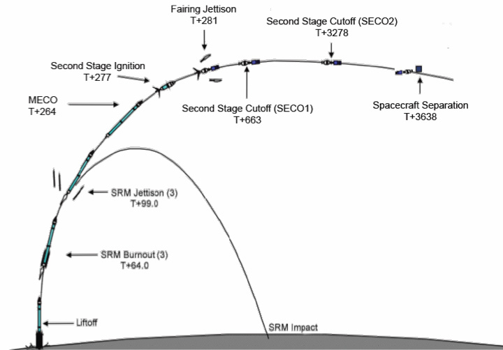
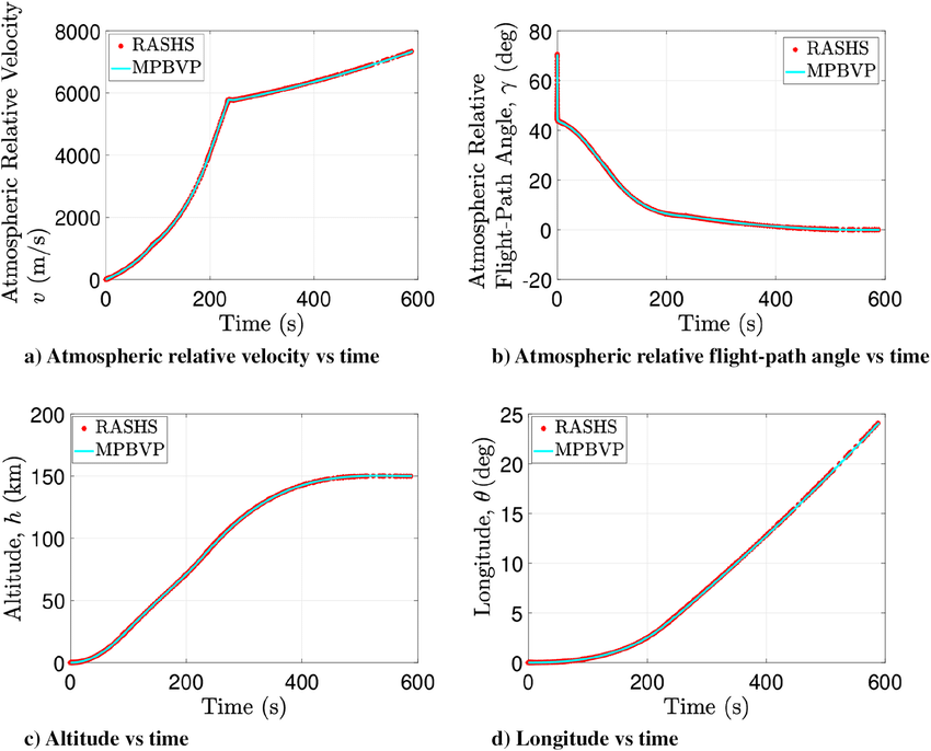
I know, it's a tough one, but I would very much like to start with some solid baseline with the Blender model. A very big source of uncertainty (thus parameters, thus choices, thus 'tinkering', then Blender behaves, then I utter very bad words...) is the trajectory of the Atlas: I don't mean the trajectory on the horizontal plane, that's well known, but I mean the vertical profile. I only have two points determined with certainty, not much over a length of 280km (and they're both above 70km on top of that).

The trajectory profile should be possible to get, it's surely not classified, it was even live feeded and some of the crucial data are visible on the slides which were found (only two usable unfortunately, the two points in space+time I was referring to previously). Yah I know, maybe a FOIA request could help, but I'm sincerely not willing to embark myself in such a feat, and from Italy (nor I want to spend any real $ on this Gimbal thing, lol). I surely won't ask you to file a FOIA for me of course (I also hate waiting for months), but if anyone knows a guy who once lived in Cape Canaveral who knows a guy who once worked for someone who maybe could ask someone-else-in-the-known... that vertical profile of the Atlas launch could come to light from some dusty drawer. Or anything like that (*) (**)

Good night everyone.


(*) PS. I have already found many profiles of Atlas launches, the problem is every launch is different. I need precisely that launch, or at least a launch who put into orbit a satellite with similar mass and orbital characteristics I guess. I'm no rockets guy.

(**) PPS!!!!! Of course I'm only talking about absolutely lawful means! I don't really need to write that here on MB I think, but better safe than sorry. Good night again.
 
Last edited:
Do you mean this? (timestamped at 46:20)

Yes exactly! The two points I could determine come exactly from that kind of slides (see post #106 for the data sources I have on Atlas 551). But the probem of that video is the 'animated slides' start to show the numbers from the 46:20 time mark onwards when the rocket is already ~160km high and too far from Cape Canaveral anyway (I guess at Tlaunch + 8 minutes or something like that). I would need the very same animated slides, with numbers (and a way to timestamp them, because they don't show the time), but spanning say from T = ~Tlaunch + 0 to let's say Tlaunch+6 minutes, those I could not find (there are similar slides shown near the beginning of that video, unfortunatley they do not have the numbers, nor did any other videoclips I could check, in the timeframe of interest).

Or, something like this would even be better (saving a lot of work), I only need the Altitude vs. time graph (the other ones would be cool to know too, of course) [edit: actually, I need the Longitude vs. time too, which is (with some assumptions and complications due to the Earth not being flat, that matters in this case) about the same as Horizontal distance travelled vs. time, or even better just the latter one (with a measure in miles or km on the y_axis, not in degrees of longitude)]:


[this was Atlas V 411, not linking the source because it does not matter anyway]


Or even, someone telling me ie. 'you can just approximate that with a parabola (or any other curve, it looks a strange curve to me actually from the Atlas V 411 data, but who knows) with the 'vertex' on Cape Canaveral and passing through the two points you know', that would be good too.
 
Last edited:
Here is a model that shows the vertical profile of the situation here :

- the earth surface is the blue line (circle equals to Earth radius at 30N, Jacksonville latitude
- the clouds are shown as the dashed grey line, their height (in m) can be adjusted (on this example, this is ~5000m)
- the dotted line is the horizon (horizontal, I've seen it's very debated what the 2° angle means, but that what I understood it was)
- the fighter is the F18 point
- Gimbal is the red point, it's position along the vertical line of sight can be adjusted, and the distance to the fighter is given (in nautical miles)
Vertical Profile.jpg

There is nothing very uncertain here, and because we don't know the cloud height I leave it as a free variable, as I leave the distance to Gimbal variable too.

You'll see that a distance to Gimbal of 200 miles and more, that would be needed for the rocket theory, is impossible. Whatever the cloud height is, it's either out of the field of view (if the clouds are low), or in front of Gimbal (if the clouds are high).

Of course this is if the 2° angle is relative to the horizontal. I got that @Mauro doesn't agree with that, but I cannot say much about that as I'm not an ATFLIR expert.

You can play with that schematic here if you like : https://www.geogebra.org/geometry/cxbxxmrc
 
I have made little progress with actual numbers and models for now, but at least I have put the whole problem of finding the possible geometry of the encounter on more firm bases. So I think I can at least present you with a ‘math problem’ which states the geometric problem, surely not written as a professional mathematician would, but all the pieces should be there and, hopefully, clearly explained. Unfortunately, it’s long.

Notice! This post regards only the problem of finding where the F-18 was (and some other things) and how he sighted the Atlas, it has nothing to do at all with the clouds in the video, even if I used the observed clouds flow to constrain a parameter of the problem.


ABSOLUTE FRAME OF REFERENCE

The coordinate system is the usual 3-D representation (used also by Blender):​
1637423386251.png


The position of the origin is arbitrary, but setting it to the position of the Cape Canaveral launch site looks to me the best way to simplify the calculations (I may be wrong).

The spatial orientation of the frame of reference (the direction the axis point to) is arbitrary, but of course it makes things easier if Z is the local vertical, the Y-axis runs from South to North and the X-axis runs from East to West.

Notice this introduces a simplification, therefore errors in the numerical results: the assumption the Earth is flat. It’s not the case to revive a diatribe here, my opinion is this assumption just introduces some error in the final numbers, and small errors at that. This looks pretty obvious to me, but in case I will prepare a more detailed explanation. Finicky note: setting the origin of the XYZ reference frame near the midpoint between the (hypothetical) position of the F-18 and the Atlas would reduce this error (and add unnecessary complications).


F-18 COORDINATE SYSTEM

Roll, pitch, yaw:
1637423476501.png


They are always referenced to the absolute XYZ frame if not explicity said otherwise, indeed I may be better use ‘bearing’ instead of ‘yaw’ for clarity, I don't know, any advice on this matter is gladly welcomed.​


ATFLIR COORDINATE SYSTEM

[You can skip to the following paragraph, it looks I was too much worried about a possible additional complication]
The ATFLIR sits under the left wing, I guess a couple meters or such from the airplane midplane:
1637423526909.png


This introduces a very unfortunate complication: calculating where the ATFLIR points to when the airplane roll pitch and yaw angles change becomes complicated because we must also take in account the offsets along the XYZ (relative to the plane this time! This is the single time I use xyz in that sense) axes between the ATFLIR and the origin of the coordinate system of the plane. More simply: we need to take in account the ATFLIR is (say) two meters left, three down and five forward of the centre of the plane.

This is not that difficult to do using matrices to calculate rotations (provided one knows how to do that, and has the tools to do it), but it’s just impossible in Blender where we should represent at the right scale both objects in the meter size range (the exact ATFLIR position) and objects in the hundreds of kilometrs range (the lines of sight).

When I did my first (and, I remind everybody, flawed) Blender model I just put the ATFLIR at the airplane center point. But this is dangerous, a difference of one meter in the pivot point of a rotation can make a lot of difference 200km away. This is a limit I cannot trespass by myself, at least using Blender. I have no fear of rotation matrices, but I don't have the tools, that's not good. [Edit: this might not be a problem as big as I thought and bored you about, see post #230. Edit 2: indeed I now think Mick is right.]​

ATFLIR ELEVATION AND ‘DECLINATION’

They can both be determined by the video (see post #108).

I’m not sure I’m using ‘declination’ in the proper sense, but oh well. By it I mean the angle the ATFLIR does with the longitudinal midline of the F-18:
1637423698713.png

What the -2° degree elevation shown in the ATFLIR display actually means has been the topic of a long diatribe which I'd rather not reopen. I take it to mean this:
1637423737536.png


I had it modeled in my first Blender reconstruction and there I found those 2° matter very little. But to be safe they’d better be included in the calculations, with angles one never knows.


KNOWNS, UNKNOWNS AND BOUNDARY CONDITIONS

The question marks in the table mean the variable is an unknown.

The F-18
X coordinateY coordinateRoll (bank) anglePitch angleATFLIR declinationATFLIR elevationYaw angle
F-18 @t=0sX?Y?21.8° LPt0?52° L-2°Yw?
F-18 @t=34sX + ΔX?Y + ΔY?27.8° LPt34s?6° R-2°Yw + ΔYw?
ΔYw > 52° + 6° L

The ‘known’ numbers have been determined from the video

X, Y: effectively unbounded (call them latitude and longitude if you prefer, but on a flat Earth).

ΔX, ΔY: rather strictly bounded knowing how much an F-18 can turn at Mach ~0.58 in 34s. Little relevant anyway because they are small compared to the scale of the encounter (they are much more relevant for realistically modeling the clouds, but that’s not the point here). They could just be assumed to be zero without introducing much error.​

Pt0, Pt34s: very important unknowns, as all angles are in this kind of problems. Constrained by what an F-18 can actually pitch up (surely it was not pitching down). Notice: the notation P, P+ΔP would not be useful at all in this case.

Yw, ΔYw: very important unknowns. Yw is unconstrained (from 0° to 360°), but ΔYw is constrained to be towards the left and greater (but I guess at least 1.5 times greater) than the total degrees the ATFLIR moved (52° + 6°). This is necessary to explain the ‘reversed’ visual flow of the clouds in the video, see post #200.

The Z coordinate (altitude) of the F-18 can be safely assumed to be constant at 25kft =~ 8333m


The Atlas
X coordinateY coordinateZ coordinate
Atlas @t=0sXAtlas?(tAtlas_zero?)YAtlas?(tAtlas_zero?)ZAtlas?(tAtlas_zero?)
Atlas @t=34sXAtlas(tAtlas_zero? + 34s)YAtlas(tAtlas_zero? + 34s)ZAtlas(tAtlas_zero? + 34s)

tAtlas_zero: a very important unknown. It’s the time, referenced to the Atlas, which corresponds to the time the Gimbal video begins. That is to say, it tells us where on the Atlas trajectory the video started (it ended 34s later).

In theory we would not need to worry anymore about the Atlas, the Atlas trajectory [XAtlas(t), YAtlas(t), ZAtlas(t)] is in principle knowable. But in practice we don’t know it, what we surely rather well know is how it looks on the XY plane, the trajectory on the map (*), then we (I, at least) know two points with a reasonable precision (**)


(*) mathematically: we know YAtlas = f(XAtlas), or an equivalent equation.
(**) mathematically: I know the two vectors (read: points) Atlas1 = { X1, Y1, Z1 } and Atlas2 = { X2, Y2, Z2 }


STATEMENT OF THE PROBLEM

Determine the full set of vectors (read: solutions) { X, Y, ΔX, ΔY, Pt0, Pt34s, Yw, ΔYw, tAtlas_zero }, satisfying the above stated boundary conditions, so that the line of sight of the F-18 ATFLIR at time t=0 and t=34s (*) will point straight to the Atlas position at the corresponding times (**) (***)

Just one solution would already be more than enough for a dubunk though, I guess, the full set of solutions is probably an overkill. Expecially if the solution found happens to be near a suitable cloud on a satellite meteo map, but the clouds are a wholly different and indipendent matter.

(*) Which is a function of the position and spatial orientation of the ATFLIR at those time, which in turn also depends on the position and spatial orientation of the F-18, which are the numbers the problem asks for.
(**) which is a function of tAtlas, which must be found, and XYZAtlas(t) which in principle could be known as a datum.
(***) oh c'mon, 'straight'... let's allow a minimum of angular error

I bet any young US Naval Aviation officer in training would be able to solve it (or maybe he’d find there are no possible solutions, in that case the Gimbal could not possibly have been the Atlas), and many other professionals could relatively easily too. Finding such person here on MB would really be a great strike of luck!
 
Last edited:
Here is a model that shows the vertical profile of the situation here :

- the earth surface is the blue line (circle equals to Earth radius at 30N, Jacksonville latitude
- the clouds are shown as the dashed grey line, their height (in m) can be adjusted (on this example, this is ~5000m)
- the dotted line is the horizon (horizontal, I've seen it's very debated what the 2° angle means, but that what I understood it was)
- the fighter is the F18 point
- Gimbal is the red point, it's position along the vertical line of sight can be adjusted, and the distance to the fighter is given (in nautical miles)
Vertical Profile.jpg

There is nothing very uncertain here, and because we don't know the cloud height I leave it as a free variable, as I leave the distance to Gimbal variable too.

You'll see that a distance to Gimbal of 200 miles and more, that would be needed for the rocket theory, is impossible. Whatever the cloud height is, it's either out of the field of view (if the clouds are low), or in front of Gimbal (if the clouds are high).

Of course this is if the 2° angle is relative to the horizontal. I got that @Mauro doesn't agree with that, but I cannot say much about that as I'm not an ATFLIR expert.

You can play with that schematic here if you like : https://www.geogebra.org/geometry/cxbxxmrc

I think that model is wrong and that's why you cannot fit the Atlas to the Gimbal using it (nor in fact understand the movement of the clouds). Everybody seems to think the clouds are sub-horizontal, that's where the problem lies. They are (I think) sub-vertical, and this explains everything.

Try this instead (sorry my drawing is nothing comparable to yours, I'd love to have your graphics skills):
1637424661358.png
 
Last edited:
This version may be more explicative:
1637425045179.png

Yeah the focal plane should be orthogonal to the line of sight, but I hope it gives the idea.
 
Last edited:
This introduces a very unfortunate complication: calculating where the ATFLIR points to when the airplane roll pitch and yaw angles change becomes complicated because we must also take in account the offsets along the XYZ (relative to the plane this time! They’s the only time I use it in that sense) axes between the ATFLIR and the origin of the coordinate system of the plane. More simply: we need to take in account the ATFLIR is (say) two meters left, three down and five forward of the centre of the plane.

This is not that difficult to do using matrices to calculate rotations (provided one knows how to do that, and has the tools to do it), but it’s just impossible in Blender where we should represent at the right scale both objects in the meter size range (the exact ATFLIR position) and objects in the hundreds of kilometrs range (the lines of sight).
Why would that make any difference? the axes of the ATFLIR remain parallel to to the axes of the plane, its position is just offset ~2 meters. If the angles don't change then the LOS change is also just a ~2m translation (at most), even 200km away.
 
Added some more details. This is how the encounter starts (roughly, the Gimbal should be more on the right I guess, but that's the first suitable picture of a cloud I found and I had to go with that, it all happened at night btw). The pilot sees a light in the sky (possibly Atlas V 551 - MUOS-3), up and on his left, points and locks his ATFLIR at it, then the acrobatics start and he presses 'REC'. An UAP is born.

1637445534993.png

Compare with the qualitative reconstruction seen from above the Earth, imagine the previous picture as having been taken from North of the F-18 (*)


(*) it does not show the same place of course, and it's not the same cloud

I should also notice 'pointing' the ATFLIR implies 'pitched the nose up (possibly a lot)'
 
Last edited:
Why would that make any difference? the axes of the ATFLIR remain parallel to to the axes of the plane, its position is just offset ~2 meters. If the angles don't change then the LOS change is also just a ~2m translation (at most), even 200km away.
Well, let's say it does not seem immediately obvious to me it won't make any difference, so I stay on the side of caution. I'd be quite happy if you're right (and I have no doubts you are!), just I'd like to make clear this thing to myself too first as soon as I can. I don't want to sweat on a Blender model then discover I'm off a lot because of those two silly metres. Thanks for the tip!
 
IMO, Mauro is being much too sloppy and fast with his analysis. I've lost interest in trying to follow it. He doesn't need to try to solve every existing question every six hours.

A more sober approach would involve (1) fully reviewing the "literature" on Metabunk, (2) presenting a new, individual element of analysis for discussion, within the context of existing research, and (3) waiting for consensus among peers (many of whom are much more knowledgable regarding aeronautics, the hardware, and the history of analyses of this case) before moving on to the next element. We saw post after post assuming the encounter happened off of Miami. Then we saw post after post assuming that 2° is relative to the fuselage rather than horizontal eye level, even though several of us disagreed. And yesterday was a huge wall about the motion of the clouds. Slow down...it's verging on a gish gallop, and it's getting increasingly noisy. In the sense of the scientific method, I don't see how such a disorderly blast can be successful.

Gimbal is such a difficult case. It's given many of us fits, for months or years. A more deliberate, conservative, and scientific approach would benefit anyone trying to figure out what this sucker was.

EDIT: Mauro, please resist the urge to refute this word-to-the-wise. I know you're worked up, but it's just my opinion, so either take it or leave it; otherwise it will just add to the noise level here.
 
Last edited:
IMO, Mauro is being much too sloppy and fast with his analysis. I've lost interest in trying to follow it. He doesn't need to try to solve every existing question every six hours.
Oh my, why do I have to answer such posts. Yeah indeed, why should I. Go read what I wrote and try to understand before spitting sentences, or, if you are not interested, just walk away, thank you, this thread is for a pretty specific topic after all. For refernce, the most recent in-a-nuthsell summary is in post #232. But oh well.

Fast? You bet it. That's how I made my career btw, doing things fast. And they worked. And they were sold. Sloppy? Go check post #227. Wrong I may be for sure, but sloppy not much (I could do better of course).

A more sober approach would involve (1) fully reviewing the "literature" on Metabunk, (2) presenting a new, individual element of analysis for discussion, within the context of existing research, and (3) waiting for consensus among peers (many of whom are much more knowledgable regarding aeronautics, the hardware, and the history of analyses of this case) before moving on to the next element. We saw post after post assuming the encounter happened off of Miami. Then we saw post after post assuming that 2° is relative to the fuselage rather than horizontal eye level, even though several of us disagreed. And yesterday was a huge wallabout the motion of the clouds. Slow down...it's verging on a gish gallop, and it's getting increasingly noisy. In the sense of the scientific method, I don't see how such a disorderly blast can be successful.

Gimbal is such a difficult case. It's given many of us fits, for months. A more deliberate, conservative, and scientific approach would benefit anyone trying to figure out what this sucker was.
Some of what you said would deserve some remarks, but answering properly looks to me a waste of my time and a cluttering of this thread. Open a new thread instead: "Claim: @Mauro is a sloppy and annoying, gish-galloping debunker" where we'll be able to discuss all you said at leisure without cluttering too much around.

PS.: waiting for 'dislikes'. I take everyone of them as a mention of honor.

PPS: okay, just one remark, this at least is on-topic: "Within context of existing research" is exactly the problem which doesn't allow progress on Gimbal. The clouds are sub-vertical, that's the key to understand Gimbal.
 
Last edited:
Instead of inventing 'sub-vertical' clouds, you could simply watch the video or better still, a nicely stitched version that shows you what the clouds really looked like:

 
Instead of inventing 'sub-vertical' clouds, you could simply watch the video or better still, a nicely stitched version that shows you what the clouds really looked like:


It's something roughly like this one below, you mean? Maybe slope forward a little the top rim, see my post #229 to get a better idea, straighten it also, and add details to the cloud. You get the Gimbal video (backward flow apart, but I have abundantly explained that too).

1637443311890.png

The Gimbal video shows the top rim (surely slanted, it's a cloud, not a cube) of a towering cloud seen from below, not an horizontal cloud deck seen somehow slanted from the top (so you can get also some sky in it). The sooner you realize it, the sooner you'll understand Gimbal.
 

Attachments

  • 1637443254995.png
    1637443254995.png
    3.7 KB · Views: 171
Last edited:
Back
Top