Here is a video made by wide awake, a flat earther who regularly tries to disprove what he calls the "globe model":
Source: https://www.youtube.com/watch?v=Kd_4a4I5BAs
This is what he did: he put his camera close to water level (approximately 2.5 ft) and tried to find distant platforms marking hazards such as submerged rocks. Apparently, this was done at the Gulf coast in Hernando County, Florida. Here is a list of the various platforms, providing a general description as well as GPS numbers:
https://www.floridagofishing.com/reefs/cw-reefs-hernando-county.html
None of the racks/platforms is taller than 16 ft.
The first platform is found at 9:00 in the video. Wide Awake identifies it as "Bayport North Rack", some 7.5 miles away. The image is heavily blurred, but the object is clearly stationary.

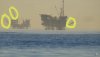
Next, wide awake turns to the left. There, he finds "Cutter Rock", more than 11 miles away (!) (see 12:45 in the video). The object doesn't move so it probably isn't a boat.

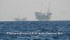
Just a little bit further to the left, we find the "Bayport Channel Entrance light" (18:10). This rack is very close to the camera (3.8 miles). The thing next to it is a boat.

I checked the locations of the platforms and the viewing angles on Google Earth and they appear to be consistent with the observations in the video:

However, it is not clear to me how we are supposed to see a rack that is 11 miles away. Remember the elevation of the camera relative to sea level is (2.5 ft) and Cutter Rock is not taller than 16 ft.
Source: https://www.youtube.com/watch?v=Kd_4a4I5BAs
This is what he did: he put his camera close to water level (approximately 2.5 ft) and tried to find distant platforms marking hazards such as submerged rocks. Apparently, this was done at the Gulf coast in Hernando County, Florida. Here is a list of the various platforms, providing a general description as well as GPS numbers:
https://www.floridagofishing.com/reefs/cw-reefs-hernando-county.html
None of the racks/platforms is taller than 16 ft.
The first platform is found at 9:00 in the video. Wide Awake identifies it as "Bayport North Rack", some 7.5 miles away. The image is heavily blurred, but the object is clearly stationary.
Next, wide awake turns to the left. There, he finds "Cutter Rock", more than 11 miles away (!) (see 12:45 in the video). The object doesn't move so it probably isn't a boat.
Just a little bit further to the left, we find the "Bayport Channel Entrance light" (18:10). This rack is very close to the camera (3.8 miles). The thing next to it is a boat.
I checked the locations of the platforms and the viewing angles on Google Earth and they appear to be consistent with the observations in the video:
However, it is not clear to me how we are supposed to see a rack that is 11 miles away. Remember the elevation of the camera relative to sea level is (2.5 ft) and Cutter Rock is not taller than 16 ft.