Oroville Dam Spillway Failure

Status
Not open for further replies.
No time for much detail, mostly conceptual,
Haven't had time to look at topography or geo map at this point (first image, road bend, post #506) What I see here are stress cracks , water stains still visible suggest very wet underneath, likely cause. The giant ogee weir is almost certainly a very robust structure IF foundation holds. The smaller longer rectangular is an area of concern. Clearly not expected to handle same flows as Ogee, hence less robust. Key issue here is elevation. Higher elevation is your friend, lacking that a problem area could be isolated with sandbags forming a diversion wall and pumping on the problem side of the sandbag diversion. Not pretty, but quick and, at least it lowers local hydraulic head and reservoir supply.
Understanding the problem is critical here , duct tape has it's uses , (not kidding, nor suggesting use here!) Plywood (and a bit of angle iron) extended the Glen Canyon Dam vertically and held back the entire Lake Mead (Lake Powell? poor geography, sorry) from overflowing the face of that dam. It raised the elevation of the entire lake substantially which increased reservoir volume enormously and bought them time. I mention this not as a particular technique, but as an example of clear conceptual thinking . The engineers knew at those low head pressures plywood absolutely could hold back the entire lake. No way to run a dam, under normal conditions, but, perfect in that situation.
Concepts here are channeling 100,000 cfs in a non destructive manner. Currently main spillway is doing that, that could change at any moment in a non-linear fashion . I choose 100,000cfs because it's been compared earlier to the Mississipi and Niagara flows. The big difference here from the Miss. is that the pitch from dam crest to river below is much steeper, additionally that hillside face hasn't been a well scoured riverbed anytime recentl, if ever. It's unlikely that there are many lasting examples of rivers of this flow that maintain an even grade with this much drop in this much horizontal distance .The erosion properties, including that rock alteration takes place sub-surface as well, and rock structure greatly influences resistance have been clearly described by Rock Whisperer. That hard bedrock also can form large hard coherent boulders which also act as very effective scouring and chiseling agents as they're propelled by water downhill.
Not exactly the right analog, but the concept of controlling a fire hose comes to mind, as well as the farther back on the hose from the nozzle one holds the squirrelier it gets. Control matters.
This is a very dynamic (including storm flows) situation.

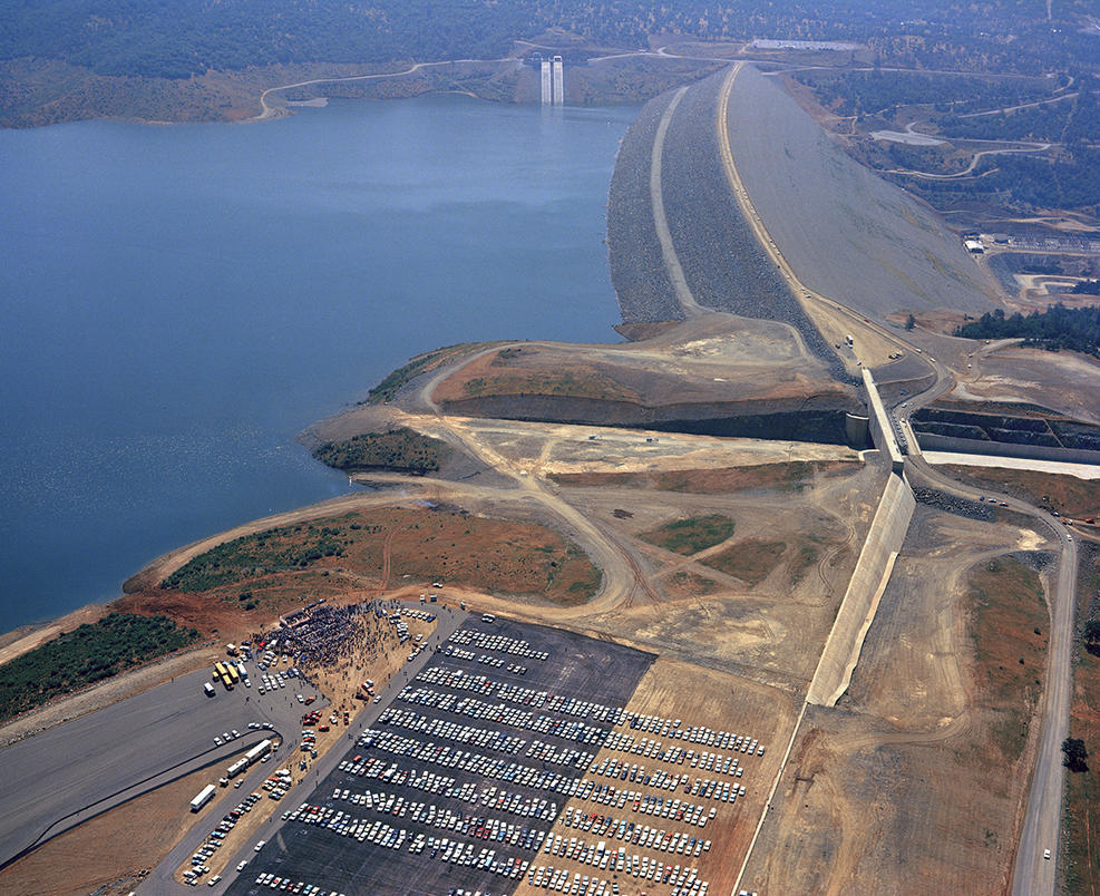
The problems with the parking lot section are serious - and being missed by most.

The concrete wall is NOT a weir - it is a narrow bit of concrete that sticks up one foot and is set just 2 feet in the ground.

"The right 800-foot section is a broad-crested weir on a bench excavation. "

More importantly the 800' parking lot section does NOT connect with higher ground. It stops at the access road to the parking lot. Water simply went around the end of the weir flowed down the inside ditch of the road and was cusing significant erosion all down the upslope side of the road. When that water reached a low enough road point it crissed over and help wash out the road.

If/when it actually washed out the road at the corner to turn into the parking lot - the road there is built of 30+ feet of fill. The down slope side is a big drop, which would have allowed a high volume flow to be drawn from around the parking lot weir.

That is why they are working so hard on the parking lot section.

That weir should be extended and until it reaches higher ground at back side of parking lot or it is both largely worthless and a significant failure point.

It was an issue even at 1.6 feet "head" above the 901 weir height ... the problem increases dramatically the higher the lake gets above 901
 
Just a few notes on the actual main spillway fracture plus two links on the oldest working dam in the world circa, 1309-1304 BC, showing its value for money. In my locality, a slightly newer dam built 1861.

I have reason to submit that the original fault in the emergency slipway has been caused by incorrectly angled concrete deck that caused suction due to release of compression as the water travelled downhill.

As one can see from the numerous photographs on this discussion, the angle of the slipway changes at about 40% down slope. The down flow of water under steady compression is forced to amplify speed causing the top 25-30% of down flow to increase speed thus causing a decompression or suction against the rest of flow. This suction at an estimated 200 metric tons per Square Meter would be sufficient to start a crack propagation phenomenon usually known as a subcritical crack. As it looks as if the concrete was not anchored via pilings etc at this area, the vertical stress would be sufficient to cause failure. Note that the failure is downhill of the actual angle change as it takes time for the decompression or suction effect to reach peak.

Extrapolating from the use of turbulators, etc. to manage flow separation on the topside of airfoils, is it reasonable to assume the "air ramps" shown on page #30 of http://www.damsafety.org/media/Docu...urcesByTopic/EMI_TS20_2013/PRESENTATION05.pdf are related to mitigating this concern?
 
More importantly the 800' parking lot section does NOT connect with higher ground. It stops at the access road to the parking lot. Water simply went around the end of the weir flowed down the inside ditch of the road and was cusing significant erosion all down the upslope side of the road. When that water reached a low enough road point it crissed over and help wash out the road.

20170215-163229-jo2t6.jpg

Looks like the weir wall continues under the road to me. I really don't think they would have overlooked the need to tie it into the hill back when it was all exposed.
 
The whole point of a weir wall like this is maintaining laminar flat flow over the area ... all flowing in one uniform depth and one direction - a flat, uniform sheet - so there are no concentrated flow points to begin erosion. The best way IMO would be to make the top bench below weir flat all the way across ... same with slope down to the road. Harden the bench, the slope to the road, the road base and the slope down from the road .... then let water take its course down the hillside - which we've seen can easily handle the flow ... being largely blue/green bedrock
I have wondered, why they didn't build the road at the base of the weir wall. Make it the "splash pad" at the base much like they are doing with the rocks and grout now and then make a loop out if needed to make the corner into the parking lot a wider turn.
It would seem like an excellent place for a "dual use" structure.

Aaron Z

It would be subject to degradation over time. The weir is under-engineered for the acre feet it must deal with.
 
New poster here.

Been following the Oroville situation since last Tuesday (I'm a bit south near Hangtown) and this site is by far the most detailed and least sensationalist. Great job!

Two questions,

1) has anyone said anything about the massive cliff (which looks to be loose earth and not rock) forming due to the erosion on the south side of the lower primary spillway and if there is a chance it will collapse and if so would it effect the integrity of the hillside that I would call the north shoulder of the dam?

2) Did anyone ever say what those two big bulldozers were doing below the dam on the north side of the river?
 
If the spillways are constructed on a sheeted dike complex (1), the large variances in rock type associated with this type of formation combined with faulting, folding, and low T metamorphism that occurred during obduction will result in areas of bedrock more prone to chemical weathering than others. The steeply dipping beds will enhance the downward migration of meteoric water, exasperating this differential weathering pattern. Being situated hundreds of feet above the river has left this bedrock exposed to the elements for a million years more or less and has led to chemically weathered bedrock extending far below the surface in places while inches away horizontally is fresh bedrock.

Even worse would be if the spillways are built into the unit stratigraphically above the sheeted dikes, metavolcanics intruded by the dikes (1). Pillow lavas with their chill margins are fragile when fresh, and are even more susceptible to chemical weathering than the dikes.

Diabase might be an incredibly strong rock when fresh, but not all of the main spillway is built directly on this competent bedrock as is evidenced by the original blowout and images of the spillways construction. There are many sections of the main spillway directly below the gates that were built on chemically weathered bedrock. With a 100k cfs flowing for the foreseeable future, with higher rates possible considering the long range forecasts, another blowout is a real possibility.

The emergency spillway is not auxiliary, and i don't believe any competent geologist present during it's construction would have considered its use as anything but a last ditch effort. It was designed as a fail-safe to prevent the loss of the main dam during the event of up to half a million cfs inflow to the lake during a 200 to 1000 year event. The ogee weir extending from the main spillway gates was likely built to protect the main spillway gates. The bedrock was excavated deeper below the ogee weir to find more competent bedrock than the concrete wall extending northwards from the ogee weir, which was built to protect the ogee weir. The lack of concrete in the far NW corner of the parking lot where we saw considerable erosion and helicopters lowering bags of rocks into is not lack of foresight, but designed weakness built into a weak structure. The parking lot is built on highly weathered bedrock and is designed to function as a sacrificial plug located as far from the dam itself as possible, similar to the Auburn coffer dam failure of 1986. As headcutting progresses into the parking lot, water at elevation 900 and above is skimmed off. Once headcutting reaches the lake, then downcutting commences, "safely" lowering the lake till competent bedrock is found, maybe a hundred feet down, leaving the vast majority of the lake still in the lake and Oroville dam still standing, no matter the magnitude of the storm.

The costs associated with building a sound "auxiliary" spillway due to the amount of bedrock that needed to be excavated to reach the competent stuff, probably discovered after work had begun, could have led to such a design. In the event that the emergency spillway saw huge flows (not a mere 12k cfs), the flows would hydraulically mine out the weak bedrock so that a future main spillway and gates could be constructed that actually would stand the test of time. This was before water quality standards for fish was a concern.

Footage of helicopters ferrying in bags of rock is made for TV “look, we are doing everything we can” But the bedrock on either side of the ravine they were filling is just as weak as what had been washed out. If water were to return, downcutting would simply erode either side of the reinforcements or choose another channel to erode. The only way to make this emergency spillway an auxiliary with how things currently stand is to rock armor and concrete nearly the entire hilltop, which is what I expect to see done over the course of the next few weeks. But even then, without excavating out the weathered bedrock across the entire emergency spillway to a depth similar to the ogee weir closest the main spillway gates, a blowout similar to the original will be a real possibility.

(1)http://earth.geology.yale.edu/~ajs/1980/ajs_280A_1.pdf/329.pdf


Re: the parking lot spillway section --- your comments are largely what I've noted - from a more layman perspective. I hadn't considered the sacrificial part but had identified the fundamental weakness fro not extending the parking lot weir (if you can even call it that) across the road at its outside end to connect with higher ground.

That said - IF - it is sacrificial it should have a control structure that gives them the CHOICE of when to deploy it. As it stands now that flow begins as soon as the spillway is breached.

I also came across the following which confirms the bedrock underlying the ogee weir ...

"In part of the emergency spillway, an additional 10 feet of excavation was required to reach acceptable foundation rock, resulting in considerable additional time for excavation and placement of the backfill concrete to subgrade. "

Find sound bedrock for the foundation of the emergency weir was an important consideration. And is extremely important to the discussion of head cut and the safety of the ogee weir.

If as this seems to make clear, the ogee weir is on strong bedrock foundation ... then the risk of head cut undermining it is minimal if at all. Even if a headcut reaches the weir - there is a 12' wide by 6'deep apron, or "toe" on the downslope side - which is sitting on bedrock. And if that did occur, there is appx 500 feet of shallow water - where soils are near top of weir - before reaching deeper water ...

And last - it appears they have filled the damage in the bench below the weir with large boulders and smaller fill, and then armored most of the bench with concrete - most of the way down to the road ... a good start

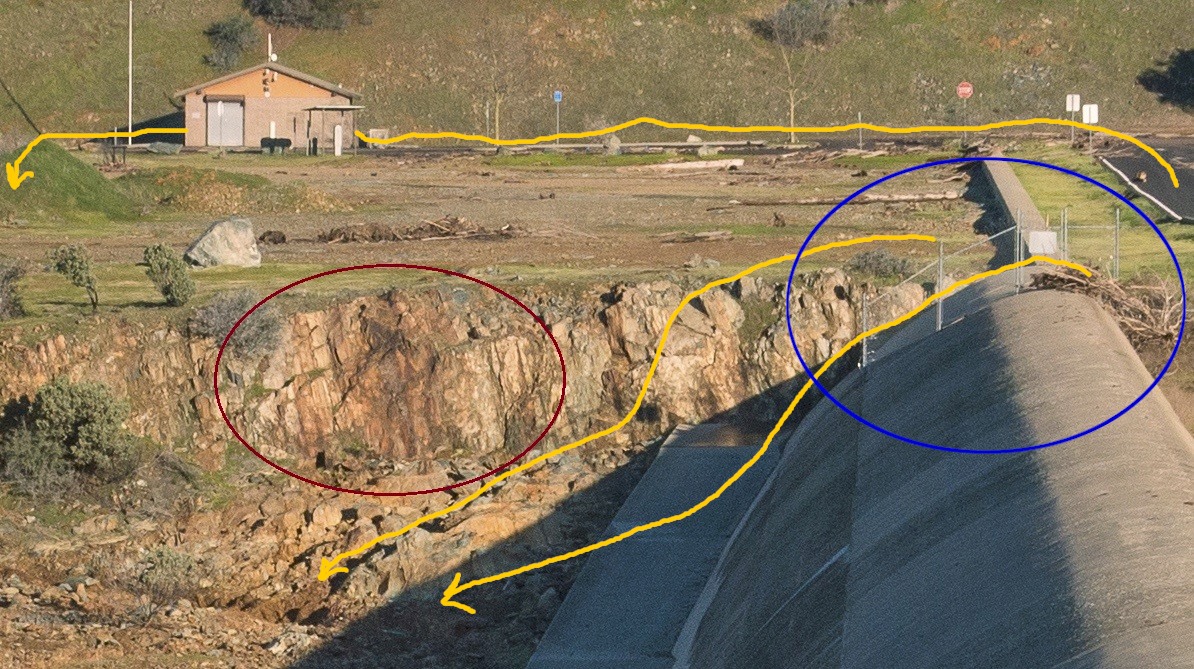
They should keep going and reestablish a flat level bench off the weir, than slope down to road level in the same flat slope (like it us from the parking lot weir to the road). As it stands they have concentrated the flow off the weir into several spots:


Also does not look like they have addressed the place the created the cross flows that caused the erosion to parking lot end of the bench - the connection between the ogee weir and the parking lot weir (blue and red circles) ...

 
Last edited:
1) has anyone said anything about the massive cliff (which looks to be loose earth and not rock) forming due to the erosion on the south side of the lower primary spillway and if there is a chance it will collapse and if so would it effect the integrity of the hillside that I would call the north shoulder of the dam?
The Erosion discussion has been split off to:
https://www.metabunk.org/oroville-dam-main-spillway-waterfall-erosion-watch.t8402/#post-200605


2) Did anyone ever say what those two big bulldozers were doing below the dam on the north side of the river?

Probably this:
http://www.chicoer.com/general-news...lle-dam?utm_source=dlvr.it&utm_medium=twitter

DWR is actively removing a debris bar that built up at the base of the main spillway in an effort to get the Hyatt Powerhouse under the dam back in operation. That will allow release of another 13,000 cubic-feet of water per second from the lake.

The debris forms something of a dam that has raised the water in the Diversion Pool to a level where the powerhouse can’t be operated. The deposit consists of chunks of concrete, rocks, dirt and vegetation that eroded from around the main spillway after its concrete floor breached on Feb. 7.

...

Sunday, heavy equipment cut a road to the water level on the south side of the Diversion Pool to make way from a giant excavator that was unloaded on the closed stretch of Oro Dam Boulevard above. A steady stream of gravel trucks moved in and out from the construction site.

Croyle said Sunday the plan was to put barges in the pool near the dam and scoop the debris into the barges. He said the spillway flow would not have to be cut off to do the work. Monday he said the work was underway.
Content from External Source
 
Well for 2) the channel was widening, they are trying to keep the flow from the generators fast and deep, less chance for sediment buildup. ( Just the thoughts of a mechanic)
 
I also came across the following which confirms the bedrock underlying the ogee weir ...

"In part of the emergency spillway, an additional 10 feet of excavation was required to reach acceptable foundation rock, resulting in considerable additional time for excavation and placement of the backfill concrete to subgrade. "

Where is that quote from?
 
It is what it is, when you live below a dam, it does not matter what the Army Corps of Engineers or CDWR is saying, take care of your self and family.
 
Thanks for pointing out the parking lot issue. Good eye. Missed that . Didn't have time to follow up earlier today . Agreed serious if goal is to release all water in a controlled fashion. Also agreed (that like all soils under flow and pressure,) the channel size can increase rapidly . Possible counterpoint is earlier described " safety"valve effect. Not personally looking forward to that kind of test.
Agreed with Mick that it likely continues westward beyond it's current surface exposure . In any case, it did appear (in the earlier air photo originally spotting it, #?) that the road in was fractured and the wet stains in the fracture suggest sub-surface moisture. Implication here, is that regardless of whether "rectangular weir" continues under road, somehow water is getting from reservoir side to road violating my sense of keeping res separated from independent outflows.....hence earlier commentary about effectiveness of barriers and pumping.
As has been said by many earlier, there may be some merit in having equipment , including pumps , staged in place at various locations with fuel . I can imagine channeling , and flows that might preclude movement of machinery, even very heavy capable machinery to where they might do the best good, even crucial, timely (timing is everything) good. Pretty easy to heli in an operator or twelve operators under most conditions. Don't imagine it's so easy to heli in a Cat D9.
 
Obviosuly they can't release ANY water through the spillway when the lake level get below the sill of the main spillway (Flood Control Outlet), which is 813.6 feet. The lake level also limits how much water will flow through the gate, regardless of how open the gates are. They simply can't do more than a certain amount when the lake is low - not to avoid damage, there just isn't the head of water.


I haven't been able to figure out what the grates below the main spillway on lake side go to ...

 
Is it only me who thinks that positioning of the two power line towers is faulty as being so close to the main spillway?
In case of emergency spillway use, there's still a chance that water flows to their direction and washes them out. In case they fall towards the main spillway, I'm pretty sure that creates some damage to the spillway concrete, just enough to initiate a crack.

Water from emergency spillway would have to travel long way uphill to reach those elec towers
 
20170215-163229-jo2t6.jpg

Looks like the weir wall continues under the road to me. I really don't think they would have overlooked the need to tie it into the hill back when it was all exposed.


Great picture ... seems to illustrate same point though. Raising the road and parking lot above the weir defeats the purpose of the weir it would seem.

Remember too - the lake level increases higher than the top of the weir and a proper weir still acts as a restriction (although the parking lot weir is not proper in most any way). When you provide a smooth flat sheet there is unrestricted flow ... water will gravitate to the path of least resistance.

This seems even worse to me?
 
and you 'know' this how?
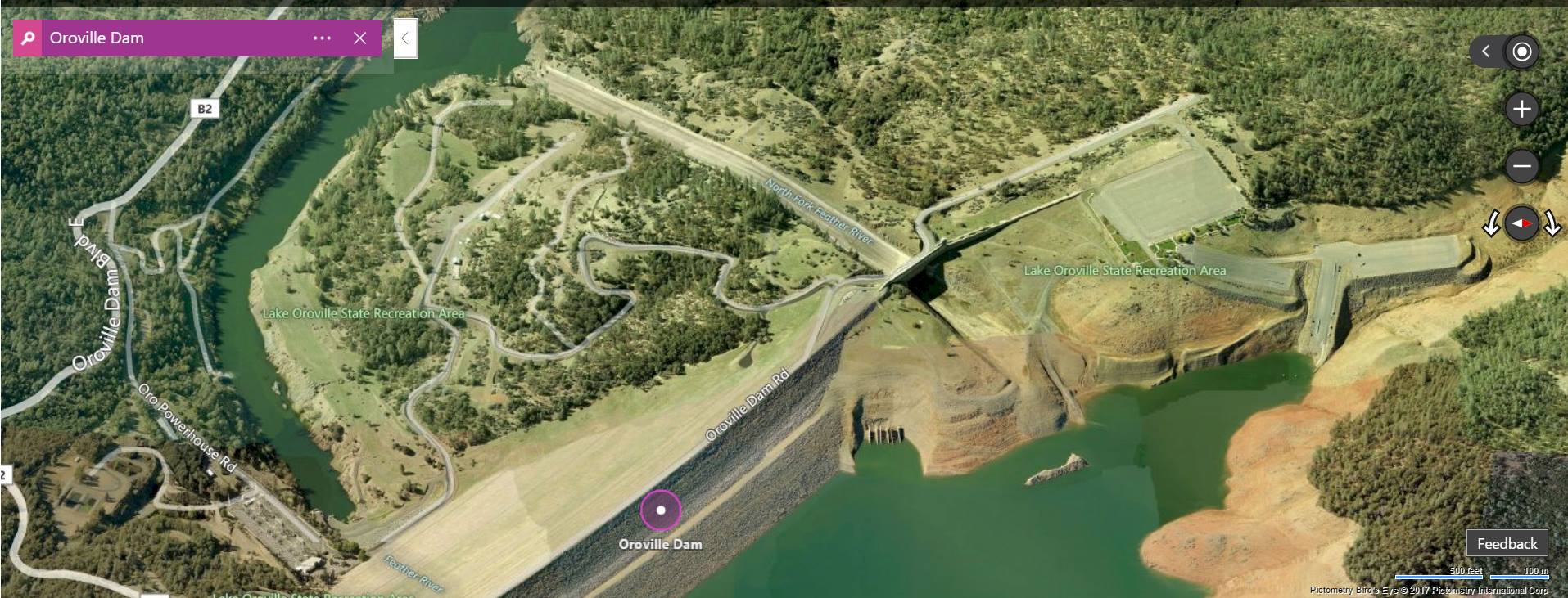
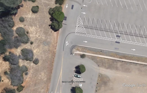
GE image showing the concrete wall ending. Perhaps it extends under the launch ramp entrance road, but does not penetrate the hillside. The hillside is orange, indicative of weathered bedrock, that, as we have seen, can erode quickly.
upload_2017-2-15_16-20-39.png

The parking lot in 1968 has not been fully paved. There is very little fresh bedrock (gray) and a lot of weathered bedrock (orange and red hues). The fresh bedrock is exposed best at the base of the ogee weir closest to the main spillway gates, where the weir is most deeply excavated into the ridge. Now notice the orange hues towards the northern end of the weir just downstream, in the location the headcutting most closely approached the weir. Note the chosen location to terminate the ogee weir is at a location with a zone of fresh bedrock (darker gray). Now follow the concrete wall a short ways into red hues again, a likely candidate for a breach to begin.


Now watch this video below. Imagine instead of a coffer dam, it was the main spillway gates that they want to protect. Instead of a sacrificial plug in a manmade dam, there is a large wedge of weathered bedrock. Keep in mind how much erosion we've already seen occur at the mere 15k cfs flowing down the emergency spillway, vs 100, 200, or even 500k cfs it was designed for.
Lets pretend for a minute the flow is a 100k cfs over the e spillway, with a head of some number x feet of water over the e spillway, maybe 5 feet. Ill crunch the numbers later. Also for this demonstration imagine the weir doesnt fail. Flows will headcut around the low concrete wall, progressing through the parking lot with very little change to lake level. Once deep water is reached, the second phase of erosion will proceed, where flows greatly increase, erosion rates increase, and the flow will hydraulically mine its way down to competent bedrock and the lake level stabalizes.

Source: https://www.youtube.com/watch?v=tDmwo5nsWfQ


P.S. The Rock Whisperer is currently accepting geology job offers or graduate research assistantships.
 
Great picture ... seems to illustrate same point though. Raising the road and parking lot above the weir defeats the purpose of the weir it would seem.

Remember too - the lake level increases higher than the top of the weir and a proper weir still acts as a restriction (although the parking lot weir is not proper in most any way). When you provide a smooth flat sheet there is unrestricted flow ... water will gravitate to the path of least resistance

The "weir" there is about 1' high, a bit of road going over one bit of it isn't going to do anything.
 
GE image showing the concrete wall ending. Perhaps it extends under the launch ramp entrance road, but does not penetrate the hillside. The hillside is orange, indicative of weathered bedrock, that, as we have seen, can erode quickly.
upload_2017-2-15_16-20-39.png

The parking lot in 1968 has not been fully paved. There is very little fresh bedrock (gray) and a lot of weathered bedrock (orange and red hues). The fresh bedrock is exposed best at the base of the ogee weir closest to the main spillway gates, where the weir is most deeply excavated into the ridge. Now notice the orange hues towards the northern end of the weir just downstream, in the location the headcutting most closely approached the weir. Note the chosen location to terminate the ogee weir is at a location with a zone of fresh bedrock (darker gray). Now follow the concrete wall a short ways into red hues again, a likely candidate for a breach to begin.


Now watch this video below. Imagine instead of a coffer dam, it was the main spillway gates that they want to protect. Instead of a sacrificial plug in a manmade dam, there is a large wedge of weathered bedrock. Keep in mind how much erosion we've already seen occur at the mere 15k cfs flowing down the emergency spillway, vs 100, 200, or even 500k cfs it was designed for.
Lets pretend for a minute the flow is a 100k cfs over the e spillway, with a head of some number x feet of water over the e spillway, maybe 5 feet. Ill crunch the numbers later. Also for this demonstration imagine the weir doesnt fail. Flows will headcut around the low concrete wall, progressing through the parking lot with very little change to lake level. Once deep water is reached, the second phase of erosion will proceed, where flows greatly increase, erosion rates increase, and the flow will hydraulically mine its way down to competent bedrock and the lake level stabalizes.

Source: https://www.youtube.com/watch?v=tDmwo5nsWfQ


P.S. The Rock Whisperer is currently accepting geology job offers or graduate research assistantships.


Yes: "the flow will hydraulically mine its way down to competent bedrock and the lake level stabilizes"
 
Last edited by a moderator:
[The crux of the matter would seem to be why has erosion stopped ?

Headward migration has encountered competent bedrock again. There are more zones of weathered bedrock underlying the spillway between the original blowout and the gates. The spillway may fail in another spot without needing to headcut its way up. I'm sure DWR is dreading the prospect of a tell tale rooster tail appearing closer to the main gates. They will have eyes on it 24/7, ready to close the gates at a moments notice.[/QUOTE]


Pictures and comments here show very narrow seams of fractured rock further up the spillway. But they are perpendicular to the water flow and again very narrow ... spillway concrete bridges these narrow bands - would seem they are not a threat?
 
I'm sure the answer to the following question is in here somewhere but I haven't found it. I understand that the lip of the Emerg spillway at 901 ft is 21 feet below top of dam. Question: What is the height of the base of the primary/regular spillway? When water flows? It is tough getting perspective from pictures but is it perhaps 850' or so?
Thanks for the GREAT site, I'm learning a lot.
 
Differences in inflow, outflow, etc. for the "same" flow likely to be result of different instruments, locations, or methods of measure (modeling v. gage, etc.). Not necessarily a bad thing as redundancy and multiple readings of the same thing is a handy tool for calibrating and verifying data....another possible explanation, increased sources downstream provide higher totals....another explanation, data based on model, as earlier weir estimations here were and could come up with inexact but still useful data. Often direction of rate changes or stability are more important than precision to the teaspoon.
Quick flipside on that is that discrepent measurements may be indicating something highly worthy of your attention. Typically operators will have a highly tuned sense of what's reassuring (say right ballpark) and what's off kilter or alarming.
Back to data at 1600 (4:00pm) lake elevation = ~ 875 . Wednesday ends at midnight. I'm having trouble seeing how the 50' dump goal by DWR as quoted in the LA Times a bit back will be met. Could well be a misquote . That happens all the time, even back in the day when we used to have widespread edited print journalists. If not something like that, I'm hoping it's not reflective of excessive optimism . Personally,I'm DAM happy to see the lake at 875' rather than 901'+, and I'm DAM happy to see the concrete spillway operational and flowing at 100,000cfs and not currently (I hope with all my hope) incising headward. Those are real accomplishments.
 
I'm sure the answer to the following question is in here somewhere but I haven't found it. I understand that the lip of the Emerg spillway at 901 ft is 21 feet below top of dam. Question: What is the height of the base of the primary/regular spillway? When water flows? It is tough getting perspective from pictures but is it perhaps 850' or so?
Thanks for the GREAT site, I'm learning a lot.
Mick posted 813.6' earlier today:
Obviosuly they can't release ANY water through the spillway when the lake level get below the sill of the main spillway (Flood Control Outlet), which is 813.6 feet. The lake level also limits how much water will flow through the gate, regardless of how open the gates are. They simply can't do more than a certain amount when the lake is low - not to avoid damage, there just isn't the head of water.


Aaron Z
 
I don't have the cite handy, but the isostatic depression after filling the reservoir from empty was about 5cm.

Here's the source I was thinking of - but it turns out the 5cm figure:

a) Is modeled, not measured (although this is a straighforward computation)
b) reflects elastic accommodation in the lithosphere, not isostatic compensation

Beck, J. L. "Weight-induced stresses and the recent seismicity at Lake Oroville, California." Bulletin of the Seismological Society of America 66.4 (1976): 1121-1131.

With several cases of reservoir-induced activity already documented, it is natural to inquire whether the Oroville seismicity was due to the presence of the reservoir. As part of such a study, the stresses induced in the neighboring lithosphel:e by the weight of Lake Oroville are determined. On the basis of present geological data, it is unlikely that these stresses were responsible for the main shock of August 1, 1975. The weight-induced shear stress across the fault plane in the hypocentral region has a component of about 0.04 bar parallel to the reported fault movement but in opposition to this movement. The greatest weightinduced shear stress is about 3.4 l~ars and this occurs under the deepest portion of the lake. The greatest vertical deflection at the surface due to the weight of Lake Oroville is calculated to be about 5.5 cm.


I can make a quick attempt at isostatic compensation estimation. Someone should double check my work here - it's been a while.

The mass of water emplaced at full pool is
An equal additional buoyant force is required to achieve isostatic equilibrium.
The buoyant force is proportional to the volume of lithosphere displaced downward and the local density contrast between the lithosphere and the asthenosphere. These will be on the order of 2600kg/m^3 and 3300kg/m^3, respectively.
(3300kg-2600kg)/m^3 = 700kg/m^3, so there is a buoyant force of per m^3 of lithosphere depressed.
4.317*10^15g / 7*10^5g/m^3 = 6.1*10^9m^3

If the lithosphere directly beneath the lake had no shear strength, so the lake could press a lake-shaped plug straight down, you'd be looking at (yes, really) of isostatic depression. However, the rigidity of the lithosphere means the weight really is spread out over a 100km+ radius. The deflection would be 5cm for a 180km radius area.

tl;dr My source was referring to elastic deformation of the lithosphere, but isostatic depression would be of the same order of magnitude.
 
Last edited:
thanks im good with the bedrock. i just cant grasp the term "sacrificial plug" in the context of what you are saying. Must be a male/female thing.
Watch the youtube video with the sound on and listen. Around 30 seconds in, it is described as a "safety plug, a soft plug" purposefully built in. One that would purposefully erode away in a sacrificial manner. Continue watching the video to see how such a weak spot can be used to safely release water before the flows increased dramatically hours later. Those hours give precious time for evacuations.
 
The "weir" there is about 1' high, a bit of road going over one bit of it isn't going to do anything.

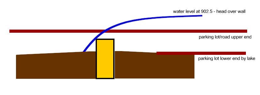
I may be wrong - but a weir - even that sorry excuse for a weir ;-) - still restricts a head elevation even well above its height - once the head height gets to the raised road elevation a portion of the head can flow smoothly without restriction - which will then be the path of least resistance ...

A crude illustration ;-)

 
Elevation is everything here. I do see bouyant debris that stopped there. reckon a photo at 902.5' lake elevation would give an excellent topographic bath tub ring. An oblique high resolution shot would probably show what's high ground.
 
The parking lot mini-weir does seem to go under the road. I'm pretty sure they would have attached it to the hillside. Photo from today:
http://pixel-ca-dwr.photoshelter.co...Kk/DK-Oro-Spillway-damage-4109-02-15-2017-jpg
20170215-170533-4uuxk.jpg

20170215-170811-u0lt3.jpg


These pics seem to demonstrate exactly what I was saying ... despite the lake level being above the parking weir by 1.58 feet (902.58) the debris floated up to the road around the corner and then back downslope at an angle ... which would indicate that was the direct of the current created
 
have they? or are you thinking of the media doing that?


can you link to that? That they thought DWR would use it as an auxilliary spillway?(not media reports, actual evidence of that).

Emergency Spillway: A spillway that is designed to provide additional protection against overtopping of dams, and is intended for use under extreme flood conditions or misoperation or malfunction of the service spillway and/or the auxiliary spillway

https://www.ferc.gov/industries/hydropower/safety/guidelines/fema-94.pdf
Content from External Source
http://www.ceskatelevize.cz/ct24/sites/default/files/1874807-prehrada.pdf
The whole thing is worth reading, but the detailed discussion starts at page 14, in particular @20-22.
 
Thirty-three cases of upstream slips were collected
and a third of them were attributed to an excessively
rapid drawdown of the reservoir. A significant case
was San Luis dam, in California (ICOLD, 1980).
San Luis dam is one of the largest earthfill dams in
the world (100 m high;5500 m long; 70 million m3
of compacted embankment). An upstream slide de-
veloped in 1981 after 14 years of successful opera-
tion of the dam because of a drawdown, which was
more intense than all the previous ones. In this case,
the average drawdown rate was around 0.3 m/day
and the change in reservoir level reached 55 m.

Here is another reason for slowing down the release of water from the reservoir. If you drop it too quickly you risk the lake side of the dam having slumping problems. I'm sure the engineers are aware of this problem.
 
Status
Not open for further replies.
Back
Top