If the spillways are constructed on a sheeted dike complex (1), the large variances in rock type associated with this type of formation combined with faulting, folding, and low T metamorphism that occurred during obduction will result in areas of bedrock more prone to chemical weathering than others. The steeply dipping beds will enhance the downward migration of meteoric water, exasperating this differential weathering pattern. Being situated hundreds of feet above the river has left this bedrock exposed to the elements for a million years more or less and has led to chemically weathered bedrock extending far below the surface in places while inches away horizontally is fresh bedrock.
Even worse would be if the spillways are built into the unit stratigraphically above the sheeted dikes, metavolcanics intruded by the dikes (1). Pillow lavas with their chill margins are fragile when fresh, and are even more susceptible to chemical weathering than the dikes.
Diabase might be an incredibly strong rock when fresh, but not all of the main spillway is built directly on this competent bedrock as is evidenced by the original blowout and images of the spillways construction. There are many sections of the main spillway directly below the gates that were built on chemically weathered bedrock. With a 100k cfs flowing for the foreseeable future, with higher rates possible considering the long range forecasts, another blowout is a real possibility.
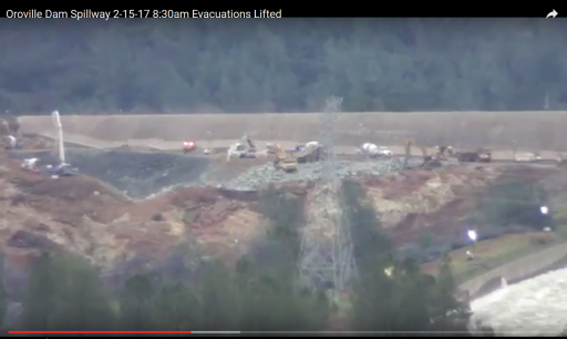
The emergency spillway is not auxiliary, and i don't believe any competent geologist present during it's construction would have considered its use as anything but a last ditch effort. It was designed as a fail-safe to prevent the loss of the main dam during the event of up to half a million cfs inflow to the lake during a 200 to 1000 year event. The ogee weir extending from the main spillway gates was likely built to protect the main spillway gates. The bedrock was excavated deeper below the ogee weir to find more competent bedrock than the concrete wall extending northwards from the ogee weir, which was built to protect the ogee weir. The lack of concrete in the far NW corner of the parking lot where we saw considerable erosion and helicopters lowering bags of rocks into is not lack of foresight, but designed weakness built into a weak structure. The parking lot is built on highly weathered bedrock and is designed to function as a sacrificial plug located as far from the dam itself as possible, similar to the Auburn coffer dam failure of 1986. As headcutting progresses into the parking lot, water at elevation 900 and above is skimmed off. Once headcutting reaches the lake, then downcutting commences, "safely" lowering the lake till competent bedrock is found, maybe a hundred feet down, leaving the vast majority of the lake still in the lake and Oroville dam still standing, no matter the magnitude of the storm.
The costs associated with building a sound "auxiliary" spillway due to the amount of bedrock that needed to be excavated to reach the competent stuff, probably discovered after work had begun, could have led to such a design. In the event that the emergency spillway saw huge flows (not a mere 12k cfs), the flows would hydraulically mine out the weak bedrock so that a future main spillway and gates could be constructed that actually would stand the test of time. This was before water quality standards for fish was a concern.
Footage of helicopters ferrying in bags of rock is made for TV "look, we are doing everything we can" But the bedrock on either side of the ravine they were filling is just as weak as what had been washed out. If water were to return, downcutting would simply erode either side of the reinforcements or choose another channel to erode. The only way to make this emergency spillway an auxiliary with how things currently stand is to rock armor and concrete nearly the entire hilltop, which is what I expect to see done over the course of the next few weeks. But even then, without excavating out the weathered bedrock across the entire emergency spillway to a depth similar to the ogee weir closest the main spillway gates, a blowout similar to the original will be a real possibility.
(1)
http://earth.geology.yale.edu/~ajs/1980/ajs_280A_1.pdf/329.pdf

