
You are using an out of date browser. It may not display this or other websites correctly.
You should upgrade or use an alternative browser.
You should upgrade or use an alternative browser.
Stunning views of both sides of a cloud layer
- Thread starter Balance
- Start date
Jason
Senior Member
Breath taking video, thanks for sharing. Absolutely beautiful. I couldn't help but think about how the people below the cloud cover were thinking how crappy their day was due to cloud cover, yet the person(s) flying this plane were able to enjoy the sun and the sky in all its glory. Is this from your own experience as in were you flying this plane, and if so where was this video taken from. It also seemed a little nerve wracking when the pilot dipped below the clouds with an impending Mountain in front of them. Just incredible view(s)..
Beautiful video. I remember when I was 12 or 13 being taken up in a microlight and ascending through a gap in the murky grey English cloud into what looked like a bright white mountainscape with brilliant blue sky above. Just a few thousand feet up but it's a different world up there!
(Possibly it was somewhat less than legal, from what I now know of VFR rules, so we won't name names!)
(Possibly it was somewhat less than legal, from what I now know of VFR rules, so we won't name names!)
Last edited:
cloudspotter
Senior Member.
Shouldn't this be in the Useful debunking images thread?
WeedWhacker
Senior Member
Shouldn't this be in the Useful debunking images thread?
Not sure. A "Go-Cam" (or similar) mounted on the glareshield of an airliner. Yeah, it's beautiful. NOT a view that most people will get (unless they are airline pilots).
Our own member 'TWCobra' made a MOST excellent video as well. Just sayin'....(AND not to distract from the posting of this, by 'Balance'....ALWAYS great, each and every time, mate!!!).
Running off to find 'TWCobra's' video:
FOUND IT!!!:
https://www.metabunk.org/threads/flight-deck-video.3227/
WeedWhacker
Senior Member
Shouldn't this be in the Useful debunking images thread?
Follow-on comment.
What I saw in the video was a low-level stratus layer in a mountainous region....really, quite common in that sort of geography. When there is mountainous terrain surrounding a valley, and the airport is located IN that valley, or nearby area.
Member 'MikeC' (who lives in NZ) is quite familiar with that part of his country. If you'd like, I could look it up. (The airport and IFR Approach Procedures, etc). But, perhaps 'MikeC' should take "lead" (?)
WeedWhacker
Senior Member
Mountains at SFO aren't that impressive either.
East of SFO...around Lake Tahoe.....they are. Sorry, but I've seen the view from "the front" far too many times. Just doesn't compare to what can be seen "from the side"....
A320. And looks like it's about 8xDoes anyone know what type of plane was piloted in the OP? And was the time sped up?
Ray Von Geezer
Senior Member
My thoughts exactly. I got a little bit of buttock clench just watching it go into the cloud with all the mountaintops around. Fair play to the pilots who do that day in, day out.2:51: I was thinking, I sure hope he knows what's below him.
Ray Von
Jason
Senior Member
I was wondering what do pilots use to navigate through the clouds in tight spaces like this. Would they soley be relying on GPS since there's a river that runs through the canyon there and in the direction towards the runway, or do onboard computers navigate that environment. I could only imagine how difficult that track would be if the clouds covered the mountains in their entirety. Would be pretty scary or intense I would imagine?My thoughts exactly. I got a little bit of buttock clench just watching it go into the cloud with all the mountaintops around. Fair play to the pilots who do that day in, day out.
Ray Von
Jason
Senior Member
I'm not sure what or how this video could be used as a debunking tool. Would this be useful to help explain how low contrails can form in mountainous areas?Shouldn't this be in the Useful debunking images thread?
I was wondering what do pilots use to navigate through the clouds in tight spaces like this. Would they soley be relying on GPS since there's a river that runs through the canyon there and in the direction towards the runway, or do onboard computers navigate that environment. I could only imagine how difficult that track would be if the clouds covered the mountains in their entirety. Would be pretty scary or intense I would imagine?
Their GPS display would show them the terrain, and warn them if they were likely to hit it. But they should also be able to navigate just with the charts and the airport's VOR radio beacon.
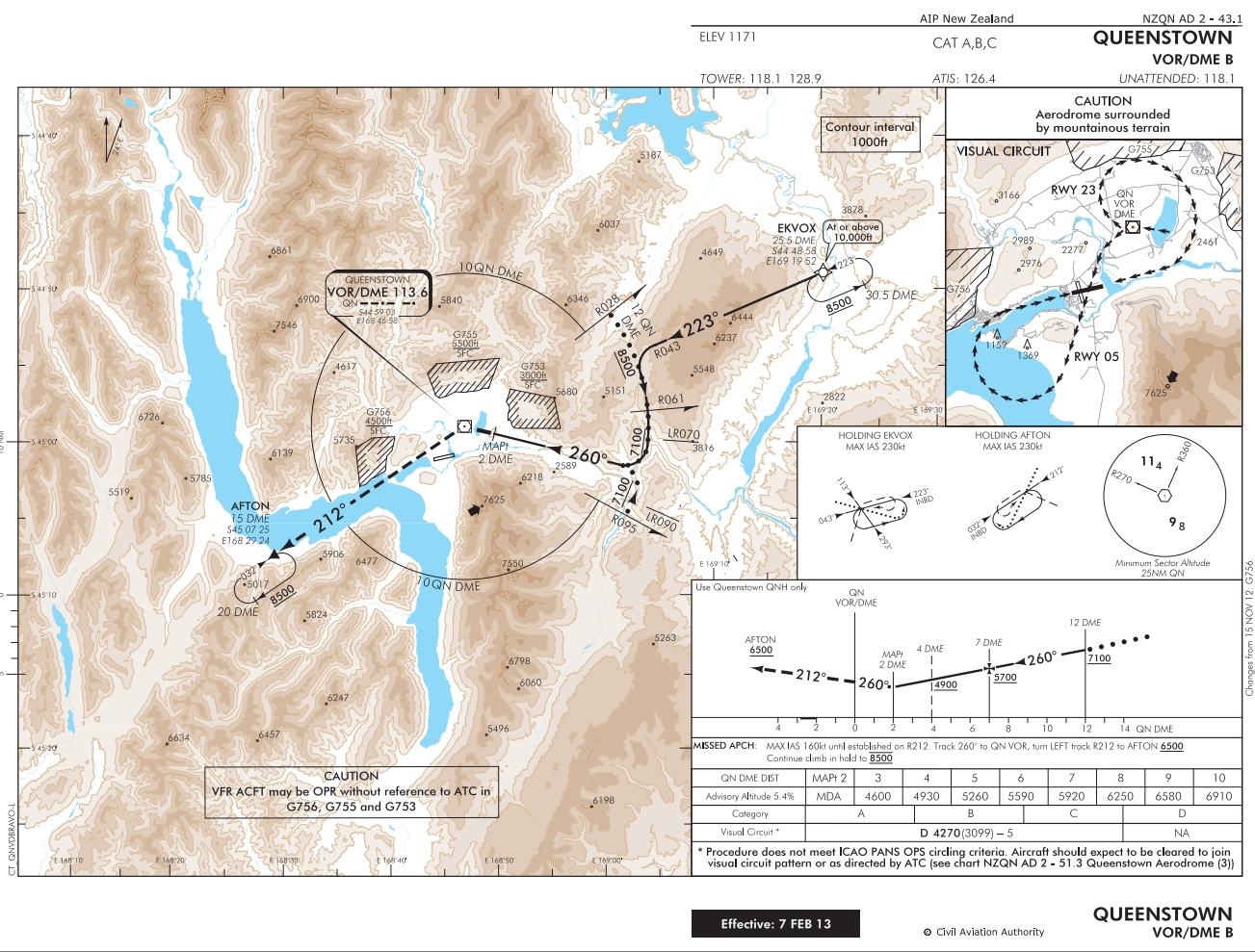
http://www.aip.net.nz/pdf/NZQN_43.1_43.2.pdf
http://www.aip.net.nz/NavWalk.aspx?section=CHARTS&tree=Queenstown
scombrid
Senior Member.
East of SFO
I said AT so the high Sierra don't count. And the marine layer analogy doesn't apply in the Sierra. Still cool to lift off from SFO in the AM and rise up through that murk and pop into the bright sun and see the little coastal hills peeking up above the fluff. Would be awesome to see it from the front but the cattle car view isn't bad sometimes.
One time the pilot of a connecter from Bellingham to Salt Lake City gave us a really cool view of Mount Rainier. Flight path was pretty much straight south from Bellingham with a left turn at Rainier. Left side of the airplane got a great look. Almost felt like you could reach out and touch the peak.
Last edited:
Jason
Senior Member
Are pilots allowed to record video from the cockpit at will or do they need to get special permission from their company or FAA? I've seen similar videos to this one, and I was curious if pilots are allowed to just mount cameras where ever they please in the cockpit to capture these images. Are these almost always the result of the pilot or co-pilots' desires, or can passengers ask the pilot (or stewardesses) to film, or can a passenger contact the airline company if they wish to make a similar video on an upcoming flight.
cloudspotter
Senior Member.
I'm not sure what or how this video could be used as a debunking tool. Would this be useful to help explain how low contrails can form in mountainous areas?
As Balance mentioned in the OP it's a good demonstration of changing atmospheric conditions over a short distance. Believers will often dismiss claims by debunkers that conditions can vary that much.
WeedWhacker
Senior Member
Are pilots allowed to record video from the cockpit at will or do they need to get special permission from their company or FAA? I've seen similar videos to this one, and I was curious if pilots are allowed to just mount cameras where ever they please in the cockpit to capture these images.
You might want to ask TWCobra. I expect that a small "GoPro" cam just sitting on the glareshield (or otherwise mounted) is certainly not intrusive (in terms of limiting the pilots' view). Of course, the key thing here is to NOT identify your company, lest you leave something open for possible.....who knows what?
Since this instance was NOT under the jurisdiction of the FAA, then that question is moot. (I expect though.....the FAA is a bit hard-assed about this....they just enacted a new rule to prohibit pilots from using their personal laptops...ironic, since the innovation of the "Electronic Flight Bag" means that pilots now use iPads or similar 'tablets'....).
TWCobra
Senior Member.
It is called an RNP approach (Required Navigational Performance) that for Queenstown requires special procedures, equipment and training.
Qantas was very involved in this; they may have been the first airline approved to do it. The real fun part is the engine failure at V1 case, where the "escape" procedures require flying down valleys in order to get to safety height. They aren't allowed to do these approaches/takeoffs at night.
Here is some very good information, which also references the OP video.
As far as using Go-pros are concerned, I haven't needed special permission but I do make sure the mounts I use are industrial strength, for obvious reasons. There are a lot of these videos around now and maybe the airlines recognise the value in them.
Jason
Senior Member
Love the GE report, and got to tip my hat to Mr. Fulton, especially when he discussed the difficult terrain on his landing approach in Alaska here;It is called an RNP approach (Required Navigational Performance) that for Queenstown requires special procedures, equipment and training.
Qantas was very involved in this; they may have been the first airline approved to do it. The real fun part is the engine failure at V1 case, where the "escape" procedures require flying down valleys in order to get to safety height. They aren't allowed to do these approaches/takeoffs at night.
Here is some very good information, which also references the OP video.
As far as using Go-pros are concerned, I haven't needed special permission but I do make sure the mounts I use are industrial strength, for obvious reasons. There are a lot of these videos around now and maybe the airlines recognise the value in them.
TW how true is this, have you ever flown into this airport prior to the RPN because he makes it seem somewhat of an obstacle if he missed his approach. Almost as if there wasn't a plan if they missed it.External Quote:TK: What if you missed?
SF: If a missed approach was required at any point along that last 90 seconds of visual flight to the runway, there was no published escape route. Each pilot had in their mind a plan, but for each of us it consisted of maximum go-around thrust in a climbing 180 degree, minimum radius turn in the darkness until safely above the terrain.
More than once I inadvertently descended into unseen clouds in the darkness and lost visual contact with the runway lights in this portion of the flight where visual contact was essential.
TWCobra
Senior Member.
I have only flown into that airport in my Air Force days which wasn't in a jet.
Mountain flying is a great teacher though. Pilots must always have a plan B ready to go.
There were airstrips I flew into, particular in Papua New Guinea, where you were committed to landing at a certain point.. Ie no go around available. This tends to concentrate the mind!
The difference here is that this operation is a scheduled service with paying passengers and the rules are necessarily more stringent. You must always have an escape route.
Mumbles
Active Member
It is called an RNP approach (Required Navigational Performance) that for Queenstown requires special procedures, equipment and training.
Qantas was very involved in this; they may have been the first airline approved to do it. The real fun part is the engine failure at V1 case, where the "escape" procedures require flying down valleys in order to get to safety height. They aren't allowed to do these approaches/takeoffs at night.
Not sure if RNP applied at the time (although from the description of the weather it might), but a Pacific Blue Captain was prosecuted recently mainly for operating outside the times/daylight conditions permitted:
http://www.nzherald.co.nz/nz/news/article.cfm?c_id=1&objectid=10873866
Last edited:
Jason
Senior Member
Here's what an approach into Queenstown looked like mostly without clouds in 1996. Love the thrust reversing system on the JT-8 powered 737's. Noting also the sundogs and vortices at various points.
Just another stunning view, how in the world did they get a camera on the tail of the plane? That would have to be bolted on wouldn't it?
Mumbles
Active Member
Just another stunning view, how in the world did they get a camera on the tail of the plane? That would have to be bolted on wouldn't it?
Yup, Air New Zealand engineering would have been involved in mounting the camera. There may have been some stories about it at the time, but this is the first time I've seen the footage.
At the risk of going off topic for those interested there are also videos of approaches into Wellington and Christchurch. The Wellington one is interesting for me as it's where I live, and the city flyover is notably absent of a couple of landmark structures built in the late 90's. The Christchurch one doesn't go over the city but the changes both since 1996 and 2011 in particular would be more stark if it did.
Wellington:
Christchurch:
derwoodii
Senior Member.
Its often cheaper to fly to Queenstown NZ go spring skiing than drive up the pimples we call mountains in OZ
$269.00 10:00 AM, Tuesday 04 November 2014
$269.00 10:00 AM, Tuesday 04 November 2014
- Melbourne (Tullamarine) - International Terminal - T2
to Queenstown - Domestic TerminalJetstar Airways
Mumbles
Active Member
I have only flown into that airport in my Air Force days which wasn't in a jet.
Caribou?
Mumbles
Active Member
Its often cheaper to fly to Queenstown NZ go spring skiing than drive up the pimples we call mountains in OZ
$269.00 10:00 AM, Tuesday 04 November 2014
But im going cat sailing at Whitsundays that week
- Melbourne (Tullamarine) - International Terminal - T2
to Queenstown - Domestic TerminalJetstar Airways
By the same token it's often cheaper to fly to Aus from Wellington than to Qtown - I once spent a weekend at an airshow in Sydney for less than what it would have cost to do the same for the Wanaka airshow. In fact one of my flights to Queenstown for Wanaka this year cost more in NZD than the one you have here.
TWCobra
Senior Member.
Caribou?
Yes. We often flew to NZ to practice mountain flying. Flying in Milford Sound was probably the most spectacular experience one could hope for.
http://www.flytime.ca/beautiful-approach-landing-milford-sound-airport-new-zealand
Ross Marsden
Senior Member.
TWCobra, I was at RNZAF Base Auckland met office (MetService, not RNZAF) between about 1990 and 1997.
We may have met. I recall a visiting Caribou flight line along by SQN42 who hosted you.
We may have met. I recall a visiting Caribou flight line along by SQN42 who hosted you.
Similar threads
- Replies
- 6
- Views
- 3K
- Replies
- 101
- Views
- 27K
- Replies
- 3
- Views
- 4K
- Replies
- 129
- Views
- 29K
- Replies
- 34
- Views
- 17K