6 Giant Towers discovered on the Moon [Digital Artifacts/Glitches]

HoaxEye

New Member
I'm not sure if this is the correct forum for this topic. Feel free to move around if needed.

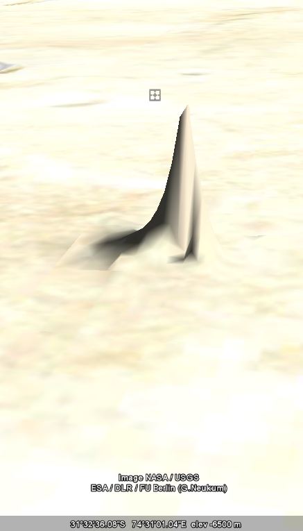
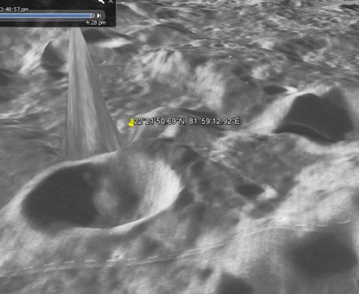
I would like to debunk one claim made by a YouTube UFO channel called Secureteam 10 in a video titled as: "6 GIANT Towers Discovered On The Moon 3/31/17". There is no need to watch the video, because it contains other, unrelated claims as well.

The channel claims they have found at least six "towers" from the moon via Google Earth/Moon. They give coordinates of two:
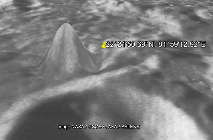
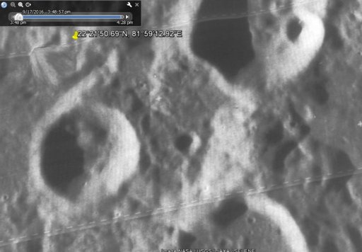
1. 22°21'50.69"N, 81°59'12.92"E
2. 16°17'20.57"N, 87°36'23.56"E

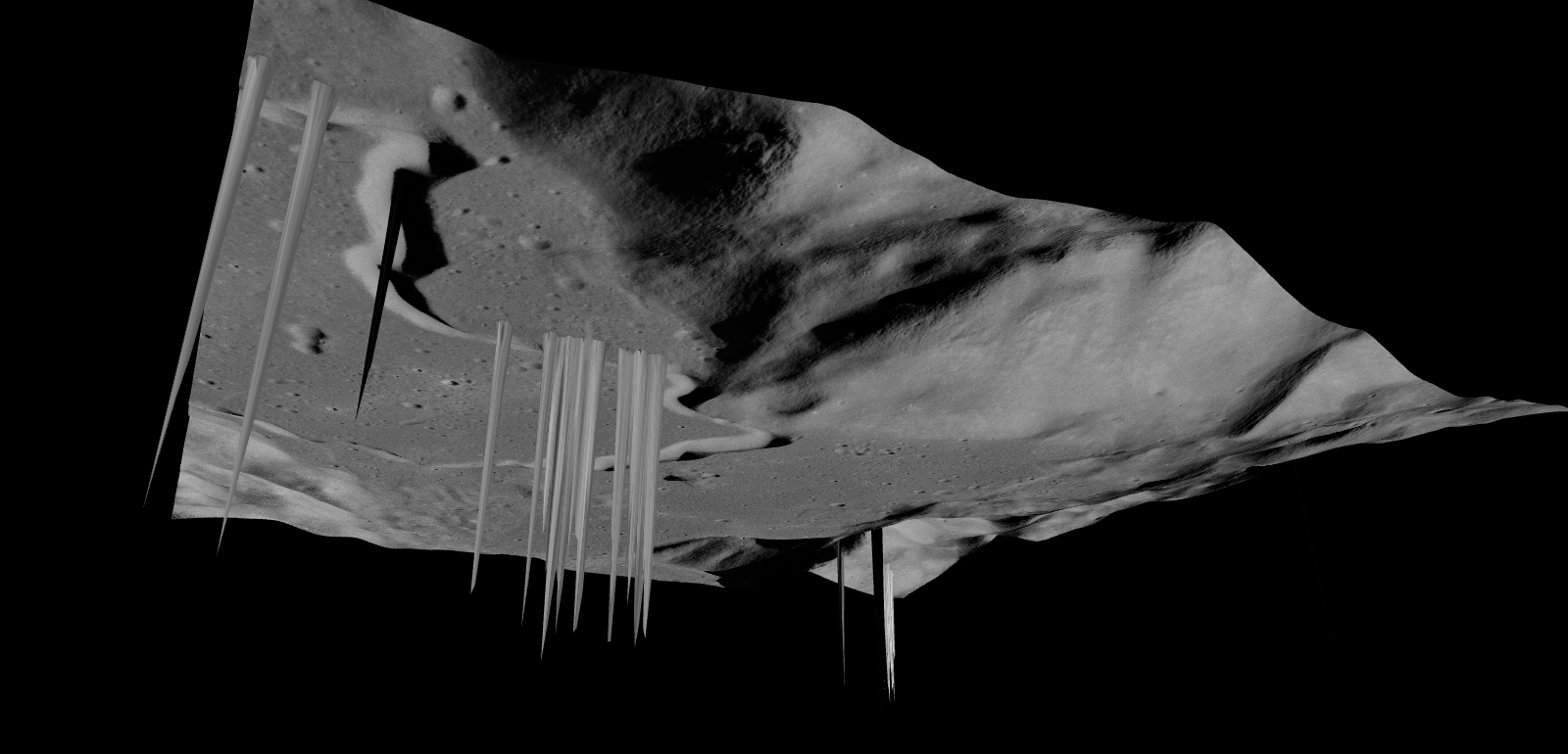
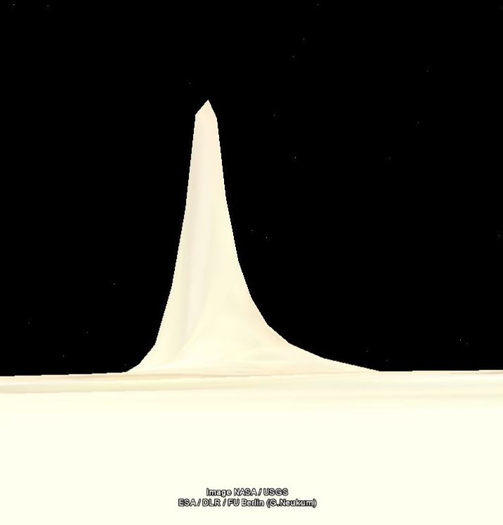
If you enter these coordinates to Google Earth while in the moon mode, the anomalies will be visible. You will see something that looks like "towers", possibly "several miles high". These are not image artifacts. Google Earth software renders the "towers" in 3D mode, but when you zoom out they will disappear. These anomalies are not visible in any LRO images.

I would like to hear your opinions on how to debunk a claim like this. It is easy to say these are software issues, but how to make sure? We know the Google Moon data sources: https://www.google.com/moon/about.html - in this case the data could originate from the USGS. USGS have stated that the data may contain errors. Google have also stated that the maps might not be accurate.

Perhaps the easiest way is to ask from Google and hope they answer? Or just use a good telescope and check the area.

Thank you!

Twitter & FB: @HoaxEye
 
Thanks! I used Google Earth in moon mode (View->Explore->Moon). Copy paste one of the coordinates to the search window. Double-click the result in the history window. I have also selected Global Maps -> Lunar Orbiter Mosaic.

You might have to zoom out/pan a bit before the "tower" becomes visible

Just in case, here is a screen shot
 
Last edited:
Google Moon is very low resolution. Inspect the areas using the Lunar Reconnaissance Orbiter (LRO) imagery instead. That has images with a resolution down to 1 metre or 50cm per pixel in many areas.

The LRO Quickmap is here: http://target.lroc.asu.edu/q3/

You have to enter the co-ordinates as decimal degrees rather than DMS format. The first location you give comes out as 22.36408056, 81.98694444.

That unfortunately corresponds to an area where high-res imagery is missing, but I don't see any towers:

upload_2017-4-5_14-1-46.png


Direct link: http://bit.ly/2p0sWJ8
 
Last edited:
Thanks! I know the towers are not there, but I'm unable to pinpoint the error. I have also checked several maps based on Lunar Orbiter Laser Altimeter (LOLA) elevation data, but they usually cover large areas. I will try to ask from Google.
 
This is the video you mentioned. I don't have Google Earth on this machine but they certainly look like glitches in the altitude data, if indeed they are genuinely on Google Earth (Secureteam10 is known for hoax videos).


Source: https://www.youtube.com/watch?v=PY7Xarpo75M


eg 0:45

upload_2017-4-5_14-4-43.png

Thank you. I'm painfully aware of Secureteam 10's hoaxes (this is why I didn't link the video). But these "towers" are on Google Earth. This is why I would like to debunk this tower claim properly.
 
this is why I didn't link the video

Just in case, here is a screen shot
how did you get your camera at such a low altitude? I also cant figure out how the video shots were taken... maybe I have an old Earth version? best I can get is:
m8.JPG

m4.JPG

looks like something funky happening with their 3d mode as none of the other features around seem to be in mega-3d like that. wonder if it has something to do with specific shadow placement.. like when artists draw 3d photos, theres a certain way to do it

hh.JPG


this is why I didn't link the video
Unfortunately you have to, unless you accurately present all their evidence (esp screenshots)and how they got it. For example I still cant figure out what settings he hit to make his hills look so pointy as I cant get mine pointy that much.
 

Attachments

  • m8.JPG
    m8.JPG
    67.1 KB · Views: 598
zoomed out the "towers" are obviously not as high as the blobs around it. so yea I think the shadows are messing with the 3-d programming somehow. my guess anyway

upload_2017-4-5_10-19-56.png

3d.JPG

upload_2017-4-5_10-26-41.png


add:
3D Images like those in Google Earth are generated through a process called texture mapping. Texture mapping is a technology developed by Ed Catmull in the 1970’s. In 3D modeling, a texture map is a flat image that gets applied to the surface of a 3D model, like a label on a can or a bottle of soda.” – Clement Valla @ rhizome.org http://twistedsifter.com/2013/04/when-google-earth-goes-awry-clement-valla/
Content from External Source
 
Last edited:
zoomed out the "towers" are obviously not as high as the blobs around it. so yea I think the shadows are messing with the 3-d programming somehow. my guess anyway

upload_2017-4-5_10-19-56.png

3d.JPG

upload_2017-4-5_10-26-41.png

Thank you, very interesting comment! Faulty 3D rendering of the shadows could actually explain this. I hope Google's moon team will reply.

But I didn't answer your first questions:
- Video:
Source: https://www.youtube.com/watch?v=PY7Xarpo75M
(they will not explain how to reproduce the effect). The video contains all kinds of other claims like NASA airbrushing the "towers" from LRO images, but I ignored those.

- How I made the screen shot: zoomed back, eye altitude about 8 km. Tilt down (shitft + arrow down), eye altitude about 2 km. I'm using the latest version of the client.
 
I don't think it's the shadows per se that cause the effect, it is just faulty elevation data. Google Earth (and Moon) makes its 3D images by draping the imagery of the surface over a digital terrain model, which is created from an elevation dataset independent of the surface imagery.


The elevation dataset for the moon is likely derived from the LOLA laser altimetry data. That uses laser light bounced off the surface to measure the distance. Rogue reflections or data dropouts would lead to individual data points with incorrect elevations, which the digital model would show as deep holes or tall towers.
 
I did it!!!
p2.JPG
22°21'50.69"N, 81°59'12.92"E

Now that I know how to tilt (thanks Hoaxeye).. and I changed the elevation exaggeration to 3 from the default of 1.
scale.JPG

I'm afraid to play with other settings. Why would they let you exaggerate elevations? I don't get it.

and you can see the texture on the pointy icecube is 'stretched'
upload_2017-4-5_12-43-27.png
 

Attachments

  • point.JPG
    point.JPG
    57 KB · Views: 591
Last edited:
It's useful on Google Earth to highlight up and downhill portions of a walk, for instance. And it just makes the terrain pop out a bit more.
ah.

ok here it is at 3 and the second pic I touched nothing but changed the exaggeration back to 1.

3.JPG


upload_2017-4-5_12-47-17.png

I don't know how to measure it's height.
 
Thanks for the great observations and comments! I checked the Mars "tower" discussion and found this: https://www.gearthblog.com/blog/archives/2007/05/giant_building_found.html - there was a 72 km "building" on Earth in 2007 which was later removed :)

About @Trailblazer comment about the elevation data: this could explain all "towers" and "holes". However, USGS have used both LROC NAC (Lunar Reconnaissance Orbiter Narrow Angle Camera) and LOLA (Lunar Orbiter Laser Altimeter) data to create DEMs (Digital Elevation Models). See page 11 https://astropedia.astrogeology.usg..._VV_Report_NLSI_LUNAR_SOUTH_POLE_20130412.pdf - "There are 20,349 points that have a difference larger than ±50 m and 234,793 points that have a difference of larger than ±25 m". These data points - if Google Earth uses them - could also explain these errors.

@deirdre : thanks for your trials with the "exaggeration" setting. I didn't know it affects the moon rendering.

I wrote an email to Google's moon team hoping they can provide some answers.
Given the age of google moon, and given that they simply say the elevation data comes from the USGS, are we sure it's not from the older Clementine data?
https://webgis.wr.usgs.gov/pigwad/down/moon_dl.htm
Might be worth checking to see if any glitches came from the Clementine data. The problem is that in the past I've found glitches with Google moon that are not present in the original data Google pulled from. It's not a primary source of any of this data, it's just using pre-existing data from other sources such as USGS. If the problem can't be found in the USGS data then it ends up being just another example of why it shouldn't be used as if it were primary source material, which is what hoaxers like Secureteam always do.

Here's the raw data for Clementine's LIDAR data:
http://pds-geosciences.wustl.edu/missions/clementine/lidar.html
 
Thank you @Astro
We don't know if the elevation data comes from the Clementine data. I couldn't find any detailed information from Google, NASA or USGS.

It would be interesting to analyse the LIDAR data, but I don't know how to do that. This requires more digging and learning...

I have not received any response from Google yet.
 

1. What am I looking at?

We've included four different types of data in Google Moon:

  • Visible - A mosaic of images taken by the Clementine mission. This is a black-and-white version of what you would see if you were in orbit around the moon. This composite imagery was prepared by the USGS.
  • Elevation - A lunar terrain map generated by the USGS in conjunction with the The Unified Lunar Control Network 2005, and shaded using an airbrushed shaded relief map. This map is color-coded by altitude, so you can use the color key at the lower left to estimate elevations.
.....
4. Where did all this data come from?

The data used to create the Visible and Elevation layers, as well as some of the high-resolution maps used in the Apollo layers, are courtesy of the U.S. Geological Survey.

Much of the rest of the material for the Apollo layer is derived from NASA's Apollo Lunar Surface Journal.

The USGS Geologic Atlas of the Moon, the Lunar Chart (LAC) Series, and some Apollo imagery are provided by the Lunar and Planetary Institute, managed by USRA.

https://www.google.com/moon/about.html#what
Content from External Source


The Elevation map layer was produced by combining a color elevation map derived from the ULCN 2005 data with an Airbrushed Shaded Relief Map which was warped by the USGS to align to the ULCN. The shaded relief map is not photographic image data, but rather was produced by professional map artists by hand from a large amount of source imagery. You may recognize this as the map from the first version of Google Moon, where it appeared in its original black and white
https://ti.arc.nasa.gov/tech/asr/intelligent-robotics/planetary/moon/#basemaps
Content from External Source


The digitized relief base was revised based on the Clementine mosaic and recent Earth-based radar imagery to show features in this area. Errors that were present in the original interpretations of lunar morphology have not been corrected in the digital version of the warped shaded relief map base. These original errors were caused by scanty data, ambiguities introduced by highly oblique solar incidence angles, and distortions created in generating orthophotographs from oblique images

https://webgis.wr.usgs.gov/pigwad/down/moon_airbrushed_shadedrelief_warp.htm
Content from External Source
 
Last edited:
Thank you again @deirdre - the elevation data source is mentioned, but I don't know much about topography. The language used in various webpages and documents is difficult to understand (at least for me).

If I understood the text correctly, Google Moon elevation data is based on Clementine images and other photographs:

This report documents a new general unified lunar control network and lunar topographic model based on a combination of Clementine images and a previous network derived from Earth-based & Apollo photographs, and Mariner 10, & Galileo images. https://pubs.usgs.gov/of/2006/1367/
Content from External Source
If true, more recent data sources like Lunar Orbiter Laser Altimeter (LOLA) is not used.
 
For what it's worth, Secureteam 10 seems to have had its YouTube monetisation withdrawn, due to numerous complaints about fake videos.


Strong language warning:

http://www.theangryufologist.us/bye-bye-secureteam-go-fk/


He makes in the ballpark of $300,000.00 to $500,000.00 a year by just publishing UFO hoax videos. Youtube just derailed his gravy train forever. If he is all about the truth let’s see how long he keeps up his Youtube channel now that it makes zero revenue.

A firm message was sent… Frauds will not be tolerated anymore. I love this. I have waited a very long time for this groundswell in support of truth and rationality.

I see around the web that people are whining that this is censorship. That this is the forces of evil trying to subjugate the truth by stepping on and silencing the little guy.

It has NOTHING to do with that at all. Google’s new initiative is driven by a desire to clean it’s search results of fake news and hoax sites. To make it a more valuable source of information. It is a reality that many, many websites and channels are blatant, patently, and expertly spreading fraudulent clickbait nonsense. This is not just an inconvenience but has real effects in the real world. Just look at the last federal election in the United States. This election and all the insanity that took place may be the impetus that made Google get off its hands on this one. Enough was enough a long time ago.

Mr. Glockner is not going silent into the night. He has launched a Patreon account to make up for his loss of income by Youtube deeming him a constant source of fake news. So after years of cashing in on people’s gullibility to be enthralled by flashy videos. Now he want’s you to compensate him directly to lie to you. It would be funny if it was not so pathetic.
Content from External Source
 
I hope YouTube will not change their decision concerning channels like Secureteam 10. They don't respond to any critic (except by blocking the offending accounts) or e.g. remove any videos that have been debunked.

However, I didn't start this thread because the claims were made by ST10. I don't think they even found these anomalies themselves. I wanted to debunk these Google Earth/Moon anomalies properly, but it seems challenging. I don't have the technical know-how to check the Clementine data as suggested by @Astro and Google has not replied via email or Twitter. It is easy to say these anomalies are caused by a sw bug, error in data or combination of both, but I would like to see some proof.
 
I enjoy digging into old raw data, but unfortunately I've got a lot on my plate right now myself. I'm currently working with a local university to get some telescope tracking software up and running on a variety of telescopes, which is a pretty time consuming process or else I'd take a crack at it. It's possible that Google's process of porting the data to Google moon created the anomaly, but I'd like to look at the elevation data in greater detail to try and track down the source of the error.
 
quick search.. heres the footage (2 min vid) from sept 2015 so yea Secure Team 10 didn't find it.

Published on Sep 5, 2015
All tower about 2-5 kilometers high
upload_2017-4-11_15-8-24.png
Content from External Source
I knew it! Thanks for providing the evidence. UFO hoax channels/websites rarely find anything by themselves. They spend the time making videos or blog posts (==money).
 
I enjoy digging into old raw data, but unfortunately I've got a lot on my plate right now myself. I'm currently working with a local university to get some telescope tracking software up and running on a variety of telescopes, which is a pretty time consuming process or else I'd take a crack at it. It's possible that Google's process of porting the data to Google moon created the anomaly, but I'd like to look at the elevation data in greater detail to try and track down the source of the error.
Sounds like an interesting project! No worries. I think this can be solved via e-mail to correct person(s). @deirdre sent me a list of potential contacts. I have some e-mailing to do :)
 
I think the simplest debunk of this for people would be to point out the fact that you can't see their shadows on the Moon.

For a start they are evenly lit in Google Earth - so much so that it's hard to see them from above. Even nearby very low terrain features have shadows:
See the one at 16°10'58.84"N, 87°34'54.84"E
20170412-093214-c16sy.jpg

Then look at the apparent size.
20170412-093449-4uxs6.jpg

6km wide and 5 km high. At lunar sunset when the terminator reaches the glitch it would make a long shadow. Shadows are quite stark on the moon doe to the lack of atmosphere.
20170412-103023-4jnkg.jpg

These shadows should be visible to anyone with a good pair of binoculars, or a P900.

20170412-103230-hydmi.jpg

Since we don't see them, they are not there.

This Glitch is on the near side at 20.856903°, -26.173004°, Northwest of Copernicus, and between Euler and Pytheas:

20170412-111112-yr8qs.jpg

20170412-100635-5tuc0.jpg

There's some nearby HD images in GE, showing just how stark the shadows would be
 
Last edited:
The terminator will be near that area on May 6, 05:00 UTC, and it will look something like this:

20170412-110350-3i0ll.jpg

20170412-110553-tfq1w.jpg


But a 6km tall & wide tower would cast a 100km long shadow that should be visible on a P900 image, even without cropping it would look like this:

20170412-122328-dharp.jpg

And not only shadows, a 6km high peak like that would also be visible past the terminator in the shadow as a very bright point of light, as in the thread: Explained: Moon Terminator/Shadow UFOs

And given that these glitches are all over the moon, if they were real then you'd be able to see them about every day somewhere on the terminator.

Moon terminator images from:
https://svs.gsfc.nasa.gov/4537
 
Last edited:
Excellent work by @Mick West - as usual :)

One possible next step: photograph the moon on May 6. I have a telescope, but no suitable DSLR connector. Also, spring time is often challenging for moon photography in Western Finland. Anyone else willing to give it a try?
 
Last edited:
I think there's probably sufficient photos already. I took one myself. Oct 11 2016
6:27PM, at a suitable phase to show the shadow if there was one:


Shadows in nearby craters, no shadow here.
20170413-084701-pz37c.jpg

Same day, 4 hours later:
20170413-085122-n7jp4.jpg
 
Last edited:
quick search.. heres the footage (2 min vid) from sept 2015 so yea Secure Team 10 didn't find it.

Published on Sep 5, 2015
All tower about 2-5 kilometers high
upload_2017-4-11_15-8-24.png
Content from External Source
After reviewing both videos again, it is clear that Secureteam 10 actually copied the footage from the Sept 2015 video. They never even mention the source. That is content theft.

Also: I have not received any responses from Google or NASA yet.
 
Lunar surface models are riddled with all sorts of data glitches. I've been having fun recently using QGIS to make 3D models of the surface using data from a variety of sources. This view of Hadley Rille is based on Japan's data and I've rotated the view see it from underneath.

 
Back
Top