Where and How could the Wallace Experiment Easily Be Repeated?

I can't quite tell from the crop, are those wires at the gas station (or at least close by)? That's pretty incredible to be able to pick out individual utility cables from 5km away.

They are about 300m closer to the camera, but you can also see power lines behind it at the top here: (8:22AM pic)
20160928-103140-x5z4f.jpg
That red sign is also behind the gas staton, it's about three feet high
 
Last edited:
At 11:10AM, temp around 83F in the shade, hot sun warming the ground.
20160928-111531-ol6ab.jpg

So I think we can conclude there's a "sweet spot" in the morning during warm sunny weather. Maybe the first hour after the sun hits the ground.

I can't quite figure it out though why is there so much turbulence at 6:18AM?
20160928-112124-hfjk9.jpg

I'm guessing it's because the ground is warmer than the air from the previous night. So the sweet spot occurs when the air temp matches the ground temp. Then the top of the ground gets hotter faster than the air.

Maybe related to the angle of the sun, and the rate at which air is warmed by the sun passing through it (not a lot, I'd think) and the rate at which the ground is warmed.
 
I'm quite flabbergasted by how good that one time turned out to be. This one is from 2:30:
20160928-172543-vdvc4.jpg

It almost looks like it's out of focus. Maybe the camera can't really focus. Looking at a video from the same like it's an incredibly fast shimmering. It should try higher shutter speed. This was 1/500
 
Well things have settled down a bit, but now there's a problem with haze.
20160928-174231-jyngj.jpg

That's at 1/2500th, but it's a mixed bag over slower speed. The sweet shot was on Auto, and came out as ISO 140, f/6.5, 1/500th. I also shot it in burst mode, but all the shots in the burst seemed fine.

So I'd say, for Wallace, if done on a hot day, then do it shortly after the sun rises enough to be normal color.
 
I'm guessing it's because the ground is warmer than the air from the previous night
is your elevation vastly different from the gas station? maybe besides the ground/air evening out, the air between you and the gas station has to even out too? (i'm totally making this up.. not sure if it's an actual thing).
 
is your elevation vastly different from the gas station? maybe besides the ground/air evening out, the air between you and the gas station has to even out too? (i'm totally making this up.. not sure if it's an actual thing).

No, we are pretty much at the same altitude.
 
Stack of 14 of the good images, 2x res, and average. Auto tone
20160928-181119-9trut.jpg
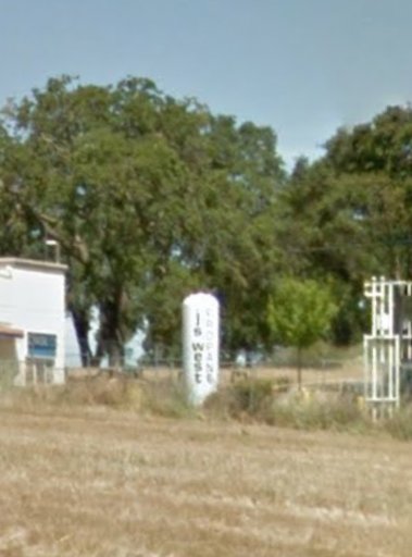
Amazingly the vertical white sign ("js west PROPANE") is almost as legible from that distance as it is from the Street View car on the freeway right next to it!

IMG_7453.jpg

You can make out the individual letters on the green "FREEWAY ENTRANCE" sign at the bottom, too, but it's not legible unless you know what it says.
 
Three places that spring to my mind are...

The Wash (Gibralter Point to Hunstanton head)
wash.jpg
The Solway Firth (Silloth to Southerness)
solway.jpg
Morecambe Bay (Rampside to Morecambe)morc bay.jpg

All three are areas of level mud flats that with calm waters with predictable tides and all are between 9 - 12 miles across
 
All three are areas of level mud flats that with calm waters with predictable tides and all are between 9 - 12 miles across

The Wallace experiment really needs some solid ground in the middle - to avoid boat problems. A mud flat with the tide out might be interesting though.

Also 9 miles is far too much for this type of experiment. We'd be measuring the "bulge" between two points, and at 9 miles that's 13.5 feet.

Wallace did it at six miles (with a center target at 3), giving a target difference of 6 feet.

I think actually it might be possible to use a span as narrow as four miles, which gives an offset of 2.5 feet, probably not much less than that though.
Plenty of buoyage in The Wash. It should be possible to find out the dimensions. https://www.trinityhouse.co.uk/mariners-information/navigation-buoys/cardinal-marksWash chart1.jpg
 
Last edited:
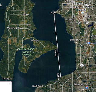
In the Seattle area, there is a long candidate of 7.98 miles. The two endpoints are Three Tree Point to the north and a spot 1/4 mile west of the 20th Place SW Road End beach access in Federal Way to the south (unclear if the spot we need is accessible to the public, or a private beach NEAR a publicly accessible beach). The land in the middle is Point Robinson Park on Vashon Island, 4.27 miles south of Three Tree Point and 3.61 miles north of the Federal Way location.
 
Maybe someone could persuade the UK's Canal and River Trust to set up some permanent markers on the Old Bedford River as a memorial / tourist attraction.

And there must be some other long straight canals in UK, and elsewhere in the world (Holland?)
 
The Sacramento ship canal is about 50 miles from me. 20161002-112435-adfej.jpg

There's also some irrigation canals down in the Delta. Like the Grant Line Canal, nearly eight miles straight, or five from the west end to the bridge. Lacks corresponding bridges though.

20161002-113606-w8kl9.jpg
 
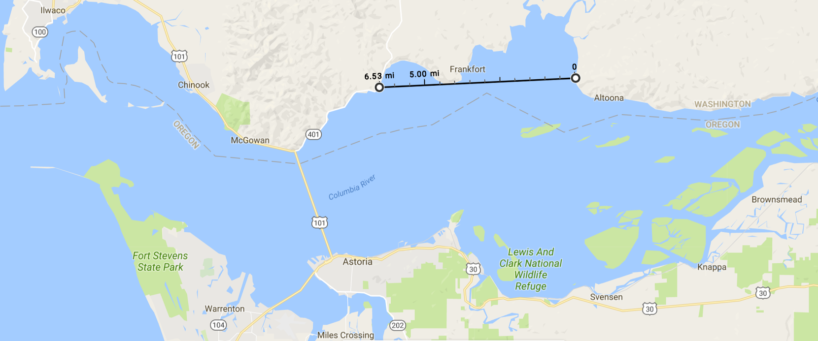
Near the mouth of the Columbia River, there are three spots in Washington that might work. The ends are 6.5 miles apart, the 'mid' location at Grays Point is 4.2 miles from the east end near Altoona, WA and 2.3 miles from the west end near Knappton, WA.
 
This seems like an ideal school science project!

Indeed, I keep suggesting it to my teacher friends.

It would be great to identify some workable locations - both for the fun and educational side of things, and for the flat earthers.
 
Revisiting this after my Los Angeles trip, here's a crop of a digitally zoomed video shot at about six miles - the actual distance of the original Wallace experiment. It's the area around the entrance of the Getty Villa, viewed from Venice Beach.

20170201-074257-wcoye.jpg

You can easily resolve features just a few inches wide, like the middle vertical white bar in the windows. Here's the street view of that building:
20170201-075028-x591b.jpg


So I think that shooting video of the experiment would work very well with a tripod mounted P900. You could zoom in on the distant target, demonstrate it's below the middle target, and then zoom all the way back to demonstrate the position of the camera, like here with the Getty Villa zoom.

Source: https://www.youtube.com/watch?v=Mu_JjQ52J0E
 
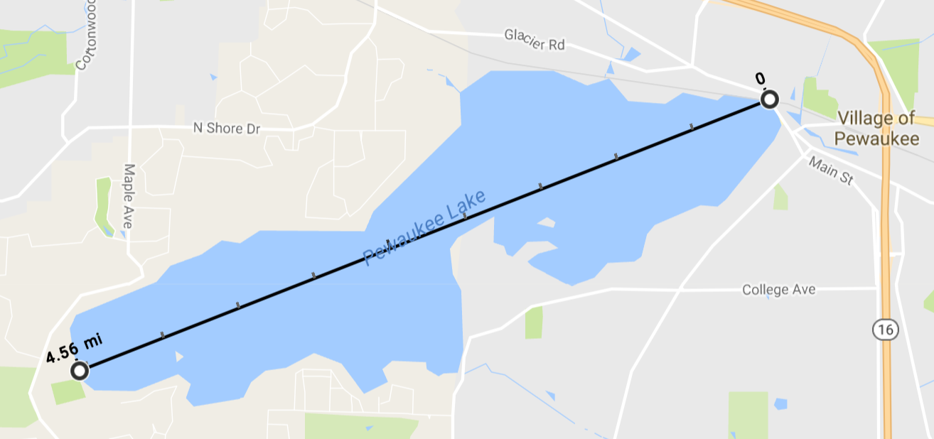
Pewaukee Lake in Wisconsin offers what appear to be easy access points at the two ends of a slightly undersized version of the Wallace experiment.


At the west end is the public boat launch, where you can walk right down the ramp to the water. This also gives one the opportunity to take sightings from several different elevations. At the east end is a park where it should be possible to walk to the water's edge again. If conducting observations at night, it might be possible to spot the east endpoint from the boat launch by watching for the flashing railroad crossing guard arms. The road is above the water line (of course) and the arms should begin flashing while still in the elevated position.
 
I'm toying with doing a series of experiments that are tailored to be compelling to the FE community. One of the things I want to do is simplify the ubiquitous 'does the horizon hide the right heights of buildings' experiment.

Typically this experiment is done with architecture viewed from fairly long distance. I wanted to try to set up something on a much smaller scale. Using measuring sticks that I plant into the ground at 3, 3.5, 4, 4.5 and 5 miles. I also wanted to avoid viewing over water. By viewing over short distances and doing it over dry land, I can eliminate two major contributors to refraction. It will also allow me to get temperature and air pressure readings all along the line of sight so that I can at least know what AR is there.

The thing that seems a little tricky is finding a suitable spot. Here's my question:

I live in Los Angeles and the beaches here are easy to access and fairly straight and open. I don't think it would be hard at all for me to find a 5 mile stretch right along the water's edge. What I am wondering is: if I draw an imaginary line right at the tide-line along the beach for five miles. Are all the points on that line guaranteed to be at, with some minor error rate, the same elevation?

I think they are. And then I think that means I can count on that line following the general curve of the globe.

Does that sound right?
 
Last edited by a moderator:
I live in Los Angeles and the beaches here are easy to access and fairly straight and open. I don't think it would be hard at all for me to find a 5 mile stretch right along the water's edge. What I am wondering is: if I draw an imaginary line right at the tide-line along the beach for five miles. Are all the points on that line guaranteed to be at, with some minor error rate, the same elevation?

I think they are. And then I think that means I can count on that line following the general curve of the globe.

Does that sound right?

(I moved this post to this thread, as it's essentially a Wallace experiment).

I don't think you can use the tide-line with enough accuracy. Waves can vary quite a bit, and can push the height of that line by up to a foot. Not only will waves vary randomly, they also vary with topology. So the high water place in one point on a beach might be very different to another a few miles away where the waves tend to be higher.

This is why lakes or canals are preferred.
 
(I moved this post to this thread, as it's essentially a Wallace experiment).This is why lakes or canals are preferred.

Okay, that makes sense. So, assuming a still body of water like that. The surface of the water will curve so that the tangent to any point on the water is perpendicular to the gravity vector - is that right? And if I know my elevation above sea-level for one point at the water line, I know it for all points?

I can't imagine why that wouldn't be the case but i ask just as a first pass at trying to make sure there's no weird phenomena I need to know about.

I'm trying to design irrefutable experiments - which is probably just a neon sign to my naiveté - but without changing the laws of physics (which I know is fair game for some) is there any conceivable cause of curvature between two points on a water line other than curvature caused by gravity?
 
Okay, that makes sense. So, assuming a still body of water like that. The surface of the water will curve so that the tangent to any point on the water is perpendicular to the gravity vector - is that right? And if I know my elevation above sea-level for one point at the water line, I know it for all points?
Correct.

I'm trying to design irrefutable experiments - which is probably just a neon sign to my naiveté - but without changing the laws of physics (which I know is fair game for some) is there any conceivable cause of curvature between two points on a water line other than curvature caused by gravity?
Not in any practical sense, no.
 
I thought the reason people don't measure over land is because of possible hills and whatnot.

He's basically talking about three points on the shore or side of a body of water. This is the Wallace experiment. You fix three targets at a fixed height, and see if the middle one is above the other two (it is).

You just need those three points. Typically this would be across a body water but it could also be along a canal, or along the shore, like along a long straight beach.
 
I got a good one:

Snowmass Mountain in Colorado is 14,099 feet high. About 82.5 miles to the northeast is the 14,200 feet high Mount Evans. And directly in line between the two, about 55.5 miles from Snowmass is 13,800 feet high Crystal Peak.

If the earth is flat, Mount Evans will be visible beyond Crystal Peak. If it's not, we won't see Mount Evans at all.

Not strictly Wallace - but a similar principal.

They probably assumed the earth was a spheroid when they measured the heights of mountains so it is rather a spherical argument.
 
That, of course, is the out - that the elevations aren't what they say they are. ;)
Though getting all the elevations in a mountain range to tally up to a flat earth would be a pretty impressive feat.

Anyway...

Just had an idea about where to repeat the Wallace experiment: how about at Bedford Levels? ;)

I've just arrived back in England and since I'm a free agent I'd be very up for going there and doing it. We could design the experiment together. Maybe get some prominent flat earthers along too.

Initial sketch: a pole or 2x4 about halfway along, painted in stripes maybe 10cm thick (and perhaps in different colours) topping out at least six feet above the water (and perhaps with something on top, like a ball); a large target - big bed sheet stretched over a wooden frame, for example - similarly marked to identify measurements; and perhaps a platform across the canal at the viewing end, where various stable camera heights could be achieved.

That's just off the top of my head; something like that. Perhaps even with identical poles a quarter and three-quarters of the way there.

Questions:

1. How powerful will the camera have to be? Will a P900 do it over that distance?
2. Who's interested in coming along?
3. What impact might the addition of the railway bridge have?
4. Is there perhaps a better canal, with (3) in mind? (Next longest straight stretch I can find is 3.5 miles, in the River Ancholme, west of Brigg.)

Cheers. :)
 
Last edited:
Here's a location on the potomac river in Northern VA. 5.7 mi across, with the peninsula in the middle.
upload_2017-5-30_16-9-21.png
 

Attachments

  • wallace exp.tiff
    1.5 MB · Views: 970
I've just arrived back in England and since I'm a free agent I'd be very up for going there and doing it. We could design the experiment together. Maybe get some prominent flat earthers along too.

I think the first step would be to visit it on a clear day, and take some photos from each end at various zoom magnifications. That way any problems would become apparent. Placing targets would be a phase 2.
 
The next time I'm in Antarctica I could possibly set up the a Bedford level-type experiment on sea ice. The sea ice in McMurdo sounds typically extends for over 30km from shore and a close to uniform thickness and conforming to the surface of the sea. If some targets were set on the hard ice surface (areas without snow on top, as this might displace the level of the ice) they should all be the same height above the sea surface.

There is often a pretty strong refraction (Fata Morgana) observed over the sea ice, so I'm not sure how far apart the targets would need to be nor how high above the ice surface they would have to be to get a true result. I guess it could be done several times with temperatures recorded to increase accuracy.

Of course I've already seen the shore and lower part of Ross Island disappear as I've driven away from shore, but I've never thought to document it, it should be an interesting experiment. Any suggestions for the distances or target heights would be appreciated.
 
How would you prove that the ice was level? Or, indeed, that the places you set the targets were level with one another?

Flat earthers believe "water finds its own level" - not sure that necessarily follows for ice. ;)
 
How would you prove that the ice was level? Or, indeed, that the places you set the targets were level with one another?

Flat earthers believe "water finds its own level" - not sure that necessarily follows for ice. ;)

That's actually a good question Rory. Sea ice is floating on the sea, it always has 10% of it's thickness above the surface of the sea. A part of my job down there is regular measurements of the ice thickness. It's generally a fairly uniform thickness early in the season and doesn't really change across large distances until it starts to break up in late summer. Effectively the surface of the sea ice (without snow cover) is parallel to the sea surface, so it works well as a level (not flat) surface for looking at curvature over the earth.
 
That's actually a good question Rory. Sea ice is floating on the sea, it always has 10% of it's thickness above the surface of the sea. A part of my job down there is regular measurements of the ice thickness. It's generally a fairly uniform thickness early in the season and doesn't really change across large distances until it starts to break up in late summer. Effectively the surface of the sea ice (without snow cover) is parallel to the sea surface, so it works well as a level (not flat) surface for looking at curvature over the earth.
The main problem I can see is that because you work for 'them' (the NWO / big science / NASA / insert nefarious organisation here) and many FE types hold firm to the notion that 'they' don't allow 'normal people' there (complete cattle droppings of course) any results you come up with will be dismissed as false and concocted to maintain the 'lie'.

Although having said that I think its a spiffing notion and an interesting experiment to carry out.
 
Sea ice is floating on the sea, it always has 10% of its thickness above the surface of the sea.
So if one section of ice is 1 metre thick, and another section 2 metres thick, does that mean the surface of the latter section is 10cm 'higher' than the first?
 
Back
Top