What is this? A rocket over a civilian airport?

Jimmyd

New Member
I dont want to speculate, and I am familiar with how contrails at angles can appear to be coming from directions they are not but this was truly something else...or an epic mind bender. This seems to be perpendicular to the earths surface, and the trajectory is straight UP. I have thought about how this may be a commercial flight pattern, but cant make sense of that theory given the angle and trajectory.

Thoughts please?

Observed close to the Highpoint NC airport yesterday AM around sunrise.

20161011_070608.jpg
 
Last edited:
I dont want to speculate, and I am familiar with how contrails at angles can appear to be coming from directions they are not but this was truly something else...or an epic mind bender. This seems to be perpendicular to the earths surface, and the trajectory is straight UP. I have thought about how this may be a commercial flight pattern, but cant make sense of that theory given the angle and trajectory.

Thoughts please?

Observed close to the Highpoint NC airport yesterday AM around sunrise.

20161011_070608.jpg

Just a plane flying directly toward you. Well... toward OVERHEAD of you.
 
I have thought about how this may be a commercial flight pattern, but cant make sense of that theory given the angle and trajectory.
If the aircraft is coming directly towards you (ie it will fly directly overhead) then its contrail will appear to be vertical from your position on the ground.

If it passes slightly to one side of you, it will appear slightly off vertical, as in this picture by @M Bornong (link here: https://www.metabunk.org/photos-of-...t-you-took-yourself.t1487/page-25#post-192004 )


And one I took (with a shorter contrail)


My location was roughly in the red circle:

upload_2016-10-12_18-0-10.png


Similarly, a plane flying directly away from you will appear to be going vertically downwards, like the one on the left here:

 
36.078292,-79.961608

7:04 am this tuesday morning. About 55 degrees northeast

What you say makes sense as looking at my position i am right downstream, almost exactly with a runway at piedemont triad airport.

Im still trying to wrap my brain around it :) if you think about the three dimensions what you makes sense, but what is seen by the eyes makes it hard to digest!!

I don't really see any good candidates for that time. Are you sure it's 7:04AM EDT? (11AM UTC) on Oct 11?
 
Last edited:
you saw the contrail forming or the contrail was there when you looked out the window?
It's hard to tell from the picture but I think the plane is still there at the "top" of the trail in the picture. You can't see the plane itself but the trail still looks new.
 
36.078292,-79.961608

7:04 am this tuesday morning. About 55 degrees northeast

What you say makes sense as looking at my position i am right downstream, almost exactly with a runway at piedemont triad airport.

I don't really see any good candidates for that time. Are you sure it's 7:04AM EDT? (11AM UTC) on Oct 11?

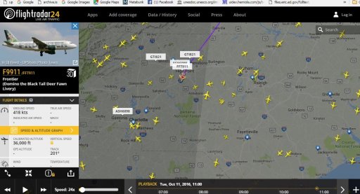
Perhaps, FR24 playback plays tricks on you, because I can see two candidate flights following the same track but are 2000 feet apart by the altitude. Shown on the left is the highest:
Screen Shot 2016-10-13 at 09.28.33.png
 
hmm i saw those too but they passed 'his' area for me around 6:45-50ish

I have downloaded the kml files of both tracks from Flightaware (attached) and looked at them in Google Earth from the given coordinates:
Screen Shot 2016-10-13 at 12.42.38.png
FFT901 is yellow and FFT101 is magenta. The top ends of each thick segment are the positions of the respective planes at 11:04 UTC. A westerly high altitude wind at the time would have deflected their trails to the right (east), therefore the trail may have look even more 'vertical' that the track. The red line is a hypothetical direction of the trail deviating from the yellow track by only about 5°.
 

Attachments

  • FlightAware_FFT911_KTTN_KTPA_20161011.kml
    14.3 KB · Views: 829
  • FlightAware_FFT101_KPHL_MMUN_20161011.kml
    34.7 KB · Views: 817
Last edited:
you saw the contrail forming or the contrail was there when you looked out the window?

Great question...this was already formed at 7:06 am EST. (Not 7:04, apologies), it was definitely the 11th. And the time is as accurate as cell phone time can be. I did not see it form
 
Last edited:
Wow..amazing work. So these are planes already in the air passing over the airport, right? Not planes taking off from that airport.
 
Wow..amazing work. So these are planes already in the air passing over the airport, right? Not planes taking off from that airport.
Correct. Planes don't usually leave contrails until they reach near cruising altitude, which is usually 75-100 miles from the airport, so you won't generally see contrails from them near to the take-off airport.
 
So whats the verdict on what flight this was?
One of the two, FFT911 or FFT101. Both flights followed essentially the same track at the same time. My educated guess, it more likely was the former. It was at 36000 ft where the predicted relative humidity was about right for long persistent contrails. The latter was 2000 ft below, where the air could have been dryer (and I have no data or prediction for this altitude), so it could make short or no contrail.

Edit:

Or it may be the other way around. I misremembered the relation between atmospheric pressure and altitude. In International Standard Atmosphere and Pressure Settings, 250 hPA corresponds to 34000 ft, that is, the altitude of FFT101 flight.
 
Last edited:
Here is a pictorial analogy I like to use, regarding perspective of contrails seemingly flying "straight up", or "vertical" like a rocket.......

Are the ceiling lights in this photo going vertically "up", or are they going horizontally "overhead" ?

coridor_lights_perspective.jpg
Source: Getty Images
 
Back
Top