Planefinder.net vs. Flightradar24.com vs. Flightaware for US traffic

Mick West

Administrator
Staff member
At least around Los Angeles, FlightRadar24.com only displays about 1 in 10 planes. Where Planefinder.net shows a lot more:


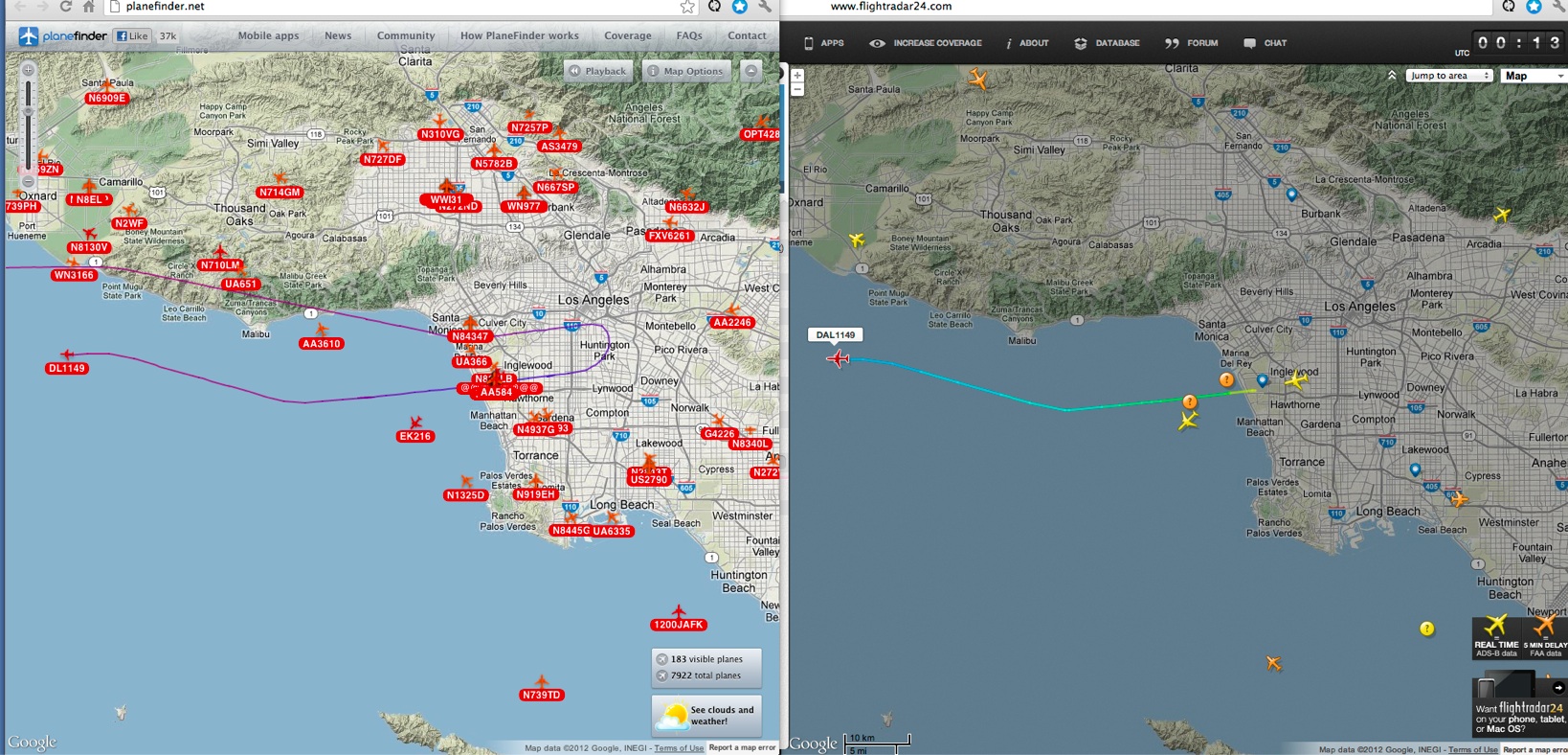
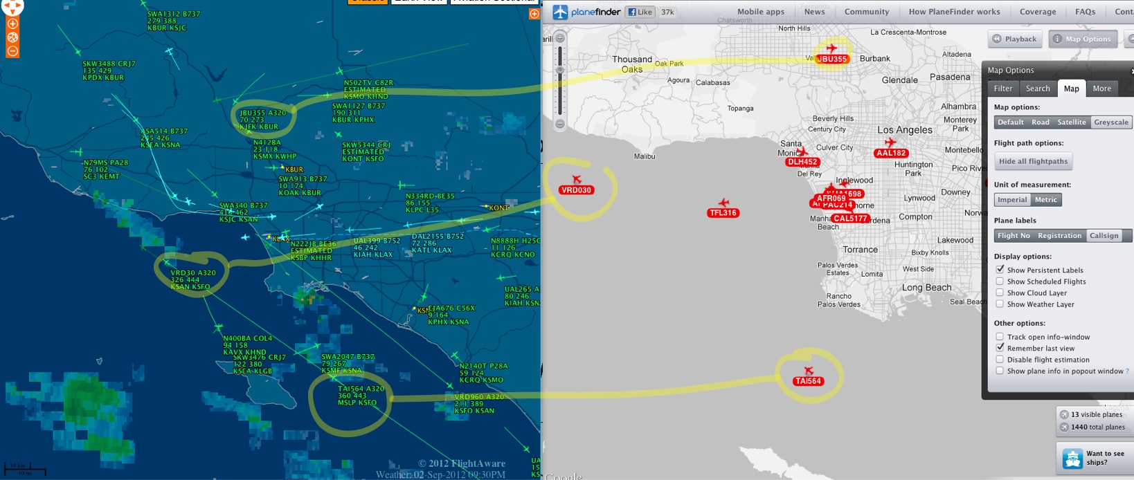
It's a bit surprising as Planefinder claims to work just of ADS-B, but FlightRadar24 says it is ADS-B plus FAA data.

This means there are a lot more planes using ADS-B than I thought, and flightradar24 just has a poor network in the US (it's much better in Europe).
 
Last edited:
neither of those two are very good at all. Flightaware is much better. Compare and see, especially on an older 'puter with limited connectivity.
 
What a con! I thought it was too good to be true. I figured out what it was doing - it's actually interpolating the position of scheduled flights. No wonder I could not match it up to anything I could see. It's basically guessing the position of 90% of the flights based on when they were supposed to take off and land, and using straight line reckoning. You can turn it off in the options, then you just get the same planes as flightradar24, but far less than FlightAware


I think we can safely say that anyone using EITHER planefinder or flightradar24 in the US is generally not going to find their planes.
 
Last edited:
As far as I understand from the Flightradar24, they depend much on volunteers who operate private ADB-S receivers.

I have recommended doing this to chemtrail believers; if they'd have their own receiver (starting at around 250$), there is nothing in between them and the plane trailing overhead.
 
I'm a little embarrassed to admit that I've tried, and I can't figure out how to use flightaware's website to track all flights currently over an area - only to look up specific flights. I don't have a smartphone, so I can't use their mobile apps. I click on various links that seem like they'll have something similar to planefinder or flightradar24's interfaces, but I never seem to find it.
 
Belfry,
On flightaware, just select an airport near to your location, go to full screen, and then zoom in or out wherever you want.
You can view data for individual planes by hovering over them, or place your cursor near the top of the page to view data for all planes.
This works well for my windows 7 computer. The data refreshes itself automatically. A decade ago I subscribed to a professional version of Flight Explorer which was exceptionally good. This version had no advertisements loading up and may use less bandwidth thus increasing your refresh capacity.

Mick is far more computer savvy than I and has better equipment, and I will say that my older XP machine had a hard time using flightaware, especially when confounded by a slower connection speed, so there may be many variables contributing to success in flight tracking.

Considering the utility of flight tracking in removing much of the mystery about identifying planes using the tool, it might be valuable to create a "Flight Tracking for Dummies" tutorial including a rating for various versions.

Any takers?
 
As far as I understand from the Flightradar24, they depend much on volunteers who operate private ADB-S receivers.

I have recommended doing this to chemtrail believers; if they'd have their own receiver (starting at around 250$), there is nothing in between them and the plane trailing overhead.

I was initially tempted, by looking at the extensive fake planefinder data, but then realized it would really be showing me very little more than what is online.

Still, one advantage is you could use it in a laptop without any need for internet, so it would be faster and more mobile. My wife would disagree about the $250 though :)
 
Belfry,
On flightaware, just select an airport near to your location, go to full screen, and then zoom in or out wherever you want.
You can view data for individual planes by hovering over them, or place your cursor near the top of the page to view data for all planes.
This works well for my windows 7 computer. The data refreshes itself automatically. A decade ago I subscribed to a professional version of Flight Explorer which was exceptionally good. This version had no advertisements loading up and may use less bandwidth thus increasing your refresh capacity.

Mick is far more computer savvy than I and has better equipment, and I will say that my older XP machine had a hard time using flightaware, especially when confounded by a slower connection speed, so there may be many variables contributing to success in flight tracking.

Considering the utility of flight tracking in removing much of the mystery about identifying planes using the tool, it might be valuable to create a "Flight Tracking for Dummies" tutorial including a rating for various versions.

Any takers?

I also subscribed to flightwise.com for a month once. This has "area tracking", where you can view the flights in a region in Google Earth in real time, this was somewhat useful. Basically the same data as FlightAware.

There are also several iPhone and iPad flight tracking apps. Flightwise has one called "Tracker" which can show you all the nearby planes. I have the "Pro" version. Then there's a FlightRadara24 iphone app - but again very limited by the ADS-B coverage.

Just noticed FlightAware has an App now, I'll check it out.
 
This is the FlightAware app running on an iPad, in the "Nearby Me" mode.


Would be more useful if I were not right next to LAX, as 90% of the traffic here is low level LAX traffic. There's another airport specific mode that kind of filters it by color like the web site, but it's kind of cluttered. Still, it's all free, so can't complain.
 
Last edited:
Interesting look at hurricane Sandy on FR24:


The blue markers are airports with delays or closures. And there are normally a LOT moe flights in that area. Most of the flights are yellow, meaning they are from Europe. Almost no local traffic.
 
Last edited:
Ian Carstairs over in Bedford, UK is having trouble identifying planes on planefinder. I am re-posting Mick's grid visualization in googleearth to show him the approxmate elevation of high altitde flights he might be seeing. His comment in in Pre-WWII Contrails at contrailscience.
Google_Earth-grid.jpg
 
I've been using these to try to anticipate planes arriving overhead today, specifically A380's as they are the biggest, and easiest to photograph. I've found planefinder.net much better than flightradar24, as PF seems to extrapolate the plane positions a lot better, meaning I could just pop out front when the plane was a minute away, and it would appear in the sky on schedule.

 
Last edited:
Although redundant for a lot of users from the US here, in Europe one can use Casperflights.com. The real live view is not for free;
you'll face a delay of 15 minutes at free use, but you can freely use the history. For me quite usefull to identify planes after noticing
contrails.
I particularly like its vivid interface with most planes recognizable by their company's style and its smooth aircraft-animation.
One can also select multple flights by pressing Ctrl-key.

For instance these condensed persistant contrails above the border region NL-DE eastward from Apeldoorn-Arnhem, caused by ascending
traffic from Schiphol/AMS at plm 29000 ft hight; pics token on a trip from Apeldoorn to a village called Dieren, facing southeast:

_IGP2784_1413_EZY726V_DLH2FCustom.jpg

_IGP2788_1432Custom.jpg

Or later:

_IGP2799_1459_THY7LR-KLM411-KLM427Custom.jpg

_IGP2800_1503Custom.jpg


Jan.
 
I've been using these to try to anticipate planes arriving overhead today, specifically A380's as they are the biggest, and easiest to photograph. I've found planefinder.net much better than flightradar24, as PF seems to extrapolate the plane positions a lot better, meaning I could just pop out front when the plane was a minute away, and it would appear in the sky on schedule.

Mick, love your pics. Got a few honest questions here and although we disagree in some parts, you have been straight with me. First, when contrails become visible and the atmosphere is right is there a specific altitude when they can exist and either below or above these points contrails do not appear? Is there is a "zone" that you are in or is there multiple layers? Second, could it be possible that atmospheric conditions have altered or changed, we know CO2 is rising, that could account for the increased trails? Could the fuel they are using changed or altered in some way, or jet engine designs have altered that could account for their increased amounts? When I look to air traffic, I see the numbers decline since the 2008 collapse and consolidation of the industry that doesn't account for the increased numbers over the past 2 years. Also, is there a specific style or aircraft that exhausts greater levels of contrails than others when there outputs are the same, say 2 equally size planes under the same load in the same sky, one producing larger plumes than another? What I would term as a richer running engine. And finally, what is your preferred software you use now, I grabbed flightware but had to upgrade as the flights disappeared as we zoomed in, free was frustrating.
 
Last edited by a moderator:
woody, the answers to all the questions you ask now have long been available at contrailscience.com. Study all the articles along the left hand margin, and if you don't find the specifics or want more details, ask again Mick has spent many many hours compiling his website, only to have it called "disinfo" by the (mis)leadership of the chemtrails community. The problem is that they will not engage in actual debate or point out specific things they disagree with.

I find it VERY odd that having been here so long, having already made conclusions about contrails and having all the answers to your questions so readily available, you find the need to ask them here when they have long been covered in depth at contrailscience.com.

It is almost like you ignored his work.
 
Mick, love your pics. Got a few honest questions here and although we disagree in some parts, you have been straight with me. First, when contrails become visible and the atmosphere is right is there a specific altitude when they can exist and either below or above these points contrails do not appear? Is there is a "zone" that you are in or is there multiple layers? Second, could it be possible that atmospheric conditions have altered or changed, we know CO2 is rising, that could account for the increased trails? Could the fuel they are using changed or altered in some way, or jet engine designs have altered that could account for their increased amounts? When I look to air traffic, I see the numbers decline since the 2008 collapse and consolidation of the industry that doesn't account for the increased numbers over the past 2 years. Also, is there a specific style or aircraft that exhausts greater levels of contrails than others when there outputs are the same, say 2 equally size planes under the same load in the same sky, one producing larger plumes than another? What I would term as a richer running engine. And finally, what is your preferred software you use now, I grabbed flightware but had to upgrade as the flights disappeared as we zoomed in, free was frustrating.


Briefly, contrail regions are like invisible clouds, so they form in the same shape as clouds do, sometimes scattered, sometimes in layers.

The atmosphere has not changed in a way that would make more contrails in any significance.

Fuel is the same, engines make a few more contrails with cooler exhaust.

You are just paying more attention, so you notice more traffic.

New vs. old engines are different.

planefinder.net

And like Jay says, these questions have been asked and answered many times before. Try just typing a simple version of the question into google, maybe adding site:contraiscience.com and see what comes up.

Example:
https://www.google.com/search?q=do+some+planes+leave+different+trails

goes straight to:
http://contrailscience.com/why-do-some-planes-leave-long-trails-but-others-dont/

And there's often other sites to back it up.

Sometimes it's helpful to add -chemtrails to exclude conspiracy sites.
 
Woody,

about the effect of rising CO2 levels (I don't think this was discussed on contrailscience):

Warmer air can hold more water (absolute humidity, not relative). Also, climate scientists are predicting more violent weather due to warming. Violent weather means increased convection (vertical movement and exchange).

I think it is a plausible assumption that this may affect the humidity level at contrail altitude, at least locally. Any thoughts from the weather professionals?

It's also possible that the "contrail zone" will be shifted upwards a little.
 
Hmm, solrey, that Tim Ball article seems a wee bit limited in perspective. Is his assessment accepted in the scientific community?

The polar/moderate difference was part of this research project:
http://www.theregister.co.uk/2013/0...al_warming_based_weather_affecting_mechanism/
(Same story, different publication:)
http://phys.org/news/2013-02-weather-extremes-provoked-giant-atmosphere.html

More confirming opinions:
http://www.sciencedaily.com/releases/2012/08/120820114041.htm

Anyway, I'm not convinced that this is just a matter of media hyping.

A useful wrap-up of possible (and observed) effects is here:
www.skepticalscience.com/extreme-weather-global-warming.htm
 
Is there a tracker that will let me me enter in my location and time to see what was passing over at the time?
 
Is there a tracker that will let me me enter in my location and time to see what was passing over at the time?
Flightradar24 has a "Playback" feature (in the toolbar on the upper-left) which will let you choose a time from the last 30 days and watch the data from there. You have to navigate to your location on the map and figure out the time in GMT. It lets you watch the playback at higher speed if desired, too.
 
Thanks, it's a bit annoying having to adjust for UTC time, but I think I got it figured more or less.
 
Is there a tracker that will let me me enter in my location and time to see what was passing over at the time?

Flightaware and Flight Explorer offer sale of recorded FAA flight track data going back over ten years. I don't know exactly how much they charge, but have considered doing this if a cemtrailer made a specific enough report which required such an effort.
 
Flightradar24 has a "Playback" feature (in the toolbar on the upper-left) which will let you choose a time from the last 30 days and watch the data from there. You have to navigate to your location on the map and figure out the time in GMT. It lets you watch the playback at higher speed if desired, too.

Anyone recommend which browser to run it in? Probably my laptop but it runs really slowly, almost unusable.
 
I used firefox and everytime I use the playback feature the utc time in the corner gets messed up (I had a time of 27:59 at one point), so I just refresh it every now and again.
Also it doesn't really continue playback, it gets to a point then stops, I was hoping to see the whole flight running.
I guess it's really aimed at tracking flights in motion that you spot at the time more than anything.
 
Back
Top