Oroville Dam Spillway Failure

Status
Not open for further replies.
I tend to doubt that very much. The gradient of the river valley itself is much flatter than the slope of the emergency spillway. Once the water reaches the base of the river valley, the volume of flow will of course be the same, but the depth of the water will be greater and the speed of the water will be less. Because of the reduced speed, the ability of the water to carry large, dense objects would be much less as well. There might be something I'm overlooking regarding the working cross section of the river channel downstream which would negate the effect I mention here, but there's a big difference between water flowing down a mountain side and water flowing along a much flatter river bed, so for now, that's my perception of things.
Thank you, Eric. That makes sense. I have yet to find a detailed modeling for a worst case scenario and what the flow would look like with a complete breach. Researching the St. Francis Dam and the flow traveled 54 miles and hearing Oroville has 600x more water behind it, I am curious how far a true breach would flow and how outstretched across the valley it could go? Could it go around the Buttes into Williams or would it dive down the 70 corridor into Sacramento?

*Grew up in Gridley and now based in Pennsylvania.


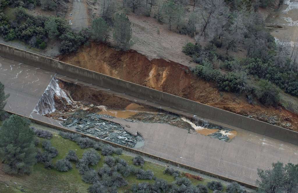
A few observations on this picture. IIRC, this was taken after the initial failure was discovered, and prior to the "test" of the system which resulted in additional damage.

Notice on the right side how much soil has sloughed off the embankment. Did water splash out of the spillway and cause that erosion, or was it from a faulty drain?

Also, at this point, some of the slab was still intact next to the wall. I cannot determine if by this point the wall was undermined and connected to the exterior erosion.

When I first looked at this pic I figured it was from turbulent splash over the walls. Yet the erosion is pretty far up the spillway for that. I can speculate possibilities:

1 Spillway slab failed and resultant rooster tail splash over wall eroded hill. Then either up-spillway side slumped or drain pipe broke and eroded hill.
2 Spillway slab failed then scoured under wall, eroding hillside
3 Piping (water moving through soil erosion) under slab and wall created void and eventually failed spillway slab and eroded hillside
 
A couple of links:

Speculations as to the cause of failure in the media:
http://www.chicoer.com/general-news...possible-culprit-in-oroville-spillway-failure
- Cavitation
- Drought drying material under slab, creating voids

Geological speculations:
https://www.google.com/amp/www.forb...oroville-dam/amp/?client=ms-android-sprint-us
He call the more orange formation "altered" and that would make it weaker.

There does seem to be something about this spot of the spillway, but correlation is not necessarily causation.

What's your opinion on cavitation? If that be the case, every dam in the world with a concrete spillway is in danger, unless the surface is flawlessly smooth. At first blush, that looks to be a CYA theory put out by bureaucrats. MOO, of course.
 
Thank you, Eric. That makes sense. I have yet to find a detailed modeling for a worst case scenario and what the flow would look like with a complete breach. Researching the St. Francis Dam and the flow traveled 54 miles and hearing Oroville has 600x more water behind it, I am curious how far a true breach would flow and how outstretched across the valley it could go? Could it go around the Buttes into Williams or would it dive down the 70 corridor into Sacramento?

*Grew up in Gridley and now based in Pennsylvania.
I think the current Worst Case is that a section, likely a fairly short section, of the weir gets undercut and collapses. Depending on the composition of the plateau upstream from the weir, and its erosional rate, you might have something like a 50' x 50' hole in the e-dam before too long. That would flow _very_ roughly the same volume of water as the main spillway. This is a lot of water, but it would be NOTHING like the St. Francis collapse, where half of the main dam failed within a minute or two, creating a MUCH larger hole, backed with water under higher pressure. When it became clear that the weir was failing, operators would close the main spillway to reduce overall flow down the river.

Once a section of the weir failed, I'd imaging that further undercutting might nibble at the edges of the breach, expanding it over time. This rate of 'nibbling' would determine just how bad this worst case becomes. In no case can I imagine the entire mountain beneath the e-spillway eroding away fast enough to matter. The small area of rock beneath the main spillway are holding up fairly well in the face of an ongoing explosion of water.

Worst case? Modest flooding in Oroville. Sacramento washed into the ocean? Never.
 
Last edited:
What's your opinion on cavitation? If that be the case, every dam in the world with a concrete spillway is in danger, unless the surface is flawlessly smooth. At first blush, that looks to be a CYA theory put out by bureaucrats. MOO, of course.

Cavitation is easy to analyze and relatively cheap to fix. The responsible CA DWR engineers or administrators should be [fired] if they cannot produce a spillway cavitation analysis or proof that they added some aeration to the flow as it is well-studied and well known problem. We could ballpark a cavitation analysis.

https://www.usbr.gov/ssle/damsafety/risk/BestPractices/Chapters/VI-3-20150610.pdf

upload_2017-2-17_10-0-9.png


Cavitation damage risk goes up the longer the spillway operates. The key parameter to calculate is the cavitation index which primarily depends on the velocity of flow in the chute. First step would be to figure out when the damage occurred, what the flow was, then estimate a depth and velocity. I discounted cavitation at first because the spillway has operated at higher flows before with no damage, but that doesn't mean they weren't in the risk zone. Edit: It's interesting to note that extending the hours of operation from 1 day to 1 month for a given cavitation index can move the risk from no damage to major damage.

Edit: given Pozzolith's notation of the eroded hillside a couple of posts up, if even minor cavitation damage resulted in a rooster tail that eroded the hillside, then cavitation could be the spark that lit the flame. For cavitation to be ruled out, the calculation should end up below the dashed line in the graph above, imo.
 
Last edited by a moderator:
Cavitation is easy to analyze and relatively cheap to fix. The responsible CA DWR engineers or administrators should be lined up and shot at dawn if they cannot produce a spillway cavitation analysis or proof that they added some aeration to the flow as it is well-studied and well known problem. We could ballpark a cavitation analysis.

https://www.usbr.gov/ssle/damsafety/risk/BestPractices/Chapters/VI-3-20150610.pdf

upload_2017-2-17_10-0-9.png

Cavitation damage risk goes up the longer the spillway operates. The key parameter to calculate is the cavitation index which primarily depends on the velocity of flow in the chute. First step would be to figure out when the damage occurred, what the flow was, then estimate a depth and velocity. I discounted cavitation at first because the spillway has operated at higher flows before with no damage, but that doesn't mean they weren't in the risk zone.
Just finished reading the exact same paper and it describes the current situation almost to a T. This is a well known type of situation as can be seen in the chart. However, the presence of drains and anchors below the floor of the spillway means that the designers knew it needed to be addressed. But the spillway has now reached a point in its design life where expensive upgrades are needed.
 
Your comment about the drain openings being at too slight a depth beneath the ground misses my main point (and indeed, the drain outlets I saw most clearly were at an elevation just slightly below ground level), which is that the water is actually coming from farther up the slope of the spillway, not from the surrounding land.

... the flow from those outlets could not have originated from the surrounding land (and I can't imagine a scenario where all the drains could run that way just based on groundwater, especially on a site that is so high and dry.

... There is a long sloping pipe, matching the slope of the main spillway. This pipe has regularly-spaced vertical branches which are all the same length and open at the top end. If you fill that long sloping pipe with water, water will exit the ends of every vertical pipe that has an opening which is lower than the water at the far uphill end of the main pipe. In hydraulic principle, it's actually no different than poking a bunch of holes in the side of a bucket, with a constant increment of height change from one hole to the next (all the holes will spurt water if the bucket is full).

To finish up, the idea that a broken pipe would erode material beneath the slab is basically correct, but I'm working on the assumption that there already is a large amount of water under the slab that wants to flow downhill, and the drain system was put there to keep that water from developing severe pressure or un-contained flow.

Here is the picture --

upload_2017-2-17_9-49-40.png
I think we are in general agreement.

My comment was intended to provide evidence the side openings must be connected to piping that is feeding them with water that is pressurized by the elevation difference along the pipe. (I think this is consistent with your comments.) The shallow burial of the openings precludes a non-piped opening from developing any significant pressure because a few psi would be sufficient to flood the ground surface. (A prior commenter suggested the openings are not piped.) It is not possible to develop sufficient pressure to generate these flowrates merely from the hydrostatic pressure that could exist between the outlet and the adjacent ground surface.


My interest in piping is that a pressurized pipe can be much more erosive than water permeating through saturated fill. Freewater flow through soil can and does lead to erosion (this effect took out a foundation in my home), but outflow from a pressurized pipe can be more aggressive -- example is placer mining.

I suggest an unproven hypothesis -- over years, slow water permeation under the slab slowly eroded support eventually leading to enough shift to break one or more drain pipes. Flow through that drain pipe accelerated the erosion and undermining. This is consistent with the seepage at the sinkhole origin.

Earlier in this thread there was discussion the drains were not piped. My comments were to question that idea. Now the topic has its own thread. https://www.metabunk.org/oroville-dam-drains-in-the-spillway-walls-how-do-they-work.t8407/ That thread seems to be tilting toward the outlets being piped.

 
Perhaps that gouge in front of the apron is being used to wash out the cement trucks after they've unloaded. They do that on site generally; and there seems to be a lot of it :)

upload_2017-2-17_11-59-53.png
 
I looked for pictures showing the wall backfill, and I found some interesting shots on the website for the California Department of Water Projects. Unfortunately, their photos of the Oroville Dam can't be copied, downloaded, or even linked to (links are of no use because the only links you can copy are for individual pages which have a large number of photos - there's no separate link to the individual photos).
It's most likely possible to do a screenshot of the image you want, and then upload it here. Not the best way of sharing an image, but better than not.
 
Last edited by a moderator:
I looked for pictures showing the wall backfill, and I found some interesting shots on the website for the California Department of Water Projects. Unfortunately, their photos of the Oroville Dam can't be copied, downloaded, or even linked to (links are of no use because the only links you can copy are for individual pages which have a large number of photos - there's no separate link to the individual photos).

Which page?. I can explain how to extract images.
 
Conditions of the levees in Yuba City.

The work that is beginning to repair seepage and boils has caused a local rumor mill to go into overdrive about potential threats of levee failure in Yuba City. Water level has been steady at 66 feet, but I continue to keep my eye on this aspect. As long as dam outflows continue to be steady or decreased, there shouldn't be significant change to the water level.

Sounds like complete levee failure is unlikely and city and county resources are being deployed proactively to address weak spots in the levees.

I found the video images of seepage and boils informative for the conversation we had way back on page 8.

http://fox40.com/2017/02/15/feather-river-levee-to-undergo-preventive-repairs/
 
Estimated 20 million customers, repairs at $100 to $1000 millions = $5 to $100 one off charge to each customer. Remove the political hype and the customers are going to have to pay a dollar or two extra each month over the next year or two. When you next pay your water bill make a donation specific to Oroville dam spillway repair, legally they have to allocate the money to that. (English sense of humour).
I would be very surprised if there were 20 million customers of that dam. That's more than half the population of California. It's possible that it contributes a few drops to that many people, but not a significant amount. While it's the second largest dam in the state (by volume), when I add up the volumes of the top 25 (per Wiki, not the best source but easy) I get around 30,800,000 acre feet and Oroville is around 11% of that.

In reality, while 11% of CA is around 4 million people, my understanding is that Oroville mostly goes to agricultural uses so it's likely far fewer customers than that (and therefore far higher per customer cost).
 
No, it is not a drain. The drains are still trapped under the weir. It also has been mentioned in this discussion that some of the drains [ were might have been ] fashioned out of wood due to uneven rock shapes.

What is your source of information?

Watching the dam safety video series, it seems like it could very well be a pipe to take drained material away from the E-spillway and down the slope to allow it to run off on the surface rather than into the ridge that is crucial to the dams structure. Just seems your very sure, with no corroboration just an opinion stated as fact.
 
Moderation Note
Please back up statements with concise quotes, links (with excerpts) - and preferably annotated images.
 
No, it is not a drain. The drains are still trapped under the weir. It also has been mentioned in this discussion that some of the drains [ were might have been ] fashioned out of wood due to uneven rock shapes.

The drains weren't "fashioned out of wood" ... they would have been formed using wood forms ... the drains are in the concrete base of the weir and once formed the wood is immaterial
 
What is your source of information?

Watching the dam safety video series, it seems like it could very well be a pipe to take drained material away from the E-spillway and down the slope to allow it to run off on the surface rather than into the ridge that is crucial to the dams structure. Just seems your very sure, with no corroboration just an opinion stated as fact.

Detail of the e-spillway drain from https://archive.org/stream/zh9californiastatew2003calirich#page/96/mode/2up

upload_2017-2-17_14-3-52.png
upload_2017-2-17_14-6-11.png

shows how the drains were void-formed from lumber with concrete placed around and over.
 
My comment was intended to provide evidence the side openings must be connected to piping that is feeding them with water that is pressurized by the elevation difference along the pipe. (I think this is consistent with your comments.) The shallow burial of the openings precludes a non-piped opening from developing any significant pressure because a few psi would be sufficient to flood the ground surface. (A prior commenter suggested the openings are not piped.) It is not possible to develop sufficient pressure to generate these flowrates merely from the hydrostatic pressure that could exist between the outlet and the adjacent ground surface.
Thank you for the clarification, and yes, we are in agreement, but to clarify things from my end, that "prior commenter" also was me, before additional information prompted me to realize it must be actual pipes, not open-graded backfill which was conducting the downhill flow outside the walls. You see, open-graded backfill would work for that, and that earlier guess was based on the little bit of info I had about the backfill. Then last night I found some photos indicating that the deeper backfill was a soil type that would not conduct that volume of water. Later in the evening I modified my best guess a little more but didn't come back to write about it, and that turned out to be roughly the same as how the system was determined by others to be laid out. All along I've been trying to avoid sounding like I'm totally sure of myself!
 
Last edited:
Bill Croyle at the press conference:
  • Inflow 27K, out 80K, elevation 861 feet. Dropping 4" per hour
  • Going to reduce outflows again. To 70K at 1PM today. For the power plant, and downstream levees
  • Spillway has been stable so far.
  • Down to 60K tomorrow.
  • They need to reduce the outflows as the level lowers, but need to do it carefully as changes might impact the spillway stability.
  • Forecast for this storm is is a max lake elevation of "slightly over" over 861
  • About a week to get power plant working
 
Detail of the e-spillway drain from https://archive.org/stream/zh9californiastatew2003calirich#page/96/mode/2up

upload_2017-2-17_14-3-52.png
upload_2017-2-17_14-6-11.png

shows how the drains were void-formed from lumber with concrete placed around and over.

Part of this is my assumption that while a drain cavity was formed in the Espill that cavity needs a path to remove material from within the structure, this is not specified in the documentation but it is my experience having worked as a gardener and installed maybe 20-30 drains that they go somewhere, they dont just exist as a conceptual theory they transport fluids from one place to another through a conduit. This is just my opinion based on my experience, but I doubt very highly the drains in the Espill directed fluids down into the 'competent bedrock' they make mention of taking extra care to reach. Its my guess, with limited education in a few different work capacities digging ditches and installing drains and irrigation, that there are pipes and they proceed downhill to release the water on the surface away from the structure. This is why I asked about the pipe. I could be wrong and at this point since its become a bit weird towards this line of questioning I would rather just drop it. I did assume that the drain needs to transport through a conduit, saw the word drains with an 's' on the end and wondered about the proximity, but this is not worth the hassle so if its just me that cares forget about it.
 
Last edited:
...However, the presence of drains and anchors below the floor of the spillway means that the designers knew it needed to be addressed. ....

I would not go that far. The definitive cure for cavitation is adequate aeration of the flow as the paper indicates. Anchoring and drainage are at best secondary measures as cavitation can spall concrete regardless of how well it is anchored or drained.

These media reports are speculative in that they are insinuating there is no cavitation protection (aeration). Modern protection might be manifested by ramps or aerators in the chutes, but I don't see any (doesn't mean they are not there). It could be the radial gate outlets work in such a manner as to provide adequate aeration in the designer's and maintainer's view, or there is something else we are not privy to.

Nevertheless, your point about the age of the spillway is valid and if media reports are valid that they inspected the spillway from a distance (http://www.redding.com/story/news/2017/02/09/dam-spillway-checked-distance-last-inspection/97723936/), then they will face criticism, because any differential settlement of the panels could exacerbate cavitation as highlighted in the paper.
 
I think the current Worst Case is that a section, likely a fairly short section, of the weir gets undercut and collapses. Depending on the composition of the plateau upstream from the weir, and its erosional rate, you might have something like a 50' x 50' hole in the e-dam before too long. That would flow _very_ roughly the same volume of water as the main spillway. This is a lot of water, but it would be NOTHING like the St. Francis collapse, where half of the main dam failed within a minute or two, creating a MUCH larger hole, backed with water under higher pressure. When it became clear that the weir was failing, operators would close the main spillway to reduce overall flow down the river.

Once a section of the weir failed, I'd imaging that further undercutting might nibble at the edges of the breach, expanding it over time. This rate of 'nibbling' would determine just how bad this worst case becomes. In no case can I imagine the entire mountain beneath the e-spillway eroding away fast enough to matter. The small area of rock beneath the main spillway are holding up fairly well in the face of an ongoing explosion of water.

Worst case? Modest flooding in Oroville. Sacramento washed into the ocean? Never.

We know from current pictures that there is good stable bedrock underlying the emergency spillway weir area.

We know from construction documents that the builders went to extra effort and expense to insure they had solid, foundational bedrock supporting the weir - that they overcut until the found good bedrock and backfilled with concrete before constructing the weir.

We know from observing the hillside channel - which carried almost all of the consolidated flow of the entire emergency weir - that this blue-green bedrock does not erode under significant pressure from a 10,000+ cfs flow.

We know the 100,000 ton or more heavy concrete emergency weir is sitting on bedrock and 10 feet or more in some areas of concrete ... and neither the weir or that bedrock is ever likely to be backcut through to a point of failure.

We therefore can say with a far good degree of certainty the emergency ogee weir is highly unlikely to fail due to undercutting.

And if it did fail, as the poster quoted notes, it is unlikely that IF a failure occurred it would take out the entire weir. It is also unlikely, due to the known bedrock underlying the weir and hillside, that any failure would progress more than a few feet deeper before being met by that bedrock.
 
Serious question: In the event of an ESpill failure could it be enough force to carry these bags of rocks downstream enough to contribute to the damage? Could we have a nightmare scenario where we find these bags of rocks strewn about the valley with a complete dam failure?

There is an effectively tiny amount of material there. A major failure could create sufficient force to move these bags of rock but that would have almost zero effect on anything due to their very small amount, and the small size of the rocks in them.
 
Shadowwalker, that is a *Great_Find*! .... 710 pages of the 1975 Oroville Earthquake Investigations. Thank you!
Sorry if I didn't put the page number - it is 292 and 293. Also something I found interesting - no where in the report (so far)does it mention emg. spillway, aux. spillway, etc. Just monoliths.
 
Thank you, Eric. That makes sense. I have yet to find a detailed modeling for a worst case scenario and what the flow would look like with a complete breach. Researching the St. Francis Dam and the flow traveled 54 miles and hearing Oroville has 600x more water behind it, I am curious how far a true breach would flow and how outstretched across the valley it could go? Could it go around the Buttes into Williams or would it dive down the 70 corridor into Sacramento?

*Grew up in Gridley and now based in Pennsylvania.

A complete breach of the entire dam is a near impossibility from the current situation. The earthen dam is topped at elevation 923 ... the emergency spillway is 901. The underlying bedrock at the emergency spillway is something around 830 to 840 worst case scenario.

Both the main and emergency spillways are separated from the dam itself by an 850+ ridge of bedrock. A failure of the main channel would cause flow away from the main spillway, and downslope toward the channel down the hillside from the emergency spillway.

Any failure at the emergency spillway would occur at 901 or below. And would bne constrained upon reaching bedrock at appx 840.

In extremely unlikely event the main dam was threatened a simple set of charges at the emergency spillway would create a breach that would fairly rapidly drain down to 840 elevation.
 
In extremely unlikely event the main dam was threatened a simple set of charges at the emergency spillway would create a breach that would fairly rapidly drain down to 840 elevation.

Is this something you suspect is part of their contingency plans?
 
Perhaps that gouge in front of the apron is being used to wash out the cement trucks after they've unloaded. They do that on site generally; and there seems to be a lot of it :)

upload_2017-2-17_11-59-53.png


That "gouge" is also in front of not only the 60' wide at the base concrete weir but also the 12' thick apron in front of it that goes down well below the cut ...
 
I would be very surprised if there were 20 million customers of that dam. That's more than half the population of California. It's possible that it contributes a few drops to that many people, but not a significant amount. While it's the second largest dam in the state (by volume), when I add up the volumes of the top 25 (per Wiki, not the best source but easy) I get around 30,800,000 acre feet and Oroville is around 11% of that.

In reality, while 11% of CA is around 4 million people, my understanding is that Oroville mostly goes to agricultural uses so it's likely far fewer customers than that (and therefore far higher per customer cost).

It is part of a statewide water system that benefits all. If you think this is an important point then divide the cost by the population of the state.
 
Status
Not open for further replies.
Back
Top