Oroville Dam Spillway Failure

Status
Not open for further replies.
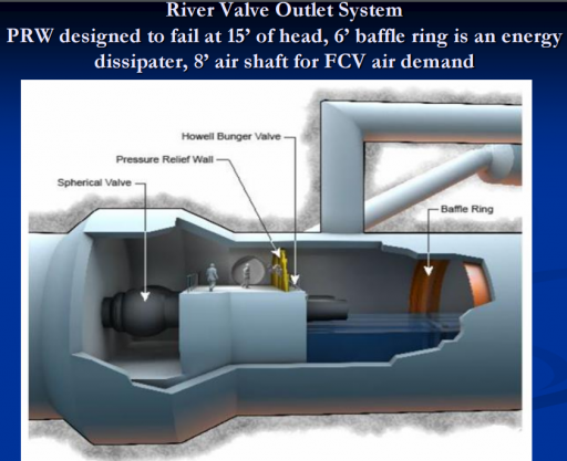
As built - the cut toward top of hill appears to be the intakes seen below the main spillway ... they are at appx the 720 elevation I believe ...


Any idea what this "river valve" system could have released, flow-wise? http://www.abc10.com/news/local/riv...-fourth-way-to-release-excess-water/408086236
I had no idea these existed but I found some information that indicates these valves were fixed and may have been operational as recently as 2014. They could have them open right now and we don't even know it. Although I would think that they would have at least mentioned it in passing at a press conference.

https://mavensnotebook.com/2015/10/...ulation-update-on-state-water-project-issues/
California Water Commission_ on Basin.png
 
Just wanted to say thanks for this thread, I'm a half mile from the dam and 1.5 miles from the spillway, so updated and accurate information is vital.
 
Given all the erosion damage and the loss of the road below the emergency spillway, are they currently able to get trucks and heavy equipment the whole way across the area that needs immediate repairs? Or are they only able to drop bags of rocks via helicopter into some of the holes?
 
Home Video shows construction work, from a long way off, but you can see the machinery and a lot of rocks.

Source: https://www.youtube.com/watch?v=ux9MSHoVL2g


Actually a useful video ... appears they have rebuilt at least a construction access to area below the weir ... which means they have filled the ravine below the right end of the weir (as viewed in the video) - next to the main spillway.

Looks like they have been/are hauling in large boulders and a dozer is pushing them into the cut area at parking lot end of the weir ...

One would hope they will then get some smaller rock on top of the bench below apron and run concrete trucks in as fast as they can to extend the hard apron at leas as far as they can on the relatively flat top of the bench.
 
Last edited by a moderator:

Attachments

  • 2017-02-14 14_24_51.png
    2017-02-14 14_24_51.png
    629.9 KB · Views: 442
  • 2017-02-14 14_25_28.png
    2017-02-14 14_25_28.png
    496.4 KB · Views: 388
  • 2017-02-14 14_25_51.png
    2017-02-14 14_25_51.png
    1.3 MB · Views: 385
Last edited:
There's an excellent resource for information and updates on Facebook, if anyone is reading this who is in the area. It's called Randy's Reliable Updates, it's a group. Randy is a former firefighter who usually focuses on fires but occasionally when there's another big event he'll give fact-checked and non-sensational updates to those who need them. I used his group for the Lowell Fire in Nevada City two years ago and the Soberanes Fire in Big Sur back in July. The updates aren't as technical and number-heavy as those you'll see here, but they're great. You'll need to join and a ton of people are going to be trying to get in, so be patient, but it's very good. If you live in NorCal, you should be in this group.
https://www.facebook.com/groups/742908632434139/?fref=nf

(mods: remove if necessary, i just imagine there's a lot of people here who could use this resource and it's in the same vein as MB)
 
Given all the erosion damage and the loss of the road below the emergency spillway, are they currently able to get trucks and heavy equipment the whole way across the area that needs immediate repairs? Or are they only able to drop bags of rocks via helicopter into some of the holes?


The video above shows gravel trucks, a dozer and a large tracked backhoe on the bench at base of the emergency spillway weir ... so to the area of damage at least the answer appears to be yes ... and I suspect once the damage toward parking lot end is filled - they probably could access that area as well

I think it'd be smart to stockpile a bunch of heavy equipment and material on safe ground behind the parking lot where they could have access to make repairs if needed


Looks like they have been/are hauling in large boulders and a dozer is pushing them into the cut area at parking lot end of the weir ...
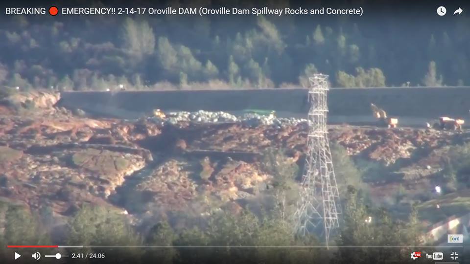
There also seems to be a crane or concrete boom (the green thing), maybe adding concrete on to the rocks.
 
Yesterday's KCRA livestream of the damage and the rocks drops is archive on Facebook. Nothing new really, but a good set of overview shots.
https://www.facebook.com/KCRA3/videos/10155029133956514/?permPage=1
20170214-124913-6j4mf.jpg
The video above shows gravel trucks, a dozer and a large tracked backhoe on the bench at base of the emergency spillway weir ... so to the area of damage at least the answer appears to be yes ... and I suspect once the damage toward parking lot end is filled - they probably could access that area as well

Yes, they obviously have a plan to do things a certain order - partly for the most urgent areas, but also to build access for trucks which can bring in far more material than the helicopters - and can also bring in the cement.

I think they are essentially going to have to build another quick broken rock road across the area then fill the area between the road and the weir with rocks and cement.
 
This is a little ahead of things, but when people have a chance, I'd like to hear thoughts. A friend of mine worries that all this "lost" water will a) discourage people from conserving once the rain stops and b) increase pressure to add more dams to "capture" "wasted" water. Another friend told me (he has an engineering background) that in actuality, not much water is being "wasted," since the Delta pumps that feed our irrigation system are so far downstream. But my first friend tells me that the SF Bay is now very fresh, which indicates the pumps are not catching all of it. Perhaps this is seasonal freshness. And, of course, the ocean and Bay need fresh water, too, but I'm worried there will be a clamour for dams after all the scary stuff dies down.
 
I found some useful information about the Feather River in Yuba City. Currently at Flood Stage II and slowly rising. Looks like they are a little slow at getting the data into the system, but this will be important information for the folks downstream, as they have levee issues and dam issues to contend with.
http://www.yubacity.net/city_hall/d...dplain_management/monitor_local_water_levels/

Stage Elevation Description
Stage I 60 Pre-emergency. River level is at 60’ and forecast to rise. Feather River flows over the banks of the main channel at this elevation. River is monitored on a 24-hour basis.
Stage II 65 Warning Stage. River level is at 65’ and forecast to rise. River is monitored at a minimum of twice a day with a levee patrol.
Stage III 70 Full Alert Stage. River level is at 70’ and forecast to rise. Flooding is possible, but not probable. River is monitored on an hourly basis by levee patrols.
Stage IV 75 Emergency Stage. River level is between 75’ – 77’ and forecast to rise. Flooding is expected in south areas of the County. Hourly levee patrols continue.
Stage V 77 Evacuation Stage. River level is at 77’ and forecast to rise. The river poses a significant flood threat. Hourly levee patrols continue.

02/14/2017 01:00 65.39
02/14/2017 01:15 65.45
02/14/2017 01:30 65.51
02/14/2017 01:45 65.55
02/14/2017 02:00 65.59
02/14/2017 02:15 65.55
02/14/2017 02:30 65.53
02/14/2017 02:45 65.68
02/14/2017 03:00 65.67
02/14/2017 03:15 65.74
02/14/2017 03:30 65.72
02/14/2017 03:45 65.77
02/14/2017 04:00 65.82
02/14/2017 04:15 65.84
02/14/2017 04:30 65.87
02/14/2017 04:45 65.87
02/14/2017 05:00 65.89
02/14/2017 05:15 65.95
02/14/2017 05:30 65.97
02/14/2017 05:45 65.96
02/14/2017 06:00 66.01
02/14/2017 06:15 66.03
02/14/2017 06:30 66.03
02/14/2017 06:45 66.08
02/14/2017 07:00 66.05
02/14/2017 07:15 66.12
02/14/2017 07:30 66.14
02/14/2017 07:45 66.13
02/14/2017 08:00 66.08
02/14/2017 08:15 66.14
02/14/2017 08:30 66.19
02/14/2017 08:45 66.19
02/14/2017 09:00 66.24
02/14/2017 09:15 66.24
02/14/2017 09:30 66.23
02/14/2017 09:45 66.21
02/14/2017 10:00 66.28
02/14/2017 10:15 66.26
02/14/2017 10:30 66.27
02/14/2017 10:45 66.31
 
Evacuations haven't been lifted yet.
Some Yuba City residents returned home, apparently. This was my family member, so I deleted the post because when I tried to confirm, I could not... News conference now. I'll tune in!
 
I'd like to hear thoughts.

I am sure their will be (already is) lots of clamoring and finger pointing from/to all sides. The reality is almost all major rivers in CA have at least one if not multiple dams on them already. There really are not a lot of viable possibilities left that could make a significant impact in water storage.
 
Thanks all for this wonderful thread.

Would like to post with more detail, but at work. But will quickly adress a few points.

Regarding boils, in the flood control community, this term refers to the expression of underseepage piping, which occurs when water seeps under a levee or dam and upwells in a concentrated flow. This concentrated flow starts to erode the subsurface where it exits the ground and then continues under the levee or dam until it reaches the waterside. Piping can erode large enough cavities from the subsuface that the structure collapses, resulting in a complete structural failure.

The concentrated flow upwelling landside of the structure has the appearance of boiling water, hence the term "boil". As concentrated flow moves through the subsurface, the eroded path is referred to as a pipe, hence the term "piping". When piping is actively eroding the subsurface, sediment can be seen in the upwelling concentrated flow, and sediment is typically deposited around the boil, creating a sand cone. These boils are referred to as "sand boils" or even "dirty boils". When piping is not actively eroding the subsurface, boils are referred tonas "running clear". While non-eroding piping doesn't necessarily pose immediate structural threats, there's a saying that "there's no suxh thing as a good boil."

Piping can also occur through the embankment. While this occurs, it's typically not referred to as a boil, but as simply piping or through seepage piping. Through seepage piping can also cause complete structural failure.

Potential for piping depends on soil type, statigraphy, and the ratio between the seepage path (the distance seepage has to travel to reach the landside) and the amount of hydraulic head (the difference between the landside elevation where seepage would upwell and the water surface behind the structure causing thr seepage). A quick back-of-the-envelope estimate can be obtained by dividing the seepage path by the head. This is called the Creep Ratio. It's been calculate for numerous and levees that have and haven't failed due to underseepag, and the results have been tabulated against foundation soil type, providing an quick reference for order-of-magnitude-type assessments.

As was previously indicated, levees along the Sacramento and San Jauquin River Systems are notoriously susceptible to piping hazards. This is largely due to the "blanket"-type deposits of meadering rivers, where permeable materials are deposited laterally only to be covered by lower permeable materials during subsequent flood events. This allows strong subsurface pressures to build, eventually causing the overlying blankets to heave and crack. Water compensates for less volume by increasing velocity, so small cracks can cause concentrated flow at high enough velocity to initiate subsurface erosion. And levees are constructed from area soils, which are sometimes susceptible to internal erosion, especially if ground squirrels provide burrows that initatie piping.

Oroville Dam is in a radically different geologic setting, as already indicated. Even were piping to occur, it would not necesarily be as dire as it is along the valley river levees. It would be completely probable for pips to form through fractures and fissures, causing some initial erosion, but ultimate running clear and not causing substantial voids to compromise overall structural strength. Still, the reports of potential piping or boils are extremely concerning and could conceivable be consistent with erosion decreasing seepage path lenghts.

I have more to write, but I need to get back to work now. Thanks for all the great information.
 
He thinks that even with rain coming in they'll still be able to reduce the lake to 850 ft by Saturday. I don't understand the math there. Seems like he's making an assumption of continued inflow of 19,000?
 
He thinks that even with rain coming in they'll still be able to reduce the lake to 850 ft by Saturday. I don't understand the math there. Seems like he's making an assumption of continued inflow of 19,000?

It does not seem too unreasonable. Rain levels are fairly low. Inflow will decrease more for about 48 hours.
 
I think it'd be smart to stockpile a bunch of heavy equipment and material on safe ground behind the parking lot where they could have access to make repairs if needed

The big parking lot behind the emergency spillway is, ahem, prone to flooding, and can be sacrificed as much as the [now missing] roadway. They have plenty of parking spots available nearby, as you can easily see on Google Maps, and more tools than we know of.

The situation is basically under control now, but dependent on the normal overflow valves and spillway. The crisis happened due to trying to minimize damage to the damaged spillway. We get to watch whether something changes, while the engineers get to study and work more on the long-ignored emergency spillway.
 
It does not seem too unreasonable. Rain levels are fairly low. Inflow will decrease more for about 48 hours.
Because of the temperature of the storm and snow level? I'd love to see their model.

But in general, from what they are saying... seems like they are gaining confidence in their control of the situation.
 
Because of the temperature of the storm and snow level? I'd love to see their model.
Also just a smaller storm. Less moisture over less time.

But in general, from what they are saying... seems like they are gaining confidence in their control of the situation.

They are perfectly fine so long as the main spillway holds (it has been solid for three days). Then they will have to use the emergency spillway, which is why they are reinforcing it.

There's a very slim chance of a super storm which would need more that 100K cfs (account for the extra space they will make). They can bump up the main spillway outflow to over 200K, however then that increases the risk of failure.

Things are deceptively stable right now. It all hinges on just how long the main spillway will last - and they can't really get a good handle on that without turning it off.
 
They've made a ton of progress in 36 hrs based on the new photos coming out. I was interested that they were using concrete and rock to reinforce the rest of the emergency/auxiliary spillway in a manner similar to the concrete coping at the bottom of the other 3/4 of it.
 
To me the seemingly lackadaisical attitude - ONE dozer, ONE backhoe, and ONE concrete pumper ... no apparent urgency - is amazing ...

And a line of storms less than 24 hours out ...

In a situation like this I would have mobilized a bunch of equipment. Gotten at least a haul road re-established all the way thru to the parking lot ... and been trucking in materials as fast as possible 24/7 and getting them stockpiled

Get heavy equipment ( dozers, dump trucks, backhoes etc.) and material stockpiles staged at the parking lot end and the dam end ...

The flows even at 902.58 at the parking lot end were such that equipment would have no problem working in the flow if a problem occurred. I suspect the heavy equipment could even probably work in the flows below the weir in an emergency,
 
Last edited:
Ideally they could get a concrete and rock cover down to where the water has stripped the hillside down to rock. The problem occurs when water has to run over erodible ground and back cuts. That's a very large area though.

It is truly amazing to me the entirely lackadaisical apparent attitude ... ONE dozer, ONE backhoe, and ONE concrete pumper ... no apparent urgency ...

There's a constant stream of both trucks and helicopters going up there. The first concern is getting the rocks into place.
 
It is truly amazing to me the entirely lackadaisical apparent attitude ... ONE dozer, ONE backhoe, and ONE concrete pumper ... no apparent urgency ...

You can only move as much material and pump as much concrete as can be brought in by truck, and they appear to have the trucks running continuously. If they could use more equipment, you can be sure they'd have it.
 
It is truly amazing to me the entirely lackadaisical apparent attitude ... ONE dozer, ONE backhoe, and ONE concrete pumper ... no apparent urgency ...

What you're seeing there is just doing simple and obvious tasks. Patching things.

The hard work right now is happening in an engineering team somewhere, and in the scattered people you might spot wandering around -- geologists, engineers, and surveyors gathering information.

After someone decides that there is a need for a certain solution, then you'll see physical activity on site.
 
Status
Not open for further replies.
Back
Top