Observations of Mallorca Island and the Earth's Curvature

PeteShasta

Banned
Banned
Admin Note
The following post was made by @jeranism, using a fake account "PeteShasta". This is a bannable rule violation.


I have been watching this forum and the videos made by Eric Dubaz, Jeranism and Mark Sargent for about a year now. I thought the flat earth dudes were ridiculous. Dumbest thing I had ever heard. When one of them makes a decent post, I have come here and seen it squarely debunked. But now I have come across some observations I need debunked please.

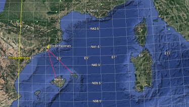
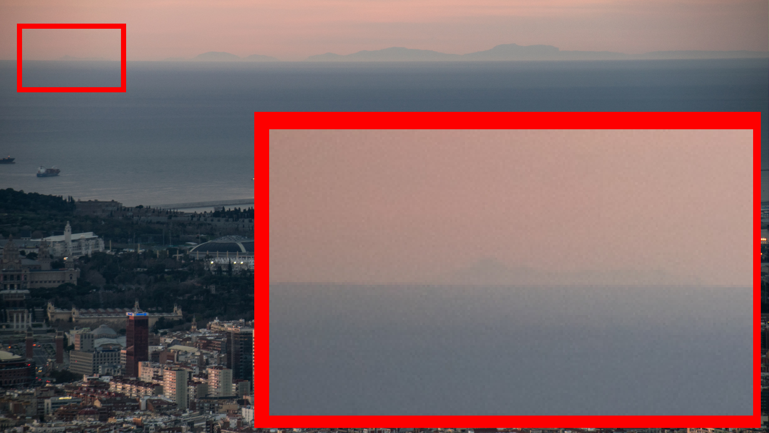
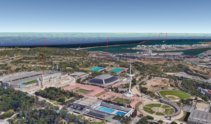
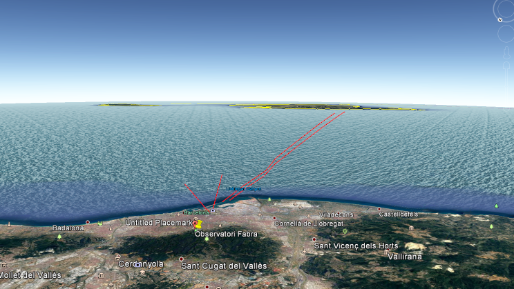
This is a phot taken from Observatori Fabra of the Mallorca islands. The island on the left is what has really intrigued me. That island is 133 miles away and the Observatory is 1362 feet high. When this is entered in Metabunk calculator, I get with refraction 4000 feet hidden. The island on the left... is 500 feet high. Unless someone can explain this, I now think the 3 guys above may be doing a service to the world. Could it actually be flat?


Last edited by a moderator:
The island on the left... is 500 feet high.
That's not the island on the left, it's all part of the same island. What you see on the left is a 3,500 foot peak called Puig Tomir

20170928-093406-dcbof.jpg

20170928-093446-7d1wu.jpg

20170928-093943-grrap.jpg

20170928-094742-twon5.jpg

(Actually 3,615 ft, but close enough)
 
Last edited:
No, you need to look further left. The small island can easily be seen. If this was over 500 feet I would not have joined the site and stated that I now doubt the globe. The island on the left is why I am in doubt.

 
Still part of the same island. That's another ridge/mountain near Castell del Rei, about 2,600 feet high.

20170928-102401-wcnpb.jpg
 
I thought you might be right but I looked again and in fact you aren't right at all. Swoop down via google earth to get the same view as the photo and draw lines running from the harbor docks, then the stadium, and then the building to the left like this:


Then raise your point of view to see what direction we are seeing like this:


Clearly, the island is what is seen in the image of the original post. Mick, I always thought you were really honest but now I am doubting that because I think you see that refraction can no longer explain the sighting. We are looking at a 500 foot peak from 133 miles away. Can you admit it now that we are seeing the island?
 
There's no use. You are being quite dishonest. Even Peak finder shows none of this should be visible. I never thought I'd take their side but you clearly are ignoring facts. Max height is 1000 feet of that island/peak. And with refraction you shouldn't see less than 4000. You are in denial
 
What that means is that you are seeing 133 miles distant and since according to you we see nothing but Mallorca, then we are looking at only 50 miles. Are you being serious?
 
Pete, I've very clearly explained above that you are just looking at the Island of Mallorca. The peaks you can see are over 2,500 feet, so they are visible over the horizon. This can be verified in a variety of ways which I illustrate above.

The island of Menorca is not visible in your photo.

Would you like to do a Google Hangout, so I can share my screen and show this to you?
 
Unless someone can explain this, I now think the 3 guys above may be doing a service to the world. Could it actually be flat?
Though it's been clearly explained above that there's nothing unusual with the photo presented in the OP, I'm intrigued as to why, even if there had been something odd about it, this would have made you think the earth is flat. Let's say you've looked at 200 pieces of evidence and all of them debunked the flat earth, why would one indistinct photo requiring further investigation sway you to such an extent? Something I've often found curious...
 
To be honest I never even thought for one moment it could be flat until today. It seemed, and as time went on, it became frustrating that nobody from a science point of view had stepped up to put this to bed. I researched refraction and found it to really be circular reasoning but accepted that. The recent media foul ups with Kyrie made me start thinking why do they say he back tracked if he didn't. Then I saw this post at The Verge https://www.theverge.com/tldr/2017/...tellite-gofundme-scam-crowdfunding-conspiracy and saw in the post they included the video that is clearly go-pro footage as proof of the curve. So, this morning I saw this view of Mallorca. If what you are all saying is correct, then look at these numbers. We are seeing 133 miles in the distance, that is the radius of our view circle. So 2piR gives us 835 mi circumference. 835/360= 2.32 mi/deg. So, according to Mick, the island takes up our entire view... so that is 50 miles or 21 degrees of view?

Then, honestly the way that Mick just was first wrong about which peak it was, by giving a peak 3,500 feet high when the refraction number gives us anything below 4,000 cannot be seen. Then, he changes his mind and blows off 2,600 feet high like it is nothing. Clearly, to me... and maybe it took me not just reading posts but to be a part of one to see that he is totally biased to one model and if you go into every inquiry already knowing you are correct, all I am saying is now it is making sense some of these claims.

If we can see much more than simply the tops of these ranges, I think there is a case to be made that the so-called curvature could be reverse engineered from eye sight. I don't expect to be heard. If I saw my own post I'd think I was crazy.
 
Pete, I've very clearly explained above that you are just looking at the Island of Mallorca. The peaks you can see are over 2,500 feet, so they are visible over the horizon. This can be verified in a variety of ways which I illustrate above.

The island of Menorca is not visible in your photo.

Would you like to do a Google Hangout, so I can share my screen and show this to you?

Do we not also see below the peaks? You said, "The peaks you can see are over 2,500 feet, so they are visible over the horizon."

But the globe model does not explain this. Why are you okay with 2000 feet being seen that shouldn't. That is a half mile or close to. This is not an extra refraction atmospheric picture. Maybe the earth is larger.
 
Do we not also see below the peaks? You said, "The peaks you can see are over 2,500 feet, so they are visible over the horizon."

No, we see a bit of the peaks above the horizon. The peak on the left is 114 miles from the observatory, and is 2660 feet high.

https://www.metabunk.org/curve/?d=114&h=1362&r=3959&u=i&a=n&fd=60&fp=3264
Distance = 114 Miles (601920 Feet), View Height = 1362 Feet (16344 Inches) Radius = 3959 Miles (20903520 Feet)

Results ignoring refraction
Horizon = 45.19 Miles (238627.42 Feet)
Bulge = 2166.66 Feet (25999.91 Inches)
Drop = 1.64 Miles (8667.99 Feet)
Hidden= 3156.68 Feet (37880.19 Inches)
Horizon Dip = 0.654 Degrees, (0.0114 Radians)


With Standard Refraction 7/6*r, radius = 4618.83 Miles (24387440 Feet)
Refracted Horizon = 48.82 Miles (257746.47 Feet)
Refracted Drop= 1.41 Miles (7429.29 Feet)
Refracted Hidden= 2428.49 Feet (29141.93 Inches)
Refracted Dip = 0.606 Degrees, (0.0106 Radians)

So we would expect 2428 feet to be hidden, with standard refraction, and hence 200 feet to be visible. However this is simply an average, and could easily be a few hundred feet less.
 
There is a very similar view in this flickr photo:

Source: https://www.flickr.com/photos/72073661@N07/16577567959/

From its Exif, Focal Length (35mm format) - 225 mm, that means the horizontal field of view is only about 9°.
From Observatori Fabra the angular width of Mallorca is more than 25°. Therefore the photo captures only a part of the island, less than half of its width.


That's a nice photo, here's a crop of it, contrast enhanced
16577567959_ba603f73cd_o_adj.jpg

You can see the details of the mountains quite clearly, and use this to match then to the view on Google Earth.

Despite @jeranism's subterfuge, this is actually a nice little example demonstrating the curve.
 
That's pretty awesome, and embarrassing. Jeranism fakes an account so he can post, "Jeranism might actually be doing a service to the world"? Comedy gold. :)

That boy got too heated too quickly. It was immediately apparent he was a dyed-in-the-wool believer. I don't know why FEers and other CT believers think that it makes a bit of difference to the outcome.
 
To be fair to him, at least 'PeteShasta' was being honest about one thing. :)
I have been watching videos made by Eric Dubaz, Jeranism and Mark Sargent for about a year now. When one of them makes a decent post, I have come here and seen it squarely debunked.
 
Unless someone can explain this, I now think the 3 guys above may be doing a service to the world. Could it actually be flat?

At the risk of being an off topic post I will point out that there are other ways to prove the Earth is round, so it doesn't really matter what you can see at the horizon.
 
I notice that while claiming the (misidentified) island shouldn’t be visible, @jeranism seems untroubled by the fact that so much of Mallorca is “missing”.

Shenanigans aside, this is typical FE inability to “logic” consistently, by ignoring evidence that contradicts what they believe even when it’s right in front of them.

Ray Von
 
I notice that while claiming the (misidentified) island shouldn’t be visible, @jeranism seems untroubled by the fact that so much of Mallorca is “missing”.

Shenanigans aside, this is typical FE inability to “logic” consistently, by ignoring evidence that contradicts what they believe even when it’s right in front of them.

Yes, the logic seems to go like this:
  • According to your calculator, none of this 3000 feet island should be visible from this viewpoint
  • However we can see about the top 200 feet of it poking over the horizon
  • So your calculator is all lies
  • Therefore the earth is flat.
 
Yes, the logic seems to go like this:
  • According to your calculator, none of this 3000 feet island should be visible from this viewpoint
  • However we can see about the top 200 feet of it poking over the horizon
  • So your calculator is all lies
  • Therefore the earth is flat.
It's exactly like his (Jeranism's) Canigou thread: all he can focus on is his mistaken belief that nothing should be viewable on a globe, whereas the glaringly obvious question should be "what's hiding 90% of the mountain?"
 
A quick and dirty way to check what can be viewed from a specific relative distance and elevation is to use the curvature/ flat earth simulator “Heywhat’sthat”https://www.heywhatsthat.com/ Just make sure you double check correct elevations at both viewpoint and observed locations. The map uses less than accurate elevations. The simulator shows that which appears to be an island to left of Mallorca is actually separated peaks on Mallorca.
 
A quick and dirty way to check what can be viewed from a specific relative distance and elevation is to use the curvature/ flat earth simulator “Heywhat’sthat”https://www.heywhatsthat.com/ Just make sure you double check correct elevations at both viewpoint and observed locations. The map uses less than accurate elevations. The simulator shows that which appears to be an island to left of Mallorca is actually separated peaks on Mallorca.
Could you show a screenshot of the setup you used and the result?
 
I live in badalona/barcelona.
I have noticed on occasion you can see the balearic islands sometimes & you don't have to be that high, i.e. even @ ~50m above sea level, The thing is I often go up the hill behind my house ~500m and you usually can't see the balearic islands, thus being higher up doesnt greatly aid you in seeing them. I think its primarily down to the weather conditions, somehow when the weather is right the light gets bent.
I'll take a photo the next time I see it, but don't hold your breathe I only have seen them maybe once or twice a year.

EDIT: OK just checked, I was wrong with 50m high (though perhaps thats also true)
, but one place where I exactly remember seeing it, was from someones house from their lawn as it was the first time I saw the islands from the mainland & didn't believe them that it was possible, their house is 120m above sealevel
 
Last edited:
The thing is I often go up the hill behind my house ~500m and you usually can't see the balearic islands, thus being higher up doesnt greatly aid you in seeing them. I think its primarily down to the weather conditions, somehow when the weather is right the light gets bent.
the main obstacle to seeing >1000m high mountaintops from 500m/200km is probably visibility, i.e. they're really far away and may be lost in the haze even if you have a telescope
one place where I exactly remember seeing it, was from someones house from their lawn as it was the first time I saw the islands from the mainland & didn't believe them that it was possible, their house is 120m above sealevel
you can play around with the gradient at https://www.metabunk.org/refraction/ and see what it'd take, it definitely looks possible given the right weather. knowing air pressure and water/air temperatures at the time of the sighting may help.
 
Thanks, Nice little applet.
So whats important is that the temperature doesn't drop off too much with altitude
well, what happens with altitude is generally the adiabatic lapse rate, i.e. as air rises, pressure decreases, the air expands, and the temperature decreases as described by the gas law

what's important is usually what happens closer to the water where there's a temperature gradient from the water to the air which can change drastically during the day and make conditions unpredictable. And as the horizon is very close to the water, that affects your observation of Mallorca.

This is why (geodetic) surveyors (those who map the world) measure higher up whenever possible, and sightings in the mountains follow the "standard refraction" physics much more predictably than most observations close to water—unfortunately, Flat Earthers love to observe close to water ("it's flat") because that allows them to "prove globers wrong" with all sorts of "black swan" observations and minimal maths, glossing over the fact that none of it proves themselves right.
 
Here’s Heywhat’sthat? Map of areas visible from Mount Everest. Red tinged areas are apparently those that can be seen from Mount Everest but sometimes it says that viewer or target must be at specific elevation. Purple lines indicate horizon as viewed from mountain.F15BF5E0-6FE6-4016-99F1-B0F80AFA2C8A.png
 
I created a new panorama for Observatori Fabra by looking for the location and then using the "closest peak" feature with the default 100 ft. radius. The resulting page gave me a permalink, https://www.heywhatsthat.com/?view=ETFFSWBJ , and a panoramic view.
SmartSelect_20220817-143734_Samsung Internet.jpg

It also produced a google maps overlay with the horizon in purple-blue and the visible areas in red-purple that is scrollable and zoomable. Turning the horizon display on makes it obvious that it extends to Mallorca.
SmartSelect_20220817-143638_Samsung Internet.jpg

Scrolled, zoomed to Mallorca with satellite display
SmartSelect_20220817-144150_Samsung Internet.jpg

There's also a feature to generate a radial profile with curvature and refraction, but I haven't quite got the hang of how it works.
 
Back
Top