Refraction Variations Over Water to Bell Island

Wiggles

New Member
For fun I'm doing a lot of long distance observations across the ocean. A flat earther made an excellent point on one of my videos:

Source: https://www.youtube.com/watch?v=xtHPqxiscYw&lc=z222wpz4jsnagxygy04t1aokgvojlxjibrylwy0f5g35rk0h00410
(The image below is from #13 and #12 respectively)

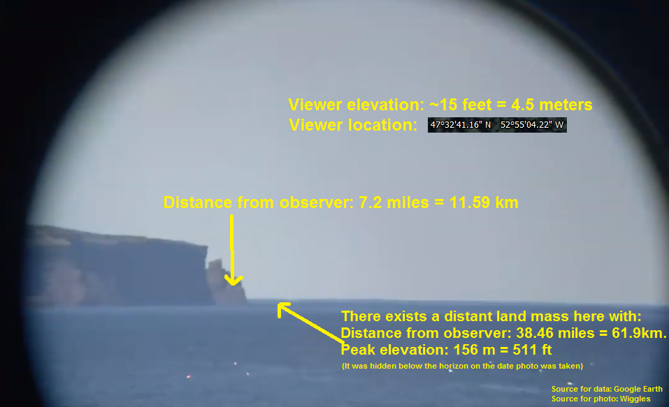
His point was: My camera in both images was 11.53km away from Bell Island. Assuming no refraction and viewer elevation of 2m implies the horizon should be 5.048km away. Clearly, in the lower image, the horizon appears to be behind Bell Island, implying the horizon is further than 11.53km away. So, we conclude 5.048km > 11.53km. What a blatant contradiction if ever there was one.
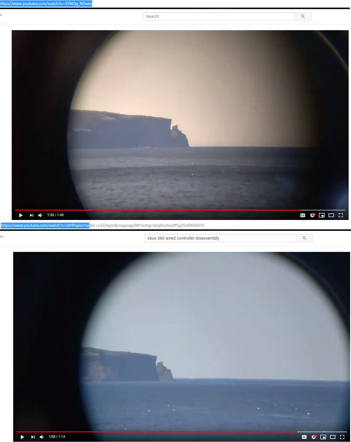
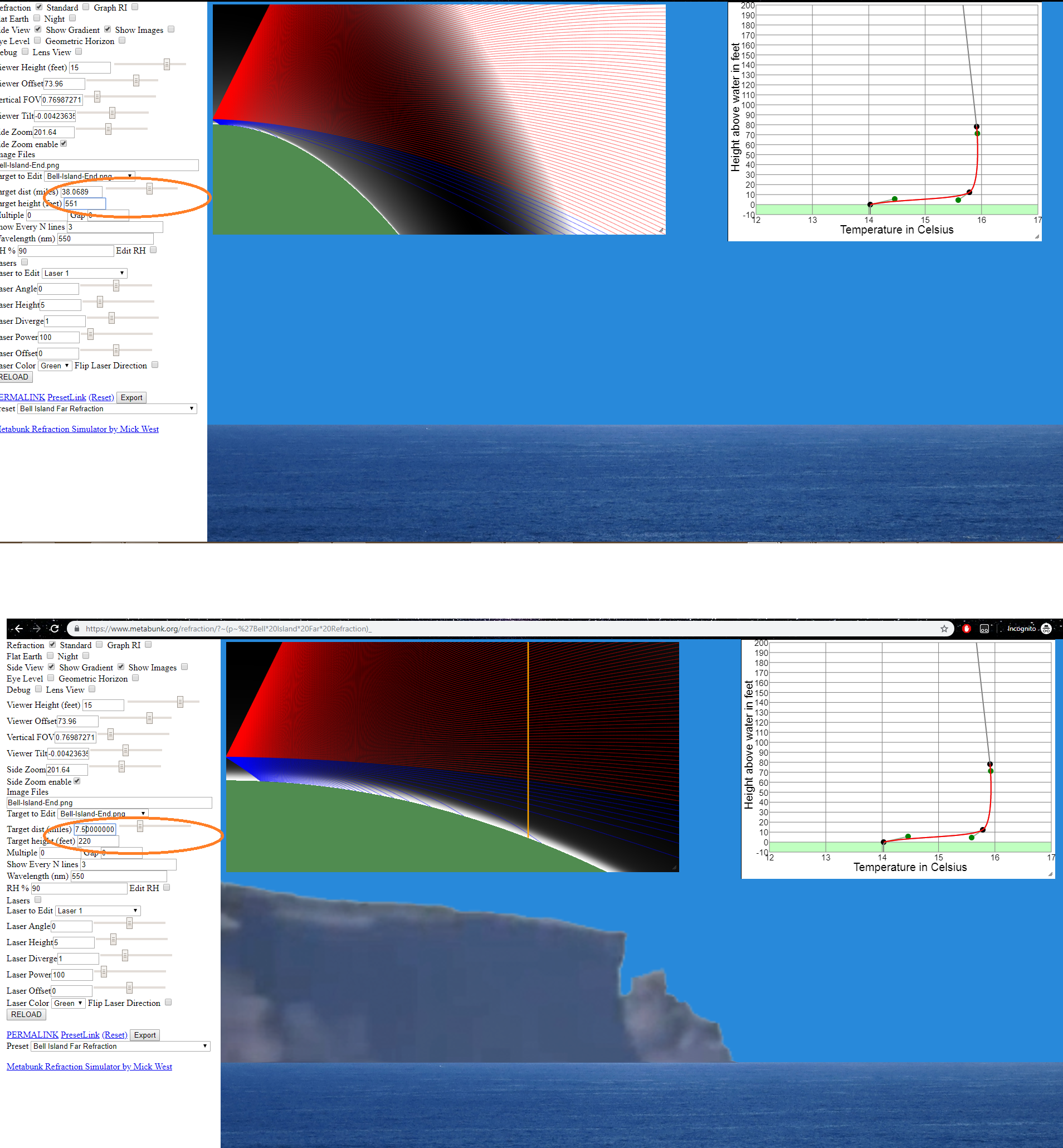
Even when applying the standard refraction correction by making R be 7/6 times greater, I would need to be at a viewing elevation of about 8 to 9 meters to push my horizon all the way as far as Bell Island. I can tell you that the height I had my camera at in both images was definitely a fair bit less than 8 meters. I'm almost certain I was sitting on the same rock as I took each photograph so that's a constant in both observations.

Unfortunately, the flat earther was so overjoyed that he claimed my observation proved earth is flat. At most, if refraction was completely predictable and obeyed the (7/6)R rule, I would have proved earth's radius cannot be 6371km. So it was kind of a letdown that the flat earther noticed this great example of refraction being unpredictable, yet his conclusion was not rigorous.

But yeah, here's some tangible evidence of refraction being a wild one.
 
Last edited by a moderator:
I tried to make another edit, but I just wanted to also point out the top image agrees with what is predicted when using the (7/6)R curve calculator.
 
Not to offend, but I really think your camera height is a decent bit higher than 2 meters. I took a screencap from your video, and based on measuring the height of the guy shown in pixels and the distance in pixels between his feet at the horizon (assuming that the horizon basically "rises to eye level" at very low altitudes), you're a minimum of 16 to 19.5 feet above that guy's feet. And to clarify, that range is calculated assuming that the guy is between 5 and 6 feet tall.

BellIslandFromBeach.PNG

Besides that, he's clearly above water level himself, which could easily add another few feet to your elevation. I absolutely agree that refraction is variable, and your footage shows that, but I also don't think that the situation is quite as extreme as either you or the flat earthers commenting on your video believe.

Just for some extra verification, could you provide the coordinates for your low position? I'm having some trouble finding the spot in Google Earth.

Thanks!
 
Last edited by a moderator:
Not to offend, but I really think your camera height is a decent bit higher than 2 meters. I took a screencap from your video, and based on measuring the height of the guy shown in pixels and the distance in pixels between his feet at the horizon (assuming that the horizon basically "rises to eye level" at very low altitudes), you're a minimum of 16 to 19.5 feet above that guy's feet. And to clarify, that range is calculated assuming that the guy is between 5 and 6 feet tall.

Besides that, he's clearly above water level himself, which could easily add another few feet to your elevation. I absolutely agree that refraction is variable, and your footage shows that, but I also don't think that the situation is quite as extreme as either you or the flat earthers commenting on your video believe.

Just for some extra verification, could you provide the coordinates for your low position? I'm having some trouble finding the spot in Google Earth.

Thanks!


I can provide that, no problem. I believe I'm exactly at where the red dot of the path line is there. I'm absolutely certain that I took the pictures from inside the orange oval, but I'm not sure which eroded spot i was sitting in. I'm 95% certain I was where the red dot is. I could go down there and physically measure the height above sea level since the sea is right there. I'd have to get a tripod and a level. 2 meters could be an underestimate. This is all I know.
 
Unless you've cut your footage really strangely, up to 0:14 appears to be one continuous shot from up in the parking lot, not down on the beach, which Google Earth thinks is 22 feet above sea level. If that's right, adding maybe 5 feet camera height gives you 27 feet above sea level, which puts the horizon right at about the distance to Bell Island. Maybe a little more or less dependent on weather conditions.

My point basically is that the footage in your video above appears to have not been shot from the beach, but rather from the parking lot, which drastically increases your elevation. From Google Earth:WigglesPosition2.PNG

From your video:

WigglesPositionVideo.PNG

Again, unless the video jump cuts from initial looking around in the parking lot (0:00-0:04) to zoomed in shooting from the beach (0:05-0:12) and cuts back to zooming out while still in the parking lot (0:13-0:14), then I don't see any significant issues. This footage was probably taken from somewhere in the ballpark of 27 feet elevation, and doesn't seem to buck "standard refraction" by very much.

As an aside, there could be an interesting analysis in figuring out the height of that rock pillar at 0:04 and seeing at what height the horizon intersects it. I'd be willing to bet it's under 27 feet up the rock face, which it would need to be for the horizon to "rise to eye level".
 
At the beginning of the video he's at the parking lot, but the shots he posted in the OP are from later on (note the times) and are much closer to the water, as can be seen at 1:01.
 
Regardless of the specifics of the refraction, the position of the horizon with respect to the land masses changes with height in your video, which wouldn’t happen on the flat earth, right?
 
Last edited by a moderator:

Bottom photo: That "horizon" to right of the island includes a superior mirage of the surface of the ocean beyond the island.

There is a kind of sandwich of dark, light, dark water. That top dark band is an inverted image of the surface of the ocean. The light blue band is where the "normal" image and the inverted image of the ocean blend together. The dark band below is a "normal" image of the ocean. That top band includes an inverted image of the island and headland as well. Look carefully. (It might be more complicated than that with alternating inverted and upright images.)

You don't see the raised horizon in front of the island and headland because they are blocking our view of the more distant ocean surface.

To make a potentially confusing problem clear...

One might think; "If that surface to the right of island is a superior mirage of the ocean surface, how come it ends at the edge of the island instead of blocking our view of the bottom of the island? It should go straight across the whole photo!"

Once again, we are seeing the surface of the ocean beyond the island, which would normally be beyond our horizon. But we can't see that more distant surface if the island is in front of it, non?
 
Last edited:
Here's a more extreme example of the same sort of thing taken through a more powerful telephoto lens. The dark band above is a superior mirage of the ocean. The light blue between is the sky.

On the left is something interesting. I think this is a motorboat, just beyond the normal horizon. There is an inverted image of the boat below an upright image. Of course there's an upright and inverted image of the ocean as well in this dark band but you can't see the difference.


So there are 3 images of the sailboat on the right. A "normal" image, an inverted image above that sitting on the inverted sea surface, and a partial upright mirage image above that. Fascinating stuff, and almost spooky.
 
Last edited:
I've retitled this thread "Refraction Variations Over Water to Bell Island", as "wildly unpredictable" is bit misleading. It's really only the refraction in a very narrow range (like around 1°) near the horizon that's complex.
 
I've added a preset to the refraction simulator
https://www.metabunk.org/refraction/?~(p~'Bell*20Island*20Far*20Refraction)_
Metabunk 2019-06-13 09-11-51.jpg

Note the profile of the island is NOT ACCURATE, as I just cropped it from one of the above photos.

This shows a 2°C temperature inversion over 30 feet rasing up the horizon beyond the island.
Viewer height here is 15 feet.

With standard refraction it looks like:
Metabunk 2019-06-13 09-15-44.jpg

No refraction:
Metabunk 2019-06-13 09-16-03.jpg

With flat Earth though you would always see the ocean beyond the island. So the fact that you can't in some images is a very good indication of the curve.
 
At the beginning of the video he's at the parking lot, but the shots he posted in the OP are from later on (note the times) and are much closer to the water, as can be seen at 1:01.
Ah, but of course. This is what I get for trying to analyze on too little sleep. :D 
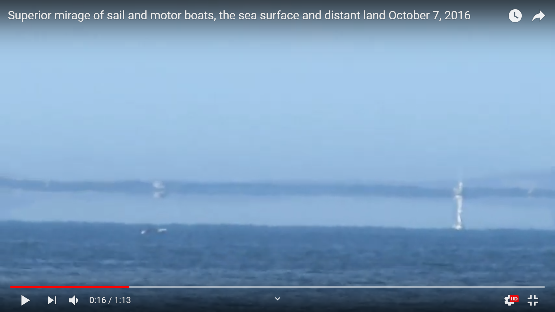
For a second attempt, at 1:00, you see a person standing at the water's edge (or very close to it).

WigglesBeachPhoto.PNG

I measure 87 pixels for said person's height, and 329 pixels from their feet to the horizon. They're bent over slightly, which obviously reduces height by some unknown amount. Assuming that from the top to bottom of their figure is around 5 feet, that puts Wiggles around 19 feet above the water level. For reference, Google Earth has that area being around 7-10 feet elevation, but I have trouble justifying that based on the video.

Doesn't match geometric globe predictions, as we've already established, but again, I don't think the situation is an extreme as initially thought.
 
I was back down there again today, and I can confirm 100% that the red dot at the end of the yellow line in the orange circle is where the two images were both taken from. I can also confirm that the rock *seems* to be more than 2 meters above sea level. I guess that sort of confirms I shouldn't even accept information given to me by flat earthers, even if the information is as simple as "2".

Also I'm appreciative that Mick has created a temperature profile preset for Bell Island, NL, Canada. I've made my own simple curve calculator, but a ray tracer, that's not so easy to make. It is apparently possible to work backwards and find a temperature/humidity profile to predict that the eye would see this on the standard globe model.
Thanks for sharing, something just wasn't sitting right with me about the 2 meter elevation. In fairness, that is what Google Earth seems to think, but it ought to be remembered that GE has its fair share of limitations regarding elevations, especially in less traveled areas.
 
I've added a preset to the refraction simulator
https://www.metabunk.org/refraction/?~(p~'Bell*20Island*20Far*20Refraction)_
Metabunk 2019-06-13 09-11-51.jpg

Note the profile of the island is NOT ACCURATE, as I just cropped it from one of the above photos.

This shows a 2°C temperature inversion over 30 feet rasing up the horizon beyond the island.
Viewer height here is 15 feet.

With standard refraction it looks like:
Metabunk 2019-06-13 09-15-44.jpg

No refraction:
Metabunk 2019-06-13 09-16-03.jpg

With flat Earth though you would always see the ocean beyond the island. So the fact that you can't in some images is a very good indication of the curve.

Hi Mick, one thing is not sitting quite right with me about this, and that is that according to this calculator, Bell Island would have to be 45 miles away to be fully disappeared. Consider Bell Island at 44 miles away which is on the threshold of disappearing behind the horizon in your ray tracing simulation: A closer, taller object should therefore be visible. However, there are in fact closer, taller objects to my OP observation point which are not visible in the OP lower pic. I've appeared to deduce a contradiction. Can you help me out with this?

I.e., is there a way to create a temperature profile that would predict the lower picture in the OP, that also allows a 39 mile distant, 511 foot high object (the NW Avalon tip) to be obscured?

For reference, here is me seeing NW Avalon tip, sitting on the exact same rock as I was in OP. The black on the extreme left is just the binoculars. The dark sliver to the right of that is Bell Island. The grey is the sky. The grainy stuff is the ocean. The smudgy bit between the sky and ocean is NW Avalon tip. I should be seeing this in the lower pic of my OP, according to the temperature profile you have given. But we are not seeing NW Avalon tip.


How do you explain this?
 
Last edited:
Exactly. I have no idea what we're looking at here. Sorry to seem grouchy, but your whole presentation is oppressively vague. You don't even tell us what country you're in.

I think you're standing in Labrador or Newfoundland. "Bell Island" is actually Baccalieu Island... I think. Give us a map with labels and directions. Where are you standing, what direction are you looking? What do you think you're seeing?
 
Last edited:
It's a good point: some coordinates and directions would be good. They are sort of visible in one of the screenshots, but something linked and/or cut-and-pasteable would be good.

I got him about here: 47.544652, -52.917926, looking north to Bell Island.

Let's cut some slack for new guys, huh? ;)

Wiggles - are you the Wiggles that used to show up on Nathan Oakley's 'debates'?
 
How do you know what you identify in your image is what you say it is?
I am extremely confident, since I'm familiar with the area and have looked across that stretch of ocean so many times. I also saw what is the NW tip of Avalon from the parking lot that day, and there are some photos here:
Source: https://www.youtube.com/watch?v=hiCgNRoDTwE&t=6s
. That outline on the horizon to the right of Bell Island (the large land mass on the left of the photos) could be a cloud, but it's shape perfectly matches the NW tip of Avalon when viewed from Topsail Bluff (ie, the large cliff next to the beach that is high enough to allow one to see NW Avalon tip over the curvature of the earth).

As I walked down the stairs, from the parking lot, the thing whose outline perfectly matched NW tip of Avalon became more and more obscured, until that object was not visible from the beach. I'm extremely confident it is NW tip of Avalon, but I apologize if I'm not able to provide all the data needed for that since I'm so familiar with the lay of the land here. As Rory said I'm a new guy haha, so I appreciate having some slack cut for me.

And yes Rory I'm the Wiggles who went on Nathan Oakley's "debates" a lot. I'm a very logical person haha, even though going there and expecting any result is completely illogical. I don't know, it was just addictive to go on the show for some horrid reason in my psychology.

But yeah in that video I linked I think there should be enough information to figure out these things with coordinates etc. IE here's a timestamp with the info:
Source: https://youtu.be/hiCgNRoDTwE?t=88
 
I apologize if I'm not able to provide all the data needed for that since I'm so familiar with the lay of the land here. As Rory said I'm a new guy haha, so I appreciate having some slack cut for me.

Hey Wiggles, I heard you a few times on Nathan Oakley's channel and I thought you did well.

As for posting on metabunk, the link policy is worth a read: in a nutshell (if I'm getting it right), people should be able to get all (or most of) the relevant information without needing to click on a link or watch a video. Then if they want to go deeper, they can follow it up and see what's going on.

I thought your OP was good enough; though GPS coordinates should have been included, so people could go to your location and check the distances and elevations for themselves.

Having heard you speak, I know you'll be all good with this stuff, it just takes a little getting used to - standards are higher, which is great, but it's also pretty unfamiliar compared to most of the internet. I've lost count of the number of posts I've had removed because they didn't meet the guidelines. But, c'est la vie. ;)

Anyway, have you tried to compare what you're seeing with Google Earth, or peakfinder, or this excellent German website, www.udeuschle.de/panoramas/makepanoramas.htm?
 
Last edited:
But yeah in that video I linked I think there should be enough information to figure out these things with coordinates etc.
I suggest you attempt a Google Earth zoomed photo overlay, as explained here:

Source: https://youtu.be/SoGcMwIar14?t=119

[Summary: Add a marker at the target location, move to camera location, add a transparent "photo", center on target, adjust the zoom to match your image, adjust the height if needed to see over water]
The save the Place, and post it here screenshots and with your conclusions.


I apologize since it seems I've not done a good job of communicating my point. First I want to point out that since you were on the Joe Rogan podcast, I have a huge amount of respect for you, given the high calibre of guests that go on that podcast. I think you very much represent the type of person that we should strive to be when talking to science-deniers, which there are too many of in the world today. You listen, sympathize, and try to help people out of the rabbit hole. I have huge respect for that endeavour. So whatever tone I come across with (since I appear to irritate people on the internet and I don't know why), please understand this is the underlying tone with which I am trying to convey my point.

Now, what I was trying to say earlier was that you were wrong(ish). You created a temperature profile to explain this observation (which I'll label as observation R13): .
In particular, the temperature profile you created:
https://www.metabunk.org/refraction/?~(p~'Bell*20Island*20Far*20Refraction)_
will generate R13 through the process of ray tracing.

However, using that temperature profile, if I edit the parameter "Target dist (miles)" to be 38.46, and if I edit the parameter "Target height (feet)" to be 511, the land mass remains visible. In this photo however, such a land mass is shown to be obscured by the ocean (ie, it is seen to be not seen if you know where it is). Therefore, the temperature profile you created cannot possibly have been what the atmosphere's profile was on the day observation R13 was made.

---

Now, the hilarious thing is, by some act of god, the temperature profile you created and posted last Thursday for Bell Island, Canada, must have been the actual temperature profile (within some %) last Thursday in Bell Island Canada, since what I saw last Thursday was predicted by it (as far as I checked by walking around the beach and varying my elevation and looking across the ocean). The photo in reply #15 of this thread (I will call that observation R14 using my scheme), was taken last Thursday and is what I saw. I want to emphasize that this is a rare atmospheric condition given the number of times I've been to this beach.

It is not a big deal that you were wrong(ish), because I could slightly modify the temperature profile you created, to be consistent with observation R13:

.

I just wanted to clarify this for everyone.
 
Last edited:
if I edit the parameter "Target dist (miles)" to be 38.46, and if I edit the parameter "Target height (feet)" to be 511, the land mass remains visible.
I get
upload_2019-6-17_0-3-33.png

which looks close enough to your photo to me. how you are supposed to differentiate a sliver of land from what maybe looks like water, I don't know.

ALTHOUGH I am using 511 because that is what you said (twice), but your "modification pic" says height 551.. so i'm not sure which is the correct height.
 
Hey Wiggles, I heard you a few times on Nathan Oakley's channel and I thought you did well.

As for posting on metabunk, the link policy is worth a read: in a nutshell (if I'm getting it right), people should be able to get all (or most of) the relevant information without needing to click on a link or watch a video. Then if they want to go deeper, they can follow it up and see what's going on.

I thought your OP was good enough; though GPS coordinates should have been included, so people could go to your location and check the distances and elevations for themselves.

Having heard you speak, I know you'll be all good with this stuff, it just takes a little getting used to - standards are higher, which is great, but it's also pretty unfamiliar compared to most of the internet. I've lost count of the number of posts I've had removed because they didn't meet the guidelines. But, c'est la vie. ;)

Anyway, have you tried to compare what you're seeing with Google Earth, or peakfinder, or this excellent German website, www.udeuschle.de/panoramas/makepanoramas.htm?

It's good to hear someone thought I did ok on Nathan's show, I'm tired of flat earthers just listening to Nathan hurl insults at me and thinking Nathan made some great point. "Wiggles is a a fundy zealot therefore earth is flat" seems to be Nathan's point. To many flat earthers it's a logically valid statement with a true antecedent. Eh, I give up.

That German website seems like a good tool. However, I've done so many observations across the stretch of ocean from Topsail Beach to Baccalieu Island, that the German panorama is just confirming what I already know.
 
I get
upload_2019-6-17_0-3-33.png

which looks close enough to your photo to me. how you are supposed to differentiate a sliver of land from what maybe looks like water, I don't know.

ALTHOUGH I am using 511 because that is what you said (twice), but your "modification pic" says height 551.. so i'm not sure which is the correct height.

The correct number is 511. The "modification" pic was made in a hurry. Ultimately 511=551 for this scenario though.

Yes, the temperature profile you cite there looks to be entirely consistent with observation R14 (which I linked in post 15 of this thread).
I could differentiate between the sliver of land and the water because I have good eyes. I'm nearsighted as hell, but despite the fact an optomotrist told me my eye lens looks like a football, my eyes really do a good job fighting off diffraction for stuff that's inches from my eyeball. When I worked as an electrical engineering co-op soldering those resistors that were half the size of a grain of rice, I'd often drop them on the board and lose them. But, I'd always find it after because I could really pick stuff apart with my eyes.
 
Yes, the temperature profile you cite there looks to be entirely consistent with observation R14
you said it's R13. I used your directions.
In particular, the temperature profile you created:
https://www.metabunk.org/refraction/?~(p~'Bell*20Island*20Far*20Refraction)_
will generate R13 through the process of ray tracing.

However, using that temperature profile, if I edit the parameter "Target dist (miles)" to be 38.46, and if I edit the parameter "Target height (feet)" to be 511, the land mass remains visible.


Ultimately 511=551 for this scenario though

:)
 
Back
Top