I do not trust this website with the other claims & "evidence" that has been debunked, but I have a friend that is spreading this information and I do not have the time to look up the validity of the evidence presented in the article.
I am mainly questioning the pictures the writer uses to show radar pulses and the videos such as this one showing round pockets of rain. They all seem like they could be editing tricks but a layout of these tricks would be helpful.
RADAR working at 750,000watts, your kitchen microwave working at only 1000!!
That's 750KW at 10% duty cycle?
90% of the time its zero watts and 10% of the time its at 750KW.
Then there is the conflation of HF, VHF, UHF and microwave, the conflation of microwave oven, cell phone and radar, the utter misunderstanding of what causes "heating" by radiative absorption and how wavelength dependant (not to be conflated with amplitude/power).
One other thing tweaks my curiousity though. Its well known that low level atmospheric heating occurs due to the mere fact of the presence of a city. Its all the buildings and pavement, and in winter, the radiative heat from buildings with central heat systems. If the effects he says his pictures show are due to atmospheric heating then I believe that city heat is more likely the culprit.
Microwaves are a form of electromagnetic radiation with wavelengths ranging from as long as one meter to as short as one millimeter, or equivalently, with frequencies between 300 MHz (0.3 GHz) and 300 GHz.
Microwaves are a form of electromagnetic radiation with wavelengths ranging from as long as one meter to as short as one millimeter, or equivalently, with frequencies between 300 MHz (0.3 GHz) and 300 GHz.
Yeah....that entire video is a prime example of "woo" at its highest form.
Although, as I've mentioned before....sometimes YouTube videos can be "trolling" with idiotic content, just to "get a rise" out of people.
AKA, the "Poe"....method? "Urge"? Not sure how to categorize this need....anyway, here is the 'Urban Dictionary' definition of a modern-day Internet "Poe": http://www.urbandictionary.com/define.php?term=Poe
In contrast to the power generation by the sources he cites, if those are even accurate, is in the range of 106W, maybe even 108W whereas a hurricane releases power in the range of 1012 - 1014W.
Even if the full power of these RF sources were to be absorbed in the vicinity of the transmitter, their contribution pales in comparsion to what a storm already has.
Heating of the atmosphere by Solar radiation dwarfs any heating that could be due to RF dielectric heating or microwave heating.
Solar panels are calibrated assuming 1000W/sq.meter of incoming solar radiation.
Take your typical residential blacktop driveway, say 4 meters by 6 meters, or 24 sq.meters. That's 24KW of solar radiation hitting it. Assume a conservative 1% conversion to heat by the blacktop, that's 240W. (by comparison some domestic lamp halogen light bulbs put out 300W, or that 240W is the equiv of 4 old style incadescent 60W light bulbs) Now multiply by all the paved 24 sq.meter areas of driveways and roadways and highways in a city. THAT'S heating!
Newest versions of NEXRAD WSR-88D have a peak power of 106W. So running wide open they are putting the power of 1000 microwave ovens. Truly that is nothing compared to the amount of heat in one little convective cloud much less the wattage of a thunderstorm. A microwave with very focused energy (as oppose to spread over the entire sky with a radius of hundreds of miles) might boil 8oz of water in a minute. So if you pointed the weather radar at kiddie pool 1 foot away you might be able to warm it (if it wasn't a wavelegth that would just bounce off of water as is weather radar). Compare that to the amount of water in a cloud and the latent heat of condensation when the vapor condenses into droplets to maket that cloud.
Furthermore the wavelength of the WSR-88D is one that bounces off of liquid water as opposed to passing through it and making it vibrate really fast as opposed to the longer wavelengths (communications) to which precipitation is transparent. Weather radar works because the wavelength of radio waves emitted scatters and the reciever interprets the reflected energy to determing what was out there, distance to the stuff, and velocity of the stuff relative to the radar stations.
Plus they don't transmit constantly. They send out blips and watch for the reflection and they do this while rotating to get a picture of the sky in all directions and at multiple angles. Every few minutes the radar scans a 360 degree sweep at several angles so that it can create an image of precipitation from near the ground to high up.
So the wavelength of the energy from a weather is not optimal for heating, even less so for communications frequencies. Plus, the energy from a weather radar is inadequate to do any significant heating since it is small in comparison to the amount of heat already driving the weather and because you are speading that energy out over 100s of cubic kilometers and not focusing it on something in a spot really close to the transmitter.
One other thing tweaks my curiousity though. Its well known that low level atmospheric heating occurs due to the mere fact of the presence of a city. Its all the buildings and pavement, and in winter, the radiative heat from buildings with central heat systems. If the effects he says his pictures show are due to atmospheric heating then I believe that city heat is more likely the culprit.
The video linked in the opening post isn’t detecting urban heat islands. And Dutchsinse isn’t altering the images. It is a quirk of Intellicasts composite RADAR display.
Intellicast attempts to depict precipitation type by color. Ran is green, yellow, orange, red. Mixed precipitation (sleet, freezing rain, rain mixed with wet snow) is depicted by shades of pink. Snow is shades of blue. The radar itself doesn’t measure the temperature. Intellicast integrates data from the RAWS (realtime automated weather station) network to guess at what is actually reaching the ground. RADAR just tells the intensity of the precip. Intellicast is using surface observations to guess at what the RADAR is detecting and coloring the map accordingly. Intellicast has gotten better at this since they introduced it in the late 1990s. Heck, they’ve encorporated digital elevation models into their algorithm such that they show different p-type in along ridges and valleys (hurricane/nor-easter Sandy produced an elevation dependent rain/snow event over WVA and western PA and the intellicast radar map was very interesting).
Those “warm spots” are around weather stations that are biased warm and are outliers. The RADAR is reporting incorrect p-type there and then extrapolating that to the surroundings.
In the following post (linked in the above Dutchsinse video in which he claims that radio transmitters and weather RADARs are heating the atmosphere by microwaving it) he insists that the transmitters are instead cooling: http://sincedutch.wordpress.com/2013/03/09/392013-antenna-produces-cooling-in-the-atmosphere-observed-real-time-on-radar/
3/9/2013 — Antenna produces cooling in the Atmosphere.. observed real-time on RADAR
Posted on March 9, 2013 by sincedutch
This lone spot stood out as odd — the only spot in a rain storm showing as “snow AND ice” at once over a stationary spot — the color coded precipitation, showing as becoming frozen, does NOT move with the rest of the storm as it passes by.
If you look to see what is at the center of the frozen spot — an antenna resides directly there. What are the chances?
Here is the antenna information: http://wireless2.fcc.gov/UlsApp/UlsSearch/license.jsp?licKey=13152
————
So Dutchsinse is simultaneously claiming that the antennas can produce either cooling or heating in the atmosphere directly over the transmitter. That doesn’t make much sense in light of his broader post linked at the beginning of this thread where he insists that all the microwave transmitters out there are accidentally heating the atmosphere like his GE Microwave Oven heats his Hot Pockets. It also makes no sense in that the antennas are not omnidirectional broadcasting up and out over top of themselves.
If you look to see what is at the center of the frozen spot — an antenna resides directly there. What are the chances?
The chances are pretty high since there is also a RAWS station there. The RADAR isn’t measuring a stationary spot of snow. The RADAR is detecting precipitation moving over that spot and the weather station is feeding incorrect temperature data to the RADAR so the RADAR thinks that the p-type there is different. The “frozen spot” doesn’t move because the thermometer on the ground doesn’t move.
Dutch might want to ask himself, how much energy would an antenna have to beam into the sky to heat 5 cubic kilometers of snow enough to melt it. He might also try to figure out how to heat snow with microwaves since dialelectric heating doesn’t work very well on solid water.
I personally would like to know how he hypothesizes that an “antenna produces cooling in the atmosphere” or how a radio wave that passes through air then heats air that does not contain any liquid water (he insists that radars are heating air in advance of weather too).
Can you link a “pulse” video of interest? Something on the geoengineering watch link makes my browser angry. We have some existing threads about Dutchsinse radar “pulses”.
and the videos such as this one showing round pockets of rain. They all seem like they could be editing tricks but a layout of these tricks would be helpful.
Some displays provided by commercial weather sites, like The Weather Channel, show precipitation types during the winter month : rain, snow, mixed precipitations (sleet and freezing rain). This is not an analysis of the radar data itself but a post-treatment done with other data sources, the primary being surface reports (METAR).[21]
Over the area covered by radar echoes, a program assigns a precipitation type according to the surface temperature and dew point reported at the underlying weather stations. Precipitation types reported by human operated stations and certain automatic ones (AWOS) will have higher weight.[22]Then the program does interpolations to produce an image with defined zones. These will include interpolation errors due to the calculation
So basically the radar isn’t detecting a statonary round pocket of rain. The radar is being fed incorrect data by a surface weather station and then coloring the display of precipitation accordingly.
As a cable head end tech I monitored(babysat) a dozen tvro satellite dish sites. There are two freq bands, Ku 12-18Ghz, and C 4G
-8Ghz
C band is well known among cable guys as being much less affected by weather whereas a Ku signal can completely disappear if there is heavy rain OR snow. I have been to sites where all Ku received signals were out but C band were all still on and the problem being a foot or more of snow in the 3 meter diameter dishes.
OTOH a C band dish full of snow in the morning, that then sees a rise in daytime temp to the point where the snow gets wet and then slides sees the signal drop out but only while the snow is moving. Perhaps it gets slightly scattered by water.
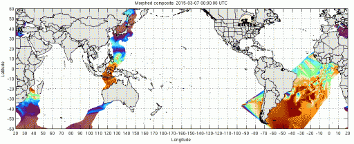
Another dutchsinse "microwave pulse" on MIMIC-TPW. Was going to ignore it but this vid has a lot of views.
This one appears to be due to bad or poorly calibrated data coming from one satellite. Earlier in the year there was a known issue with one of the satellites.
MIMIC-TPW (blended total precipitable water data) is described as:
The MIMIC-TPW product presents total precipitable water over the ocean, retrieved from SSMI and AMSR-E microwave sensors. The final product is an hourly composite of many swaths of TPW retrievals, advected to the required time using 1000-600 hPa winds from the GFS model.
A description of the known issue in March of 2015.
2015 Mar 10: Bear with us as we so some troubleshooting on the algorithm this week. We attempted to run the algorithm without F-15 SSMI data, which has been responsible for the glaring artifacts over the Atlantic that are appearing with increasing frequency. Unfortunately it looks like the artifacts will be here to stay over the next few weeks until we can attempt a new remedy.
The bad/missing data was responsible for the anomalies in the following animations from March 7 - 10:
Notice the progression of bad data swaths across the map. A similar yet more subtle effect can be seen in the animation covering a few days prior to dutch's "microwave pulse", from Aug. 27 - 30.
Which led to an artifact on Aug. 31/Sep. 1 as a result of the algorithm's inability to smoothly blend the bad data swaths:
And in the days after dutch's "pulse", the same progression of bad data swaths is still evident, and the atmospheric river associated with a broad low pressure circulation that passed New Zealand continued on uninterrupted, it certainly was not "destroyed" as dutch claims. Indeed, there appears to be no disruption to the general circulation pattern.
Dutch's "microwave pulse" is, as demonstrated again and again, nothing more than an algorithm choking on bad data.