How to Take a Photo of the Curve of the Horizon

in such a minimalistic fashion that literally anyone who can get their hands on a stick (and a peninsula, but the spirit level's not needed) can reproduce it.
If you have two opposite horizons, and adjust the stick so you can sight along it to see one horizon, and then sight in reverse and see the sky, that proves horizon drop, yes. Walter Bislin's site lets you calculate the drop angle you should be seeing at the height you'll be at, with correction for atmosphere; or Mick's own calculator here on metabunk.

A theodolite app on a smartphone might also work for this experiment.

How would you go about doing it with no equipment?
 
If you have two opposite horizons, and adjust the stick so you can sight along it to see one horizon
Looking through a straight tube works for this. It does not need to be long. You can use the tube from a disposable ballpoint pen.
 
If you have two opposite horizons, and adjust the stick so you can sight along it to see one horizon, and then sight in reverse and see the sky, that proves horizon drop, yes. Walter Bislin's site lets you calculate the drop angle you should be seeing at the height you'll be at, with correction for atmosphere; or Mick's own calculator here on metabunk.

A theodolite app on a smartphone might also work for this experiment.

How would you go about doing it with no equipment?
I'm hoping the viewing tower itself will have features, and if nothing quite lines up, there will be pebbles lying around. The more "anyone can do this, there's no excuse" I can make the experiment, the better. I even have friends with single-digit kids, so if it works I can repeat it with an audience to test whether it has the desired impact. Post social bubbles, of course.
 
If someone has such an opportunity again, it might be a fun one to try.

In this folder here, you can find lots of photos of the curve of the horizon as compared with a nearby straight edge:

https://drive.google.com/drive/u/2/folders/1lzXYY_HZ2xrlMPbG-4iDJu8f6QNsQEOo

Some are in this post here:

https://www.metabunk.org/threads/how-to-take-a-photo-of-the-curve-of-the-horizon.8859/post-229575

If I can contrive it, I will even try to do away with the stick, and make it a zero-equipment experiment. I'm not expecting clear weather to reliably have a clearly visible horizon for months, so not even I am holding my breath.

I tried the tube experiment a few times, but never had a clear view to both horizons - ironically, perhaps I was up too high (around 1500 feet, while CriticalThink's demonstrations were much closer to sea level).

My technique was to have to two tubes affixed side by side. When each one was aligned so it pointed at the horizon, it would be clear that, relative to one another, they were pointing down.

Would have worked nicely, I think, but I never got to give it a try (no longer live near that hill - nor have any more interest in flat earth experiments. :) )
 
If the earth were flat *and infinite in extent in all directions* there wouldn't be a visible horizon. There would be a theoretical horizon, but being at infinite distance would be attenuated to non-visibility (not to mention it would get in the way of the sun ducking below it).

However, none of the "circled by antarctica" flat earth models show something infinite in extent, so your argument does not address their currently favoured model.

I will confess that I generally find flat earth arguments to be so idiotic they're not even worth paying attention to - they've all been debunked a myriad times - but if we are going to waste time debunking them, we should do so with precision.

Moreover, they are circled by an impenetrable ice wall. I don't know how high that is, but certainly above sea level, so the FE horizon is actually a bit higher than we thought. :)
 
Moreover, they are circled by an impenetrable ice wall. I don't know how high that is, but certainly above sea level, so the FE horizon is actually a bit higher than we thought. :)
The height of that wall doesn't really matter much and won't be discernible with the naked eye.

With Flat Earth, it's usually better to use numbers.
A 3000ft (~1 Km) high wall, viewed from 1000 miles, subtends an angle of 0.03°. That's approximately the thickness of a fingernail held at arm's length.
New Zealand (and all other continents) is farther away from Antarctica than that, and the South Pole is barely closer than that from the nearest shore. (The highest peak in Antarctica is actually ~16000 feet. But that's not a wall. The edge of the ice, which is commonly shown by FEers to represent the wall, is much less high.)

You need surveyor's tools to measure that small of a difference.
DA-diags_D_a_1.4_continent_cross_section_ab.png

Source: https://discoveringantarctica.org.u...e/ice-land-and-sea/ice-sheets-and-glaciation/
 

Attachments

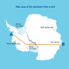
  • DA-diags_D_a_1.4_plan_view_ab_warmup.png
    DA-diags_D_a_1.4_plan_view_ab_warmup.png
    1.3 MB · Views: 334
Last edited:
Back
Top