Giant "distrail" across England

Trailspotter

Senior Member.
I was checking the satellite images of England on NASA Worldview for yesterday, May 16, 2015
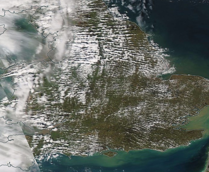
and noticed a rather unusual feature - a diagonal band devoid of clouds. It is particularly striking in the Aqua image at about 12:30 UTC:

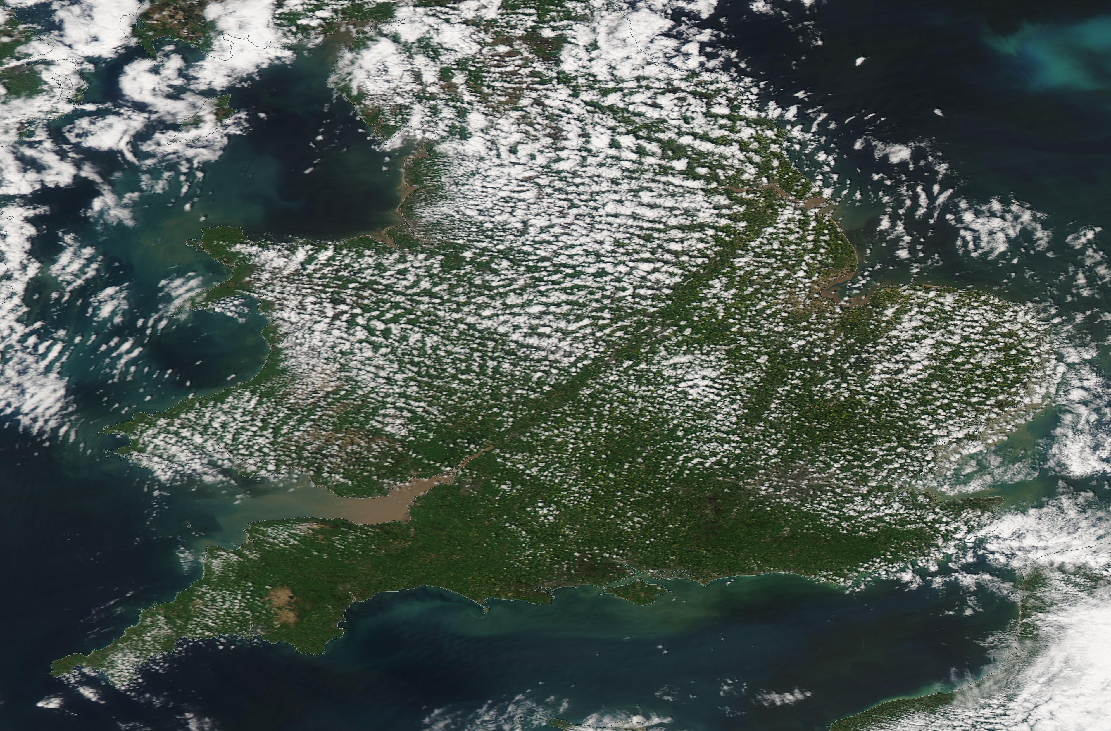
but it was also present in the Terra image at 10:45 UTC, nearly two hours earlier:


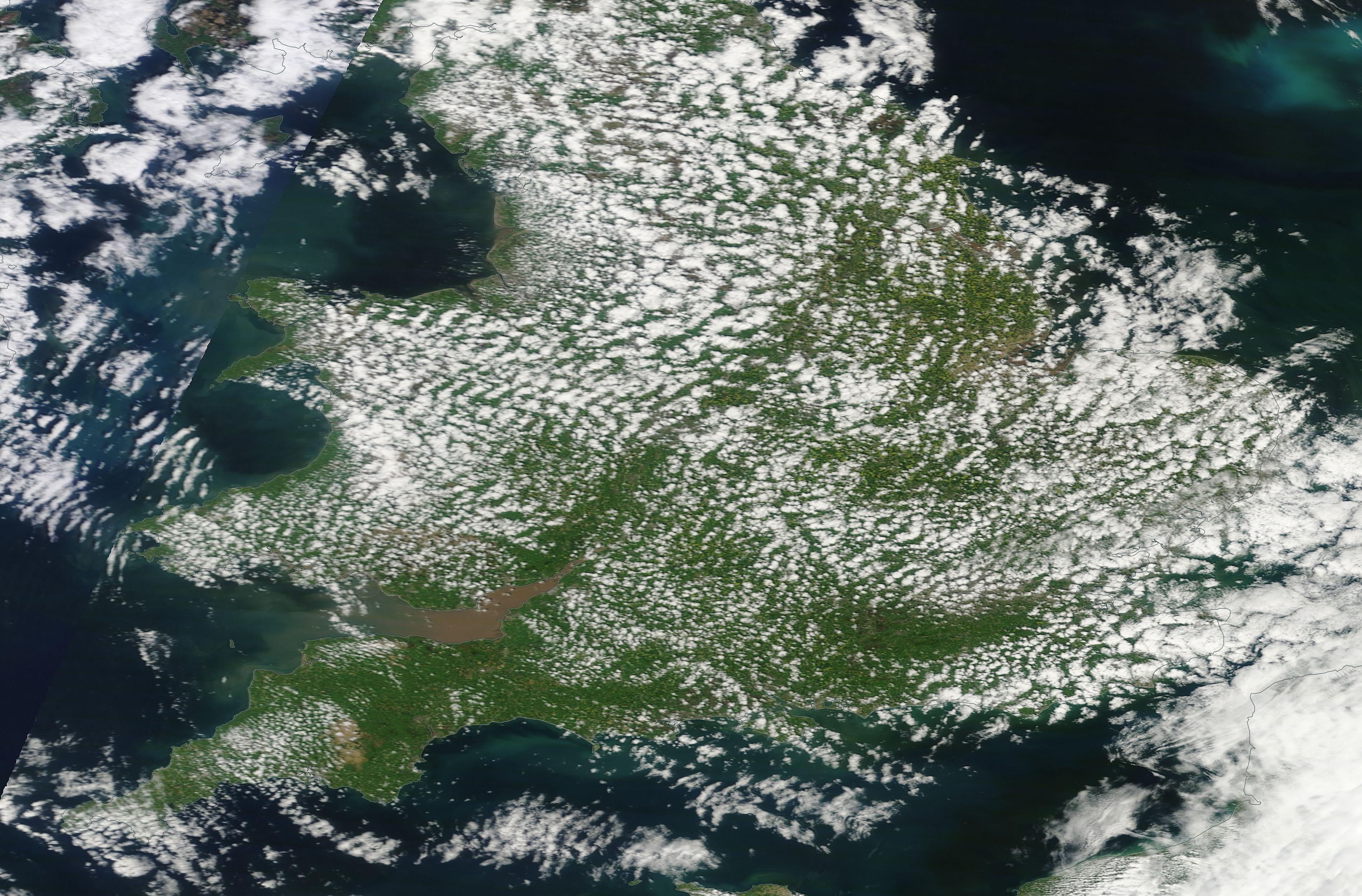
The most of the country was covered by ordinary small cumulus clouds that from below looked like these:
IMG_4520.JPG
This photo was taken above my place at the same time as the Aqua photo.

Is there a meteorological explanation to this phenomenon? Or is this a long-sought evidence of a secret cloud seeding program to send messages to alien spacecraft orbiting Earth?
:eek::confused:;):D
 
Last edited:
It shows up in the Weather Online satellite cloud 24 hr loop

Untitled.jpg
It travels across the country developing a bit north of Cardiff, and is gone before it reaches Norwich.

ETA - in this still it starts at Cardiff, passes slightly north of Birmingham and south of York.
 
Last edited:
Interesting how they seam to run from the Severn to the Humber, right along the traditional North / South divide. Looks like after the election even the weather is becoming polarised.

(edit) although the Humber / Severn line is also the rough line that divides the lowland south from the more hilly north, wonder if that could be a factor?

(edit - added link, quote and visuals)
http://www.sasi.group.shef.ac.uk/maps/nsdivide/


By county the North lies above the old counties of Gloucestershire, Warwickshire, Leicestershire and Lincolnshire and ‘nips’ only into parts of some of those counties. Most of each of those counties, and all the areas of England below them, are in the South.

By constituency the North includes and lies above the new parliamentary constituencies of the Forest of Dean on the north bank of the Severn; includes West and Mid Worcestershire, Redditch, Bromsgrove (and hence all of Birmingham), Meriden, Coventry South and North East, Warwickshire North, Nuneaton, Bosworth, Loughborough, Rushcliffe, Newark, Bassetlaw, Brigg and Goole, Scunthorpe, Cleethorpes, ending at Great Grimsby and the south bank of the Humber.

This map shows the line created by using parliamentary constituency borders. Click the image for a more detailed map.

It would be possible to go further and split some of these constituencies in half. It would be possible to identify enclaves and exclaves along the border, but this would suggest too much of a rigid line, and the border does move, especially when a new motorway is built or train line to London improved.
Content from External Source
 
Last edited:
Interesting how they seam to run from the Severn to the Humber, right along the traditional North / South divide. Looks like after the election even the weather is becoming polarised.

(edit) although the Humber / Severn line is also the rough line that divides the lowland south from the more hilly north, wonder if that could be a factor?

Having read @MikeC post and watched @Mick West video, I think that the weather aligned with the UK's topography to make this giant linear gap in clouds. Still, it would be interesting to learn how the geographical terrain can facilitate the cloud gap formation.
 
Back
Top