

SkyAugur
Active Member
A clip of a glowing "door" behind power lines went viral on X via Mario Nawfal (about 90K views) as "Brazil":
Source: https://x.com/MarioNawfal/status/2122413541072474332
The original is this Instagram reel from a barbershop in Campo do Brito, Sergipe, posted 9 Nov:
Source: https://www.instagram.com/reel/DfiXMI1RvnF/
A lot of replies say it's a window reflection. It isn't. Low clouds pass in front of it and dim it. A reflection would sit on top of the clouds.
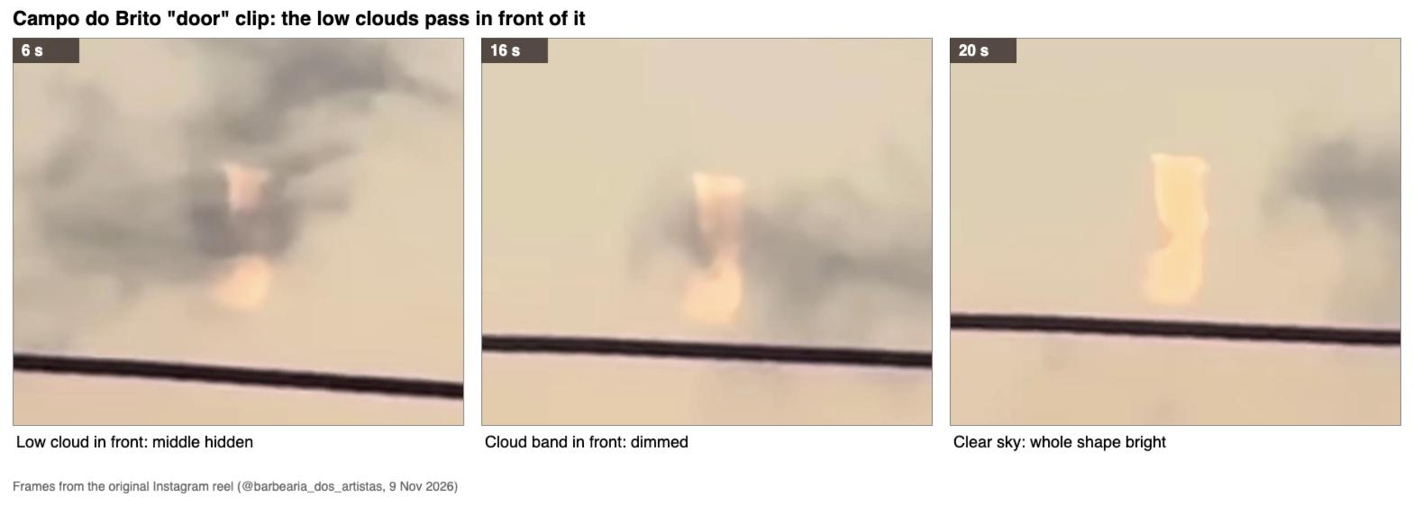
Jorge Uesu and Portal Vigília already looked at this and got the filmer's file info: iPhone 14 Pro Max, 17:36 local on 9 Nov.
https://vigilia.com.br/suposta-porta-luminosa-no-ceu-de-sergipe-intriga-moradores-o-que-poderia-ser/
Sunset there was 17:30. At 17:36 the low clouds were already in shadow, which is why they look grey. Anything at jet height was still in sunlight for about another 10 minutes.
The opening wide shot shows a hill line. It fits the terrain best looking south-southwest from the barbershop, which puts the door at about 212° and 6° above the horizon. Uesu's Google Earth overlay points the same way.
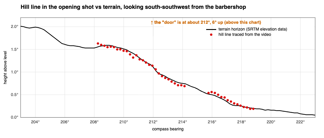
It doesn't move against the hills over 20 seconds, so it isn't a jet filmed live. It's also small: about half a degree tall. At jet height that is roughly 110 km away and 1 km tall.
For jets I used ADS-B Exchange history. N10LX passed at 17:13, but by 17:36 its trail would have been about 10° to the right of the door. The Azul A320 (AZU4277) was well off to the west. The one that does line up is Uesu's pick, the Citation PS-RNA at about 17:22. It has no ADS-B, so its path here is read off the Flightradar24 replay in his video and is approximate.
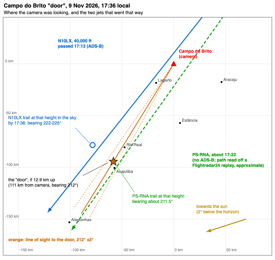
What doesn't fit neatly: the door is upright, and a level trail seen from 10 km off to the side should look tilted. The GFS model also has the air at 40,000 ft too dry for a long-lasting trail. GOES-19 shows no cirrus in that direction, so whatever it is, it's small and on its own.
So: a small patch of high ice cloud catching the sun after sunset, about 110 km SSW of the camera. A leftover bit of PS-RNA's contrail is the most likely source, but I can't prove which aircraft, and a small natural cirrus streak isn't ruled out. If anyone has the FR24 track for PS-RNA that evening, that would help.
Source: https://x.com/MarioNawfal/status/2122413541072474332
A bizarre rectangular shape was filmed drifting through the clouds, looking suspiciously like someone left a doorway open in the sky. No explanation for what we're looking at.
The original is this Instagram reel from a barbershop in Campo do Brito, Sergipe, posted 9 Nov:
Source: https://www.instagram.com/reel/DfiXMI1RvnF/
A lot of replies say it's a window reflection. It isn't. Low clouds pass in front of it and dim it. A reflection would sit on top of the clouds.
Jorge Uesu and Portal Vigília already looked at this and got the filmer's file info: iPhone 14 Pro Max, 17:36 local on 9 Nov.
https://vigilia.com.br/suposta-porta-luminosa-no-ceu-de-sergipe-intriga-moradores-o-que-poderia-ser/
(an aircraft contrail lit by the last rays of the sun)um rastro de condensação de aeronave iluminado pelos últimos raios do Sol
Sunset there was 17:30. At 17:36 the low clouds were already in shadow, which is why they look grey. Anything at jet height was still in sunlight for about another 10 minutes.
The opening wide shot shows a hill line. It fits the terrain best looking south-southwest from the barbershop, which puts the door at about 212° and 6° above the horizon. Uesu's Google Earth overlay points the same way.
It doesn't move against the hills over 20 seconds, so it isn't a jet filmed live. It's also small: about half a degree tall. At jet height that is roughly 110 km away and 1 km tall.
For jets I used ADS-B Exchange history. N10LX passed at 17:13, but by 17:36 its trail would have been about 10° to the right of the door. The Azul A320 (AZU4277) was well off to the west. The one that does line up is Uesu's pick, the Citation PS-RNA at about 17:22. It has no ADS-B, so its path here is read off the Flightradar24 replay in his video and is approximate.
What doesn't fit neatly: the door is upright, and a level trail seen from 10 km off to the side should look tilted. The GFS model also has the air at 40,000 ft too dry for a long-lasting trail. GOES-19 shows no cirrus in that direction, so whatever it is, it's small and on its own.
So: a small patch of high ice cloud catching the sun after sunset, about 110 km SSW of the camera. A leftover bit of PS-RNA's contrail is the most likely source, but I can't prove which aircraft, and a small natural cirrus streak isn't ruled out. If anyone has the FR24 track for PS-RNA that evening, that would help.


