Debunked: Plumes erupt from New Madrid Seismic Zone =2.9M quake follows. more coming?

With the earthquake today in Mexico, I expect Dutch will find a hit somewhere along that line of thunderstorms along the Sierra ridge.

If not that, I am sure he is already aware of the possibility of severe weather in the forecast in the south central U.S. I am sure there will be HAARP ring forecasts coming soon, followed by the obligatory pleading for "something in the tip jar".......
 
As my nephew returns to his seasonal job setting controlled burns,


Cue Dutchsinse,


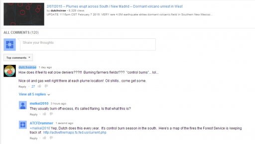
Current map of fires in the south

dutchplumes.jpg
 
crow.JPG

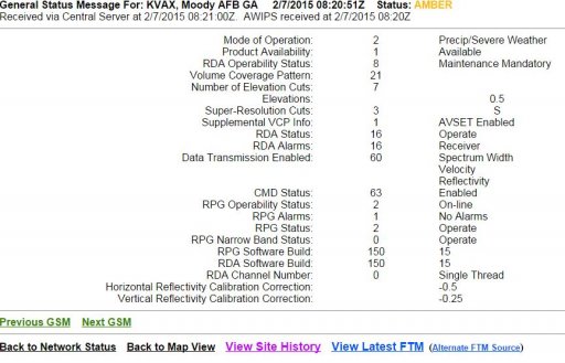
His buddy Tatoott posted a video of a "haarp ring" out of Moody AFB GA that Dutch seems to imply might be related to the "plumes" as well. Or certainly several of his viewers get that impression.


There WAS an anomaly on the Moody WSR-88D for a while that morning (2/7/15) but as is often the case, checking the status of that radar at that time reveals it was in a maintenance mandatory condition at the time of the anomaly. Not saying the maintenance condition is what caused the anomaly, but it certainly increases the likelihood that it did, especially since the problem was in the receiver.

But what would any of us know about any of these things, we are all just deniers.....


Moody.JPG
 
And here's a little taste of crowpie for dutchsinse...

Where in the vid did you actually match the coordinates of the "plumes" with the coordinates of these alleged oil and gas wells? All I saw you do was wave the cursor around and make a claim with no supporting evidence. I have evidence that at least one of those "plumes" in AL matches exactly with the time and location of a controlled burn in a section of the Talladega National Forest just west of Maplesville, AL. It is the beginning of controlled burn season throughout the southeast. In fact, all of your "plumes" look just like that controlled burn west of Maplesville.

http://www.al.com/news/birmingham/index.ssf/2015/02/talladega_national_forest_pres.html

https://www.google.com/maps/place/M...2!3m1!1s0x888ed8c5d45338f5:0x691f308bdfdf4df0
Content from External Source
I'm surprised your comment has lasted this long. You might have already done so, but I made an archive of it, https://archive.today/NRppY . My comment was removed with in an hour of my posting it yesterday.
cropped.jpg

I'd like to know what source Dutchsinse is using to identify the fracking sites. I'm not seeing any drilling near the 2 plumes he highlights in his video.

wells.jpg
http://www.drillingmaps.com/georgia.html#.VNjyUObF-CM
 
He's on my turf now, talking about plumes in Oregon. He really messed up this time because the "plumes" were in Deschutes County, an all seasons recreation hotspot on the eastern slopes of the Cascades with a population of over 150,000, which is why there are so many comments from locals about controlled burns.

Um We were having a controlled burn near black butte just outside of sisters, OR.
so sorry to debunk this video.
Content from External Source
Black butte had a major prescribed burn yesterday. Maybe that is the plume your looking at.
Content from External Source
These prescribed burns were on the east slopes of Lookout Mountain, right in my backyard here in La Pine. Granted, the weather conditions during some of these burns allowed the smoke to billow high into the atmosphere, looking like thunder heads at times ... but it aint no volcanic eruption that the government is keeping secret. I love the part in his video about "no doubt about it, there is a large volcanic eruption going on here and somebody needs to tell these people about it. Nobody else is going to tell them". This should tell you just how much credibility this guy has next time he cries wolf.
Content from External Source
ODFW is doing controlled burning right now. Come on I live about 15 miles from this. BS
Content from External Source
The first "plume" on the 29th was from a controlled burn just west of La Pine. I instantly recognized the area when I saw the satellite loop in the vid because we stayed in a vacation rental on the Little Deschutes river about ten miles due east of there between La Pine and Sunriver. The second "plume" was near Black Butte, a well known landmark with a tasty dark porter beer named after it (mmmmm Black Butte Porter). Both locations are near major highways and within view of Bend, OR a town of over 80,000.

http://www.ktvz.com/news/up-to-800-acres-due-for-burning-west-of-la-pine/32606152


POSTED: 6:02 PM PDT April 27, 2015

BEND, Ore. - If weather conditions remain favorable, up to 800 acres could be burned beginning as early as Tuesday on the east slope of Lookout Mountain in the Pringle Falls Experimental Forest west of La Pine, the Deschutes National Forest reported.

The experimental forest is about 25 miles southwest of Bend and 11 miles west of La Pine.

Ignitions are planned to begin Tuesday (4/28) and are expected to be completed by Thursday (4/30). Smoke will likely linger in the area for several weeks after ignition.
Content from External Source
http://www.ktvz.com/news/Prescribed-burn-planned-by-Black-Butte-Ranch/32652246


POSTED: 6:23 PM PDT April 29, 2015
UPDATED: 6:24 PM PDT April 29, 2015

BLACK BUTTE RANCH, Ore. - Given favorable weather conditions, Deschutes National Forest fuel specialists on the Sisters Ranger District plan to conduct a prescribed burn by Black Butte Ranch as early as Thursday (4/30) and continuing through Friday (5/1).

Up to 212 acres could be burned adjacent to Black Butte Ranch and ¼ mile south of Highway 20 in the Glaze Meadow area.

The prescribed fire is part of the Glaze Meadow Restoration Project, a project accomplished through close collaboration between the Forest Service, public and representatives from both the environmental and timber communities.
Content from External Source
From the description in dutch's vid...

The first half of this video was recorded early in the AM on April 30th (about 2am CDT), showing live visible satellite feeds of the plume in Oregon coming from a volcano on April 29th, the 2nd half of this video shows the additional plume event (again on live satellite feed) which occurred from Black Butte Volcano in Oregon later yesterday (April 30, 2015).

The new volcanic eruption story broke late in the afternoon April 30th, and is contained at the end of this video.
Content from External Source
The Axial Seamount volcano off the coast of OR/WA is suspected to have erupted on 4/24, a few days before those controlled burns. Dutch doesn't even locate the correct volcano on the map, Axial Seamount is the next volcano to the north of the one pegged by dutch. The eruption was successfully forecasted by a pair of scientists, one of whom is at Oregon State University here in Corvallis.

http://oregonstate.edu/ua/ncs/archives/2015/apr/researchers-think-axial-seamount-northwest-coast-erupting-–-right-schedule

http://www.pmel.noaa.gov/eoi/axial_blog.html

Among other mundane things seen on satellite like orographic clouds, dutchsinse claims smoke from controlled burns are volcanic plumes and ties them into his earthquake "forecasts". That says a lot about the skill in his so called forecasts. Whenever there is a spate of earthquakes, dutch starts spewing his nonsense about "massive movement" putting "pressure" here and there and naming 3/4ths of the worlds tectonic/volcanic hotspots and calling that a "forecast". He claims a "hit" when something inevitably happens in one or two of those named areas but ignores all the other areas that didn't get "hit" and ignores the activity in areas he didn't single out. His success rate is no better than chance... about what would be expected by putting a map in a monkey cage and watching where the pooh hits. But due to massive confirmation bias and censoring, his followers think he's a master earthquake forecaster. Funny that he can do that without any real scientific data like what comes from seismic stations, moment tensor solutions, ground motion sensors, satellite sensors that detect vertical and horizontal displacement. His lone source is Earthquake 3-D, and all that provides is location, magnitude and depth. Earthquake 3-D is a toy, not a source of serious scientific data.

One fact I'm sure is lost on them is the clustering that occurs in random series. Each individual tectonic/volcanic system has it's own timing, plates move at different speeds and directions in relation to each other and magma intrudes through the crust at different rates and volumes such that taken as a whole, events occur at random with the type of clustering described mathematically by a Poisson distribution. When global earthquake/volcanic activity seems to pick up it's due to the natural clustering of a random series, not because the events are interrelated. The same applies to those stretches when it's relative quiet.

http://www.wired.com/2012/12/what-does-randomness-look-like/

http://www.sciencedirect.com/science/article/pii/S037843711500028X

Edited to add link to video:

 
Last edited:
He's getting hammered in the comments...

Sorry Dutch, I live in Central Oregon and that plume you're talking about is prescribed fires on the Deschutes National Forest. It's very common this time of year
Content from External Source
I emailed the Z21 and they confirmed that it was scheduled slash burning done by the forest service, not steam vents.
Content from External Source
its fire season here in oregon and we been having fires around here. the air in my area has been full of smoke from them for the past couple weeks.
Those smoke plumes are from the fires.
and yes Oregon has tons of volcanoes. i live near a dormant one.
Content from External Source
You need to learn some basic geology of Oregon. I recommend Roadside Geology of Oregon, 2nd edition by Marli B. Miller published last October. Because frankly, you don't know what the hell you're talking about when it comes to Oregon geology. I live in Linn County. It's just west of that so called plume of yours, which was actually a controlled burn for forest management. There are lots of volcanoes in my state, but none are in active eruption. How to I know? I'D SEE IT FROM MY HOUSE. But hey, let me go check again... nope, no plumes in any direction but I clearly see the Three Sisters and Mount Jefferson. They still have pristine white snow caps. Get a clue man. Oh, and the flows at Lava Butte are some of the youngest in the state but they're still 7000 years old. The obsidian flow in Newberry crater is younger at about 1300 years old (page 245 of Roadside Geology of Oregon, 2nd edition.) I couldn't watch any more of this drivel.
Content from External Source
I find it amusing that this guy is so amazed by the number of volcanoes in Oregon. Proof he doesn't live here. Those of us who do, who have wandered lava fields our entire lives, who have hiked and skied these mountains, are fully aware that we could be annihilated if any of these giants awaken. Comes with the territory. Not surprised, just prepared.
Content from External Source
A lot of misinformation in this video. 1. Cinder cones (noted as Lava Butte, Black Butte, and all the others you zoomed on minus Bachelor and Newberry) are not DORMANT but extinct. Cinder cones never or rarely re-erupt. That's why there are so many of them is because the lava will just find the next weak area in the crust to break through.

Also Lava Butte is not 200-300 years old but more like 7,000 years old. More incorrect facts: While Bend is in the Pacific Northwest, it doesn't receive a lot of rainfall because it is east of the Cascade Range putting it in a high desert climate. Also your incorrect pronunciation of Nevada made me cringe.
Content from External Source
 
While a low pressure has been parked over the Pacific Northwest, dutch and his cohort tatoott have been watching a massive volcanic steam event across the entire west coast :eek:... otherwise known as diurnal orographic banner clouds and convective cloud development.

At 33:23 dutch sounds the alarm:


That vid has over 250,000 views. I fear for humanity.
 
It gets worse. His latest FB post turns a story about one trail temporarily closed in Yellowstone NP due to a boulder deposited by a rock slide blocking the path and one trail in Grand Teton NP closed/rerouted for the season as part of a seventeen million dollar renovation project... turns that mundane story into this:

In case you haven't heard..... hiking trails around Yellowstone, and into the Idaho / Wyoming border Teton Mountains have been closed to hikers for the nearterm future.

Officially blamed on "weather" and "rain".

Take it for what you will. That's the official story anyways...

Keep in mind the large volcanic steam plume events, and multiple earthquakes which occurred the past 3 days in the same general area.
http://dutchsinse.com/5242015-yellowstone-grand-teton-hiking-trails-closed-due-to-weather/
Content from External Source
No dutch, this is the official story...

http://news.yahoo.com/popular-yellowstone-grand-teton-trails-closed-now-001506273.html

In Yellowstone, the iconic Brink of the Lower Falls trail is closed in the Grand Canyon of the Yellowstone because of a mud and rock slide that deposited a 7-by-8-foot boulder on the route, effectively blocking the path.

In Grand Teton, the trail beyond Hidden Falls to Inspiration Point is closed and being rerouted so crews can replace bridges over Cascade Creek and rebuild the rocky ledge trails and steps that lead up to the popular Jenny Lake overlook.
Content from External Source
 
Just a reminder of the politeness policy:
https://www.metabunk.org/politeness-policy.t1224/
If someone feels that you are not being polite, or that you have in any way denigrated or belittled them, then they will start complaining about that instead of addressing your points, and will be far less likely to listen to you with an open mind. It also greatly affects the perception of more neutral readers, who respond similarly to the person being insulted.

I know Dutch is rather extreme case, but please don't veer into simple mocking. You can point out that he's wrong, and that he's very wrong, and consistently wrong, and possibly even discuss if he is being deliberate, or if he's a true believer. But please keep it polite.
 
Yet another "plume" vid of a controlled burn.


From the vid description:

A LOT of volcanic earthquake activity, but this is the first real steam plume event that is undeniable even to the skeptics who might have (in the past) tried to dismiss this as a "forest fire" or "thunderstorm" or "convection" or "regular clouds".....

In this case, its steaming / clouds coming directly from Sunset Craters on a clear day with NO other cloud cover nearby, no storms, no military explosions, no forest fires, and gone in a few hours.

All this leaves is a volcanic event of some kind as our only culprit for producing clouds on a clear day in the deserts of Arizona .. directly above the volcanoes in question.
Content from External Source
Well apparently dutch doesn't even try to look for fire info...

Fire managers are planning a maintenance prescribed burn beginning June 2, 2015 throughout the week near A-1 Mountain that will be very visible to Flagstaff residents. The A-1 Project burn consists of 645 acres and will likely be burned in blocks of about 200 acres each day from Tuesday, June 2, through Thursday, June 4, depending on conditions. The burn is located approximately six miles west of Flagstaff and a mile north of I-40 near A-1 Mountain. Winds are expected to take the smoke in a northeast direction, up and over the community and may impact I-40 south of the burn during the evening hours. Planned ignition time for this burn is 7:30 a.m. June 2, and smoke will be visible to those driving along I-40, as well as surrounding communities such as Flagstaff, Bellemont, Kachina Village, Baderville, Mountainnaire and Doney Park.
Content from External Source
http://inciweb.nwcg.gov/incident/4171/

Edited to add link to local Flagstaff news.

http://azdailysun.com/news/local/no...cle_5b1a12d9-2d15-57b5-b635-8e2970edafcb.html

That plume was within view of about 150,000 residents and two major highways yet not a peep on social media about volcanic activity.
 
Last edited:
but this is the first real steam plume event that is undeniable even to the skeptics who might have (in the past) tried to dismiss this as a "forest fire" or "thunderstorm" or "convection" or "regular clouds".....

In this case, its steaming / clouds coming directly from Sunset Craters on a clear day with NO other cloud cover nearby, no storms, no military explosions, no forest fires, and gone in a few hours.
Content from External Source
A clear day is the perfect time for a planned fire.

As with his plume claims over the last 4 years now, smoke that appears during the day and then dissipates is consistent with fire behavior, especially prescribe fire.

He insists that it must be volcanic in origin. That makes no sense at all. He has noted the diurnal nature of these plumes as evidence that the "plumes" are volcanic. However, he has watched enough volcanoes to know that they don't all pop off in the day and lay down at night. He's always got night videos of eruptions on his websites.

He has every reason to know that diurnal plumes (be they from fires or thunderstorms) are not consistent with volcanic activity. Yet he continues to repeat his plume claims even when there is hard evidence that he is incorrect; even when the fires are documented, when the thunderstorms are observed, etc... Make of that what you will.
 
So dutch elaborated on his theory a bit when criticizing the suggestion that it could be fires:

Fires at volcanoes in the desert all at the same time popping up across Mexico and Arizona..

Who is timing the fires to go off at the same time in Mexico and Arizona
Content from External Source
The sun. People burning during the time of day with the best transport winds and dispersion indices to make the fires burn well and carry the smoke up and away.

I'd say its smoke from rising magma coming out ... that's why it happens at the same time across a large area...
Content from External Source
Magma only rises during the day?

Can you demonstrate how and why this occurs?

Either that.. or a Mexican farmer is talking to a...and they're both on the phone planning their burns down to the minute..
Content from External Source
How do you determine that something was timed "down to the minute" from satellite images that refresh every 1/2 hour?

Aside from that, the fires aren't perfectly simultaneous and it is common fire behavior (both wild fires and planned fires) for the fires to peak in intensity during the hottest time of the day so smoke become noticeable on visible satellite imagery. So the plumes are consistent with fire and not geologic activity.

But there isn't anything to burn at two of the 3 locations... desert... no storms to cause fires.. and no roads to go out and start a fire
Content from External Source
1. There is stuff to burn. I can see that for myself as can anyone else with a little web browsing.

2. Don't need paved roads to go start fires when you have tractors, atvs, helicopters, or guys on foot walking along with a drip torch. Hell, we use airboats to start fires in the St. Johns Marsh during the dry season.
 
Yep, I saw plenty to burn while hiking around AZ and NM a few years ago, stuff like Mesquite trees, Creosote bush and Turpentine bush... BBQ cottontail anyone? :D

http://wc.pima.edu/Bfiero/tucsonecology/plants/plants_home.htm

There are two wildfires in southern AZ, one of them, the Guadalupe fire, encompasses about 2,000 acres. There were fires listed in Mexico as well.

http://inciweb.nwcg.gov/incident/article/4268/25002/

http://www.tucsonnewsnow.com/story/29228959/two-wildfires-burning-in-southern-arizona

http://www.tucsonnewsnow.com/story/29234788/nm-wildfire-continues-to-grow

last12_2015155_1000_fw_pts.png
 
You'd think after all the corrections about the OR one he'd know better...

Well, this thread started in 2012. The plumes he was claiming in the videos linked in the opening post to be volcanic were smoke from annual planned fires in a populated area. He was provided the burn plans from some of the forestry agencies doing the burns. He was provided with the reports of completed fires including dates of the burns, geographic coordinates, acres burned. He had eye witnesses that were his subscribers telling him that it was fires. Some of the fires were near enough to his house he could have easily day-tripped to the locations to attempt to verify his claims.

He did not correct himself. He did not attempt to verify his claims with his own eyes. He just deleted all the comments from the videos and left the videos up. Years later he is still behaving in the same manner. It is lucrative for him. I don't expect him to change.
 
Last edited:
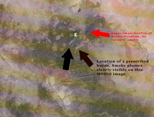
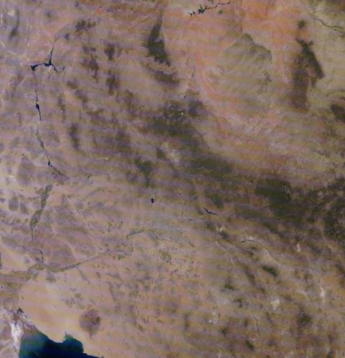
Thought I would check the MODIS satellite imagery for the period of time Dutch claims Sunset Mountain was spewing. MODIS is a higher resolving instrument than GOES. And sure enough, I found an image time stamped June 2nd, the day before the GOES image Dutchie claims shows a "steam" plume. Except in the MODIS imagery, you can clearly see the smoke plumes from 2 prescribed burns. These burns were referenced earlier in this thread and verified to be a 3 day planned event beginning June 2nd. They are nowhere near Sunset Mountain but they sure do resemble what Dutch is claiming to be a steam event in his post.

cropped fire image.jpg

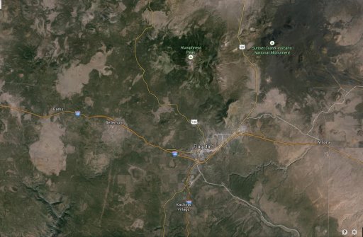
flag map.JPG

It should be fairly easy for anyone to locate the terrain features of both images, line them up, and determine exactly where those plumes were located. I used the 2 bare features on the far left of the lower image that almost look like fish. The community of Parks, AZ is seen in between the 2 terrain features I used for reference as seen in the lower image.

The full resolution MODIS image and the link to it:

http://activefiremaps.fs.fed.us/dat...15153180214-2015153181543_250m_az-000_143.jpg

http://activefiremaps.fs.fed.us/imagery.php?op=fire&passID=306491#

crefl1_A2015153180214-2015153181543_250m_az-000_143.jpg

The MODIS image I found for June 3rd does not show the fires burning....but then again it doesn't show any "steam" plumes either. MODIS imagery is not available as frequently as it is for GOES, but it does offer much better spatial resolution.
 
@scombrid Well yeah, it's clear that when pedantic folks like us give him information that contradicts his views it's ignored. I picked out the Oregon case in particular as one where he had people he didn't feel comfortable censoring calling him out. My impression was this was unusual.
 
The National Park Service personnel at the Sunset Crater National Monument were apparently inundated with calls from dutch's minions (after being warned to "get the word out") prompting the NPS at Sunset Crater to issue a press release to local media. Now dutch is spinning it into some sort of a massive cover up. Yeah, the entire population of Flagstaff and the occupants of all the vehicles that drove within site of Sunset Crater on two major highways are all in on the deception.

That GOES visible satellite image has a spatial resolution of 1km. The controlled burns were announced beforehand and set alight in blocks of 200 acres. Prevailing surface winds blew the smoke through a narrow gap between two mountains just north of Flagstaff and straight into Sunset Crater National Monument. The smoke plume likely did not spread out enough to be visible on the 1km resolution image until it was lifted and dispersed over a wider area by the terrain around Sunset Crater. Dutch also claims that the smoke shouldn't dissipate down wind (evaporate as he puts it) and compares it to a satellite image of a 14,000 acre wildfire in Colorado. Obviously smoke does eventually dissipate downwind and becomes less dense as it spreads out and mixes with surrounding clear air.

 
I have the MODIS imagery of his "plume"....I am considering starting a new thread for it since Dutch has made at LEAST 6 or 7 posts, a couple of which at least challenge someone to find and produce a high resolution image of that event. I'll post it soon. It's been a busy day with all the severe weather here in the mid central US, between chasing storms and working for that murderous, frequency blasting agency, the National Weather Service......
 
@scombrid Well yeah, it's clear that when pedantic folks like us give him information that contradicts his views it's ignored. I picked out the Oregon case in particular as one where he had people he didn't feel comfortable censoring calling him out. My impression was this was unusual.

It isn't common for his subscribers to correct him but it does happen on occasion. His first approach is to softly tell them that they are mistaken. Mostly he just glosses over corrections from his subscribers and focuses on baiting the debunkers (he calls us 'deniers') into a shouting match. When he fails to generate enough noise to drown out dissent from within his own congregation then the dissent just gets deleted as with the videos in the opening post of this thread in which he disappeared hundreds of comments.
 
I found some visual evidence of the prescribed burn.

The first image is from 5-2-15, the day before, showing the smoke blowing to the NE just south of Humphreys peak straight toward the Sunset Crater National Monument, pretty much as I described in a previous post. Humphreys peak is the snow capped mountain in the foreground, the cinder cones around Sunset Crater are just beyond the peak. The pic was taken from above I-40 looking toward the ENE. The fire is between the towns of Bellemont and Flagstaff.

A-1_fire_aerialview.jpg


There are videos of the prescribed burn that took place on 5-3-15, the day of dutch's "steam plume", at this link.

Dutch said the prescribed burn was over 50 miles away from Sunset Crater but it was actually more like 15 miles away and directly down up wind.

The fire was somewhere near the marker for A-1 on the map below. Note the location between the towns of Bellemont and Flagstaff which correspond to the above aerial photo.

Screenshot from 2015-06-08 19:50:04.png

The final nail would be ssfor27's MODIS imagery. I'll second the motion for the AZ plume posts be split into a new thread.
cheers
 
Last edited:
It's coming Solrey....I'm working the draft of the new thread right now. Probably will post it tomorrow sometime. I was just going to leave it alone and just accept it as another of Dutch's fantasy videos but then he just would NOT let it go. And then 2 things happened. First he challenged someone to find a higher resolution color image. Surprisingly, such an astute investigator is not aware that there is more orbiting our planet than just GOES. And secondly, he once again accused the National Weather Service of murder "by weather modification via frequency"...uh...what? (somehow even though frequency is just the number of times something happens in a set period of time) in one of his comments under the multitude of videos and posts he made about his "plume"....and that inspired me to look into myself.....
 
Next up, Owens Valey CA. Dutch is saying it's Long Valley Caldera I suppose to make his alleged "steaming event" sound legit.

Update on the West coast long valley caldera steaming event underway in East California....

Water Vapor feed shows the event as it is still ongoing... the live feed won't show it for more than a few hours.. so check it out while you can here below:
Content from External Source
https://www.facebook.com/Dutchsinse...6574443728320/955972531121838/?type=1&theater

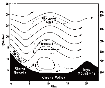
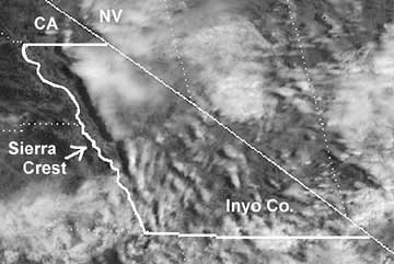
Got ya covered dutch, I captured a video of the visible satellite loop. What I see are clouds forming over Owens Valley with the passing of a disturbance moving in from the NW, which produces lee wave clouds along the way in the mountains just north of Owens Valley. Radiosonde data from Las Vegas indicates an inversion was likely present putting a cloud trapping atmospheric cap over the valley Makes me think that dutch did not record the loop on this one because it would be obvious it's just clouds.

 
There is a name for those stationary clouds over Owens Valley... Sierra Wave. As my video capture shows...

When a cold front approaches California from the northwest and the westerly airflow increases in speed over the Sierra crest, spectacular "stationary" clouds are usually seen over the leeward valleys. These are manifestations of a mountain lee wave, as it is known...
Content from External Source


http://esaudubon.org/about/leewave.php
 
Well, some things came up that required me to be out of town for a while and so accordingly I still did not get around to finishing that post refuting Dutch's Sunset Crater claim. Probably a bit late for that now as that fantasy's time has come and passed.

However, I am back in time to further debunk his latest Long Valley Caldera claim.

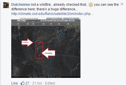
As you can see, Dutch claims you can "see the difference" between a wildfire and his alleged plume event. "Huge difference"....he states....and that "he already checked" for a wildfire. Really? Where did you look Michael?

clearly see.JPG


Because.....

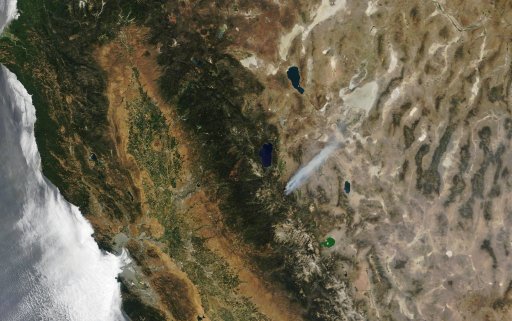
Your "plume" in today's MODIS image sure looks like smoke from a wildfire to me....

t1.15173.USA1.143.250m-62215sm.jpg

Link to the full image:


http://ge.ssec.wisc.edu/modis-today...lor/2015_06_22_173/t1.15173.USA1.143.250m.jpg

MODIS today home page.

http://ge.ssec.wisc.edu/modis-today/index.php

The same fire can be viewed for the previous days as well. Simply browse to the previous day by using the appropriate navigation tab near the top of the page.

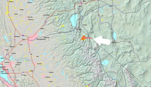
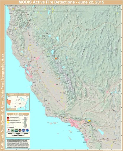
Lastly, the current fire detection maps provided by the US Forest Service confirm the Washington Fire in that exact area. Information that was pointed out to him on his Facebook page that he just simply ignores and allows his minions to charge forward with the attacks against anything that might refute his unquestionable knowledge.

cgb2015173_1300_ps.jpg

Full image and link to it:

cgb2015173_1300.jpg


http://activefiremaps.fs.fed.us/activefiremaps.php?sensor=modis&op=maps&rCode=cgb


know where to look.JPG

Do YOU know where to look Michael?
 
There are a couple of things happening here. The wildfire and the Sierra Wave over Owens Valley to the SSE of the fire. I'm prety sure dutch is claiming the Sierra Wave is the "steaming event", the cloud inside the rectangle on his image.
 
You're right Solrey. I hastily made that post in error. And apologies to Dutch. he correctly identified the wildfire. I was the one looking in the wrong spot. I saw that obvious fire in the MODIS imagery and immediately started writing. However, those MODIS images do show the Sierra Wave you mention pretty clearly on one of those days. Interesting phenomenon that I had not heard of before.
 
Each claim of his probably needs a separate debunk.

To date he has claimed that many different features from remote sensing products are "steaming plumes".

These features include smoke showing on visible satellite, diurnal pop-up thunderstorms on visible satellite, and certain returns on radar. Now we can add clouds in the lee of the Sierra Nevada mountains imaged with both visible and infrared imagery.

He often characterizes debunkers as trying to claim that it is all smoke.

Of course the broadest debunk is that the areas that he is claiming to be erupting are not uninhabited. It doesn't matter if it is smoke, thunderstorms, or wave clouds. There would be loads of eye-witnesses and accompanying video if it was steam or anything else sufficiently opaque and voluminous to show on visible satellite billowing out from the ground.
 
Back
Top