Debunked Claim: RH% too low for contrails

Balance

Senior Member.
Video shows;
Contrails in the sky above.
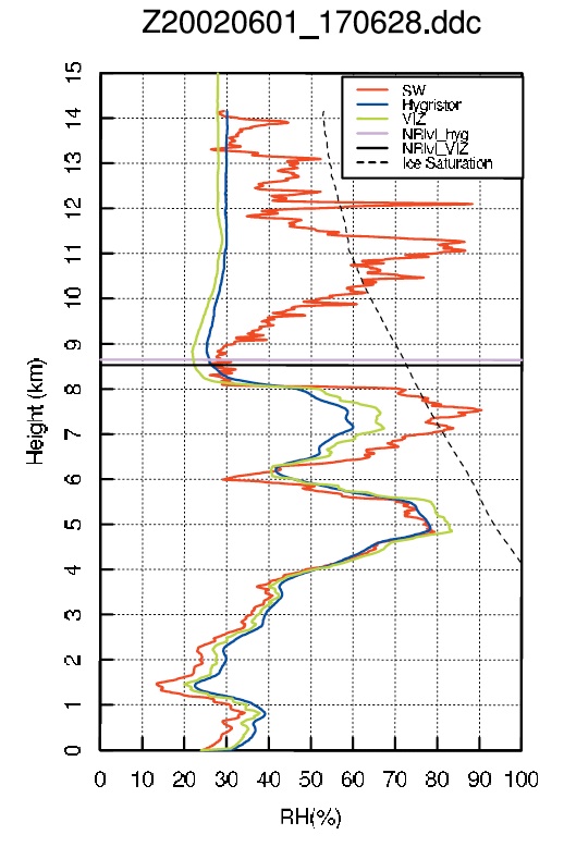
Weather data low 14RH% @10,000M
The uploader claims this proves he's not seeing contrails so concludes they're sprayed chemicals.


As we know, the oft used criteria for contrail formation persistence is a RH of ~65% so where's the disconnect here? I feel a layman's explanation would make an excellent exercise as this sort of "proof" is becoming more prevelant.
 
Last edited by a moderator:
Well he's 3 hours late for a start. 12z is 07:00 EST and he's filming at 10:00

Plus -50C is into the Always contrails area at 300 hPa
 
This is a possible candidate for the plane he couldn't identify, from the quick view in the video, I don't think he zoomed out far enough.

RonHines2.jpg
 
By the way, his statement that contrail formation requires 70% RH is wrong. There is no RH requirement for contrail formation. Only for contrail persistence.
 
This is a possible candidate for the plane he couldn't identify, from the quick view in the video, I don't think he zoomed out far enough.
is your time right? 15:07, the plane is about 9:45 based on his vid start at 9:42


add:
he's using "wx-now.com" for 'current weather'. I dont know what "wx-now" is since it covers the entire world, But CT news Friday night says Saturday was to be partly cloudy.
http://wxedge.com/2016/01/29/quiet-weekend-warm-start-to-february/


oops forgot my pic.. his 'current weather' is from an hour prior too according to his internet phone screen
mer.PNG
 
Last edited:
Why would he not use Brookhaven NY (KOKX), which is closer, or Albany NY (KALB) which is more upwind, for upper level RH. And yes a lot can happen in 3 hours, especially if the jet stream is close by, I don't know how to access days old upper level maps, so can't show that. With regards to contrails always with temp below -50 and above 300 HPA, that is most definitely not true, I have seen and identified many flights over this area that were completely contrail-less and at altitudes up to 41,000. Very hard to spot them with no contrail, FR24 is a big help, but even then, it helps when the sun is glinting off the fuselage.
I am also seeing people posting the contrails and then beside it a map of the RH at 30,000 ft confirming (in their mind) that the RH is too low for contrail formation thus it must be a chemtrail.
With regards to the surface weather report that he shows in the video, they are pretty much all automated now and I believe the cloud detector only goes as high as 20,000 ft, if there is nothing between the ground and that limit, then it will say the sky is clear. Also there can be cloud below it's limit that does not go over the sensor during the hour, thus it will report a clear sky.
 
Nobody should ever use a a single radiosonde sounding to predict, justify, or falsify a contrail observation. They are highly inaccurate when measuring RH at low temperatures, and almost certainly not a good representation of the conditions at the contrail.

Even if the soundings seem accurate, and predict contrails, that's more luck than anything. If you go and use those soundings to show that the conditions are right for contrails, then that basically validates the argument that trails are forming in other, impossible, conditions.

So unless you know the balloon went though the trail, and it had a chilled mirror hygrometer, then using that data is at best pointless, and at worst highly counterproductive.
 
Last edited:
Nobody should ever use a a single radiosonde sounding to predict, justify, or falsify a contrail observation. They are highly inaccurate when measuring RH at low temperatures, and almost certainly not a good representation of the conditions at the contrail.

Even if the soundings seem accurate, and predict contrails, that's more luck than anything. If you go and use those soundings to show that the conditions are right for contrails, then that basically validates the argument that trails are forming in other, impossible, conditions.

So unless you know the balloon went though the trail, and it had a chilled mirror hygrometer, then using that data is at best pointless, and at worst highly counterproductive.
Is there a way to find out what kind of hygrometer is used for a particular sounding?
 
Is there a way to find out what kind of hygrometer is used for a particular sounding?
There is a very good writeup on the two main types of hygrometers used worldwide, here:
http://onlinelibrary.wiley.com/doi/10.1029/2003GL016985/full
As Mick said, both have significant limitations in temps below -40, one being that it reads too dry, and two being that there is a time lag of 10 seconds at -20 to 80 seconds at -60, and that is for the better reference chilled mirror hygrometer. After reading through all the info, it was clear to me that RH measurements at temps below about -40 are not at all reliable and have a significant dry bias. Here are some excerpts:


Abstract
[1] This study evaluates performance of humidity sensors in two widely used operational radiosondes, Vaisala and Sippican (formally VIZ), in comparison with a research quality, and potentially more accurate, chilled mirror dew-point hygrometer named “Snow White”. A research radiosonde system carrying the Snow White (SW) hygrometer was deployed in the Oklahoma panhandle and at Dodge City, KS during the International H2O Project (IHOP_2002). A total of sixteen sondes were launched with either Vaisala RS80 or Sippican VIZ-B2 radiosondes on the same balloons. Comparisons of humidity data from the SW with Vaisala and Sippican data show that (a) Vaisala RS80-H agrees with the SW very well in the middle and lower troposphere, but has dry biases in the upper troposphere (UT), (b) Sippican carbon hygristor (CH) has time-lag errors throughout the troposphere and fails to respond to humidity changes in the UT, sometimes even in the middle troposphere, and (c) the SW can detect cirrus clouds near the tropopause and possibly estimate their ice water content (IWC). The failure of CH in the UT results in significant and artificial humidity shifts in radiosonde climate records at stations where a transition from VIZ to Vaisala radiosondes has occurred.
Content from External Source
[5] The SW chilled mirror hygrometer is a low cost dew-point sensor designed for radiosonde application. The SW's accuracy of the dew-point temperature measurement is <0.1 K. The SW's response time is negligible at +20°C, 10 s at −30°C, and 80 s at −60°C. Several studies have defined the SW's performance characteristics and accuracy, and show that it can be used as one of candidates for reference humidity measurements in the troposphere [e.g., Schmidlin, 2001; Fujiwara et al., 2003; Vomel et al., 2003]. These studies also indicate some limitations of the SW sensors: a lower detection limit of 3 to 6% RH, inaccurate measurements above these very dry layers and their inability to measure true supersaturation in the presence of cloud particles. The data used in this study did not encounter these very dry layers. As discussed in Section 5, we take advantage of the SW's ability to measure oversaturation to detect clouds and possibly estimate their liquid or ice water content.
Content from External Source
It also occurred to me, what if many aircraft were equipped with sensors that automatically sent wx data to ground stns or satellite every 15 mins or so, they could be more accurate and reliable and would provide a much higher resolution picture of most of the airmass in which planes fly. The sensor equipment could be provided by the NWS, including the cost of the downlink/uplink. A worldwide system such as this would negate the need for the launching of 1000 radiosondes every 6-12 hours, and greatly improve the quality of data, including over the oceans, where radiosondes do not go. Perhaps we will see this in the future when the technology becomes cheap enough, including the satellites that would relay this data, maybe it could just be an addon to the already existing system that relays aircraft operating parameters to the airline companies on a regular basis.
 
It also occurred to me, what if many aircraft were equipped with sensors that automatically sent wx data to ground stns or satellite every 15 mins or so, they could be more accurate and reliable and would provide a much higher resolution picture of most of the airmass in which planes fly. The sensor equipment could be provided by the NWS, including the cost of the downlink/uplink. A worldwide system such as this would negate the need for the launching of 1000 radiosondes every 6-12 hours, and greatly improve the quality of data, including over the oceans, where radiosondes do not go. Perhaps we will see this in the future when the technology becomes cheap enough, including the satellites that would relay this data, maybe it could just be an addon to the already existing system that relays aircraft operating parameters to the airline companies on a regular basis.

What about just using water vapour imagery from satellites?
 
What about just using water vapour imagery from satellites?
Satellites measure the total column water vapour in the atmosphere. It is very difficult to derive from that the water vapour content for a given atmospheric layer.
Because of the strong water vapor absorption line near 22 GHz, within the microwave range, we can use microwave radiometers to measure columnar (atmospheric total) water vapor.
Content from External Source
from: http://www.remss.com/measurements/atmospheric-water-vapor
 
It also occurred to me, what if many aircraft were equipped with sensors that automatically sent wx data to ground stns or satellite every 15 mins or so, they could be more accurate and reliable and would provide a much higher resolution picture of most of the airmass in which planes fly. The sensor equipment could be provided by the NWS, including the cost of the downlink/uplink. A worldwide system such as this would negate the need for the launching of 1000 radiosondes every 6-12 hours, and greatly improve the quality of data, including over the oceans, where radiosondes do not go. Perhaps we will see this in the future when the technology becomes cheap enough, including the satellites that would relay this data, maybe it could just be an addon to the already existing system that relays aircraft operating parameters to the airline companies on a regular basis.

Much of the weather data that goes into the forecasting models already comes from routine airline flights. Tens of thousands of such observations go into each six-hourly run of the NOAA's GFS model, for instance.

Only a small proportion of the aircraft supplying this data also provide water vapour measurements, but I believe this is changing. From a quick search:


•Nearly all participating AMDAR aircraft report temperature and wind data.

•Temperature is determined by the Total Air Temperature sensor, while ground relative winds are computed using an Inertial Navigation System or GPS.

•As of 2006, fewer than 10 percent of AMDAR aircraft measured water vapor, turbulence and icing.
Content from External Source
http://ocwws.weather.gov/afp/resources/AircraftWxObs-Jan07RAM.ppt


Also see this 2014 Bloomberg article. It states that fewer than 1% of commercial aircraft have the humidity sensors. http://www.bloomberg.com/news/artic...ecome-weathermen-as-sensors-upend-forecasting
 
As Mick said, both have significant limitations in temps below -40, one being that it reads too dry, and two being that there is a time lag of 10 seconds at -20 to 80 seconds at -60, and that is for the better reference chilled mirror hygrometer. After reading through all the info, it was clear to me that RH measurements at temps below about -40 are not at all reliable and have a significant dry bias.

It's not just that they have a dry bias, they also have a "No Response Level", which is an altitude above which they stop responding to changes in humidity and either return a fixed low value, or zero. Have a look at this graph of three types of RH meters with altitude. SW (red) is the accurate one. The other two have a dry bias and then stop working above 8,500m (~28,000 feet, just when you need them to be accurate).

 
It's not just that they have a dry bias, they also have a "No Response Level", which is an altitude above which they stop responding to changes in humidity and either return a fixed low value, or zero. Have a look at this graph of three types of RH meters with altitude. SW (red) is the accurate one. The other two have a dry bias and then stop working above 8,500m (~28,000 feet, just when you need them to be accurate).

Yes, I did see that in the web site I posted, just neglected to mention it.
 
The data has to be used with caution.
There is a known dry bias in the measured RH; the modest quality instrument is operating at the limit of its capability.
User needs to be aware that the data is times in UTC, not local time.
RH at a point is quite variable in time, and can vary markedly in the horizontal as well.

Modeled RH is a better indication, but that too has limitations.
 
Back
Top