Could The Gimbal Video Show an Atlas V Launch?

Leonardo Cuellar

Active Member
@Edward Current
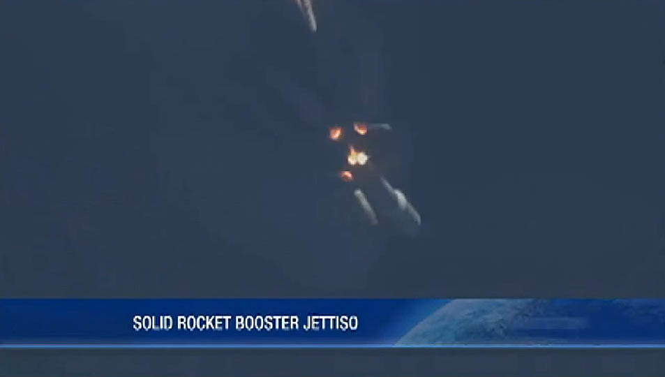
I found a coincidence that should be explored.
If we take the date of the video as taken between 20 and 21 January 2015 off Jacksonville, those same days the ULA launched an Atlas V rocket from Cape Canaveral carrying the MUOS-3 satellite. The military area of Jacksonville is bordering the Eastern Range and interestingly, the rocket had 6 SRBs. Do you think there is a possibility that the object in question is none other than the rocket and the objects that were observed by the radar the boosters ejected?
 
Last edited:
I think the Atlas Rocket thing is worth investigating. After the roll program has started, the rocket isn't traveling vertically. If the jet and the rocket were heading in the same direction and the rocket were very distant, there might not be much apparent relative movement.
 
Interesting theory, as it explains several things:
1. "There's a whole fleet of them" -- The SRBs (which could be going against the wind)
2. The large heat signature despite being >40 NM away (perhaps much farther than that — several different analyses, including my own, show that the bearing lines are virtually parallel, one person even going so far as to conjecture that the object is Venus)
3. A gradual increase in the blob's apparent size, if it were rolling in the direction of the jet

Furthermore, from the beginning to the end of the clip, the blob does appear to rise above the cloud horizon slightly — although the ATFLIR's downward-angle indicator remains fixed at 2°. What's the significance of the dot (I forget what it's called) moving up to the top of the screen? Does that indicate that the ATFLIR is actually tilting upward to 0°?
 
Last edited:
Do we actually know the date of the video? I have only seen it referred to as taken between 2014 and 2015.
 
Don't forget it any (rocket) has a ridiculously large heat profile. I can believe any theory NOT alien, but the Atlas theory sounds to me not correct.
 
Last edited:
Don't forget it any (rocket) has a ridiculously large heat profile.
Is that still true 700 miles away? It'd have to be 100× the heat of a similar signature 70 miles away, or 400× of something at 35 miles.
 
Is that still true 700 miles away? It'd have to be 100× the heat of a similar signature 70 miles away, or 400× of something at 35 miles.
Hmm, but it (the gimbal video) did not look like it was 700 miles away, right? 700 miles is quite a range..

But all in all, a rocket launch is so recognisable, I cannot image they mistake it for something else.
 
Last edited:
Thank You Guys.
Is that still true 700 miles away? It'd have to be 100× the heat of a similar signature 70 miles away, or 400× of something at 35 miles.
I relied on the estimated location stated in the NY Times article, which is off the coast of Jacksonville, much closer to Cape Canaveral
Do we actually know the date of the video? I have only seen it referred to as taken between 2014 and 2015.
@3db
According to this interview:
https://www.nytimes.com/2019/05/26/us/politics/ufo-sightings-navy-pilots.html
20 January 2015
Date of Launch 21 January 2015, 01:04 UTC
Honestly, more than the ATFLIR video I was intrigued by the description made by the pilots of a wedge formation that followed the largest object. Seeing this photo, the boosters are released simultaneously, hence a possible multiple radar track.

As @Edward Current rightly reported, a rocket's IR signature is very intense even many miles away.
 
But all in all, a rocket launch is so recognisable, I cannot image they mistake it for something else.
I get what you are saying, but is that not also true for another plane, or Venus, or pretty much any other mundane object?
 
I get what you are saying, but is that not also true for another plane, or Venus, or pretty much any other mundane object?
Yes. I also agree with your examples. Correctly, a judgement indeed should be based on facts and numbers. So my statement is an opinion only. :)
 
As a reference point, this thermal footage of a SpaceX rocket was taken by a NASA aircraft about 4 months before the gimbal video. Clearly, these are two different senor systems, but it shows what is possible.

Source: https://www.youtube.com/watch?v=_UFjK_CFKgA


Also, swear I used to be able to find a video of an F-35 tracking a SpaceX launch though IR from hundred of miles away. Image was detailed enough that I was suprised the footage was released, but i cannot find it anymore. Perhaps I am misremembering the plane or rocket type?
 
Not that one, footage I had in mind was much longer range, and very crisp, dont think there was any post production done on it.

To update, after watching the previous video a lot more, perhaps that is it. I thought I originally saw it as raw footage, but that video shows everything I remember it covering. Horizon break, boost phases, burn out, etc. Main point is that Northrop Grumman is claiming at the 1:13 mark that they can track rockets up to 800 miles out, at which point Faclon 9 engine turned off.
 
Last edited:
Does anyone remember the date the GIMBAL incident happened. Early 2015 from memory
Article:
The Department of Defense has authorized the release of three unclassified Navy videos, one taken in November 2004 and the other two in January 2015,

There's a wikipedia user who thinks it was on the 21st, but has not sourced this.
Article:
One was captured by a plane’s camera off the coast of Jacksonville, Fla., on Jan. 20, 2015. That footage, published previously but with little context, shows an object tilting like a spinning top moving against the wind. A pilot refers to a fleet of objects, but no imagery of a fleet was released. The second video was taken a few weeks later.

John Greenwald (The Black Vault) says it happened on the 21st, does anyone have a link to the source documents?
Article:
John Greenwald, author and curator of The Black Vault, the largest civilian archive of declassified government documents, originally reported the news. Greenwald requested information in August from the Navy regarding the content of the three popular videos purporting to show anomalous aerial objects.

In 2017 and 2018, three videos taken by Navy pilots from their aircraft made national news. In December 2017, The New York Times ran a story about Navy pilots who intercepted a strange object off the coast of San Diego on November 14th, 2004, and managed to shoot video of the object with their F-18’s gun camera. Another video, which we now know the date of due to Greenwald’s request for information, was taken on January 21st, 2015, shows another anomalous aerial vehicle rotating as pilots comment on how strange the object is over their communication system. Months later, DeLonge, through his organization, To the Stars Academy, released a third video showing an object quickly fly over the surface of the water. That video was also recorded on January 21st, 2015 raising speculation that the two videos shot that day show the same object.
 
Last edited:
It looks to me the Atlas-V launch is becoming a strong candidate for a positive identification of the Gimbal. Great job everyone (however it will pan out int he end) and especially @LeonardoCuellar who was the first to suggest it if I'm not mistaken! Shouldn't this deserve a new thread?
 
John Greenwald (The Black Vault) says it happened on the 21st, does anyone have a link to the source documents?
https://www.theblackvault.com/docum...ially-acknowledged-encounters-with-phenomena/

Article:
The Navy did not offer the exact designation numbers for the videos, but did reveal the dates for all three incidents. “[The] dates are 14 November 2004 for ‘FLIR1’ and 21 January 2015 for both ‘Gimbal’ and ‘GoFast.’”


The launch was on 20 Jan, 20:04 ET (21Jan, 01:04 UTC).
 
The launch was on 20 Jan, 20:04 ET (21Jan, 01:04 UTC).
We have a date discrepancy of one day. NYT says the video was shot on January 20, which would be the same day as the launch. Vice.com has it as January 21. Perhaps the latter date is based on UTC and someone forgot to translate it into EST.

If the location was indeed off Jacksonville, at that distance — let's guess 250 miles —a sightline over the horizon with an eye level of 25,000 feet starts at an altitude of only 2,115 feet. This pretty much eliminates the conjecture that the "fleet" are the SRBs. However, an Atlas V would have a much lower velocity that early in its launch, and with the SRBs firing, the heat signature would be much greater.

If we assume constant acceleration from launch until SRB jettison (time = 1:49, altitude = 27.4 NM), I get an acceleration of 26.2 ft/s^2. Then if we guess that the video starts when the Atlas V is at an altitude of 2,500 feet (t= ~14 s), and ends 34 seconds later (t= ~48s), then the video ends with the Atlas V at an altitude of ~30,000 feet. At 250 miles, that works out to an inclination of 1.2° over the course of the video.

Someone should check my math, but the ATFLIR's field of view at NAR zoom 2 is 0.35°, which seems to indicate that if this is an Atlas V launch, the clouds should be well out of the picture at the end.
 
Last edited:
I think the Atlas Rocket thing is worth investigating. After the roll program has started, the rocket isn't traveling vertically. If the jet and the rocket were heading in the same direction and the rocket were very distant, there might not be much apparent relative movement.
I recall seeing a Minotaur V launch back in 2013. What's interesting about the Minotaur V was that it was five stages, so you could follow it a lot easier as it staged. Not only did it have a phase where it appeared to have no motion, but the the last stage happened as the rocket passed over the horizon and was actually "lower" in the sky than the previous stage. It was a fantastic example of what a rocket's trajectory looked like from the ground when it is also traveling directly away from the observer.
 
So if the Gimbal and GoFast videos were taken on Jan 21st 2015. Then The Roosevelt which the jets took off from was participating in COMPTUEX. It's a wargame/excersize training thing . See below

https://news.usni.org/2015/01/12/upgraded-carrier-roosevelt-starts-pre-deployment-exercises

"
USS Theodore Roosevelt (CVN-71) shipped out on Jan. 8 to begin its Composite Training Unit Exercise (COMPTUEX) with the ship’s of its carrier strike group (CSG) to test the ships’ crew and equipment against a variety of threats.

“[COMPTUEX] is designed to replicate real world combat scenarios that can potentially present themselves to our strike group at any time during a deployment,” said Capt. Scott F. Robertson, commanding officer of guided missile cruiser USS Normandy (CG-60), in a statement from the service.
“We are going to experience real combat situations from all angles, there will be training evaluations from a hostile ship boarding, submarine attacks, and enemy ships or vessels trying impede their justice upon our strike group.”"

Here is more on what COMPTUEX is: https://en.wikipedia.org/wiki/Composite_Training_Unit_Exercise
 
Last edited:
Interesting theory, as it explains several things:
1. "There's a whole fleet of them" -- The SRBs (which could be going against the wind)
2. The large heat signature despite being >40 NM away (perhaps much farther than that — several different analyses, including my own, show that the bearing lines are virtually parallel, one person even going so far as to conjecture that the object is Venus)
3. A gradual increase in the blob's apparent size, if it were rolling in the direction of the jet

Furthermore, from the beginning to the end of the clip, the blob does appear to rise above the cloud horizon slightly — although the ATFLIR's downward-angle indicator remains fixed at 2°. What's the significance of the dot (I forget what it's called) moving up to the top of the screen? Does that indicate that the ATFLIR is actually tilting upward to 0°?
The "fleet of them" refers to the SA (situational awareness) display indicating radar tracks.
 
Whar is the range of that display?

From the sim docs
  1. Range Scale Option - The SA Range Scale (SCL) may be selected on the SA format by pressing the SCL/XX option. The range scale decrements on each selection, to 320, 160, 80, 40, 20, 10, and 5 nm ranges. Pressing SCL/320 will wrap around, causing the 5 nm range scale to be displayed. The SA range scale is the distance from the ownship symbol at the center of the display to the radius of the compass rose, therefore the total potential range coverage of the diameter of the rose is 640 nm. Another way to change the range scale is to move the TDC cursor to the top/bottom of the format and then back down/up. This will "bump" the range scale up or down by one scale setting each time it occurs.
However tracks from outside of the aircraft's own RADAR range would need to be provided across the MIDS/Link16 track sharing network, i.e. from someone else's RADAR.
 
The range scale decrements on each selection, to 320, 160, 80, 40, 20, 10, and 5 nm ranges.
Thank you!

So the "whole fleet of them" could have been no further than 320 nm (600 km / 370 miles) from the Roosevelt. And the Roosevelt would also know the approximate distance of that to the fighter jets?

Would the display indicate the altitude of the SRBs, if they were in view?
Is the display routinely recorded for later review?

It's 320NM from the JET to appear on the display, its top down, ownship centered, (it may be possible to change this but its not mentioned in the sim manuals.)

I.e. you could have a Jet with a RADAR range of 100NM fed a track from 320NM away by a ship/plane either closer to the target or with a much longer RADAR range.

If it's tracked on RADAR there is very likely an altitude available somewhere.

Generally I think both screens are recorded, I have mentioned a few times that having the other screen recording would help hugely in analysis but either they are too classified to be leaked or for some other reason they have never emerged.
 
At what altitude would that be?
https://spaceflight101.com/afspc-11/launch-profile/

It does depend on a few things, but generally quite early, in this profile at 3.9 seconds. It's not a fast turn, but rockets need way more horizontal velocity than vertical. A normal Atlas V is close to fully horizontal by the time it drops it's boosters and the second stage burn is almost all horizontal.

A crewed Atlas V for Starliner is a bit different, it uses a steeper ascent with a later and slower turn to eliminate a phase where a survivable abort is not possible, and carries the boosters farther after burnout - the two engine second stage makes up the horizontal velocity later. I can't find an ascent profile for Starliner, but the only such launch to date was December 20, 2019 for Starliner's Demo-1 flight so it wouldn't apply here anyway.
 
I.e. you could have a Jet with a RADAR range of 100NM fed a track from 320NM away by a ship/plane either closer to the target or with a much longer RADAR range
The range of a radar depends on the energy of the impulse and on the inverse-square law (in radars, since there is also a return impulse, the inverse of the fourth power is valid). Therefore only the largest objects are visible at great distances. The nominal range of a radar is that at which it can at most detect an object of one square meter, more or less the same as a stealth signature. That object to be detected at a great distance had to be large.
 
The range of a radar depends on the energy of the impulse and on the inverse-square law (in radars, since there is also a return impulse, the inverse of the fourth power is valid). Therefore only the largest objects are visible at great distances. The nominal range of a radar is that at which it can at most detect an object of one square meter, more or less the same as a stealth signature. That object to be detected at a great distance had to be large.

Yeah I know I am describing Link16 not saying anything about radar signatures.
 
Yeah I know I am describing Link16 not saying anything about radar signatures.
Yes, sorry. It wasn't a clarification to what you said correctly. I just wanted to clarify that the range of the radar depends on the size of the object. An Atlas V can be traced from AN/APG-79 even at 300 NM
 
It always confuses me with these videos, the thing is they are not using RADAR to have the ATFLIR track this object. I mean they don't HAVE to they could just point at the IR blob and autotrack but if they have a RADAR signature for anything (say a huge ATLAS rocket) then why not SLAVE? I guess they could have slaved then turned it off, there could be something else we just don't know about the videos.
 
that seems wrong
I understand 1/4r² where r is the range
Basically:
You start with a source radiating with power P.
It propagates a distance r, at that point the target receives a power proportional to P/(r**2).
The target reflects part of it (0<R<1), and it becomes a new radiating source with a power proportional to [RP / (r**2)]
Then it propagates back again a distance r, so the final power detected is proportional to [RP/(r**2)] / (r**2) = RP/(r**4)

More detailed: https://www.radartutorial.eu/01.basics/The Radar Range Equation.en.html
 
Back
Top