Oroville Watershed Weather Forecast, Lake Level and Inflow Calculations

Status
Not open for further replies.
It varies
https://water.usgs.gov/edu/watercyclerunoff.html
As with all aspects of the water cycle, the interaction between precipitation and surface runoff varies according to time and geography. Similar storms occurring in the Amazon jungle and in the desert Southwest of the United States will produce different surface-runoff effects. Surface runoff is affected by both meteorological factors and the physical geology and topography of the land. Only about a third of the precipitation that falls over land runs off into streams and rivers and is returned to the oceans. The other two-thirds is evaporated, transpired, or soaks (infiltrates) into groundwater. Surface runoff can also be diverted by humans for their own uses.
Content from External Source

As an amateur, I have to wonder about this, for the following reasons:

1. From what I've been reading, isn't the soil heavily saturated with water? Wouldn't that increase runoff?

2. It's February, and it's wet. How much evaporation will there be?

3. From what I've been reading, there is about 30 inches of water in the snowpack. The incoming storm is said to consist of tropical moisture, i.e. warm, and the snow has already been rained on, which makes it more likely to melt.

Only one-third of the rain goes into the reservoir? This seems pretty hopeful to me. I hope you are correct.
 
Last edited:
Only one-third of the rain goes into the reservoir? This seems pretty hopeful to me. I hope you are correct.

Well, no, I'm saying it varies. 30% is an average over the year, so it's going to be higher now. But it's certainly not going to be 100%.

I think DWR is going to be very careful with their calculations. They have a lot more information than we do about how the watershed will respond. There appears to be plenty of room.
 
No matter which way you slice it, that's a lot of forecast QPF falling on already very wet terrain in the direct vicinity of the Oroville Reservoir drainage basin in a short period of time.

I sure hope "they" have done their liquid water runoff calculations correctly.

QPF source : LINK

2-20 _ 3 Day QPF.jpg
 
Much of the precipitation will come as snow after today's warm rains. The high elevations where the precipitation amounts are high will not be adding much water to the inflows after today because snow levels will drop. You can see that a large amount of snow has accumulated at high elevations in the 108 hour accumulated snow forecast at Tropicaltidbits. That's why I think the calculations above are reasonable and that there will be a little spare capacity left at Oroville following today's heavy rains.


20Feb17z12prog108gfs_asnow_swus_19.png
 
Aligning the roughly representative Bucks Creek rainfall (pink) with inflow rates from the last storm (thin blue) and lake level (thick blue)
20170220-081705-4v8tf.jpg
Basically there's the a two day delay of 1" translating to approximately 50,000K cf, then there's another 2 day delay in the lake level peaking (this is highly dependent on outflow rates)

So the small increases (just an upwards trend)we are seeing right now are from the 17-19 feb rain event. There will be big spike in rainfall today, but (based on the above) that's not going to cause huge increases in inflow until around wednesday 22nd, and any peak will be on thursday or friday.
 
I'm pretty confident that the "bathtub" can handle the eventual inflow from the present weather event.

I just hope the main bathtub drain can safely handle the outflow without having to use the not completely repaired
back-up drain.

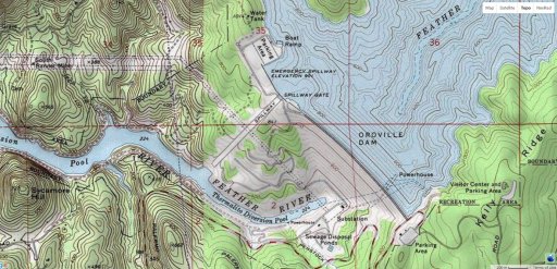
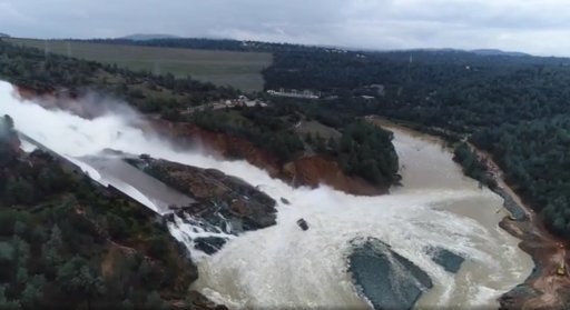
The main spillway, that tongue of land to the south east and the Thermalito Diversion Pool look like a real hot mess from the recent images I've seen.

001 USGS Topo.jpg

Drone footage from 02-19-17.jpg
 
What is the snow line predicted for the Monday-Tuesday storm?
http://forecast.weather.gov/product...TO&product=AFD&format=CI&version=1&glossary=1

Precip is on the upswing again the past
several hours as the lull has ended and the "big" storm is moving
in. Chico wind profiling radar has shown the snow level rising
above 7K ft.
Content from External Source
7,000 feet, not ideal.

Amusing they put "big" in quotes. It's big but short, maybe half the total precipitation of the last one.
 
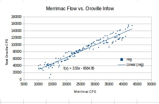
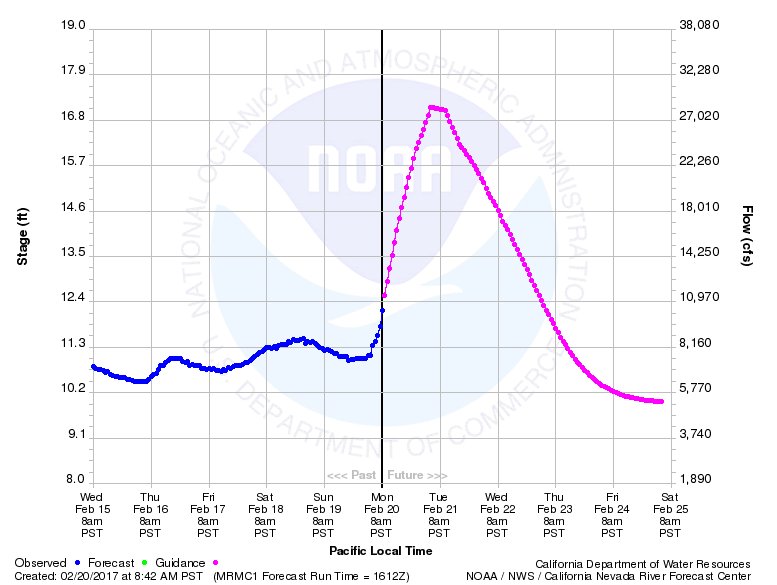
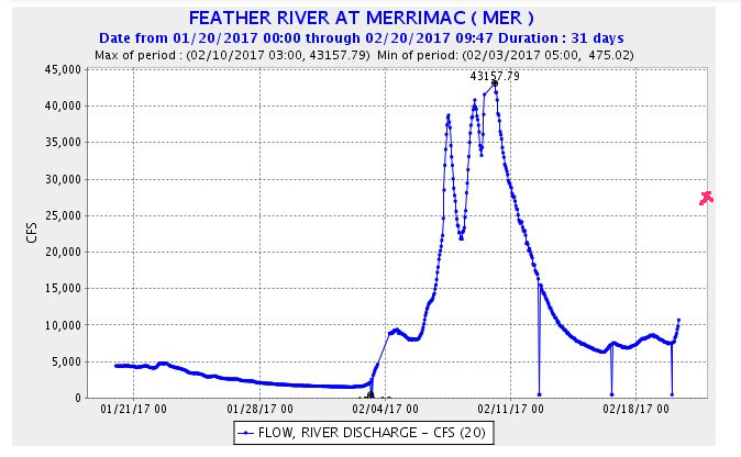
The inflow data for the dam can be closely correlated with the Merrimac (MIDDLE FORK FEATHER RIVER - MERRIMAC (MRMC1)) river stage sensor. This is of interest because the US NOAA California-Nevada River Forecast network provides a 5 day guidance flow for its river stage network. This means the guidance flow for Merrimac can be used to predict total inflow (within the correlation uncertainty).

The forward forecast for the Merrimac stage is predicted to peak at 28,000 cfs on near 6 AM Tuesday 2/21. The correlation supports a total Oroville inflow to peak at 108,000 cfs, near simultaneously. The predicted peak at Merrimac represents a significantly lower peak than the Feb 10th maximum (43,000 cfs)


Sources:
http://www.cnrfc.noaa.gov/graphicalRVF.php?id=MRMC1
http://cdec.water.ca.gov/histPlot/D...20/2017+00:00&end=02/20/2017+09:47&geom=small
 
Last edited:
The forward forecast for the Merrimac stage is predicted to peak at 28,000 cfs on near 6 AM Tuesday 2/21. The correlation supports a total Oroville inflow to peak at 108,000 cfs, near simultaneously.

Nice. And again supports the fact that this storm does not look like it will be a problem, so long as the main spillway can maintain similar outflows. They can keep it at 60K through the peak, and should be fine.

Time to start looking at the next storm? :)
 
The inflow data for the dam can be closely correlated with the Merrimac (MIDDLE FORK FEATHER RIVER - MERRIMAC (MRMC1)) river stage sensor.

The forward forecast for the Merrimac stage is predicted to peak at 28,000 cfs on near 6 AM Tuesday 2/21. The correlation supports a total Oroville inflow to peak at 108,000 cfs, near simultaneously.

Nice analysis; or at least as nice as the source data. But doesn't 28,000 at Merrimac calc to 92,000 at the reservoir, rather than 108,000?
 
Nice analysis; or at least as nice as the source data. But doesn't 28,000 at Merrimac calc to 92,000 at the reservoir, rather than 108,000?
Note the strict linear trend has the "bad outlier" problem (sensor failures, etc). A simple interpolation along the bounding line of the flow data chart yields a more defensible estimate.
 
Nice. And again supports the fact that this storm does not look like it will be a problem, so long as the main spillway can maintain similar outflows. They can keep it at 60K through the peak, and should be fine.

Time to start looking at the next storm? :)

The latest European model run merges the cut off low hanging out NE of Hawaii with the cold low dropping out of the Gulf of Alaska. If the ECMWF model verifies, the storm will be much warmer and wetter than the cold system the GFS is predicting. The GFS run would bring heavy rains further south to southern and central California. However, the ECMWF would bring warm heavy rains as far north as the Oroville watershed. I agree that this storm appears to be manageable but we have a long spring season ahead of us.

20Feb17ecmwf_mslp_uv850_swus_7.png
 
Between the current forecast:

upload_2017-2-20_12-47-30.png

and what's already fallen:

upload_2017-2-20_12-48-27.png

This storm has dwindled quite a bit since yesterday. I estimate a total 5-6 inches average over the basin.
 
The latest European model run merges the cut off low hanging out NE of Hawaii with the cold low dropping out of the Gulf of Alaska. If the ECMWF model verifies, the storm will be much warmer and wetter than the cold system the GFS is predicting. The GFS run would bring heavy rains further south to southern and central California. However, the ECMWF would bring warm heavy rains as far north as the Oroville watershed. I agree that this storm appears to be manageable but we have a long spring season ahead of us.

20Feb17ecmwf_mslp_uv850_swus_7.png

There is not a link to this image, and I don't know what the color scale is. Please try to use fewer acronyms and/or post the source where acronyms etc. can be determined by reader, thanks.
 
There is not a link to this image, and I don't know what the color scale is. Please try to use fewer acronyms and/or post the source where acronyms etc. can be determined by reader, thanks.

ECMWF and GFS are both major numerical weather models. The units are listed on the header; the lines are streamlines (each is the path taken by a parcel of air) at 850 HPa/mb (1013.25 HPa is mean sea level), while the shading is wind speed in kt at that level. The pressure centers are in HPa as well.

You're basically looking at the mid level jets, which are a major forcing mechanism in this type of system.

Edit: The image says tropicaltidbits.com in the header.
 
Last edited:
Sorry for the basic question.

What are the the actual mechanics for "measuring" the cubic feet per second (cfs) of the outflow and the inflow of the Oroville dam?

For the outflow I can imagine a paddle wheel type device that derives water speed multiplied by depth and width of gates, and be accurate.

But for inflow, how is that calculated? Seems like an impossible task with many assumptions built in, and could even be a back calculated Number based on lake depth..

Any experts?
 
What are the the actual mechanics for "measuring" the cubic feet per second (cfs) of the outflow and the inflow of the Oroville dam?

For the inflow it would seem they would measure the streamflow of major incoming rivers?
https://water.usgs.gov/edu/measureflow.html

Introduction to USGS Streamgaging
The U.S. Geological Survey (USGS) started its first streamgage in 1889 on the Rio Grande River in New Mexico to help determine if there was adequate water for irrigation purposes to encourage new development and western expansion. The USGS operates over 7,000 streamgages nationwide. These streamgages provide streamflow information for a wide variety of uses including flood prediction, water management and allocation, engineering design, research, operation of locks and dams, and recreational safety and enjoyment.

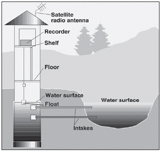
Streamgaging generally involves 3 steps. Click on the links below to explore each topic.

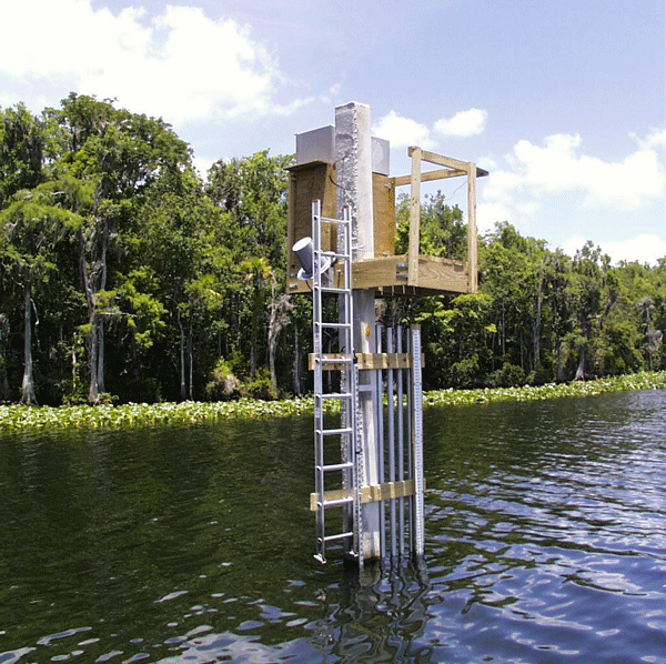
  1. Measuring stream stage—obtaining a continuous record of stage—the height of the water surface at a location along a stream or river
  2. The discharge measurement—obtaining periodic measurements of discharge (the quantity of water passing a location along a stream)
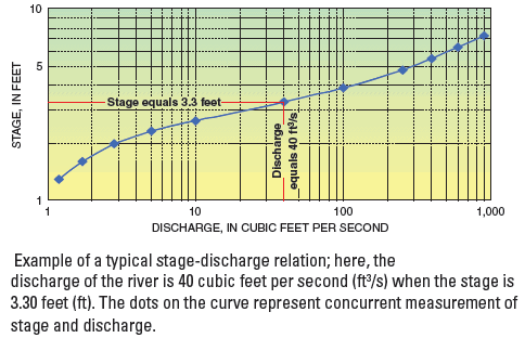
  3. The stage-discharge relation—defining the natural but often changing relation between the stage and discharge; using the stage-discharge relation to convert the continuously measured stage into estimates of streamflow or discharge
Streamflow summary
Streamgaging involves obtaining a continuous record of stage, making periodic discharge measurements, establishing and maintaining a relation between the stage and discharge, and applying the stage-discharge relation to the stage record to obtain a continuous record of discharge. The USGS has provided the Nation with consistent, reliable streamflow information for over 115 years. USGS streamflow information is critical for supporting water management, hazard management, environmental research, and infrastructure design. For more information on USGS streamgaging, go to the USGS Web site at http://water.usgs.gov. The National Streamflow Information Program offers more information on this topic., Go to the USGS Office of Surface Water Web site for more information on surface-water activities, and the USGS WaterWatch site gives you current streamflow conditions nationwide or in your area.
Content from External Source
Bunch of these.


Basically height of a river would translate into some CFS via some math
https://water.usgs.gov/edu/streamflow3.html

Most of the stage and streamflow information produced by the USGS is available in near real time through the National Water Information System (NWIS) World Wide Web site (https://waterdata.usgs.gov/nwis/). In addition to real-time streamgage data, the NWIS Web site also provides access to daily discharges and annual maximum discharges for the period of record for all active and discontinued streamgages operated by the USGS.


Content from External Source
I'm sure there's also some modifications they do to account for ungauged inflows.
 
Thanks. Further research shows that they use both a paddle wheel device and/or an acoustic Doppler measuring device. Article implies for streams the cfs measurement is performed by a person manually. I wonder how turbidity is accounted for with the Doppler systems.

Which brings up a pet peeve. Lies. Damn Lies. Statistics.

[Broken External Image]:http://rdcfeeds.redding.com/lakelevels/oro.cfm

Significant digits are important on BOTH sides of the decimal place. Showing inflow cfs data such as 67,546 cfs, is implying an accuracy that doesn't exist. I don't care if one number can have a higher accuracy, i.e. Outflow, compared to another with lowered accuracy, but assigning too high of an accuracy to a measurement makes me distrust any further analysis
 
Significant digits are important on BOTH sides of the decimal place. Showing inflow cfs data such as 67,546 cfs, is implying an accuracy that doesn't exist. I don't care if one number can have a higher accuracy, i.e. Outflow, compared to another with lowered accuracy, but assigning too high of an accuracy to a measurement makes me distrust awl further analysis

Just look at the graph.
upload_2017-2-20_17-7-8.png
Pretty obvious there's a lot of noise in the signal there. But the trendlines are good.
 
Looking in Google Earth, you can see what are probably the streamgages:

Mick, Very good eye finding those “tiny” points!

Those points you marked are inside the lake (are more technically lake branches than rivers); totally influenced by the lake level, so there is an additional difficulty to calculate the flow.

Those streamgages should have graphs like:

(streamgage level – dam level) vs lake branch flow cfs

Sure even more difficult because in some of those streamgages the flow in one lake branch affects the measure of the adjacent lake branch. So maybe the graphs mix together like:

(streamgage level A – dam level – (0.xxx streamgage level B + 0.xxx streamgage level C)) vs lake branch A flow cfs


Measure a river or lake level is easy, all the science came previous with all those engineers that worked maybe months to take many measures (scope; variation of the flow transversal area vs the deep of the flow; mechanics of fluids involved, laminarity, etc) and finally arrives to those “level” vs “flow” graphs.

And in any case will be estimate graphs and they will certainly change with time as the river suffers erosion/deposits, and the flow get also affected by vegetation that will be growing around (and also washed away). Lots of “difficult to measure variables” in play.
 
Yes, I'm sure there's a fairly complex model, with lots of inputs, that they use to calculate the inflow. They probably have refined it based on observed outflows, less minor calculated evaporation losses.
 
I've spent more time tthan I should've on this, but it really captivated me after that near-miss. I come away thinking that there's far less immediate danger to the dam than I had feared. Looks like net inflow will peak at maybe 40,000 cfs, which won't be even close to enough to refill that big dog.
 
20170220-181805-poie7.jpg
88.9K now, which seems a bit high to be stopping at 110K, as it's still raining fairly heavily.

The prediction is that inflow will peak at 105,000 cfs, with outflows at 60,000 cfs. From what I have been reading, there is a LOT of room for error. I say this as someone who has been pretty worried. I thank this site, among four or five sites, for the continuing updates. I am only an amateur, but not an idiot, and no one's ax-grinder. There are plenty of questions left about the whole system, and about what the spring will bring, and about the (lack of) competence and maintenance.

But it looks like (crossing fingers) that we will not be looking at a repeat of the weekend before last in the coming week. If that winds up being true, it's very good news, to put it mildly.
 
The inflow data for the dam can be closely correlated with the Merrimac (MIDDLE FORK FEATHER RIVER - MERRIMAC (MRMC1)) river stage sensor. This is of interest because the US NOAA California-Nevada River Forecast network provides a 5 day guidance flow for its river stage network. This means the guidance flow for Merrimac can be used to predict total inflow (within the correlation uncertainty).

The forward forecast for the Merrimac stage is predicted to peak at 28,000 cfs on near 6 AM Tuesday 2/21. The correlation supports a total Oroville inflow to peak at 108,000 cfs, near simultaneously. The predicted peak at Merrimac represents a significantly lower peak than the Feb 10th maximum (43,000 cfs)


Sources:
staid=MER&sensor_no=20&duration=H&start=01/20/2017+00:00&end=02/20/2017+09:47&geom=small

What a difference 10 hours makes.

MERRIMAC FEB 20 20-02-2017 11-13-32 PM.jpg

EDIT
I based the interval on the time of your posting as the Generated date and time was not showing.
 
I foolishly read something into a single reading, just after noting how much noise there was in the inflow estimate. Now four hours later the inflows are essentially unchanged, but more likely reflecting a more gradual upward trend.

upload_2017-2-20_22-12-48.png
 
Looking in Google Earth, you can see what are probably the streamgages:
20170220-163729-fqyam.jpg

20170220-164141-2f44i.jpg

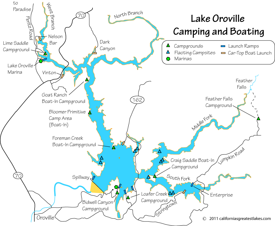
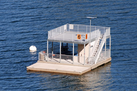
I'm believe that you found the floating campsites that are on lake Oroville. Cool concept actually. They may have some floating outhouses, but I've never personally seen one on Oroville. I've seen them on Shasta.

Just from the patterns of the data I think that the inflow is calculated using elevation data and the outflow that they can measure directly. There has been unusual noise in the data from the ORO sensors. Not really sure why it is happening, but it's sure been mentioned here several times. In my many years of amateur reading of lake level senors via the internet one pattern has always held true. The inflows just don't jump around hour to hour like the CDEC ORO sensor data has been. Large flows trend up and down, but not thousands of CFS up or down per hour. Sure it changes quick in large rain event, just not up and down in a noisy fashion.

I'd guess that the lake elevation is via a pressure gauge associated with the powerhouse. Just the physical size of a traditional water level gauge would be a challenge. I just don't see how to get readings from full to nearly empty.


Last edited:
I'm believe that you found the floating campsites that are on lake Oroville. Cool concept actually. They may have some floating outhouses, but I've never personally seen one on Oroville. I've seen them on Shasta.

Just from the patterns of the data I think that the inflow is calculated using elevation data and the outflow that they can measure directly. There has been unusual noise in the data from the ORO sensors. Not really sure why it is happening, but it's sure been mentioned here several times. In my many years of amateur reading of lake level senors via the internet one pattern has always held true. The inflows just don't jump around hour to hour like the CDEC ORO sensor data has been. Large flows trend up and down, but not thousands of CFS up or down per hour. Sure it changes quick in large rain event, just not up and down in a noisy fashion.

I'd guess that the lake elevation is via a pressure gauge associated with the powerhouse. Just the physical size of a traditional water level gauge would be a challenge. I just don't see how to get readings from full to nearly empty.


Good catch.
 
What are the the actual mechanics for "measuring" the cubic feet per second (cfs) of the outflow and the inflow of the Oroville dam?

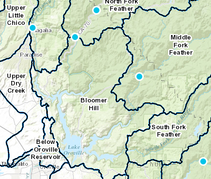
Based on my experience doing these sort of calcs, I expect the inflows are calculated by summing the closest upstream gages with some adjustment to account for intermediate ungaged areas. The gages will be upstream of the lake itself so that the flow area is clearly defined. Almost certainly the gages shown in the CDEC website (blue dots in the image below, taken from http://cdec.water.ca.gov/cdecstation2/): e.g. West Branch Feather at Magalia, North Fork at Pulga, Feather at Merrimac.


The outflow should be a simple hydraulic calculation. The input data will be the reservoir water level, and the dimensions and gate openings for the main spillway control structure. The flow is calculated based on the Bernoulli equation.
 

Attachments

  • gages.PNG
    gages.PNG
    292.5 KB · Views: 401
Status
Not open for further replies.
Back
Top