Oroville Dam Spillway Failure

Status
Not open for further replies.
On the spillway above they are doing a variety of repairs, including filling the gaps between slabs with what looks like epoxy crack weld.

Probably something like this:


Obviously there's a very good chance the main spillway will be used again at some point.

Agreed - and it makes you wonder whether a borescope could be put down those seams to see if there is a void underneath of sufficient scale that the concrete surface could be undermined.

I'm only anticipating the inevitable recriminations about what is no doubt going to be a very expensive recovery exercise.

It's unlikely. More usefully, they should be looking for places where the gaps are wide, and/or the downhill block is raised above the uphill, to avoid (further) hydraulic lift.

From earlier years, we saw pictures of drainpipes produces a dribble. Then the break occurred just downhill from those drainpipes. Then we see a close-up shot that shows the drainpipe completely broken by corrosion--it's clearly not ripped out by force. It's damaged, but it's in a slope that has not been scoured under the force of the flume. It's not hard to connect the dots. We also saw that other drains were operating well. They wouldn't be, if there were a void where the drain pipes were.

It's looking like a kingdom--or at least a hillside--lost "for want of a horse." And indeed, there have been several official announcements that suggest rain damage as the cause of the initial failure.

The image also shows (a) the concrete is plenty tough. The edge is suspended over a voids of up to ten feet wide. But it is sitting on rock. While the rock may not be strong enough to withstand the force of the waterfall, it is demonstrably strong enough--i.e. it hasn't collapsed--to support the hillside behind, and the spillway above.

And (b) while earlier pictures showed brown erosion on the left when there was a dribble of water going over the edge, the latest close-ups show that dribble was going through loose scree, and was presumably little to worry about.
 
it makes you wonder whether a borescope could be put down those seams to see if there is a void underneath of sufficient scale that the concrete surface could be undermined.
From this image DWR posted:

https://pixel-ca-dwr.photoshelter.c...mDTx48Y/I00001wLCUC5cs08/FL-Oroville-7628-jpg

It appears they are using ground penetrating radar to inspect under the spillway. Maybe someone with access to the full res images could get a closeup and confirm. The wheeled device looks very similar to this:


You may well be right; here is a close-up from the DWR image gallery:
SpillwayInspection.jpg
The device is made by a company called "Sensors and Software". I can't find the exact configuration used but from the size the sensor it looks like a "pulseEKKO PRO 500" which uses a 500MHz transmit frequency. Their site says "the 500 MHz is used for granular base and sub-base imaging." This fits with what they would be interested in.
https://www.sensoft.ca/products/spidar/configurations/

Higher frequencies provide higher resolution at the expense of penetration depth. If they were more interested in the concrete itself or searching for rebar/internal conduits etc they could use a 1000MHz sensor which is smaller than the one they are pictured using. They could also combine multiple sensors on a single cart and build a composite picture but again they are not doing that.

Note: this is based on the information available on their website not firsthand experience.
 
About 1 min 24 secs. into the latest DWR video posted today there is footage of the workmen drilling into the base of the area under the spillway that has had shotcrete applied. This is also shown in one of today's new still photos. No explanation of why they were doing so although it looks like it might be in preparation for putting in some reinforcing bars or supports for another layer of concrete:

Source: https://www.youtube.com/watch?v=7LQng6jFJw4


DK_oro_spillway_damage-5650_03_06_2017.jpg

Information is not exactly gushing out about the remedial measures being undertaken in this area but as another press briefing is due soon more may be disclosed then.
 
They are prepping that area to take the water when they divert it, so they can work on the area that currently has water flowing. The holes are to anchor the mesh the shotcrete is going over. IMNSHO as always.
 
workmen drilling into the base of the area under the spillway that has had shotcrete applied. This is also shown in one of today's new still photos. No explanation of why they were doing so although it looks like it might be in preparation for putting in some reinforcing bars or supports for another layer of concrete

or to secure additional scaffolding, or other process infrastructure.
 
Further photos today (Wednesday 8th March) from the DWR gallery:

https://pixel-ca-dwr.photoshelter.c...g/G00003YCcmDTx48Y/Oroville-Spillway-Incident

First one shows the state of clearance below the main spillway, which by this time has probably reached 600K cubic yards of debris or about 1/3 of the total quantity. My question is whether as they clear back toward the foot of the main spillway they are going to cut a channel into the 'canyon' that was formed on the right in case the spillway has to be used again - because frankly I can't see any way they could force the flow down over what remains of its lower structure without more permanent remedial measures:

FL_Oroville-8866.jpg

Second photo, which by now is at least a day old, is of shotcrete at the point of the "waterfall." They don't appear to have started armoring the area further down where the flow of water would actually hit the rock - or not to any great extent as what's on that area (left and center below) appears to be just surplus from what they have done further up:

FL_Oroville-8728.jpg

There are a number of other photos of the area below the emergency spillway that I don't reproduce here but can be found in the gallery linked to above. Of course they have been working on that for weeks and it is armored to a much greater extent than they've been able to do in other areas. Obviously they have to be prepared to use it if the main spillway really can't handle the necessary flow to keep the reservoir level down. Whether it could seems to me to be a big question now.

Thanks for the images, Boilermaker. Seems to me that if they intend to use the main spillway while maintaining the use of the generating plant (which would be quite useful given that the melt will be coming downstream soon), they'd have to harden the area below the end of the intact spillway. What I'd call the "splash zone". I think that if they can prevent most erosion in that area, they will be able to flow water through the main spillway without risking a significant buildup of new debris in the diversion pool. Most of the eroded route is already scrubbed down to bedrock, but that area just under the spillway is not.

My opinion - partly speculation, partly observation - is that they intend to ramp the generation up to cover the inflows over the next few days while they work at hardening/contouring the base of the remaining spillway as well as continuing to clear out the retention pond. That way, when it is again needed, the main spillway can serve to assist the generation through the Hyatt plant to flow sufficient water through the spring melt.

This morning, the generation has been bumped up to flow over 7000 cfs.

source:
http://cdec.water.ca.gov/cgi-progs/queryF?ORO
 
Seems to me that if they intend to use the main spillway while maintaining the use of the generating plant (which would be quite useful given that the melt will be coming downstream soon), they'd have to harden the area below the end of the intact spillway. What I'd call the "splash zone". I think that if they can prevent most erosion in that area, they will be able to flow water through the main spillway without risking a significant buildup of new debris in the diversion pool. Most of the eroded route is already scrubbed down to bedrock, but that area just under the spillway is not.

Beyond the hollows immediately under the spillway, what part of this looks to need immediate shoring up? It looks pretty solid. I agree that the apron of rock extending below the spillway should be protected against weathering, but I see little sign of significant splash damage. The splash damage instead extends all the way to the broken spillway in the foreground.

I'd much prefer to see them delay important work where possible until they can do it right--i.e. after wet season---not just slap shotcrete on everything.

https://pixel-ca-dwr.photoshelter.c...mDTx48Y/I0000g.iUffPMUFg/FL-Oroville-7800-jpg
oroville_plunge_pool.png

it was evident when they had reduced the flow down to about 30,000-35000 cfs - there was fresh mud/brown water coming down that hadn't been visible when they were still flowing near 50,000. To me, it would be a disadvantage to have to use the spillway at 50,000 or 0, and not much in between. I would think that they'd want to minimize erosion if only to prevent rebuilding the amount of debris in the river below.

The area you're speaking of - the apron is the only area where I see an issue, and only up close to the end of the spillway. That appears to be what they're doing, based on more recent images that Boilermaker posted. Once they get down to the blue rock, I think they're OK.


Let me add that I think this is a temporary solution to get through the wet season, because the plant likely won't be able to meet the flow requirements when the snow melt flow starts coming downstream. I don't see how they can get around running the main spillway for that amount of water, and I think it should be done in a way that minimizes adding to the debris buildup below. I wouldn't want them to have to shut down the plant again to dredge the river.
 
Looks like they have four or maybe even five turbines online now:

Flows.png
Source: http://cdec.water.ca.gov/cgi-progs/queryF?s=ORO&d=08-Mar-2017+23:23&span=12hours

Although the outflow now exceeds inflow, reservoir level is rising slightly edging close to what I think is the arbitrary maximum of 860'. Most likely they will have to use the main spillway again at some point but how soon is the question.

In addition, here is an image from the DWR gallery the caption of which refers to completion of the shotcrete under the main spillway edge (which perhaps suggests that they are not intending to armor the splash zone below although that is not what I understood Mr Croyle to say at the last news briefing):

FL_Oroville-8941.jpg

Source: https://pixel-ca-dwr.photoshelter.c...mDTx48Y/I0000riNMwNydK70/FL-Oroville-8941-jpg
 
Last edited:
http://www.sacbee.com/news/state/california/water-and-drought/article137330683.html

Oroville Dam’s heavily damaged main spillway is expected to resume releasing water a little more than a week from now as levels continue to rise in the reservoir.

The state Department of Water Resources announced Wednesday that the battered concrete spillway is likely to begin water releases around March 17. At that point, the level in Lake Oroville is expected to have risen to 865 feet. That’s well below the point at which water would go over the adjacent emergency spillway, but several feet above the comfort level established by DWR acting director Bill Croyle.

The lake was at just below 860 feet Wednesday evening.
Content from External Source
They obviously have to use it at some point. It will be interesting to see how the reinforcements hold up. I suspect it will be fine, based on how it stabilized for several days of 100K cfs.
 
Wednesday's report has apparently been overtaken by events. It was predicated on a necessarily conservative estimate of around 9"/day increases--a rate achieved yesterday evening. As of 11:00, the water outflow is 10,300 cfs, or enough to keep daily increase at around 5", or .02'/hour).* Any further increase should be enough to stabilize the water level. Unfortunately, the inflow measure has gone wrong, and is reporting drastically reduced (and incorrect) numbers.

http://cdec.water.ca.gov/cgi-progs/queryF?s=ORO&d=09-Mar-2017+13:23&span=25hours

03/08/2017 18:00 859.23 2934084 8815 7055(?) 4951 39.48 13.4
03/09/2017 10:00 859.77 2941560 8716 6283(?) 5637 39.48 13.4
03/09/2017 11:00 859.80 2941976 10314 4309(?) 5646 39.48 13.4
03/09/2017 12:00 859.83 2942392 10260 5247(?) 5638 39.48 13.4
03/09/2017 13:00 859.85 2942669 10260 3490(?) 5623 39.48 13.4

Note that during the 16 hours the flow was running at ~8800cfs, the mean hourly increase was .033' per hour, with a measurement error of +/-.02'

That said, there is a 50% chance of light rain in a week, which would change things somewhat.


* estimated by calculating the average rate of increase over several of the different flow rates, as the hourly reports fluctuate significantly.
 
It does appear that something has gone wrong with the inflow reports as (a) they are very erratic and (b) despite inflow regularly being reported as reduced and well below outflow, the reservoir level keeps creeping up, which can't be accounted for by surface water runoff. Anyway it's still just below the 860' mark but only just. At this rate it will take few days for it to get up to 865:
Inflow2.png
Inflow3.png
Source:http://cdec.water.ca.gov/jspplot/js...17+15:51&geom=small&interval=2&cookies=cdec01
 
River release is (mostly) the outflow from Thermalito dam, not Oroville dam. They've been ramping it up steadily, while Oroville has gone up stepwise. This is reported on the ORO dam live data page:
River Release (RIV REL) pertains to the Oroville Complex as a whole which includes any releases from the Diversion Dam gates and Thermalito Afterbay River Outlet.

I don't think the inflow is changing nearly as much as the data shows, even after smoothing hourly data. The water level plot is an extremely steady curve, agreeing very well with the outflow data. (Accuracy is roughly +/-.02')
http://cdec.water.ca.gov/jspplot/jspPlotServlet.jsp?sensor_no=1148&end=03/09/2017+16:22&geom=huge&interval=12&cookies=cdec01
orolevel.png

EDIT:
To get a more reasonable estimate of the actual inflow, I put the last 12 days' data into excel, and plotted changes in hourly (VOL+OUTFLOW), where OUTFLOW is the listed outflow*3600/43560, that is, rescaled from cfs to acre feet per hour. From this, a quick check shows the actual inflow has been stable with a computed average of 14,500cfs for the last 24 hours. (This ignores any volume lost to evaporation or seepage, which is likely below the margin of error in any case.) In comparison, the current outflow is 13,000 cfs, or roughly 1500 cfs less than the adjusted inflow.

Thus the recent inflow data is reasonably accurate, at 13000-16000 cfs.

Where is the inflow increasing from? How is the River Release being increased?
http://cdec.water.ca.gov/cgi-progs/queryF?s=ORO&d=09-Mar-2017+16:22&span=6hours

Sorry, I can't add the page.
 
Last edited:
The photos posted by Boilermaker show work being done to reinforce and protect the repairable portion of the spillway. There are two tasks shown. They are preventing any inflow of water through the spillway into the underlying rock strata by sealing cracks in the spillway surface. Also the exposed rock below the remaining concrete is being sealed with shotcrete. The shotcrete will keep spill water from loosening the foundation rock if the spillway must be used prior to complete repair. The type of "matting" shown in the photo is not installed as a reinforcing material, rather it is used as a barrier to prevent the shotcrete from forming a bond with the rock surface resulting in a gap. This gap will allow water in the rock fissures to migrate down, between the rock and the shotcrete and drain through the pipes shown. The drains will prevent buildup of hydrostatic pressure from groundwater. In the future these drains can be used as pump points for low pressure backfill grouting should that be engineered into the final design.

Thank you,
Mr.Smith
 
DWR noticed for bids for repairs to the Oroville main spillway on July 3, 2009.
http://www.water.ca.gov/engineering/Contracts/index.cfm?Action=3

Spec #09-14 , Contract No. C51399
Spillway Repairs, Oroville Dam, Antelope Dam, Frenchman Dam and Grizzly Valley Dam Notice to Contractors, Advertise 7/3/09

· Notice to Contractors

· Bid Opening Report

· Summary of Bids

The bid notice stated the following needed to be done:

1. Repair spalled concrete on surface of dam spillways, including: a. Sawcutting concrete, b. Removing damaged existing concrete, c. Waterblasting, d. Air/sandblasting, e. Concrete and steel reinforcing work. 2. Repair voids under concrete surface of dam spillways, including: a. Sawcutting concrete, b. Removing concrete, c. Repairing subdrain, d. Concrete and steel reinforcing work. 3. Repair cracks on surface of dam spillways, including: a. Sawcutting or routing of concrete, b. Removing damaged existing concrete edges, c. Placing nonshrink grout, d. Placing epoxy adhesive. 4. Repair expansion and contraction joints, including: a. Removing existing joint seal, backer rod and/or portion of joint filler, and b. Placing joint seal and backer rod.

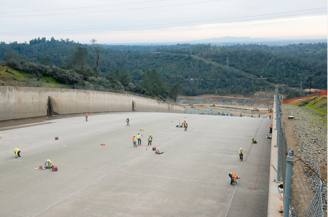
The bid summary shows 10,000 linear feet of sawcutting 1 inch deep, 83 cubic yards of void repair, 3,900 linear feet of major crack repair, 23,700 linear feet of contraction joint repair. I think all contraction joints must have been repaired.

upload_2017-3-10_21-52-8.png

Repairs were also done on Antelope, Frenchman and Grizzly Valley spillways. Antelope Dam required 47 cubic yards of void repair.
 

Attachments

  • 09-14_Summary.pdf
    87.9 KB · Views: 714
Last edited by a moderator:
83 cubic yards of void repair, 3,900 linear feet of major crack repair, 23,700 linear feet of contraction joint repair.

It's not hard to imagine someone making an issue about this, as in why only 83 cubic yards of void repair, where was it to be done and how did they identify the need for it. Of course all manner of second guessing of the maintenance program if not also the original engineering is very likely to happen in the wake of the scale of the damage and the repair effort/cost.

There must have been other maintenance done other than the 2009 effort noted above but the website linked above does not contain any reference to it under "past projects":

http://www.water.ca.gov/engineering/projects_past.cfm

P.S. For more of what I am sure we can expect as regards the condition and maintenance of the spillway there's this piece that appeared today - although in reality it contains nothing new:

http://www.mercurynews.com/2017/03/...s-before-spillway-broke-show-something-wrong/
 
Last edited:
upload_2017-3-11_20-31-21.png
pixel-ca-dwr.photoshelter.com/galleries/C0000OxvlgXg3yfg/G00003YCcmDTx48Y/I0000Ug.1nsIk42E/KG-oroville-repair-16624-jpg

Looks to me as a drilling or coring operation.
 
Looks to me as a drilling or coring operation.

At 30 secs. into the latest DWR video there's footage of this work. Although it's not clear exactly what's being done it does look like drilling into the base below the spillway paving:


Source: https://www.youtube.com/watch?v=iXahsiBzo-A&feature=youtu.be&list=PLeod6x87Tu6eVFnSyEtQeOVbxvSWywPlx


On the subject of spillway inspections and maintenance, there's this useful resource from "HydroWorld.com" excerpted below (it was written in 2008):

http://www.hydroworld.com/articles/...dam-safety-evaluating-spillway-condition.html

Conditions that can lead to failure modes
There are five notable hydrologic conditions that can lead to a spillway failure mode during a spill event. These are:

– Existing structural damage that compromises the spillway;
– Flows that exceed spillway capacity;
– Cavitation damage;
– Significant stagnation pressures that can lead to hydraulic jacking or structural collapse; and
– Foundation erosion related to seepage or groundwater.

Improper gate operation and mechanical gate failures also are possible but are a separate issue and are not covered in this article.

Government organizations, such as the U.S. Department of the Interior’s Bureau of Reclamation, have a comprehensive facility review program for their dams. These reviews are performed on each dam every six years, on a rotating basis. The reviews include evaluation of hydrologic failure modes. Recent findings from the comprehensive facility review program show that past spillway evaluations were not always thorough. As a result, there currently is an increased focus on spillway failure modes during the facility reviews. Potential failure modes related to normal and seismic loading conditions also are evaluated by Reclamation but are not discussed here.
 
It looks like they are rock anchor drilling. As seen in the video, they marked several spots to secure each concrete slab to the rock beneath.
 
https://pixel-ca-dwr.photoshelter.c...I0000CutBRiefa_U/KG-oroville-repair-16961-jpg
20170312-114909-48cew.jpg
A sky crane flies over the Lake Oroville Dam flood control spillway while delivering a power pole that will be used to construct a temporary utility circuit called a shoo-fly. Photo taken on March 11, 2017.
Content from External Source
(The term "shoo-fly" comes from early 1900s usage for a temporary railroad track, probably indirectly from a popular 1870 blackface minstrel song about shooing away flies. See: http://www.word-detective.com/2010/03/shoo-fly/ )
 
Last edited:
https://pixel-ca-dwr.photoshelter.c...I0000CutBRiefa_U/KG-oroville-repair-16961-jpg
20170312-114909-48cew.jpg
A sky crane flies over the Lake Oroville Dam flood control spillway while delivering a power pole that will be used to construct a temporary utility circuit called a shoo-fly. Photo taken on March 11, 2017.
Content from External Source
(The term "shoo-fly" comes from early 1900s usage for a temporary railroad track, probably indirectly from a popular 1870 blackface minstrel song about shooing away flies. See: http://www.word-detective.com/2010/03/shoo-fly/ )
It just seem to me that everything that there doing is temporary!
 
My opinion is the drilling is for a grouting operation. They will want any voids under the slabs filled to equalize bearing pressure and to prevent ground water migrating where it doesn't belong. Subsurface water buildup can create in situ pressure that the original design did not account for. The original drains were installed to prevent this buildup. They may be damaged.

Thank you,
Mr.Smith
 
In the following video, narrator Juan Browne describes the River Valve Outlet System and the reason that they are not using it. He also describes the conditions at the Oroville Dam at the time of his video. The river valve discussion begins around time 4:10 - 4:15...


Source: https://www.youtube.com/watch?v=_q0g43iI9kA


He goes over their history, including the damage incurred in 2009, and the subsequent replacement in 2014. They river valves were operational until recently when they were, according to the video, removed from service to upgrade the fire protection system. That is unverified, but this individual's videos have been fairly well researched, not meant to induce panic, and easy to follow.

He also states that they are capable of flowing 4-5000 cfs.
 
Interesting info...

In 1997 the main spillway was operated ABOVE its rated capacity of 150,000 cfs
They ran it at 160,000 cfs and most of Orville was evacuated.

http://www.chicoer.com/article/NA/20170218/LOCAL1/170219704

The Main Spillway (a.k.a the Flood Control Outlet) is rated up to 250K before the emergency spillway kicks in.


The evacuation in 1997 was because of possible levee failure, and they only evacuated low lying areas.
 
Status
Not open for further replies.
Back
Top