Anna Reynolds
Member
From an update by County Supervisor William Connelly:
https://m.facebook.com/story.php?story_fbid=1683579861668957&id=100000508772678
Relevant excerpt:
"
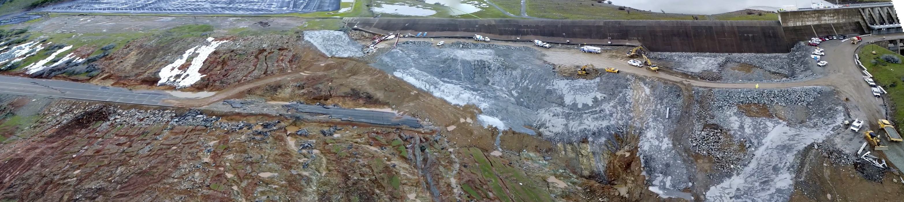
Looks like the heavy equiptment work we were seeing on the banks of the pool in earlier photos may have been in preparation for this new "low flow channel"
Also looks like they are ramping up outflow to 60,000cfs, per the Butte County Sheriff's office:
https://m.facebook.com/story.php?story_fbid=785455638271383&substory_index=0&id=119221578228129
https://m.facebook.com/story.php?story_fbid=1683579861668957&id=100000508772678
Relevant excerpt:
"
"External Quote:o removal taking place in multiple locations from land to build what DWR is
referring to as the "low flow channel" to get water around the large debris piles at the
bottom of the primary spillway.
o Elevation of water at the Hyatt power plant has been lowering so that water is not going
into the plant – once the "low flow channel" is in, that level will continue to decrease.
Construction and repairs continue on the emergency/auxiliary spillway. The weather is not
stopping the progress, though it may be slowed down periodically.
No further erosion has been seen on or near the primary spillway. It is being monitored and
evaluated 24/7.
PG&E continues to relocate lines below the spillway. Anticipate being completed by Tuesday.
Lake elevation at 9 AM was 852.30 feet. Only two feet from the 850 goal.
Current inflow approximately 45,000 cfs. DWR anticipates it will peak on Tuesday morning at flows
that could exceed over 100,000 cfs. The average inflow over the next several days could be around
68,000 on Monday and Tuesday. Outflows are expected to stay at 55,000, but could be adjusted
upwards as necessary. DWR is extremely confident that the lake can easily hold the expected
precipitation through the Tuesday storms. The lake may get above the 850 level, but they expect
nothing even resembling a problem...
Looks like the heavy equiptment work we were seeing on the banks of the pool in earlier photos may have been in preparation for this new "low flow channel"
Also looks like they are ramping up outflow to 60,000cfs, per the Butte County Sheriff's office:
https://m.facebook.com/story.php?story_fbid=785455638271383&substory_index=0&id=119221578228129
Last edited:
")