Which Gimbal scenario is more likely — 30 NM or 10 NM?

Entropy is very interesting, but how it is relevant to the case here, I'm not sure.

I'll note two things :

- the close trajectory was seen on SA, to go with your analogy it's like if you have an employee from the card factory telling you he's seen somebody shuffling the cards out of the machine. You can of course not trust him.

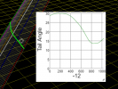
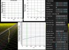
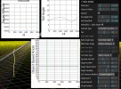
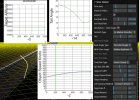
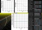
- the incredibly coincidental straight line is not incredibly straight/levelled/steady. Here it is with constant altitude in Sitrec on the left. And my reconstruction on the right, I find the same need for acceleration (from 250 to 380 Knots, average 320), to catch up with the lines of sight.
1660982163642.png
1660982194232.png

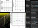
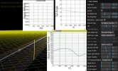
And if you want to have some sort of linear decrease in tail angle to explain the linear change in glare shape/size, it's even more difficult to find a straight line. You can of course make all kind of speculations on how a glare would or would not change linearly with tail angle.
 

Attachments

  • 1660982382397.png
    1660982382397.png
    50.4 KB · Views: 108
Entropy is very interesting, but how it is relevant to the case here, I'm not sure.
I just explained how it's relevant. The last sentence introduced no new information, it summarized the rest of the post.
- the close trajectory was seen on SA, to go with your analogy it's like if you have an employee from the card factory telling you he's seen somebody shuffling the cards out of the machine. You can of course not trust him.
In this analogy, an employee of the card factory would be the pilot or someone otherwise involved with the piloting of the object. We obviously don't have access to that. You're also missing the point of the analogy: if someone shuffled the cards out of the machine, you agree with me the cards have been shuffled. Any of the 52! possible orderings is (roughly) equally likely after a good shuffle, so the probability it will come out in the proper order is 1/52!. So seeing the deck is in order is pretty good evidence it was intentionally placed that way. On the other hand, seeing a deck placed in some random arbitrary order like the one in my last post is not good evidence it was intentionally placed that way, because just about any of those "out of order" orderings would look equally "out of order", just like any random curved trajectory would look curved. Saying "but this is what the SA showed" is begging the question.
- the incredibly coincidental straight line is not incredibly straight/levelled/steady. Here it is with constant altitude in Sitrec on the left. And my reconstruction on the right, I find the same need for acceleration (from 250 to 380 Knots, average 320), to catch up with the lines of sight.
"I couldn't find a trajectory with these properties" != "a trajectory with these properties doesn't exist". Sitrec for example finds exact solutions for one out of constant speed, constant altitude, or straight line. This is a realistic problem with realistic uncertainties, however, and the real solution would not be an exact match for either, but would be a close match for all.
1661026954558.png
1661026962526.png
1661026975608.png

As you can see, there's some wiggle room here. What's wrong with Edward Current's original reconstruction?
And if you want to have some sort of linear decrease in tail angle to explain the linear change in glare shape/size
That's not a requirement. The change in glare size isn't even that linear to begin with.
size.png

As discussed in the other thread, this is a more complicated problem with more moving parts.
 
Entropy can be a confusing concept sometimes (in particular when it was a new concept - it was roundly rejected), but the closely related concept of (Kolmogorov) complexity applies equally well.
External Quote:
Consider the following two strings of 32 lowercase letters and digits:

abababababababababababababababab , and
4c1j5b2p0cv4w1x8rx2y39umgw5q85s7

The first string has a short English-language description, namely "write ab 16 times", which consists of 17 characters. The second one has no obvious simple description (using the same character set) other than writing down the string itself, i.e., "write 4c1j5b2p0cv4w1x8rx2y39umgw5q85s7" which has 38 characters. Hence the operation of writing the first string can be said to have "less complexity" than writing the second.
-- https://en.wikipedia.org/wiki/Kolmogorov_complexity
Indeed, both concepts apply in this particular case. There is one important difference however, that entropy has a contextual character whereas Kolmogorov complexity doesn't. In the cards example, the Kolmogorov complexity of "spades diamonds clubs hearts, all A to K" is likely smaller than "A through K of Spades, A through K of Diamonds, K through A of Clubs, and K through A of Hearts", but the latter is "lower entropy" because it's the one configuration that's considered special (because it's the order manufacturers often use). By the same token, while the Kolmogorov complexity of a pure straight line is smaller than that of a curved constant altitude trajectory, in the present context the latter has smaller entropy because the statistical distribution we would define entropy with respect to, for this problem, is that of plausible aircraft trajectories.
 
Indeed, both concepts apply in this particular case. There is one important difference however, that entropy has a contextual character whereas Kolmogorov complexity doesn't. In the cards example, the Kolmogorov complexity of "spades diamonds clubs hearts, all A to K" is likely smaller than "A through K of Spades, A through K of Diamonds, K through A of Clubs, and K through A of Hearts", but the latter is "lower entropy" because it's the one configuration that's considered special (because it's the order manufacturers often use). By the same token, while the Kolmogorov complexity of a pure straight line is smaller than that of a curved constant altitude trajectory, in the present context the latter has smaller entropy because the statistical distribution we would define entropy with respect to, for this problem, is that of plausible aircraft trajectories.

The latter is "new deck order" - so lower kolmogorov complexity too. Of course, everything's only defined relative to the language of known terms that is shared between the participants in the information exchange.
 
"I couldn't find a trajectory with these properties" != "a trajectory with these properties doesn't exist". Sitrec for example finds exact solutions for one out of constant speed, constant altitude, or straight line. This is a realistic problem with realistic uncertainties, however, and the real solution would not be an exact match for either, but would be a close match for all.

We don't really see what's going on in your screenshots.

A straight trajectory of a distant plane should not be that hard to find, with all the refinements that have been made. Yet, straight-line trajectories, at 31Nm and 38Nm, look like this:

31NM 38Nm
31Nm Straight.JPG
38Nm Straight.JPG


Changes in tail angle are close to what Edward had found, but speed is all over the place. I'll repeat myself but I found the same in my reconstruction, speed is not steady for a distant straight path. No idea why Sitrec is different from Edward's model.

With constant speed :
31NM 38Nm
31Nm Constant Speed.JPG
38Nm Constant Speed.JPG


You can unzoom and from the top these will look more or less straight, but it looks like there are signifiant changes in heading (see video below to illutrate).


How large are these changes in heading ? I wish I could do it myself rather than suggesting Mick to do it, but I think it would be useful to have speed/altitude/heading indicated real-time along flight path. Then one should be able to share a video like mine above, showing the most plausible trajectory for the distant plane scenario, with numbers that make sense for a straight-leveled-steady trajectory. To me at this point in Sitrec, there is no incredibly coincidental straight-leveled-steady trajectory anywhere.

Next step would be to show the reconstruction to Ryan Graves, and he could pass it to the WSO who could tell us if another of their F-18 (what else?) could have been flying at 30-40Nm from them, at ~19000ft, in this direction, given the fighters from their squadron were all going back to the carrier.
 

Attachments

  • 31Nm Constant Altitude.JPG
    31Nm Constant Altitude.JPG
    187.1 KB · Views: 127
  • 31Nm Constant Speed.JPG
    31Nm Constant Speed.JPG
    187.2 KB · Views: 123
  • 31Nm Straight.JPG
    31Nm Straight.JPG
    182.5 KB · Views: 133
  • 38Nm Constant Altitude.JPG
    38Nm Constant Altitude.JPG
    192.7 KB · Views: 130
  • 38Nm Constant Speed.JPG
    38Nm Constant Speed.JPG
    186.7 KB · Views: 116
  • 38Nm Straight.JPG
    38Nm Straight.JPG
    232.9 KB · Views: 125
Last edited:
I copy what I posted in another thread, the clouds are also to slow compared to the real vid. This is the problem with basing everything on how the clouds look, it's hard to see how exactly angular motion matches. But it has to be done, here looking at how many frames it takes to span one FOV, at different points of the video.

Frames per FOV crossed (left:vid ; right:sim)
from frame #0: 70 vs 85 (sim 20% slower)
from #301 : 81 vs 108 (25% slower)
from #601 : 136 vs 180 (25% slower)
from #801 (1/2FOV) : 85 vs 140 (65% slower)

This is not meant to criticize Sitrec, but hopefully help to get it more accurate. Maybe refining the angular motion will reveal a straighter line, maybe not, I don't know.
 
You can unzoom and from the top these will look more or less straight, but it looks like there are signifiant changes in heading (see video below to illutrate).
Something that we've observed with contrails (and some Flat Earth observation) is that it does not take much to make a path look bent when viewed from the end. I think that showing such a perspective-compressed image is rather misleading.
 
It seems these wiggles in heading are about 4° for the 31Nm path, ~10° for the 38Nm path. A plane going straight doesn't do that.

What do you think of the cloud motion speed and do you agree with my measurements above?
 
It seems these wiggles in heading are about 4° for the 31Nm path, ~10° for the 38Nm path. A plane going straight doesn't do that.

What do you think of the cloud motion speed and do you agree with my measurements above?
@Mick West , no comment?

A closer look at what's going on at the key moment between 26 and 30s
Jump at 26s.png


A small jump in the FOV, that can also be seen in this stitched panoramic view.
Cloud Stitching Video 1 Edited.png

Cloud Stitching Video 2 realigned Edited.png


This would be quite a turbulence for a leveled distant plane at 30-40Nm.
 
I don't think you can really stitch the clouds together very well. Why is it curved? Cloud tops are flat.
 
That's why I made the 1st image with perfecty flat clouds, to check if we see the jump there too.
But the "flatness" of the clouds isn't the crenulated top profile, it's their direction of motion (because the camera never changes in altitude.)
 
Just want to share here that close paths for Gimbal do not have to involve freaky or spooky physics. With wind included (roughly facing the object's direction) we can find solutions that exhibit a stop on the SA display, with no sharp vertical U-turn and moderate Gs (0.7G max).

The object needs to turn to the left at relatively low speed, decelerating under wind speed (120 Knts) as it does, making it look like a straight path that reverses direction on the SA, due to the effect of wind on the ground track. See an illustration below with the velocity vectors to visualize it (blue vector is air track, green vector is ground track).

What's unusual about that path is the climb in altitude, low speed, and of course the IR signature with no apparent means of propulsion, for an object at that distance (9Nm at the start).

Not saying it is the path, but I want to point out that a close path matching Graves' recollection does not need to involve insane physics. Which is relevant to this topic about likelihood of close versus distant paths.


Last edited:
a close path matching Graves' recollection does not need to involve insane physics.
It's still highly unusual. You've got an object that is:
  1. Traveling in a straight line viewed from above
  2. Slowing down with a deceleration that varies fairly linearly from 0.1 to 0.7g
  3. Slowly gaining altitude at rate that's very gradually increasing
  4. Coming to a dead stop along that line, while still rising vertically.
If the frame of reference of the air mass, it has to perform a weird artificial curve to maintain all these things (or just totally be ignoring wind)

To illustrate this, I've add an "air track" thin blue line that shows up when you toggle the wind display.

2022-10-06_10-36-36.jpg


This shows the path the object takes in the frame of reference of the air. Since the air is all moving in the direction of the cyan arrow, then the end result its the yellow line, the ground track (which I guess I should make green).

So it has to do this weird mathematical decelerating turn to the left in order to do the weird mathematical "stop and go back" ground track.

Compare to the Gimbal (Far) scenario (with target wind at 270, so you can see it)
2022-10-06_10-43-04.jpg


Since it's a straight line at a constant speed, the "air track" is just another straight line.

And, again, this all is what @Edward Current said some time ago.
The reason why the 10 NM trajectory is smooth and mathy is that it's a projection of a straight line up the sightline, not a real trajectory in space. I've used this analogy before, but long ago, it was assumed that when a planet in the sky appears to turn around and go retrograde, that's the object's actual path. In reality the object is moving along an ellipse, and the U-ey path is what happens when you view that ellipse from Earth. A random U-ey in the sky does not project to an ellipse in space, unless by sheer coincidence. But the planetary U-eys do. (I'm pretty sure that's why Kepler's ellipse model was so compelling.)

In summary: Realistic, physical trajectories don't work out to straight lines elsewhere on a sightline. Straight lines however do work out to unrealistic, un-physical trajectories elsewhere on the sightline, which is what we have at 10 NM. Or: It's not just that the 30 NM trajectory is minimal. It's that the 10 NM trajectory is a geometrical projection of a minimal trajectory — and, a rather extreme, un-physical one at that.
 
Last edited:
This shows the path the object takes in the frame of reference of the air. Since the air is all moving in the direction of the cyan arrow, then the end result its the yellow line, the ground track (which I guess I should make green).

I've now made it green.

Also, the "air track" moves with the air. You can think of it as being the contrail left by the craft. Contrails are almost always at an angle to the actual ground track of the plane, as they get carried along by the air moving (i.e., the wind). (This can be a little confusing)
 
Nice to see the air track along with the ground track.

I recall Edward also proposed radar glitch at some point, to explain how the close path could have been seen by the aviators on radar. I find it difficult to defend a distant plane scenario that is completely unrelated to what's going on within 10Nm, given the coincidences it involves. With spoofing involved, I'm listening. My scenarios are for those who are unsatisfied (like me) about a scenario that leaves everything about the fleet and SA up in the air.
 
Even in the case of a randomly generated, smoothly accelerating/jerking trajectory along some camera sightline derived from an arbitrary cloud motion, the corresponding straight and level solution (if any) might be hundreds of miles away. It might be behind the observer. It might require extraordinary speed. But 30 NM is only 3x the distance of 10 NM, and the required speed for a plane at that location (380 knots) happens to be the speed of a plane.

Howdy, I really appreciate all of the work put into this by everyone. I've looked at numerous threads on the gimbal video on here as well as Mick West's YT video on the glare/rotation which I found thoroughly and unequivocally compelling.

I have some nagging questions related in part to the quoted text above.

Let's take the speeds/ trajectories implied by the 10nm assumption as the parameters of this hypothetical object, "10nm gimbal's" capacity for movement.

We know "10nm gimbal" can move at x max speed with y acceleration and turn at z degree angles etc.

"30nm gimbal" moves like a plane.

How likely is it that — were "10nm gimbal" to take a slightly different flightpath — this could also be resolved into a corresponding and reasonable straight and level solution?

That is, within "normal" ranges (in front of and not extraordinarily distant from the observer) and traveling at a reasonable speed?

What happens if we only make minor (hypothetical) modifications which still resemble "10nm gimbal's" speed/ trajectory?

Can we still arrive at "plane zone" solutions manipulating distance only, as is the case with the existing 10nm model and 30nm?

How much do we have to deviate from "10nm gimbal's" speed and trajectory before we don't have a "plane zone" solution?

My other questions are:

How does the size of the object, zoom etc in the visualizer factor into the current 10nm vs 30nm scenarios? (Apologies if this has been addressed).

Is elevation a constant here in the 10nm and 30nm models? (Again, apologies if addressed)

Is 30nm the only distance at which the object's current "10nm" flight path can be resolved into a reasonable straight and level? Or would say, 25nm or 35nm produce similar results?

Thanks, apologies for any lack of clarity.
 
How likely is it that — were "10nm gimbal" to take a slightly different flightpath — this could also be resolved into a corresponding and reasonable straight and level solution?

That is, within "normal" ranges (in front of and not extraordinarily distant from the observer) and traveling at a reasonable speed?

What happens if we only make minor (hypothetical) modifications which still resemble "10nm gimbal's" speed/ trajectory?

Can we still arrive at "plane zone" solutions manipulating distance only, as is the case with the existing 10nm model and 30nm?

How much do we have to deviate from "10nm gimbal's" speed and trajectory before we don't have a "plane zone" solution?
That's a great question, and something I probably should have checked at the time. I suppose the best way to do that would be set up straight-and-level scenarios at the fringes of the "plane zone," e.g., too fast and too slow (for a conventional plane, anyway). Regarding distance, naïvely one might expect that moving the 10 NM solution to 5 NM would move the straight-and-level solution to 15 NM, but that may not be true.

The reason I focused on an alternate scenario of 10 NM / moving along a straight line as seen from overhead is to approximate the witness accounts of the object on radar at about that distance coming to a stop and then going in the opposite direction. There are plenty of other alternate solutions that one might consider, but only the one straight-and-level one.
How does the size of the object, zoom etc in the visualizer factor into the current 10nm vs 30nm scenarios? (Apologies if this has been addressed).
That's tricky because it depends on whether you're operating on the assumption that (a) the image is of the object, or (b) the image is a glare. If (a), we expect the onscreen diameter to be inversely proportional to distance. If (b), we don't; it might be more like the square of the difference.

The diameter of the image projected out into space, i.e. the diameter of the object under condition (a) above, is something like 15 feet at 10 NM and 45 feet at 30 NM. (Based on the image having an angular size of about 50 arc-seconds)
Is elevation a constant here in the 10nm and 30nm models? (Again, apologies if addressed)
Not sure what you mean. The elevation of the surface, being the Atlantic Ocean, is constant. Earth's curvature is accounted for. The elevation angle of the camera is –2° and the F-18's altitude is 25,000 feet, as shown on the display.
Is 30nm the only distance at which the object's current "10nm" flight path can be resolved into a reasonable straight and level?
Yes, given the cloud motion and other known parameters, 30 NM is the only possible straight/level solution. This is confirmed in Sitrec.
 
Yes, given the cloud motion and other known parameters, 30 NM is the only possible straight/level solution. This is confirmed in Sitrec.

Not only at EXACTLY 30 NM though, with wind there's a variety of situations that look like plausible aircraft trajectories around 30 NM, from around 27 to around 35.

And the solutions are a bit forced, sticking to exact airspeed or exact altitude, a better approach (as @Edward Current suggested a long time ago) is to use some kind of AI search to find a path that best thread through all the parameters, within the error bars. A genetic algorithm perhaps - something I've been meaning to do for a while.
 
The diameter of the image projected out into space, i.e. the diameter of the object under condition (a) above, is something like 15 feet at 10 NM and 45 feet at 30 NM. (Based on the image having an angular size of about 50 arc-seconds)
Is that a new calculation? I don't recall it, but then there are a lot of things I don't recall.

If the calculation is correct, it is a stumbling block for those who think that the image is a good representation of the object at 10NM. Even viewed tail-on, 15 feet would be narrow for the width of a conventional jet plane, including wings. E.g. the wing span of an F-18 is about 40 feet. At the longer distance 45 feet would be OK for a fighter jet but not for an airliner, which would normally have a wingspan of over 100 feet and sometimes over 200 (e.g. 260 feet for an Airbus).

This suggests that either (a) the image is not a good representation of the object, (b) it is a smallish plane, like a jet fighter, but at a long distance, or (c) it is not a conventional jet plane. It might be something more like a cruise missile - or of course an alien spaceship!
Pretty sure the small size of the object in the 'saucer shaped, actual object at 10nm' theory was discussed in the original thread.
 
Is that a new calculation? I don't recall it, but then there are a lot of things I don't recall.
Yes and no. A couple of years ago I estimated the angular size to be ~50 arc-seconds (in order to compare it to Venus). 0.35° (NAR zoom level 2) is 21 arc-minutes = 1,260 arc-seconds, so, 1/25th of the width of the FOV. The tangent of 50 arc-seconds is .00024.

If the actual object is close to the same temperature as the background, which seems reasonable, then the object itself might be invisible, even if it's larger than the IR signature.
 
Just a thought, but can we use parallax plus the fact that the 'UFO' is visibly just above the horizon to establish the distance ? It would appear that the horizon is actually visible in the latter part of the Gimbal video. I presume that is the sea horizon. We know the fighter jet is at 25000 feet, and we know the angle at which the UFO is being observed. Relative to the horizon, that surely has to give us a distance if we are arguing that the bulk of apparent motion is parallax......though my brain hurts when I do trigonometry relative to a curved surface.
 
Just a thought, but can we use parallax plus the fact that the 'UFO' is visibly just above the horizon to establish the distance ?
That's basically what @Edward Current has been doing. The problem is that the object is likely moving (few objects with a heat signature like that above the open sea are wind-blown), and that unknown motion overlays the parallax effect.

If you assume a constant speed of the target, then you end up at ~30 nm (via @Mick West ).
If you assume ~10 nm and a straight ground track, you end up with the vertical J-hook maneouver.
Both solutions satisfy the parallax constraints.

(I just think the J-hook makes no sense. @TheCholla thinks it fits the witness recollections.)
 
Just a thought, but can we use parallax plus the fact that the 'UFO' is visibly just above the horizon to establish the distance ? It would appear that the horizon is actually visible in the latter part of the Gimbal video. I presume that is the sea horizon. We know the fighter jet is at 25000 feet, and we know the angle at which the UFO is being observed. Relative to the horizon, that surely has to give us a distance if we are arguing that the bulk of apparent motion is parallax......though my brain hurts when I do trigonometry relative to a curved surface.
I don't think the horizon/sea is visible in the image. Here's what we have about halfway through the sequence, with and without clouds. The orange square is the field of view. From 25,000 feet, the Earth curves away "faster" than the –2° angle of the sightline.

Screen Shot 2023-07-10 at 9.31.05 AM.png
Screen Shot 2023-07-10 at 9.31.39 AM.png


If I lower the camera elevation to the minimum, –2.5° (and assume very low-altitude clouds), then the horizon is in the FOV, but it's obscured by clouds; here again with the clouds removed:
Screen Shot 2023-07-10 at 9.46.12 AM.png
 
Last edited:
I don't think the horizon/sea is visible in the image.

It seems to me to be quite clearly visible.....its not all lumpy like the clouds but is a straight line between dark and lighter area for almost 20 seconds of the video, and quite distinct at times....

gimbal.jpg
 
Last edited:
It seems to me to be quite clearly visible.....its not all lumpy like the clouds but is a straight line between dark and lighter area for almost 20 seconds of the video, and quite distinct at times....
Barring mistakes on my part, I think that could only be the horizon if the camera angle is lower than –2.5°, and the clouds end along a line that's roughly parallel with the sweep of the picture.

Perhaps the position of the horizon can be checked on Sitrec.

This line could be a boundary between thermal layers of the atmosphere, in black-hot mode, darker being warmer...which might also explain why it changes visibility and sharpness over the course of the 34 seconds. I would expect a sharper, more consistent line throughout if it's demarcating surface water vs. air, but I don't know.
 
It seems to me to be quite clearly visible.....its not all lumpy like the clouds but is a straight line between dark and lighter area for almost 20 seconds of the video, and quite distinct at times....

View attachment 60337
So what data do you think is false, then? The 25,010 ft. of altitude? The -2⁰ camera angle? Or is the Earth flat?

Article:
Distance = 200 miles (1056000 feet), View Height = 4.73 miles (25000 feet)
Actual Radius = 3959 miles (20903520 feet)

With the refraction approximation* giving an effective radius of 4618.83 miles
Refracted Horizon = 209.19 miles (1104534.74 feet)
Refracted Drop= 4.33 miles (22873.64 feet)
Refracted Hidden= None, refracted horizon is beyond the target distance
Refracted Horizon Dip = 2.593 Degrees, (0.0453 Radians)

Remember the field of view (FOV) of the ATFLIR is only 0.35⁰ in that mode.
 
So what data do you think is false, then? The 25,010 ft. of altitude? The -2⁰ camera angle? Or is the Earth flat?

But surely as you get higher the actual horizon will be lower down than an artificial 'horizon' that is simply 90 degrees all round from the zenith. I mean, travel all the way to the Moon and the horizon of the Earth will be at -179.75 degrees relative to a plane parallel with the Earth's surface. So it would not surprise me that at 25000 feet the true horizon is 2 degrees below the artificial one....and that -2 is surely a -2 relative to the artificial horizon.

So if I'm right then that 'UFO' is quite literally a fraction of a degree above the true horizon.

I am assuming that the artificial 'horizon' on a plane is essentially an arc perpendicular to a line intersecting the plane from the center of the Earth. To point a plane at the true horizon would not give level flight, as the true horizon will always be below the artificial one that keeps a plane at the same altitude.
 
Last edited:
But surely as you get higher the actual horizon will be lower down than an artificial 'horizon' that is simply 90 degrees all round from the zenith. I mean, travel all the way to the Moon and the horizon of the Earth will be at -179.75 degrees relative to a plane parallel with the Earth's surface. So it would not surprise me that at 25000 feet the true horizon is 2 degrees below the artificial one....and that -2 is surely a -2 relative to the artificial horizon.
–2° is definitely relative to the artificial horizon, i.e., what is level locally.

The beauty of 3D modeling is you don't have to rely on intuition, which apparently in this case is wrong. You put in the data and see what happens; no intuition or thought experiments required. Nobody expected a straight-and-level trajectory to emerge, either.

It sounds like you are just underestimating the effect of the curvature of the Earth. Check it out on Sitrec and see what you find.
 
But surely as you get higher the actual horizon will be lower down than an artificial 'horizon' that is simply 90 degrees all round from the zenith. I mean, travel all the way to the Moon and the horizon of the Earth will be at -179.75 degrees relative to a plane parallel with the Earth's surface. So it would not surprise me that at 25000 feet the true horizon is 2 degrees below the artificial one....and that -2 is surely a -2 relative to the artificial horizon.

So if I'm right then that 'UFO' is quite literally a fraction of a degree above the true horizon.
I have quoted the curve calculator result for you, above. It states that the "true" or "actual" horizon is at -2.593⁰ when the observer is at 25,000 ft, e.g. attached to an F-18.

My point is that a camera with a 0.35⁰ FOV cannot point at -2⁰ and see the horizon at -2.593⁰; the horizon is necessarily out of shot below.

The UAP/heat signature at -2⁰ is ~0.6⁰ above the "true horizon".

But it would appear the horizon indicator does not even show the decimal part....so all we can say is the horizon displayed in the cockpit is somewhere between -2 and -3.....which your -2.593 indicates it is. In which case what I am pointing out as the sea horizon is the sea horizon. It is quite clear and distinct for a long part of the video.
 
But it would appear the horizon indicator does not even show the decimal part....so all we can say is the horizon displayed in the cockpit is somewhere between -2 and -3.....which your -2.593 indicates it is. In which case what I am pointing out as the sea horizon is the sea horizon. It is quite clear and distinct for a long part of the video.
The assumption is that –2.6°, on the display, is rounded to –3°, and that –2° on the display reflects anything from –1.5° to –2.5°. We have no reason to believe that –2.6° or –2.9° would be rounded down to –2° onscreen, except perhaps motivated reasoning.

Of course, since we're dealing with fractions of degrees in a moving aircraft, we could be outside the margin of accuracy error, which is unknown. But there's a 50% chance the accuracy is off in the other direction.

The following remains true:
Barring mistakes on my part, I think that could only be the horizon if the camera angle is lower than –2.5°, and the clouds end along a line that's roughly parallel with the sweep of the picture.

There's also no explanation for why the horizon disappears completely at times. That's easily explained by the line not being the horizon, but instead, a thermal layer above the clouds. (Stratocumulous clouds tend to form under inversion layers, i.e., the air above them is unusually warm, or darker in black-hot mode. The resulting atmospheric stability is why their tops stop at a very particular altitude, as seen here.)

But even if you were right, there's nothing we can do with the horizon. It's completely featureless, so it can't be used to determine distance by parallax. So what's the point?
 
But it would appear the horizon indicator does not even show the decimal part....so all we can say is the horizon displayed in the cockpit is somewhere between -2 and -3.....which your -2.593 indicates it is. In which case what I am pointing out as the sea horizon is the sea horizon. It is quite clear and distinct for a long part of the video.
Why would the indication of -2 not mean -1.5 to -2.5?

Edward Current puts the angle at -2.22⁰ to make the clouds look right, see https://www.metabunk.org/threads/gimbal-blender-simulation-with-clouds.12209/post-263807 . I'm not convinced there's a way to position the clouds as in the video with a down-tilt strong enough to make the horizon visible.
 
Why would the indication of -2 not mean -1.5 to -2.5?

In which case why the quibbling over .093 of a degree ? If -2 can mean -2.5, then Edwards -2.593 is barely 1/10 of a degree off the -2.5 to -3.5 limit. And I somehow doubt a plane banking 60 degrees in 34 seconds maintains a 1/10 of a degree accuracy.

What's more, if the -2 is actually -2.5, given that we know the width of the field is 0.35 degrees.....the UFO is about 1/15th of that width above what I am suggesting is the actual horizon then we have another 0.023 degrees to play with anyway. So one can argue that the diving line between light and dark that one sees is just 0.070 degrees off the true horizon. Which to all extents and purposes would mean it is the true horizon.

The relevance ? Well, if that is the true horizon then it is a fixed point relative to which we can judge the angular distance relative to that horizon...and that will tell us if the UFO is at 10nm or 30nm, as the jet fighter maintains a constant 25000 feet. The UFO does appear to get a little closer to that horizon during the course of the video...as one would actually expect. But clearly the amount closer it would get would be less at 30nm than at 10nm.
 
Last edited:
The relevance ? Well, if that is the true horizon then it is a fixed point relative to which we can judge the angular distance relative to that horizon...and that will tell us if the UFO is at 10nm or 30nm, as the jet fighter maintains a constant 25000 feet. The UFO does appear to get a little closer to that horizon during the course of the video...as one would actually expect. But clearly the amount closer it would get would be less at 30nm than at 10nm.
I'm not sure what can be done with this, since the 3D modeling shows that the sometimes-visible line is not the horizon; the horizon is lower and hidden by the clouds. Maybe you can work something up and present your findings here? Have you tried doing it on Sitrec?
 
In which case why the quibbling over .093 of a degree ?
Because it's 1/4 of the FOV.

just 0.070 degrees off the true horizon. Which to all extents and purposes would mean it is the true horizon.
No, because it's 1/5 FOV off the true horizon.

This would be absolutely obvious in the picture.

Just because the number looks small doesn't mean it means little.
 
Just because the number looks small doesn't mean it means little.

True, why I think a readjustement on target of 2-3° at each step rotation (Sitrec Gimbal sim) would cause more than a little bump in the image.
This implies 6-8 FOV are crossed one way by the pod roll to catch up, the other way by an internal mirror to recenter, at each step rotation, in a handful of frames, with almost no disruption in the image.

I don't see evidence for the camera readjusting by 6-8 FOV, when looking at the bumps frame by frame. It looks like a minor readjustment. I know of a quote from Lacy Cook (patent holder for the ATFLIR gimbal system) saying that the range of the internal pointing/tracking/stabilization mirror is "something like XXX micro-radians". 999 micro-radians=0.05°.

FYI we also have another Raytheon engineer on record saying that the "pitch/roll/yaw motors are constantly working" (Twitter).
 
Because it's 1/4 of the FOV.

But if we consider that -2 means -1.5 to -2.5...then -2.593 is a trifling 0.93 degrees off that upper range and is well within that .35 degrees FOV. If the -2 is actually -2.5, then the true horizon at -2.593 is 1/3 of the field of view below the cross hairs in the video. So the true horizon would be within the video frame range. I have only to wonder just how accurate this display is, banking 60 degrees at x hundred mph at 25000 feet to wonder if the apparent horizon just fractionally away from that is actually the true horizon.
 
Back
Top