U-Turn contrail near San Francisco [NASA502 GLF3 Survey Plane]

SR1419

Senior Member.
I felt like a true contard today as I was snapping photos of contrails from a moving car....and I am ashamed/proud to say it was my wife who pointed it out :D

photo 1(3).JPG

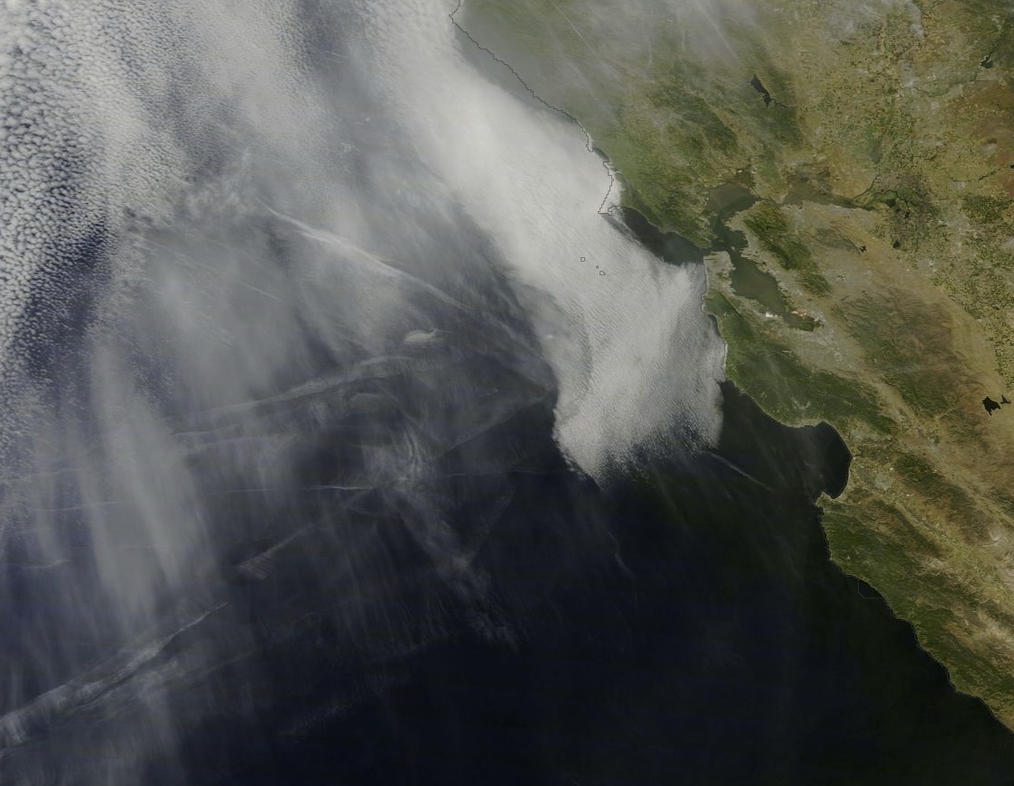
Not really a "race track" contrail as it just made one pass but a big loop of a contrail. My guess is that it was climbing after taking off from SFO or San Jose? The older portion of the trail was heading east to west and then west to east after the u-turn. The older portion seems much lower than the newer portion but we know how that goes. In the second photo the trail(s) are the same just the "U" portion was out of frame.

A very contrail-ly sky today despite a record setting heat wave...but there is a front moving pushing down from the PNW and pushing some upper level moisture with it...and hopefully a sea breeze will follow this afternoon.

Can anyone with more flight search skills help track down the flight....these pics were taken at approximately 11:20am PST over southern Marin county, CA.

photo 2(4).JPG
 
Last edited by a moderator:
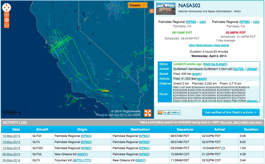
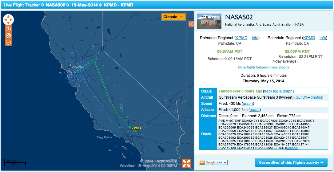
Can anyone with more flight search skills help track down the flight....these pics were taken at approximately 11:20am PST over southern Marin county, CA.

My guess is that it was climbing after taking off from SFO or San Jose?

Er, I'd suggest that any local departures won't have made the contrails. The upper photo seems to show an approximately 90° turn and seems to be at a fairly constant altitude.

Any number of reasons for this....one that I can think of, given your location, is an inbound flight from the Pacific that wasn't allowed a more direct route to its West Coast destination, and was made by ATC to fly in, then turn using the domestic routing Airways. This would be unusual, but possible heavy traffic conflicts might have made it necessary. I cannot tell (in photo #1) what direction your camera was pointing. (NW or SE, etc?)

One possible scenario, using this SkyVector link (purely speculative):
http://skyvector.com/?ll=37.02828472727246,-122.91394042898222&chart=304&zoom=3

Say a flight using R465 and then Control 1173H was made to come all the way to the WOODSIDE (OSI) VorTac, then turn northwards towards its destination...maybe Seattle, perhaps elsewhere.

Normally one would not find it efficient to "Coast In" in that manner, but sometimes the selection of over-water routes can be limited, and thus allowances made, when flight planning.

Again, only one possible speculation....until we discern the actual flight, then we will better be able to determine its actual flight plan.
 
Last edited:
When I see similar contrails in the UK, they are usually left by one of Raytheon Sentinels.
In your place they are probably produced by a Gulfstream III flying at a similarly high altitude:

Screen shot 2014-05-15 at 23.46.42.png
http://www.flightradar24.com/2014-05-15/18:20/12x/GLF3/356ca6a

You beat me to it this time :) I saw that GLF3, but the track seemed rather jacked, and I was unsure if it was a glitch or not.

This is where it starts and ends, so it was certainly flying around for a while, just not quite as jaggedly as the track suggests.
 
Last edited:
When I see similar contrails in the UK, they are usually left by one of Raytheon Sentinels.
In your place they are probably produced by a Gulfstream III flying at a similarly high altitude:

Screen shot 2014-05-15 at 23.46.42.png
http://www.flightradar24.com/2014-05-15/18:20/12x/GLF3/356ca6a

So are you saying that G-3 was orbiting over the area? That would certainly explain a lot.

Of course, conspiracies will infer some ulterior motive to this, but as usual, such activity always has a very benign explanation.

I should add that there are MANY reasons for such a pattern of flight, by an airplane such as a G-3. Usually related to avionics testing of some sort, and after knowing the ownership of the airplane, then things will become more clear.
 
It's a NASA flight NASA502, mapping earthquake faults.
http://www.nasa.gov/centers/armstrong/news/FactSheets/FS-089-DFRC.html#.U3WC_JQv-I4

NASA's Armstrong Flight Research Center operates a C-20A, a military version of the Gulfstream III business jet, as an environmental science research aircraft for a variety of geophysical research missions. The aircraft has been extensively modified and instrumented for the role, including installation of a sophisticated synthetic aperture radar in an underbelly pod, a self-contained on-board Data Collection and Processing System (DCAPS) and a precision autopilot that enables the aircraft to fly repeat passes over a target within 15 feet of the original flight path.

The twin-turbofan aircraft provides long-term capability for efficiently conducting airborne environmental science missions for NASA, other government agencies, academia, and private industry.

UAVSAR

The Unmanned Air Vehicle Synthetic Aperture Radar (UAVSAR) is sophisticated synthetic aperture radar system developed by NASA's Jet Propulsion Laboratory in Pasadena, CA. Developed initially for carriage by remotely operated unmanned aircraft, the UAVSAR is mounted on the C-20A in a specially designed pod that will be interoperable with unmanned aircraft in the future.

The UAVSAR uses a technique called interferometry to detect and measure very subtle deformations in Earth's surface. The sensor is designed to gather data for geological studies on earthquakes and volcanoes, ice and glacier movement supporting climate change studies, biological studies supporting ecology and carbon cycle science, and oceanography research.

Since the UAVSAR was installed in 2007, the aircraft has flown more than 2,000 data-collection flight lines, most from an altitude of 41,000 feet.
Content from External Source
This is from a different day, but has the full radar track (attached)


https://flightaware.com/live/flight/NASA502/history/20140515/1615Z/KPMD/KPMD
This is from today, and actually has the same complex route filed as a flight plan:


(Methodology: Noticed it was a Gulfstream 3, and started and ended the flight in Palmdale. So googled for "Gulfstream 3" + Palmdale. Flightaware link for NASA502 was the first result)
 

Attachments

  • FlightAware_NASA502_KPMD_KPMD_20140402.kml
    36.1 KB · Views: 997
Last edited:
Back
Top