Fin
Senior Member.
Skywatcher (or someone) "leaked" some ufo videos a few days ago. A friend who saw them before the links were deactivated roughly described to me what he saw. My first guess was more Tetra Class UAP (more accurately known as "birds"), because Skywatcher seem like they couldn't identify a coke can on a picnic table from 100 yards.
These types of UFO misidentifications have been discussed here before. They're classic LIZ (low information zone) examples, where when we do get better footage of the same thing and manage to zoom in, we can see its obviously birds, primarily from the flapping of wings. Although the flapping is not immeditately apparent in these new Skywatcher vids (hence LIZ) literally everything else about them is entirely consistent with known videos of birds, from the slightly altering formations, to the speed & trajectory. There is actually flapping & wings, but its distorted, much like the stars, meaning that to the untrained eye it looks like it might be "anomalous". Its not.
There's so much wrong with Billy's analysis (I call it BroPixel analysis) its not even funny. Well, it kind of is.
Source: https://x.com/BillyKryzak/status/1949193914583527533
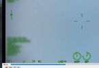
As we can see here below: More "Tetra Class" UAP. Until, that is, we zoom in, overcoming the LIZ, enabling us to see the wings flapping. Nothing about the new skywatcher vids suggests anything different is happening.
"Visual references_ Flock of Birds, night time"
Source: https://www.youtube.com/watch?v=23lk-GzwwhQ
These types of UFO misidentifications have been discussed here before. They're classic LIZ (low information zone) examples, where when we do get better footage of the same thing and manage to zoom in, we can see its obviously birds, primarily from the flapping of wings. Although the flapping is not immeditately apparent in these new Skywatcher vids (hence LIZ) literally everything else about them is entirely consistent with known videos of birds, from the slightly altering formations, to the speed & trajectory. There is actually flapping & wings, but its distorted, much like the stars, meaning that to the untrained eye it looks like it might be "anomalous". Its not.
There's so much wrong with Billy's analysis (I call it BroPixel analysis) its not even funny. Well, it kind of is.
Source: https://x.com/BillyKryzak/status/1949193914583527533
As we can see here below: More "Tetra Class" UAP. Until, that is, we zoom in, overcoming the LIZ, enabling us to see the wings flapping. Nothing about the new skywatcher vids suggests anything different is happening.
"Visual references_ Flock of Birds, night time"
Source: https://www.youtube.com/watch?v=23lk-GzwwhQ
Attachments
Last edited: