Red Winged UFO, Mufon case 91964 - Plane Lights

Mick West

Administrator
Staff member
MUFON 91964 Metabunk Compare.jpg

This case of a "UFO" submitted to Mufon, is described as:
https://mufoncms.com/cgi-bin/report...=f1_submitted_datetime+DESC&case_number=91964
2018-05-08
8:59PM
Amber colored light pattern observed thru a telescope. Aztec, NM, US
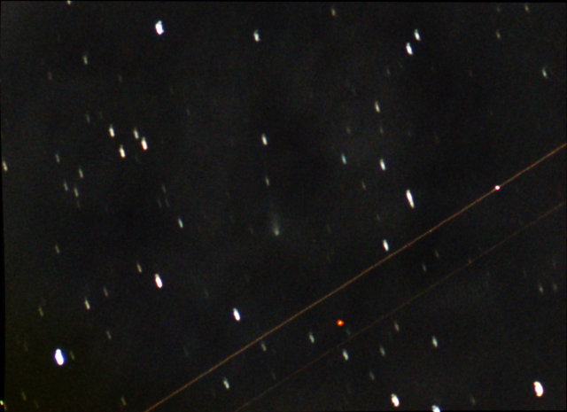
I was in my backyard doing astrophotography. My subjects that night were a pair of galaxies in the spring sky, NGC4631 and NGC4656 in the constellation Canes Venatici. My equipment was a 103mm apochromatic refractor and a Canon EOS 6d DSLR. I was shooting 3 minute sub frames at the time. The object appeared on one of my subframes as it crossed thru the field of view. My first impression was that it was some satellite or high flying aircraft. One of my submitted photos shows how far the object moved across the frame during this particular 3 minute exposure. I just continued shooting more 3 minute frames of the galaxy field with the intention of deleting this frame from my total set of 15 frames to be stacked later for the final picture. The object never appeared in any of my other frames and I did not see anything like it again that night. NOTE: The dimensions of the galaxy the object flew by ( NGC4631 ) is approx. 10' x 1.5' of arc. so the object would have been quite small. Its astronomical magnitude was estimated at 8.0
Content from External Source
The first impression was correct. However, the resultant photo seems a little confusing.
Metabunk 2018-05-14 10-05-08.jpg

The problem is that you naturally interpret this as a set of three lights. But what it actually is is a single light, the red collision avoidance strobe. This is a very bright flashing light, that illuminates other parts of the plane, even in the daytime.
767-beacon-animated.gif

In this case, it's illuminating the engines.
Metabunk 2018-05-14 10-08-40.jpg

Another clue are the two faint bright red spots under the main light
Metabunk 2018-05-14 10-12-03.jpg
This matches quite well with the wheel wells of a 737
Metabunk 2018-05-14 10-14-02.jpg

The time given is 2018-05-08 8:59PM, that's 2018-05-09 (next day) 2:59AM in UTC. The camera EXIF time gives the same UTC time - maybe that's common for astrophotography? Looking at that location, a likely candidate is SWA1988 from Phoenix to Omaha, which was passing just to the South at 39,000 feet.
Metabunk 2018-05-14 10-21-17.jpg

Another thing that throws people off here is the thin lines. These are the long exposure traces of navigation lights, but they seem odd as you can only see two of them, and they don't seem to line up with the other lights. However, if you look carefully, or just boost the levels, then you can see there actually are three lines.
Metabunk 2018-05-14 10-29-45.jpg
What's more, the one on the left is green, and the one on the right is red, which matches standard wingtip lights.

They don't line up for a somewhat unintuitive reason - planes do not fly in the direction they are facing. They fly in the direction they are facing at their airspeed PLUS the velocity of the wind relative to the ground. So if there's a crosswind, the motion of the plane can be 5° or more off from the direction it is facing.
 

Attachments

  • FlightAware_SWA1988_KPHX_KOMA_20180509.kml
    14.7 KB · Views: 823
Last edited:
For a minute I wondered why the plane didn't block the stars behind it in the picture (or does it?), but that is of course because it's a long exposure photograph.
 
It would be nice to get some video of a 737 doing the same thing. Unfortunately most available video seems to have landing lights on as well, which somewhat obscures the effect. But here's a demonstration of the light illuminating the engines:
Metabunk-2018-05-14-10-49-49.gif
 
For a minute I wondered why the plane didn't block the stars behind it in the picture (or does it?), but that is of course because it's a long exposure photograph.
That's another thing that throws people off, even if they don't really think about it their brains assume it's a small craft because they can see all those stars.
 
We can tell the direction of the camera because:
2018-05-08
8:59PM Amber colored light pattern observed thru a telescope. Aztec, NM, US
... My subjects that night were a pair of galaxies in the spring sky, NGC4631 and NGC4656 in the constellation Canes Venatici.
Content from External Source
Setting the location, date and time, and searching for NGC4631 gives us:
Metabunk 2018-05-14 21-12-35.jpg

Zooming in
Metabunk 2018-05-14 21-13-39.jpg

So that's that heading (Az) of 92.5 degrees, and looking up (Alt) at 67°. The plane was at 39,000 feet, so that puts the camera 39000/tan(67 degrees) =16,500 feet to the West of the plane's track
 
But if the camera is looking East, the if we align the photo with the night sky at that time, then it seems to suggests the plane was flying roughly to the West, not the same as the plane I'd identified earlier.
Metabunk 2018-05-14 22-21-24.jpg
 
The reflections off the engines are interesting and not something I've captured before, but I do occasionally capture a jet passing through the field of view. Here's a shot from 2013 while I was tracking comet ISON:
 
Assuming the galaxy is 10' long as he says, the distance (in arcmin) between the engines is about 3' or 0.04-0.06 deg.
Az/Alt = 93/67 deg
Aztec elevation: 5646 ft
Airplane altitude: 38000 - 39000 ft

Using the following formula we can get an estimate of what the distance in feet between engines should be:
v = 2 arctan(x / (2 h))
where v is the width in angles (degree)
h distance to airplane in ft
x distance between engines in ft

Taking the altitude of 67 deg into account:
h = (38500-5650) / sin 67
Assuming no roll or pitch (and a flat earth :)) the apparent distance between the engines is
x = X sin 67
where X is the real distance between engines

this gives us:
X = [ 2 (39000-5650) tan(0.06/2) ] / [ (sin 67)^2 ] ~= 41 ft
X = [ 2 (38000-5650) tan(0.04/2) ] / [ (sin 67)^2 ] ~= 26 ft
best est:
X = [ 2 (39000-5650) tan(0.049/2) ] / [ (sin 67)^2 ] ~= 34 ft

I.e. the engines are about 26-40 ft apart.

From what i can tell the engines on a Boeing 777-200 is about 72 ft apart, but on a Boeing 737 they are 32 ft apart. (I couldn't find particularly reliable data on distance between engines on a boeing 777 though.)

So the Boeing 737 and flight SWA1988 seems like the best candidate.
 
Last edited:
Assuming the galaxy is 10' long as he says, the distance (in arcmin) between the engines is about 3' or 0.04-0.06 deg.
Az/Alt = 93/67 deg
Aztec elevation: 5646 ft
Airplane altitude: 38000 - 39000 ft

Using the following formula we can get an estimate of what the distance in feet between engines should be:
v = 2 arctan(x / (2 h))
where v is the width in angles (degree)
h distance to airplane in ft
x distance between engines in ft

Taking the altitude of 67 deg into account:
h = (38500-5650) / sin 67
Assuming no roll or pitch (and a flat earth :)) the apparent distance between the engines is
x = X sin 67
where X is the real distance between engines

this gives us:
X = [ 2 (39000-5650) tan(0.06/2) ] / [ (sin 67)^2 ] ~= 41 ft
X = [ 2 (38000-5650) tan(0.04/2) ] / [ (sin 67)^2 ] ~= 26 ft
best est:
X = [ 2 (39000-5650) tan(0.049/2) ] / [ (sin 67)^2 ] ~= 34 ft

I.e. the engines are about 26-40 ft apart.

From what i can tell the engines on a Boeing 777-200 is about 72 ft apart, but on a Boeing 737 they are 32 ft apart. (I couldn't find particularly reliable data on distance between engines on a boeing 777 though.)

So the Boeing 737 and flight SWA1988 seems like the best candidate.

Brilliant, wish I had thought of that. Here's the astrometry of his image:
http://nova.astrometry.net/user_images/2160988#annotated
Indeed this does confirm the galaxy ID and the coordinates at the center of the strobe light (12hr 42m 29.4s, 32d 36' 25") correspond to an alt of 67.3 degrees and an azimuth of 92.9 degrees at 2:59 UTC from Aztec, NM.
sin(altitude) = sin(declination)*sin(latitude)+cos(declination)*cos(latitude)*cos(hour angle)
cos(azimuth) = (sin(declination)-sin(latitude)*sin(altitude))/(cos(latitude)*cos(altitude))
We can then use the astrometrically solved image to get a more precise reading of the angular separation of the engine reflections:
http://h.dropcanvas.com/lbgg4/enginesep.jpg
Looks like your best estimate of 0.049 degrees was just about right on the mark according to my measurement, which as you show above corresponds to ~34 feet part give or take. Not bad.
 
Someone did something similar in another thread, I just realised you could do the same here.
In hindsight I think I made a mistake with x = X sin 67. I was thinking the plane was flying from left to right horizontally, but it looks more like it is coming straight at the camera, and in that case x = X. The reflections on the engines are probably a bit off center so 0.049 is a bit smaller than the actual engine separation. But you get about the same range anyway, so the conclusion is the same.

Is there is a website where you can see historical flight data (for free)?
 
I can get track data for a particular flight back to about 6 months, but I can't replay all flights for a particular date and time, as far as I know. Here is UAL275.
UAL275.PNG
 

Attachments

  • FlightAware_UAL275_KEWR_KLAX_20180508.kml
    48.7 KB · Views: 849
Last edited:
I tried looking at planefinder but it looks like planes appear and disappear suddenly. Is it because they get their data from ADS-B and there is not good coverage everywhere?

It looks like it was only a few km from the camera position so the plane must have flown very close to Aztec.
 
It looks like it was only a few km from the camera position so the plane must have flown very close to Aztec.

Isn't the position of the camera a known unknown? The unknown plane, if UAL275, has a known track . This would put him slightly north, and a bit west of the track of UAL27, somewhere in the bush about 20 km. north of Aztec?Capture.PNG
 
True, but it looks like UAL275 was also a boeing 777-200. If I'm right about it having about 70 ft between the engines then the angular separation of the engine reflections should be closer to 0.14 degrees.
2*arctan((70*sin(67)) / (2*(32000-5650))) = 0.14

I couldn't find any exact dimensions but I got about 70 ft from this picture:

777exterior200_300_short_range.png


It's a pretty short flash, so I the image itself shows the relative size and spacing of the engines. If it's just the fairing being lit then it seems to fit the 737 better. But here's the 777 overlaid. Still plausible.
Metabunk 2018-06-23 06-20-59.jpg
 
A 777-200 would have an angular separation of 0.14 degrees at that altitude though, but Astro measured it to be closer to 0.049.
 
I just looked at the original photo, and noticed a second strobe flash, and a passing satellite? They should provide a bit more information to fix the location etc.IMG20032mod.jpg
 
Last edited:
The flash periods are probably quite accurate, although this is not a requirement, as I understand things.
.Capture.PNG
https://aviation.stackexchange.com/questions/24151/airplane-strobe-light-pattern
From the speed of the plane and flash period you can get a distance scale and distinguish Airbus and Boeing by comparing to wing span.
You should be able to get camera Latitude by adjusting the viewer position in Stellarium until the satellite track and stars line up where they are supposed to be. The exposure time span must include the satellite position/time. Because of a long exposure and speed of a satellite the longitude would not be very precise. I am on a backup PC so I don't have it available now.
I wonder if these are wing tip and tail strobes:
Capture.PNG
 
Last edited:
I don't know how to figure out what satellite it could have been. (Could it also have been a meteorite?)

If they are stars they are incredibly uniform; same coloured lines are the same length and parallel:

upload_2018-6-25_3-7-15.png

If that's the strobes, then the yellow lines provides a measure of the wingspan which is much easier to find data on for different aircraft type (than the engine separation).

We can also measure the distance between flashes, but we don't know the frequency. I assumed the red beacon flashes 1 time per second just to see what figures one would get, and they look sensible in that case.

If choosing between a 737 and a 777, the numbers fit a 737 the best (wingspan of about 100 ft). The 777s wingspan of 200 ft would put it at an altitude above 60'000 ft.

Measured from picture
If 56.5 px = 0.0491636 deg (derived from astro's measurment) then:

Red flash
1480,2 px = 1,288 deg
Distance:
813 ft @39'000 ft altitude
788 ft @38'000 ft
642 ft @32'000 ft​
Speed (assuming 1 flash/sec)
892 km/h
865 km/h
705 km/h​

Wing flash
226,0 px = 0,197 deg
124 ft @39'000 ft
120 ft @38'000 ft
98 ft @32'000 ft​
This corresponds to about 0.15 duration relative to the red flash​

Wingspan
212,75 px = 0,185 deg
117 ft @39'000 ft
113 ft @38'000 ft
92 ft @32'000 ft​

Specs from Wikipedia articles
Boeing 737
Cruise speed: 796 km/h
Wingspan:
93 ft [ 737-100/200 ]
95 ft [ 737-300/400/500 ]​
Cruise speed: 838 km/h
Wingspan:
113-117 ft [ 737-600/700/800/900 ]
118 ft [ 737 MAX-7/8/9/10 ]​

Boeing 777
Cruise speed: 892 km/h
Wingspan:
200 ft [ 777-200/200ER/300 ]
213 ft [ 777-F/200LR/300ER ]​
 
Last edited:
Very nice analysis! From the light flash sequence, the Planefinder research, engine placement vs. arc, to my favorite...the crab angle against the wind aloft!

At first it was bugging me that the single white NAV-light wasn't in line with the anti-collision light. Assuming it's not already offset (or parallax, up high on tail?), that's a decent crab angle. This can be calculated too using an E6-B flight computer. Wind aloft history is available at http://aviationwxchartsarchive.com/product/windc however we seem to be past the archive window for May 9th.

The photo is now my desktop background :)
 
Oops, I should have done May 8-9. I added a day to comply with ZULU, but that was already done. They only allow one archive request per email. Unless someone else is interested in submitting a request, I'll wait a few days and try again.
 
Well the wind data never arrived. Still, making some assumptions, an an aircraft doing 400KTS on a 270 track(due westbound) would be heading of 278, and the wind would be out of the north at 56KTS. Just eyeballing it with a paper protractor overlay (limited computers here at work, someone with Photoshop please help) the flight track vs heading in this photo seems about 8 degrees off.
 
The wind data finally arrived. At 0000Z that night at FL300 the (forecast) wind was 330@40KT. The track (in the posts above) appears about 250. So that should be a 5 degree correction angle at 450KTS (increases to 6 degrees at 400KTS).

E6B_Wind.png
 
Back
Top