Problems with Identifying Contrails in FlightRadar24

this article is a joke. I take photos of sky trails every day as I ride my bike 2-4 hours not too far from where this data was taken. Yesterday between 12:30 and 4:45 I saw 42 trails. Today (Oct 6th) I saw 38.
It's NOT the number of trails that is important, though it seems you're trying to debunk chemtrails by talking about how many contrails there are. The difference between yesterday and today is that the TRAILS LASTED LONGER. They persisted longer and thus looked longer. There were even a few that seemed to be chemtrails but they were just real long contrails.
Trails last longer when the air is more moist (as you say). That was real obvious since there cirrus clouds covering the sky. Seeing more persistent contrails does NOT negate that chemtrails exist!!!!!!!!! (and I saw a few between 6:00 pm and 7:00 pm yesterday)
 
Last edited by a moderator:
Seeing more persistent contrails does NOT negate that chemtrails exist!!!!!!!!!

No it does not. However it does explain how these trails are consistent with contrails, given the weather. Hence you can't use trails like these as evidence of "chemtrails".

Yesterday there were trails too, I took several photos of them yesterday. However they were focussed in the afternoon and evening, not in the morning. The point here is comparing the same time yesterday with today. I'm sure you would agree there were dramatically more persistent trails in the morning today. They weather readings explain why.

I'd be interested in your local photos that you think are "chemtrails". Have you tried identifying the planes on FlightRadar24?
 
yes, I have tried to ID them with flightradar24.com. The weird thing is that USUALLY when I see a trail (short one) and I note the time, location, and flight direction, there is NO flight to match. It makes me wonder if they're drone flights from Beale AFB. Last year there were three persistent trails, one after another, over my house, all in the exact spot in the sky and going the same direction and flightradar24.com showed none of them. Some while back, I photo'd a trail that was obvious not a regular trail because it was like Morse Code, with obvious on-off-on-off-on-off-on pieces of trail. (I'm trying to find that one to check with flightradar24.com to see if I can ID that but flightradar24.com only goes back 6 months.
I have thousands of photos for the last few years. I've been keeping better notes on when where and what direction of the flights lately.
 
Upper temps and Rh(i) are always changing depending on altitude and upper atmosphere conditions....and changes are not surprisingly.... variable hour-to-hour. These changes can usually determine the persistence of ice (persistent contrails) left by water vapor producing engines.
It's not a leap of faith, to realize that upper air has variable conditions.
This is why natural clouds are not connected in one large mass.....they are separated and defined by the conditions at their altitude and humidity.


....and the idea of them being "drone flights" (vs. manned flights) has no bearing on the weather at any altitude or conditions....does it ?
It's good that you are looking and checking.
 
Last edited:
The weird thing is that USUALLY when I see a trail (short one) and I note the time, location, and flight direction, there is NO flight to match
this would be easy enough to prove. start taking brief video. you can pick up a cheap enough little digital camera if you dont have one.
show the time on your cellular and GPS (there are apps for that) and then pan up and vid the contrail for a few seconds.

I think everyone here would be interested in just how many of these alleged unidentified flights you can find.
 
Some while back, I photo'd a trail that was obvious not a regular trail because it was like Morse Code, with obvious on-off-on-off-on-off-on pieces of trail.
What makes you say that isn't a regular trail? Such behaviour is quite common with ordinary contrails and easily explained by small variations in humidity.

http://contrailscience.com/broken-contrails/

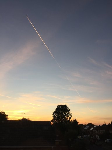
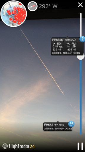
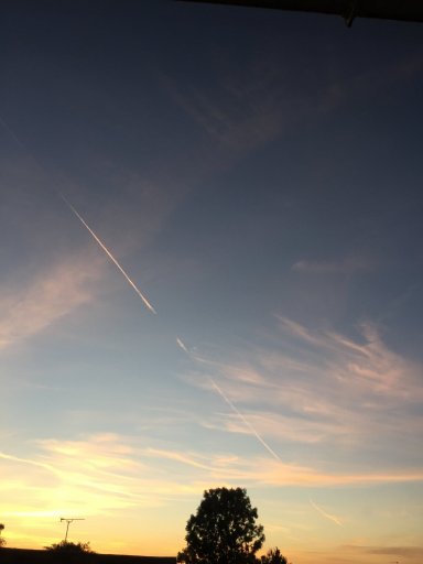
I see such trails fairly regularly, created by perfectly ordinary passenger planes which show up on FR24 (as does virtually all of the air traffic I see here in England).

Recent example (the compass calibration is often slightly out when I take the screenshots, but FR6656 was definitely the flight).

IMG_6537.JPG IMG_6538.PNG IMG_6539.JPG
 
Steve Holmes.... there are many people here that are certain in what they believe.
Don't take that as they ganging-up on you.
One important part is that you have claimed to have already tried to find the flights.

Two notes.....Planes located visually in the sky, and planes found on FlightRadar24 normally have a slight gap in time, 10 minutes lag-time is often.....from where you estimate seeing them from the ground, and when they show-up on the site.
Also, not all flights are required to transmit the ADS-B information as of yet.....that FlightRadar24 uses.
I believe 2020 is the tentative date for ADS-B requirement.

What are the ADS-B rules?
The FAA published Federal Regulation 14 CFR § 91.225 and 14 CFR § 91.227 in May 2010. The final rule dictates that effective January 1, 2020, aircraft operating in airspace defined in 91.225 are required to have an Automatic Dependent Surveillance – Broadcast (ADS-B) system that includes a certified position source capable of meeting requirements defined in 91.227. These regulations set a minimum performance standard for both ADS-B Transmitter and the position sources integrated with the ADS-B equipment your aircraft.
https://www.faa.gov/nextgen/programs/adsb/faq/#g9
Content from External Source
Mick's OP post goes into great detail, explaining the circumstances you may have not really read quite well. Have another look.
 
yes, I have LOTS of pictures of broken contrails, many of them taken today. They are caused by a plane going through spots of lesser and more moisture (near a cloud). What I saw (and I hope to dig out) is tiny repeated breaks and what I have is not the same. All the pieces and breaks were tiny and equal before it totally stopped.

I mentioned drones. Somewhere I also have a set of photos where a trail goes up the valley, turns back down, goes east, goes west, went back north, and then off into the east. That is not a regular flight for an airliner but I learned (by experience of seeing it) not long ago that a high flying Cessna can make contrails and it could have been a Cessna or similar plane flying at 39 or 40,000 feet.

As to the lag time of flightradar24.com that you mention, that's not true. When up in Tahoe, I frequently sit on the porch, watch flightradar24.com to see an approaching flight and then see it go over right on schedule.

I don't care about people "ganging up" on me. There's lots of IGNORANT people (frequently trolls) who do that all the time. I have evidence. They have their opinions made up from listening to propaganda.
 
Elegantly simple solution...totally looking forward to seeing what you see, Steve. :)
Here's an example of how what I see doesn't match what flightradar24.com shows from yesterday. I made a white line segment to show what/where/when I saw a trail. The purple line is of a Cessna, which as it shows, was flying at 29 thousand feet, which is the only aircraft high enough at the time to make a trail.16-10-05 trail-2 1054 no flight heading N, E of downtown.jpg
 
I don't care about people "ganging up" on me. There's lots of IGNORANT people (frequently trolls) who do that all the time. I have evidence. They have their opinions made up from listening to propaganda.

Excellent, examining claims of evidence is what this site is all about. Please review the posting guidelines and start a thread to present your evidence.

Welcome BTW :)
 
I made a white line segment to show what/where/when I saw a trail. The purple line is of a Cessna, which as it shows, was flying at 29 thousand feet, which is the only aircraft high enough at the time to make a trail.

It's worth remembering that contrails don't necessarily follow the path of the plane, as they get deflected by the wind. Clearly that is not the case here, as the front of the trail should still track closely with the path of the plane, but it's worth bearing in mind.

And remember that not all traffic shows up on FR24. Where I live in England, the vast majority of flights do (Flybe is a notable exception), but I gather that the proportion is considerably lower in America.

And if you live in an area with military activity then you'll probably see plenty of trails from untracked planes. The racetrack loop you mention sounds like it could well be one of those.

BTW as regards the lag time, that can indeed be true. Most flights show in real time, but those without that option can be displayed using public FAA radar tracking data, which is subject to a delay.

Edit: I see you are in the Sacramento area. That's not far from @Mick West so he may be more familiar with the traffic in that area. You might even be able to coordinate contrail observations!
 
It's worth remembering that contrails don't necessarily follow the path of the plane, as they get deflected by the wind. Clearly that is not the case here, as the front of the trail should still track closely with the path of the plane, but it's worth bearing in mind.

And remember that not all traffic shows up on FR24. Where I live in England, the vast majority of flights do (Flybe is a notable exception), but I gather that the proportion is considerably lower in America.

And if you live in an area with military activity then you'll probably see plenty of trails from untracked planes. The racetrack loop you mention sounds like it could well be one of those.

BTW as regards the lag time, that can indeed be true. Most flights show in real time, but those without that option can be displayed using public FAA radar tracking data, which is subject to a delay.

Also, if using the playback, ensure that you are converting local time to UTC
 
To avoid latency and to see aircraft that (increasingly) don't want to appear on FlightRadar24 etc. receive the transmissions direct from the aircraft yourself. Capture.PNGA dongle to do the job can be got for about £5, and you only need to receive what you can see visually. In this case SPG236 is not transmitting its position but is located by MLAT, which is possible if you share your data.
 
Last edited by a moderator:
Here's an example of how what I see doesn't match what flightradar24.com shows from yesterday. I made a white line segment to show what/where/when I saw a trail. The purple line is of a Cessna, which as it shows, was flying at 29 thousand feet, which is the only aircraft high enough at the time to make a trail.16-10-05 trail-2 1054 no flight heading N, E of downtown.jpg

There's two possibilities
  1. The aircraft was not on FR24
  2. It was on FR24, but you did not find it
Both of these things happen. The first happens with military planes, and a few others, not a lot you can do about it (although sometimes they show up on other sites). The second can often be rectified by re-examining the data.

Lines draw on maps generally do not match the reality of the track. Photos are very useful. A wider view sometime yields fruit. Just going roughly off your white line, perhaps it was further away and higher, like Alaska 317.
20161007-064801-jns61.jpg


Again though, very hard to tell without a photo.
 
Two notes.....Planes located visually in the sky, and planes found on FlightRadar24 normally have a slight gap in time, 10 minutes lag-time is often.....from where you estimate seeing them from the ground, and when they show-up on the site.

Actually I don't really see that gap any more. FR24 flight display seems generally within a few seconds of where the plane should be for pretty much all the planes I see round here.

I have an ADS-B receiver as well, but just a tiny antenna (so far). It does not pick up many planes. But here's a live view compared with FR24 (this is a single screenshot, so both programs are at the exact same point in time)
20161007-070138-u61tp.jpg

No real difference for practical purposes.

The 10 minutes delay used to be for planes tracked with FAA data. I think now when they use FAA data they extrapolate it to get a very close approximation on the current position. But most traffic has ADS-B
 
And if you live in an area with military activity then you'll probably see plenty of trails from untracked planes. The racetrack loop you mention sounds like it could well be one of those.
There were a couple different instances here on MB that turned out to be those "surveyor" planes over California as well.
 
I don't care about people "ganging up" on me. There's lots of IGNORANT people (frequently trolls) who do that all the time. I have evidence. They have their opinions made up from listening to propaganda.
You obviously arent familiar with Metabunk, there are at this point hundreds of instances that the guys (or an outside reader) posts a picture of a contrail and it is very rare if the plane does not show up on FR24. Every contrail i have ever looked up, I have found the plane as well.

I think if you "usually" cannot find the plane from a fresh contrail (one you SEE being laid) ,then as Mick pointed out above, you are probably just unfamiliar with the angle /distances of contrails.
 
Actually I don't really see that gap any more. FR24 flight display seems generally within a few seconds of where the plane should be for pretty much all the planes I see round here.

I have an ADS-B receiver as well, but just a tiny antenna (so far). It does not pick up many planes. But here's a live view compared with FR24 (this is a single screenshot, so both programs are at the exact same point in time)
20161007-070138-u61tp.jpg

No real difference for practical purposes.

The 10 minutes delay used to be for planes tracked with FAA data. I think now when they use FAA data they extrapolate it to get a very close approximation on the current position. But most traffic has ADS-B

I think FlightAware has a delay of about 3min. but FlightRadar24 does not (usually). The playback of historical data though can be quite in error. I think it is probably planefinder.net that still sees military planes here, but they will probably fall in line before long.
 
Good. I have wanted a participatory ADS-B receiver.....how much does it cost, and is it easy to get ?
EDIT:
https://www.flightradar24.com/apply-for-receiver

Dump 1090 seems best, and can run on Windows and a Raspberry pi. The easiest setup is to use the precompiled versions from FlightAware or FlightRadar24 etc. if you don't mind feeding data to them.

Note that if you leave the HTML display running it crashes the feed after a while.
 
Dump 1090 seems best, and can run on Windows and a Raspberry pi. The easiest setup is to use the precompiled versions from FlightAware or FlightRadar24 etc. if you don't mind feeding data to them.
I feed to FR24. They give you a free business subscription, worth $50/month!
 
I already have a GPS 10mhz disciplined receiver.....so another antenna wouldn't hurt .

Now how do we get real-time weather Sounding data ??.....

(back to topic)

Like this, If you must..
https://www.coaa.co.uk/sondemonitor.htm

edit: Plus a DVBT dongle and something like SDRSharp, and possibly a 'virtual audio cable' to connect the audio output of SDRSharp to the input of Sondemonitor.
I have had Sondemonitor working on XP with audio by cable from SDRSharp on Win8, but problems, so far, with win8/10 for both..

You get a nice sonde track on Google Earth too, if you check the right boxes and download some GPS data files you need from NASA?
 
Last edited:
Got to get a bigger antenna first. I get like 10% of the traffic I can see out my window.
I took me a while to figure out that it was the ethernet over mains thing that killed mine when I moved the antenna upstairs. Getting rid of that made much more difference than the new dongle, filter and antenna, although I think the FlightAware antenna is a great deal.
 
...... (I'm trying to find that one to check with flightradar24.com to see if I can ID that but flightradar24.com only goes back 6 months.

Try Planefinder. You can go back several years.

https://planefinder.net/

Also try the the app where you can point your mobile at the sky.

https://itunes.apple.com/app/flightradar24-pro/id382069612?mt=8&ign-mpt=uo=4

https://play.google.com/store/apps/details?id=com.flightradar24pro

An excellent reference guide for estimating how far that contrail actually is.

http://contrailscience.com/how-far-away-is-that-contrail/
 
Last edited:
Some while back, I photo'd a trail that was obvious not a regular trail because it was like Morse Code, with obvious on-off-on-off-on-off-on pieces of trail. (I'm trying to find that one to check with flightradar24.com to see if I can ID that but flightradar24.com only goes back 6 months.

Try Planefinder. You can go back several years.

https://planefinder.net/

My free business account at FR24 goes back 12 months, so I could look it up if it's within that window. Maybe start a new thread with the Morse Code photo.
 
Try Planefinder. You can go back several years.

https://planefinder.net/

Also try the the app where you can point your mobile at the sky.

https://itunes.apple.com/app/flightradar24-pro/id382069612?mt=8&ign-mpt=uo=4

https://play.google.com/store/apps/details?id=com.flightradar24pro

An excellent reference guide for estimating how far that contrail actually is.

http://contrailscience.com/how-far-away-is-that-contrail/
Thanks for the advice about PlaneFinder. I'm trying to put in a filter for over 20,000 feet and typed in a name "over 20,000" but I can't see how to save it. All I see is the "X" to exit from there.
 
My free business account at FR24 goes back 12 months, so I could look it up if it's within that window. Maybe start a new thread with the Morse Code photo.
I'm a paid customer at the lowest level for FR24 and all I see is back to April 12 of this year.Planefinder to April 12.jpg
 
Thanks for the advice about PlaneFinder. I'm trying to put in a filter for over 20,000 feet and typed in a name "over 20,000" but I can't see how to save it. All I see is the "X" to exit from there.

You need a taller window, or you can scroll that dialog with the mouse wheel or arrow keys
20161008-160248-yjcek.jpg
 
Thanks for the advice about PlaneFinder. I'm trying to put in a filter for over 20,000 feet and typed in a name "over 20,000" but I can't see how to save it. All I see is the "X" to exit from there.

No problem. Follow Mick's reply. You can set a filter simply by using the sliding altitude for "20,000".
 
Back
Top