Possible 'meteorite' spotted in the sky near Charlottetown [Sunlit contrail and Bokeh]

Mick West

Administrator
Staff member
Another sunlit contrail makes the news. This one looks particularly odd close up due the large out of focus red reflection of the sun.
http://www.cbc.ca/news/canada/newfo...otted-in-the-sky-near-charlottetown-1.2839254

Charlottetown, Labrador, N.L, Canada, 4PM (Atlantic time AST, UTC-4 so, 8PM 20:00 UTC ) Monday Nov 17th


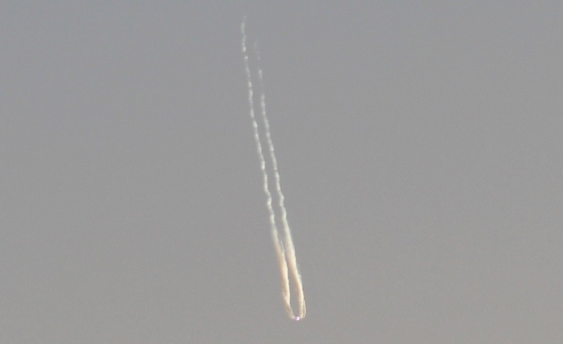
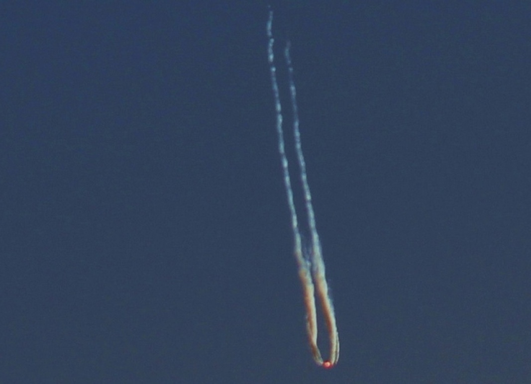
It look even more odd when the contrast and colors are adjusted, as is done on the version of the image most used in the news:


The following is copied from another post, but applies equally here.

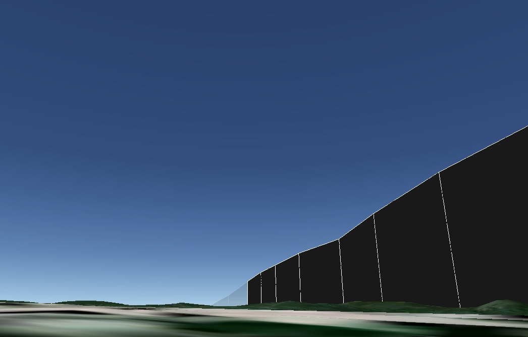
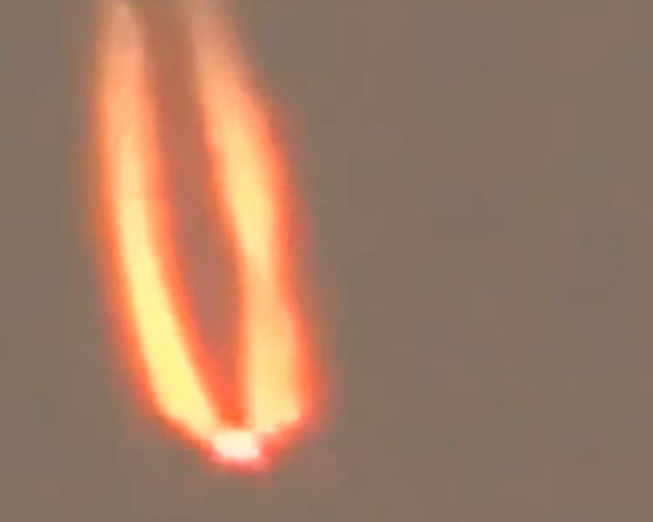
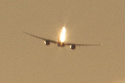
Judging by the size, position, time of day, and speed, I'd say it's a short sunlit contrail, with the plane also reflecting the set sun from over the horizon, the direct reflection giving a large flare. The shape of the contrail looks like it's from a 747


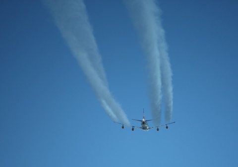
747 contrails for comparison. Note the distinctive twist.


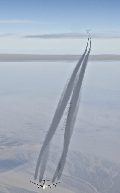
And here's an example of how even a small area of reflection can give quite a big flare:


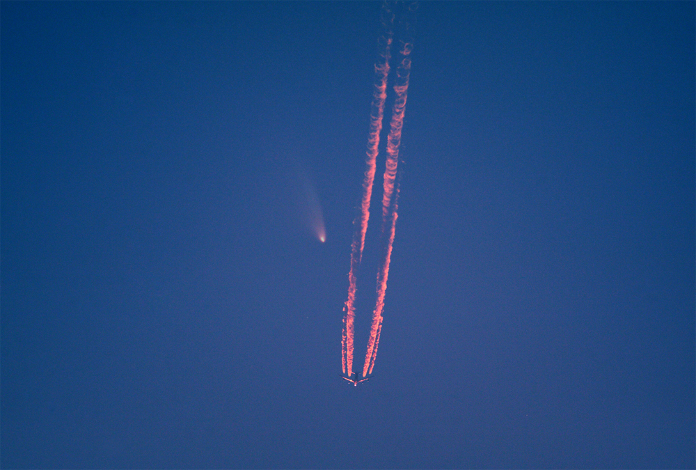
747 contrail with a comet in the background!
http://sagansense.tumblr.com/image/46129422515


Imagine this, but with the sun reflecting off the plane into your eyes:


See also:
http://contrailscience.com/short-sunlit-contrails-look-like-ufos/
 
Last edited:
Indeed, there was a B747 flying toward sunset at the time (4 PM of local time in Charlottetown, Labrador, N.L. is 20:00 UTC).
Screen shot 2014-11-22 at 13.23.13.png
Screen shot 2014-11-22 at 09.13.19.png

Edit:
There are two places called Charlottetown in the Canadian province of Newfoundland and Labrador, one in Labrador in Atlantic time zone (UTC-4), the other in Newfoundland in a different time zone (UTC-3:30). There were no planes flying near the latter at 4 PM local time. In contrast, there were three B747 passing by the former in a row: ELY7, VIR45W and BAW173, with the last one being the closest to the sunset.
 
Last edited:
The photo I use as my avatar is similar. Also a 747 (an Atlas Air cargo flight), but this one was flying towards me, away from the sunset.

atlasair.jpg
 
Astronomers agree:
http://www.northernpen.ca/News/Loca...948/Astronomers-agree-on-airplane-contrails/1

However, Chris Stevenson of the St. John’s Centre of the Royal Astronomical Society believes it was airplane contrails that Ward spotted.

For starters, Stevenson says a meteor only leaves one trail, not two trails behind. Secondly, Ward says the object was in the sky for one to two minutes whereas a meteor will move at such a speed that it can only be seen for a maximum of about five seconds.

He also noted the colour can be attributed to the way the sun reflects off of the object at the time of day with the sun setting, giving the plane a “fiery” appearance.

Even when the sun is set, he says, the object may still reflect the sun at that very high altitude. The appearance of the plane’s shape can be attributed to the angle at which it was seen – the dot being the end of the fuselage – while the appearance of the contrails vary a lot depending on the weather.

Randy Dodge, of the same society, agrees with this assessment, noting that when you zoom in on the object you can see four plumes indicating that it is a four-engine jet plane.

Using an aircraft tracker, he says it was likely Flight LH370 out of Frankfurt to Pearson Airport in Toronto or BA93 LHR out of London to Toronto, both of which passed over Charlottetown at that time.
Content from External Source

Yes, I have seen this already. Neither of their candidate flights was near the place on November, 17 at around the sunset (19:49 UTC).
 
Last edited:
Yes, I have seen this already. Neither of their candidate flights was near the place on November, 17 at around the sunset (19:49 UTC).

I suspect they might be a little confused about the time. The UTC thing often trips up first-time plane-finders.
 
I suspect they might be a little confused about the time. The UTC thing often trips up first-time plane-finders.
It is not about the time. It is about using the 'straight' lines between the two airports instead of actual flight tracks. Neither LH470 (LH370 is a local German flight), nor BA93 came near the place that day, or any other day of the past week.
 
I'd advise avoiding using GMT, as many people use it interchangeable with BST (British Summer Time) in the summer.

Yes..."BST" means "British Summer Time"

In the USA, it's "Daylight Saving Time". (This seems to have a bit of "creep" involved...IN THAT the dates when these "times" are implemented tend to "creep". I mean, the DATE of the 'shift').

There is the term "British 'Summer Time'" that I am familiar with....AND various other countries in Europe (or elsewhere) "shift" the "clocks" one hour....(In the USA the 'mantra' is "Spring forward, Fall back".....that's how WE remember it). Thing is, in Europe (for instance....the actual DATE of this "change" can vary. THIS is why, when I was flying, we'd see MANY different "Trip Pairings" (these are the schedules printed up, for crewmembers) when the dates of time changes varied....EVERYTHING in the airline "biz" is related to UTC of course....but for the "scheduling" part, there were aspects of the hours of duty involved. Makes it more "complicated").

AS far as I know this "tradition" was first implemented to help farmers.....it is a condition of the Northern hemisphere of this planet, and the way that as this planet orbits, with its axial tilt...the angle of the Sun lighting changes. ALSO....we (Humans) who have devised a time-based society....needed
to keep "tinkering". DESPITE the fact that the Earth orbits the SUN....and the length of every day varies, accordingly (depending on your physical location, meaning your actual Latitude location, ON the planet!!!)
 
Last edited:
It is not about the time. It is about using the 'straight' lines between the two airports instead of actual flight tracks. Neither LH470 (LH370 is a local German flight), nor BA93 came near the place that day, or any other day of the past week.


YOU may have just "cracked" it!

In actual aviation, we do not always fly "directly" in a straight line between each city-pair. There are High-Altitude routes to follow, with specifically designated (geographically) "waypoints".
 
The Northern Pen story does confirm it was in Labrador, and not on Newfoundland Island.

Now I've had a chance to look at FR24, I agree that BAW173 is the most likely candidate for a 4PM (20:00 UTC) Nov 17 sighting. KML file attached.

No street view, but at 19:51 UTC, BAW173 was just above the horizon:


Note the angle of the track does not match the apparent angle of the contrail, but this is easily accounted for with the wind coming from the north, and perspective foreshortening greatly exaggerating the apparent angle.
 

Attachments

  • FlightAware_BAW173_EGLL_KJFK_20141117.kml
    48.9 KB · Views: 954
The Northern Pen story does confirm it was in Labrador, and not on Newfoundland Island.

Now I've had a chance to look at FR24, I agree that BAW173 is the most likely candidate for a 4PM (20:00 UTC) Nov 17 sighting. KML file attached.

No street view, but at 19:51 UTC, BAW173 was just above the horizon:


Note the angle of the track does not match the apparent angle of the contrail, but this is easily accounted for with the wind coming from the north, and perspective foreshortening greatly exaggerating the apparent angle.

Blanche Ward probably lives not in Charlottetown itself but to the north of it, in Norman's Bay, where she would have a better viewing angle on the BAW173 contrail:
Norman's Bay view.jpg
 
Last edited:
Note the angle of the track does not match the apparent angle of the contrail, but this is easily accounted for with the wind coming from the north, and perspective foreshortening greatly exaggerating the apparent angle.

Here is an illustration to the above made with Google Earth.
BAW173 contrail.jpg
A highlighted section of the BAW173 track is about 11 miles long (just a bit more than one minute of flight). With a sufficiently strong wind coming from the north the contrail would deviate from the track by 6-7° (red line). Viewed from Norman's Bay (yellow pin with coordinates) the model contrail would have essentially the same apparent angle as the observed contrail.
BAW173 contrail from Norman's Bay.jpg
 
Here is an example of a real meteor(ite) (a screenshot from a BBC News videoclip):
Screen Shot 2015-09-07 at 12.59.37.png
'Fireball' streaks through Bangkok sky in Thailand

Car dashboard camera footage seemingly captures a meteor-like fireball blazing across bright blue skies in Bangkok, Thailand.

Footage courtesy of Porjai Jaturongkhakun
Content from External Source
Note the speed of the fireball crossing the sky compared to the sighting(s) of sunlit contrails.
'Fireball'-streaks-through-Bangkok-sky-in-Thailand---BBC-News.gif
 
Last edited by a moderator:
Back
Top