Oroville Dam Spillway Failure

Status
Not open for further replies.
By normal I am guessing that you mean the main spillway. The main spillway starts flowing water at 813 feet. At levels near 813 feet the flow iams low, increasing with higher lake levels.

Mick West said:
So the level of the lake should continue to fall overall, with only some minor pauses to rise. It's at 877 now. After the storm is over, worst case it will be at 857 feet.

So perhaps 3-5 days after the storm the levels will be too low for the main spillway. Decreases after that will depend on the power house and associated plumbing (ignoring evaporation). We hear that the power company has plans to fix the power lines fairly quickly, and it looked yesterday as if dredging was about to start. I guess we soon will be watching the helicopters dancing with power towers.
 
New member here. First, thank you all for your posts on this subject. Although most are above my head, I still would like to add something I found about earthquakes on the Cleveland Hills fault about the draining of Lake Oroville in 1975 for repairs and the subsequent earthquakes that were created when the lake was refilled. Our drought lowered the lake and has refilled this winter perhaps causing the same conditions. Could this be the trigger for the lower portion of main spillway crumbling?

http://www.johnmartin.com/earthquakes/eqpapers/00000052.htm

From the report:

SEISMICITY OF THE AREA

The location of Lake Oroville and the areal distribution of historical earthquakes and known faults are shown an figure 1. Three other earthquakes of M 5.0 to 5.9 have occurred since 1900 an or near the Foothills fault system within 60 km of Oroville. The first two occurred in 1909, 60 km east of Oroville (Toppozada and others, 1978) and the third in 1940, 60 km north of Oroville (Bolt and Miller, 1975). Thus, the occurrence of the 1975 M 5.7 earthquake within 70 km of Oroville was not without precedent.

Two factors suggest that Lake Oroville (maximum depth 220 m; storage capacity 413 billion m3) contributed to both the location and timing of the 1975 earthquake. The first factor is the proximity of the earthquake to the lake, and the extension of the causative fault to the lake as indicated by geologic, seismologic, and geodetic data (Department of Water Resources, 1979). This provides a possible avenue for water under pressure as high as 20 bars, resulting from a water depth of more than 200 meters into the fault zone (Lahr and others, 1976). The second factor is the occurrence of the earthquake following an unprecedented seasonal fluctuation in lake levels. This factor is illustrated in figure 2a, which shows lake levels (in meters above sea level) and number of earthquakes per month within 40 km of Oroville from 1964 to 1976. During the winter of 1974-1975, the lake was drawn down to its lowest level since filling to repair the intakes to the power plant. This unprecedented drawdown and subsequent refilling was followed by the earthquake sequence of 1975.


I also found there have been 2 micro quakes and 1 quake above the 2.0 (attributed to quarry blasting) over the last week.

Although the emergency spillway was originally built on “hard” rock could the earthquakes in the vicinity of Oroville since the dam’s creation be the cause of the fissures/faults in the “hard” rock?
 
Erosion of the main spillway might proceed up the hill. Worst case getting to the gates, or even taking out the southwest side and flooding down to the based of the dam. This worst case seems unlikely. The first worry is the powerlines just above the "waterfall"
The powerlines are non energized and PG&E expects them to be lost.
 
I have only seen cfs figures for releases... This again highlights the complications of communicating about science.
 
press conference now--they feel they can hold reservoir level as is with the first round of storms (i.e. it won't go back up); don't be surprised if they reduce the 100k cfs outflow when they can.

Did they say that? I'd suspect they would prefer not to change anything until they get the lake down to 850'
 
Did they say that? I'd suspect they would prefer not to change anything until they get the lake down to 850'
Croyle said a couple of times, "don't be surprised if you see it (reduced flows), don't worry if you see it". It seems they think the storms coming in won't raise the lake level and they can keep reducing it even at lower outflows, so that maybe they can get down to 850-860 even with the storms. I think he wanted to be very clear that if it happened people should not take it as a sign that the existing spillway is damaged. Maybe they will wait until they get to 850, but the fact he mentioned it here when it would be a couple of days to get to 850 even if no rain makes me think they'll try to reduce it sooner.
But he also said this is based on the current models they have for the weather and inflows and "there are error bars"...
 
One basic framing of this would be that (typically, not always!) erosion increases with CFS. It also increases with S=seconds=Time....the more volume and the longer duration the more erosion. Local , specific results will vary, it's not written in stone.
Do we have any indication that increasing the CFS on the main spillway would lead to more damage and erosion? I thought people were saying it's hitting bedrock?
 
If the spillways are constructed on a sheeted dike complex (1), the large variances in rock type associated with this type of formation combined with faulting, folding, and low T metamorphism that occurred during obduction will result in areas of bedrock more prone to chemical weathering than others. The steeply dipping beds will enhance the downward migration of meteoric water, exasperating this differential weathering pattern. Being situated hundreds of feet above the river has left this bedrock exposed to the elements for a million years more or less and has led to chemically weathered bedrock extending far below the surface in places while inches away horizontally is fresh bedrock.

Even worse would be if the spillways are built into the unit stratigraphically above the sheeted dikes, metavolcanics intruded by the dikes (1). Pillow lavas with their chill margins are fragile when fresh, and are even more susceptible to chemical weathering than the dikes.

Diabase might be an incredibly strong rock when fresh, but not all of the main spillway is built directly on this competent bedrock as is evidenced by the original blowout and images of the spillways construction. There are many sections of the main spillway directly below the gates that were built on chemically weathered bedrock. With a 100k cfs flowing for the foreseeable future, with higher rates possible considering the long range forecasts, another blowout is a real possibility.

The emergency spillway is not auxiliary, and i don't believe any competent geologist present during it's construction would have considered its use as anything but a last ditch effort. It was designed as a fail-safe to prevent the loss of the main dam during the event of up to half a million cfs inflow to the lake during a 200 to 1000 year event. The ogee weir extending from the main spillway gates was likely built to protect the main spillway gates. The bedrock was excavated deeper below the ogee weir to find more competent bedrock than the concrete wall extending northwards from the ogee weir, which was built to protect the ogee weir. The lack of concrete in the far NW corner of the parking lot where we saw considerable erosion and helicopters lowering bags of rocks into is not lack of foresight, but designed weakness built into a weak structure. The parking lot is built on highly weathered bedrock and is designed to function as a sacrificial plug located as far from the dam itself as possible, similar to the Auburn coffer dam failure of 1986. As headcutting progresses into the parking lot, water at elevation 900 and above is skimmed off. Once headcutting reaches the lake, then downcutting commences, "safely" lowering the lake till competent bedrock is found, maybe a hundred feet down, leaving the vast majority of the lake still in the lake and Oroville dam still standing, no matter the magnitude of the storm.

The costs associated with building a sound "auxiliary" spillway due to the amount of bedrock that needed to be excavated to reach the competent stuff, probably discovered after work had begun, could have led to such a design. In the event that the emergency spillway saw huge flows (not a mere 12k cfs), the flows would hydraulically mine out the weak bedrock so that a future main spillway and gates could be constructed that actually would stand the test of time. This was before water quality standards for fish was a concern.

Footage of helicopters ferrying in bags of rock is made for TV “look, we are doing everything we can” But the bedrock on either side of the ravine they were filling is just as weak as what had been washed out. If water were to return, downcutting would simply erode either side of the reinforcements or choose another channel to erode. The only way to make this emergency spillway an auxiliary with how things currently stand is to rock armor and concrete nearly the entire hilltop, which is what I expect to see done over the course of the next few weeks. But even then, without excavating out the weathered bedrock across the entire emergency spillway to a depth similar to the ogee weir closest the main spillway gates, a blowout similar to the original will be a real possibility.

(1)http://earth.geology.yale.edu/~ajs/1980/ajs_280A_1.pdf/329.pdf
 
Croyle said that the reason they would reduce outlet flow from the spillway has to do with the formed trough on the lake side of the flood control structure (main spillway) and the effect of the water flowing through it as the water level lowers. Perhaps because of the potential for erosion? He stated that was in their operating manual/protocols.
 
https://www.facebook.com/CADWR/videos/vb.95205192448/10154440265372449/

It's at 14:00 there.
"If we...continue to remove water from the reservoir at this 100,000 cfs rate then that can affect the rock conditions up front of the flood control structure, and we don't want to compromise that at all. There's a design model when they have reservoir elevation at certain limits they put limits on how much you can discharge at a certain time, and again we'll be stepping that down based on the reservoir water surface elevation to make sure that we operate within the design criteria of that flood control structure."

So basically as the lake level gets lower they need to reduce the flow - probably because it gets more turbulent in the channel behind the gates.

I believe this is the graph they will use:
20170215-134546-54j9i.jpg

I've marked 100K cfs, which is the recommended rate at 852 feet. Then down to 50K cfs at 838 feet, and all the way down to 5K at 820 feet

http://www.water.ca.gov/orovillerel...baCity_Levee Dst1_Appendices_Pages_10-177.pdf
(Page 107, "Oroville Spillway and Flood Control Outlet Rating Curves" 1963)
 
Last edited:
as a guess, and only a guess, and not a situation I'd care to make decisions based on guesses.
If the spillway is not eroding anymore (and I do mean anymore! like ZERO, requires measurements, scale? inch, mm, ) it's conceivable that spillway flow could be increased, perhaps substantially. The upper part of the spillway is currently intact, hopefully sound, and i think i recall, max concrete spillway flow is upward of 250,000cfs. (check this number!)
The crux of the matter would seem to be why has erosion stopped ? That's distinct from slowed down. Current concrete spillway stability is a godsend in this multi-variate situation. Different flows might produce different results. If the 100,000cfs currently is sufficient to achieve near term desired reservoir capacity, it seems prudent to continue with a stable regime. I believe the stated goal was a 50 foot ( =851' elevation) drop by Wednesday.
Testing other flows might be a possibility , were erosion to increase as a result (rate dependent... measure this!!! continuously real time!! even now) and stability decrease that would be a high consequence . It's also conceivable that given high inflow conditions, or other developing situations, it might be desirable, or essential, to increase outflow.....knowing that the spigot could be upped a bit , or a lot, might have some value.
Briefly, back to erosion, it might be worthwhile to go beyond merely measuring the location of the current erosion, but also measure (and I do mean measure!!!, tape , yardstick, photo from fixed safe, repeatable location, laser, GPS....all of the above?? ...real numbers required!!!) downslope , undercut or other soil and rock structures that are currently receding in order to give an early warning that the erosion is proceeding. Likely, if slippage above cutbank is observed even without failure, given flows and precip, it's fair to judiciously project that micro slice of terrain will heed gravity's urging. While keeping an open mind that one's projection may not occur , it might be a useful tool for erring in the direction of prudence.


One basic framing of this would be that (typically, not always!) erosion increases with CFS. It also increases with S=seconds=Time....the more volume and the longer duration the more erosion. Local , specific results will vary, it's not written in stone.
 
...
The same sort of pressure differential you get as a low pressure system runs by a region. It is not a lot, which is why a B-747 can get airborne.
...
And a water flow will do exactly the same as an airflow, which is how the hydrofoil boats that run between the Greek islands lift out of the water.

Just to reiterate; the Bernoulli effect is not how aerodynamic lift is generated, and it is not how hydrodynamic lift for planing craft is generated either.

Both generate lift as a reaction to displacing a medium (air, water) downwards.

[edit] I am hesitant to link directly, but Wikipedia has an excellent treatment of the subject on their Lift (force) page.
 
Last edited:
It sounds to me like they are describing the effect of reduced reservoir water mass on the underlaying or formally underlaying rocks i.e., "isostatic rebound"
Check me on this please water engineers. (after
https://www.facebook.com/CADWR/videos/vb.95205192448/10154440265372449/

It's at 14:00 there.
"If we...continue to remove water from the reservoir at this 100,000 cfs rate then that can affect the rock conditions up front of the flood control structure, and we don't want to compromise that at all. There's a design model when they have reservoir elevation at certain limits they put limits on how much you can discharge at a certain time, and again we'll be stepping that down based on the reservoir water surface elevation to make sure that we operate within the design criteria of that flood control structure."

So basically as the lake level gets lower they need to reduce the flow - probably because it gets more turbulent in the channel behind the gates.

I believe this is the graph they will use:
20170215-134546-54j9i.jpg

I've marked 100K cfs, which is the recommended rate at 852 feet. Then down to 50K cfs at 838 feet, and all the way down to 5K at 820 feet

http://www.water.ca.gov/orovillerelicensing/docs/FEIR_080722/AppendixA/Extracted_Comments/C0005_SutterCty_YubaCity_Levee Dst1_Appendices_Pages_10-177.pdf
(Page 107, "Oroville Spillway and Flood Control Outlet Rating Curves" 1963)
 
Obviosuly they can't release ANY water through the spillway when the lake level get below the sill of the main spillway (Flood Control Outlet), which is 813.6 feet. The lake level also limits how much water will flow through the gate, regardless of how open the gates are. They simply can't do more than a certain amount when the lake is low - not to avoid damage, there just isn't the head of water.
 
I request that further invocation of a Bernoulli concept provide a link to something which mentions its relevance to watercourses. Spillway design guidelines seem to not discuss it.
 
New member here. First, thank you all for your posts on this subject. Although most are above my head, I still would like to add something I found about earthquakes on the Cleveland Hills fault about the draining of Lake Oroville in 1975 for repairs and the subsequent earthquakes that were created when the lake was refilled. Our drought lowered the lake and has refilled this winter perhaps causing the same conditions. Could this be the trigger for the lower portion of main spillway crumbling?

No. There are several studies about Oroville Dam quakes, and any effects were minor. The dam may have settled (and become stronger) a little. One fault jiggled. I've found no mention of an effect on surface rocks. The effects on instruments in the dam were reported.

Notably, I have seen no mention of movement around the dam. For any project like this, there are a number of survey marks and I'm sure that they checked that nothing had moved. At present, there are three NGS GPS and height marks in the immediate vicinity of the dam.
 
thanks on this.
Is it a correct reading that, worst case , top 100' of reservoir flows out, dam preserved, below 801' elevation, remaining water retained, if all functions "safely"?
If the spillways are constructed on a sheeted dike complex (1), the large variances in rock type associated with this type of formation combined with faulting, folding, and low T metamorphism that occurred during obduction will result in areas of bedrock more prone to chemical weathering than others. The steeply dipping beds will enhance the downward migration of meteoric water, exasperating this differential weathering pattern. Being situated hundreds of feet above the river has left this bedrock exposed to the elements for a million years more or less and has led to chemically weathered bedrock extending far below the surface in places while inches away horizontally is fresh bedrock.

Even worse would be if the spillways are built into the unit stratigraphically above the sheeted dikes, metavolcanics intruded by the dikes (1). Pillow lavas with their chill margins are fragile when fresh, and are even more susceptible to chemical weathering than the dikes.

Diabase might be an incredibly strong rock when fresh, but not all of the main spillway is built directly on this competent bedrock as is evidenced by the original blowout and images of the spillways construction. There are many sections of the main spillway directly below the gates that were built on chemically weathered bedrock. With a 100k cfs flowing for the foreseeable future, with higher rates possible considering the long range forecasts, another blowout is a real possibility.

The emergency spillway is not auxiliary, and i don't believe any competent geologist present during it's construction would have considered its use as anything but a last ditch effort. It was designed as a fail-safe to prevent the loss of the main dam during the event of up to half a million cfs inflow to the lake during a 200 to 1000 year event. The ogee weir extending from the main spillway gates was likely built to protect the main spillway gates. The bedrock was excavated deeper below the ogee weir to find more competent bedrock than the concrete wall extending northwards from the ogee weir, which was built to protect the ogee weir. The lack of concrete in the far NW corner of the parking lot where we saw considerable erosion and helicopters lowering bags of rocks into is not lack of foresight, but designed weakness built into a weak structure. The parking lot is built on highly weathered bedrock and is designed to function as a sacrificial plug located as far from the dam itself as possible, similar to the Auburn coffer dam failure of 1986. As headcutting progresses into the parking lot, water at elevation 900 and above is skimmed off. Once headcutting reaches the lake, then downcutting commences, "safely" lowering the lake till competent bedrock is found, maybe a hundred feet down, leaving the vast majority of the lake still in the lake and Oroville dam still standing, no matter the magnitude of the storm.

The costs associated with building a sound "auxiliary" spillway due to the amount of bedrock that needed to be excavated to reach the competent stuff, probably discovered after work had begun, could have led to such a design. In the event that the emergency spillway saw huge flows (not a mere 12k cfs), the flows would hydraulically mine out the weak bedrock so that a future main spillway and gates could be constructed that actually would stand the test of time. This was before water quality standards for fish was a concern.

Footage of helicopters ferrying in bags of rock is made for TV “look, we are doing everything we can” But the bedrock on either side of the ravine they were filling is just as weak as what had been washed out. If water were to return, downcutting would simply erode either side of the reinforcements or choose another channel to erode. The only way to make this emergency spillway an auxiliary with how things currently stand is to rock armor and concrete nearly the entire hilltop, which is what I expect to see done over the course of the next few weeks. But even then, without excavating out the weathered bedrock across the entire emergency spillway to a depth similar to the ogee weir closest the main spillway gates, a blowout similar to the original will be a real possibility.

(1)http://earth.geology.yale.edu/~ajs/1980/ajs_280A_1.pdf/329.pdf
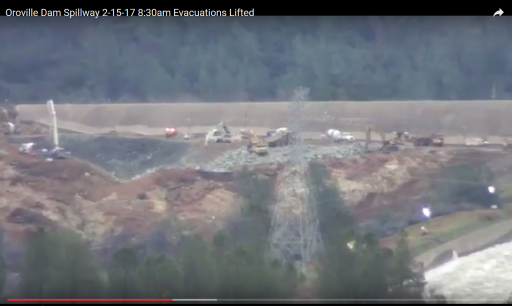
 
Is it only me who thinks that positioning of the two power line towers is faulty as being so close to the main spillway?
In case of emergency spillway use, there's still a chance that water flows to their direction and washes them out. In case they fall towards the main spillway, I'm pretty sure that creates some damage to the spillway concrete, just enough to initiate a crack.
 
The lack of concrete in the far NW corner of the parking lot where we saw considerable erosion and helicopters lowering bags of rocks into is not lack of foresight, but designed weakness built into a weak structure. The parking lot is built on highly weathered bedrock and is designed to function as a sacrificial plug located as far from the dam itself as possible,
and you 'know' this how?
 
[The crux of the matter would seem to be why has erosion stopped ?[/QUOTE]

Headward migration has encountered competent bedrock again. There are more zones of weathered bedrock underlying the spillway between the original blowout and the gates. The spillway may fail in another spot without needing to headcut its way up. I'm sure DWR is dreading the prospect of a tell tale rooster tail appearing closer to the main gates. They will have eyes on it 24/7, ready to close the gates at a moments notice.
 
Not to belabor a minor point, but both the 5cm depression and the earlier cite on the 5.7 quakes , and their probable cause are consistent with reservoir content having an effect (measurable in the first case) on underlaying rocks. Using conventional English , it appears the dam operations manual recognizes this also.
appreciate any clarity on clearing up my misread. Thanks.
 
Moderator Note - deirdre
Please remember Metabunk is an accurate, sourceable information forum. Please remember the 'outside readers' who are reading the thread for verifiable information. Be mindful of not making statements as if they are fact* unless you provide clear sources to back it up or these sources were posted previously.

*use modifiers such as "i imagine", "i think", "my guess would be.." etc unless you have documentation proving statements.
 
Just a few notes on the actual main spillway fracture plus two links on the oldest working dam in the world circa, 1309-1304 BC, showing its value for money. In my locality, a slightly newer dam built 1861.

I have reason to submit that the original fault in the emergency slipway has been caused by incorrectly angled concrete deck that caused suction due to release of compression as the water travelled downhill.

As one can see from the numerous photographs on this discussion, the angle of the slipway changes at about 40% down slope. The down flow of water under steady compression is forced to amplify speed causing the top 25-30% of down flow to increase speed thus causing a decompression or suction against the rest of flow. This suction at an estimated 200 metric tons per Square Meter would be sufficient to start a crack propagation phenomenon usually known as a subcritical crack. As it looks as if the concrete was not anchored via pilings etc at this area, the vertical stress would be sufficient to cause failure. Note that the failure is downhill of the actual angle change as it takes time for the decompression or suction effect to reach peak.

During a shear test, peak stress is located within the large strain zone at a strain value ɛf defining the material failure. Deviatoric peak stress qf, failure strain ɛf and the stiffness at very small strains are parameters needed to calculate both rigidity and degree of small strains.


ETan Very small strains

Esec

Eo

f

qf

q = ( a-r)


Failure ETan and Esec

Eo

0.1%

ETan

Esec

log

Large strains


Figure 1. Schematic stress-strain and stiffness-strain curves

for a natural soil (from Atkinson, 2000).


Non-linearity of soils. These are two parameters are used to determine the stiffness decay curve of soils (Atkinson, 2000). Rigidity is defined as the ratio of stiffness to strength (E/qf=1/εf) while the degree of non-linearity can be defined as the ratio of failure strain to a reference strain εf/εr. Using these concepts, Atkinson (2000) presented a simple non-linear stiffness-strain curve in terms of the tangent Young’s modulus Etan that is mathematically defined as:


Etan

E0=

1−εf

εr

1−εf

ε0r(1)


Where E0 is the Young modulus at very small strain for a strain ε0, εfis the strain at the peak Deviatoric stress

In addition, ris a soil parameter which includes the degree of non-linearity. According to Atkinson (2000), f saturated conditions, rcan vary from 0.1 to 0.5.[ii] I have used soil as it is the basic knowledge but the principle is the same for any particle however bonded.

The presence of water in building materials can lead to cracks which result from freeze/thaw cycles or, in combination with very low permeability's, to the spalling of high performance concrete exposed to fires. In addition, the invasion of water in building materials provides a mechanism and path for the penetration of deleterious materials like chloride and sulphate ions. While the primary transport mechanisms by which chloride and sulphate ions ingress concrete are diffusion and capillary action, diffusion alone can be a very slow process, hence it may be that capillary transport, especially near an unsaturated concrete surface, is the dominant invasion mechanism. Clearly, an understanding of moisture transport in concrete and mortar is important to estimate their service life as a building material and to improve their quality[iii]. As such, as this is an earthquake area, has the emergency slipway suffered cracks that were actually deeper than known.

Several posts have noted that there may have been cavitations[iv] that may have or presumably did cause shock waves, which would have occurred under the down flow angle, change as noted.

To fix the problem in the future;


http://www.icevirtuallibrary.com/doi/abs/10.1680/geot.2003.53.2.289?journalCode=jgeot

[ii] https://www.researchgate.net/publication/277677537_Suction_effects_on_the_pre

failure_behaviour_of_a_compacted_clayey_soil

[iii] http://ciks.cbt.nist.gov/~garbocz/captrans/node1.html

[iv] https://en.wikipedia.org/wiki/Cavitation

This is the best theory I have come across explaining the original Main Spillway failure. "Sailing Mark", could you please rewrite the portion of your post that deals with the spillway failure in less technical, more accessible way? Thank You. P.S. If you don't mind sharing, what is your profession?
 
I have a question about the hillside just below the newly constructed road by the emergency spillway: won't it erode quite a bit under heavy rains?

Since there is so much exposed topsoil and already gulleys formed, won't the rainfall create streams which make the gulleys a bit deeper and thus take away a bit more of the ground support which helps to prop up the weir section of the dam (immediately adjacent to the emergency spillway?)

Put it this way, I live in England and even a small storm which lays down an inch of rain in a day will cause even the smallest streams and gulleys to roar with water in the hills and mountains. Throw in all the exposed top soil and there is a danger of small mudslides and possible scouring close to the temporary road. It won't come close to the discharge that happened last Sunday and Monday, but still... The engineers need every bit of the emergency spillway they can and extra erosion will not help their task.

Heavy rainfall will not help erosion around the newly formed cliffs -- the ones by the main spillway -- either...

Given this why aren't there dozens of concrete mixers and hundreds of dumper trucks patching up the entire section of eroded emergency spillway? Why hasn't it been done before these new sets of storms arrive?
 
Last edited:
I have a question about the hillside just below the newly constructed road by the emergency spillway: won't it erode quite a bit under heavy rains?


i'd imagine rain erosion is last on every bodies list right now. totally irrelevant ... its the foot of the weir and immediately downstream thats the priority and not for rain... but for some odd # of 1000's of cuft going over the wall.
 
Scott, you appear to have forgotten the culverts/drains, without them you would have water dammed up and finally undercutting your roadway.
Nope ... there IS a small drain for the basin between weir and new haul road. But it is primarily for rainwater I suspect.

Culverts cause concentration which causes erosion.

The whole point of a weir wall like this is maintaining laminar flat flow over the area ... all flowing in one uniform depth and one direction - a flat, uniform sheet - so there are no concentrated flow points to begin erosion. The best way IMO would be to make the top bench below weir flat all the way across ... same with slope down to the road. Harden the bench, the slope to the road, the road base and the slope down from the road .... then let water take its course down the hillside - which we've seen can easily handle the flow ... being largely blue/green bedrock
 
Thanks,
Hmmn, guess it's time for a calculation on top 100' of reservoir capacity, just to file back in the databanks. That takes some of the uncertainty out of things.
Very much appreciate your ultra clear geologic descriptions.
Thanks metabunk,
Lastly, anybody find any ultra-clear late afternoon/ early eve imagery? Somehow the idea of high resolution infrared, perhaps even low resolution infrared imaging keeps kicking around in my head as a potentially useful tool to get an early jump on fugitive water flows....probably work well at night too.
 
You know, I went back and read the motion in the 2005 FERC proceedings. Turns out that the distinction between an emergency spillway and an auxiliary spillway is actually dam important.

In that context, it is very of odd that the DWR guys were using the term interchangeably.

If they'd called it an auxiliary spillway back then, they likely would have needed to put in the cement.

As you point out, an emergency spillway is really only intended to save dam integrity, not for general flood control purposes. An auxiliary spillway on the other hand is one that might be used occasionally for flood control, and is supposed to be sturdier and better engineered than an emergency spillway.

The big issue in the motion in the FERC proceeding was the claim that the DWR would use the e-spillway as an auxiliary spillway, and thus should engineer it to the higher standard. The fear was that DWR would be tempted to use it not to save the dam, but instead to protect its own facilities, like the main service spillway. Which, it turns out, is what the DWR did in this case. Rather than continuing to run the main spillway at 100kcfs after the damage was discovered, DWR chose to slow it down, requiring use of the e-spillway.

The use of the emergency spillway was not an auxiliary use. It was put into use because of an emergency prompted by damage to the main spillway.

I think your find is a good catch - but in this case use as an auxiliary to the main is still emergency use
 
Status
Not open for further replies.
Back
Top