
You are using an out of date browser. It may not display this or other websites correctly.
You should upgrade or use an alternative browser.
You should upgrade or use an alternative browser.
Oroville Dam Spillway Failure
- Thread starter Mick West
- Start date
-
- Tags
- oroville dam
- Status
- Not open for further replies.
Excellent work and photos people.
Geologic maps (plan view), as posted, are what's at the surface , geology is 3d. Somebody said "Geologists are people who think they can see through rock". Cross sections provide an interpretation of a defined slice and may be better defined if additional information including from bore holes, drilling logs, tunnels and other sources is incorporated. I don't know what process was used here, or the general geologic input on critical infrastructure, but I'm assuming they looked very carefully. That doesn't mean complete knowledge and it doesn't mean conditions have not changed.
It appears, that the reddish areas are soils and subject to erosion (to what depth?) based on what we've witnessed at the main spillways and the muddy runoff (that's mass removal from the hillside. That's not coming from over the dam). Drawing down the reservoir is fantastic. With no flow over the spillway, any other flow has to be coming from somewhere else and this allows them to look for this. The soils still hold plenty of water and will continue to drain, but I'd guess that flows larger than this will get scrutiny.
The aux spillway has been tested at very low flows now. What are the results?
The eroded main spillway is also being tested at 100,000cfs and those results are important too. If higher flows can safely be dumped through that damaged spillway that's a huge and welcome tool for managing flows through this season. We're just seeing the benefits of drawing down the reservoir (no more aux spillway flow, recession of shoreline below the parking lot, less pressure up high on the aux spillway , which will lower or eliminate any flow that might have possibly found a path, preservation of aux spillway for future flows if necessary....those are some that come to mind
Rock type matters and is important , fractures, joints, adjacent rock types, soils, topography ...also matter. A post above mention, if I recall, "....if moderately protected..." in reference to the spillway site. Perhaps implicit here is that the evaluator at the time considered it solid and subject to improvement. Likely steps were taken....don't know what was required , thought needed or done. The excellent early photos showing the rock in the main spillway channel does show an aligned joint or fracture pattern....It's visible from the air photo! This is a good illustration of one type of feature that might influence flow and even susceptibility to erosion.
sorry for being so wordy.....a realm that were now in is geomorphology and landscape management, which I'd guess is outside the handbook of standard dam management. If the site thought to be the boil, at the cut in the bend in the roadway cut farther towards the main spillway that likely would be considered a concern. It appears there is buried rock between the two from the photos. The competency of that division is likely important. Topology will effect spillover flow and might possibly be a friend if water ate towards that. Given a preferred path, which in a pinch, it might be possible to induce, water will choose the easier path meanwhile creating a new topology.
KCRA chopper reporter said about half an hour ago that he'd noticed fresh erosion on the NW side of the hole which now looks like a large waterfall. Likely there's some head-cutting going on (undercutting the lip of the waterfall, the top edge of the hole). The ground on either side of the hole there looks like dirt, not rock. But we can't see what's directly under the remaining undamaged spillway

Bleodswean
New Member
KCRA chopper reporter said about half an hour ago that he'd noticed fresh erosion on the NW side of the hole which now looks like a large waterfall. Likely there's some head-cutting going on (undercutting the lip of the waterfall, the top edge of the hole). The ground on either side of the hole there looks like dirt, not rock. But we can't see what's directly under the remaining undamaged spillway
Obviously speculative, but if this new cavity goes right, demolishing what remains of the spillway and then up and over that large piece of bedrock, towards the dam/powerhouse, aren't we going to lose the powerhouse?
Rob Shearer
New Member
Here are side-by-side shots of the Main Spillway from the CDWR galleries, showing how much damage was done in the 48 hours from Feb 7 to Feb 9.

Obviously speculative, but if this new cavity goes right, demolishing what remains of the spillway and then up and over that large piece of bedrock, towards the dam/powerhouse, aren't we going to lose the powerhouse?
There's really no way that would happen unless the entire ridge collapses at which point all is lost. Does not seem at all likely
(Vertical 2x for perspective)
apologies for misunderstanding protocol and reposting.
last point, looking at the new chopper photo of possible new erosion on the main spillway.
It appears there's a muddy flow from above and on the west side . What's the source for that flow? I expect flows of muddy water, particularly larger ( no definition of larger) are of interest. Source matters.
Vicki W
New Member
Thank you for the great information. I am certainly just a learner when it comes to geohydrology! If I recall (and again this is me relying on my own historical memory) some of our levee breeches were not overtopping but were structural failures (boils, seepage and then cracking).
Here is some verbiage I found talking about Twin Cities history (twin cities being Marysville and Yuba City in this case).
"The 2007 assessment by the Army Corps of Engineers found 125 observed "levee performance problem locations" on the Feather River since 1955. The problems include seepage, erosion, boils, breaks and cracks. The study concluded that a levee failure at any one of the problem locations could cause flooding with a depth of one foot to over 20 feet."
And then in 2013 "The primary risk of flooding in the Sutter Basin has been determined to be geotechnical failure of the existing project levees, and not hydrological or hydraulic factors that result in levee overtopping." (there is some commentary about how 86 and 97 were more a result of underseepage.
(Page 8) http://www.usace.army.mil/Portals/2/docs/civilworks/CWRB/sutter/sutter_projsum.pdf
Obviously, we have a much larger problem than the levees, but this is a bag of adders with so many complicated aspects making the situation treacherous.
Of course none of this matters if we can't get the spillway and auxillary spillway under control.
2007 Army Corp report: http://www.water.ca.gov/levees/links/docs/2007BankErosionReconnRpt.pdf
apologies for misunderstanding protocol and reposting.
last point, looking at the new chopper photo of possible new erosion on the main spillway.
It appears there's a muddy flow from above and on the west side . What's the source for that flow? I expect flows of muddy water, particularly larger ( no definition of larger) are of interest. Source matters.
I don't think that's a flow, it's just where the hillside has collapsed. The perspective makes it look like it's on the hill.
I'm an engineer/scientist (electrical/atmospheric) and I find this thread absolutely fascinating. Should be required reading for every news organization and politician, and Mick West is to be commended for public service. After reading the thread and then watching the national news and clips from the local news, it really gives you perspective about the importance of appropriate knowledge and communication.
Eric Hubbard
New Member
I'm an engineer/scientist (electrical/atmospheric) and I find this thread absolutely fascinating. Should be required reading for every news organization and politician, and Mick West is to be commended for public service. After reading the thread and then watching the national news and clips from the local news, it really gives you perspective about the importance of appropriate knowledge and communication.
100% agree.
I don't think that's a flow, it's just where the hillside has collapsed. The perspective makes it look like it's on the hill.
View from the side just now. It's getting dangerously close to the power lines
2min later
SFX
Member
Since they aren't going to stop the flow down the damaged spillway, we will actually find out what is under the ground there. 35,000 cfs did a ton of erosion, 50,000 cfs really ate it up, and now with 100,000 cfs we can see a preview of what is going to happen if a 1,000,000 cfs goes down the emergency spillway hillside. (it might be 5 million, who knows?)
The real problem is the most damage will happen right next to the reservoir, not down the hill. It's certainly a real problem. If the damaged spillway can be used at the maximum flow for the next few weeks, it might not be that bad.
As long as it doesn't eat it's way up to the reservoir.
It's a damn shame, with all that water being so important to keep around.
Press conference coming up any minute
http://www.nbcbayarea.com/news/loca...vel-Drops-After-188K-Evacuated-413594893.html
http://www.nbcbayarea.com/news/loca...vel-Drops-After-188K-Evacuated-413594893.html
SFX
Member
But now there is an actual waterfall at the end of the spillway, so it's eating down as well. That amount of water is going to destroy anything by undercutting if they keep letting that much water out. By "end of spillway" I mean where there is no longer any spillway.Current damage vs. original damage. It has gone up the hill about 300 feet in six days (mostly with lower flow)
Unless there is a lot of solid rock that can resist the water, it is going to just keep eating under and breaking the rock by fracturing. Hopefully there will just be a huge waterfall that won't destroy the entire structure before the rain stops and the snow melts.
It's pretty dire.
But now there is an actual waterfall at the end of the spillway, so it's eating down as well. That amount of water is going to destroy anything by undercutting if they keep letting that much water out. By "end of spillway" I mean where there is no longer any spillway.
Unless there is a lot of solid rock that can resist the water, it is going to just keep eating under and breaking the rock by fracturing. Hopefully there will just be a huge waterfall that won't destroy the entire structure before the rain stops and the snow melts.
It's pretty dire.
Looking at where those ridges are though, it seems like at some point it's going to hit where the spillway is laid more or less directly on rock (i.e. where they had to cut into the rock), and that that point it will stop head-cutting.
Unfortunately that might be a bit past where the pylons are.
Starting now.Press conference coming up any minute
http://www.nbcbayarea.com/news/loca...vel-Drops-After-188K-Evacuated-413594893.html
Bill Croyle, DWR:
- Lots of monitoring of the situation
- 100K CFS for the last 17 hours.
- Looking towards dealing with spring runoff.
- Inflow at 9AM was 37,000 CFS
- Forecast for coming storm is less water than the previous system
- Focus on developing flood storage (i.e. emptying the lake as much as possible)
SFX
Member
We hope so. The problem is how far the water is falling off the end of the spillway. That adds a huge amount of cutting force to the water, and unless the rock is really solid, it will keep fracturing the rock, allowing it to fall. It doesn't have to erode the rock, just a crack is all it takes for water to start eating away at the structural integrity of the hillside. The weight of the water and rock above the cut will do the rest.Looking at where those ridges are though, it seems like at some point it's going to hit where the spillway is laid more or less directly on rock (i.e. where they had to cut into the rock), and that that point it will stop head-cutting.
I do not like this at all.
stuart little
New Member
what happens when the powerlines go at the damn... looks like they will be gone soon
do problems compound when those powerlines go?
do problems compound when those powerlines go?
Last edited by a moderator:
hi just signed up to ask what happens when the powerlines go at the damn... looks like the will be gone soon
Powerlines supply power to the power station, open the valves for the generators, currently they are not used, so it would make no difference.
However I'm not sure what powers the main spillway gates.
I think they may make it past the immediate crisis by spilling water at 120k cfs for 72 hours. However, the "rebuild" bill has magnified immensely, as they will be required to design a cement lined emergency spillway capable of >200k cfs.
Yeah, might be getting up towards $1 billion, which is what a brand new spillway cost at Folsom, which is a lot smaller.
Bleodswean
New Member
Coyle was asked why the emergency spillway failed at 10K when designed for 100s. Said something about lower flows sometimes cause more damage. Kind of waffled around the issue. Looks understandably tired.
He looks exhausted. Very different from Tuesday night last week. BUT, I understand what he's saying in regards to the flow level. What I don't understand is how this acting director could have ZERO knowledge of the report from ten years ago?
SFX
Member
This image shows what I am concerned about.
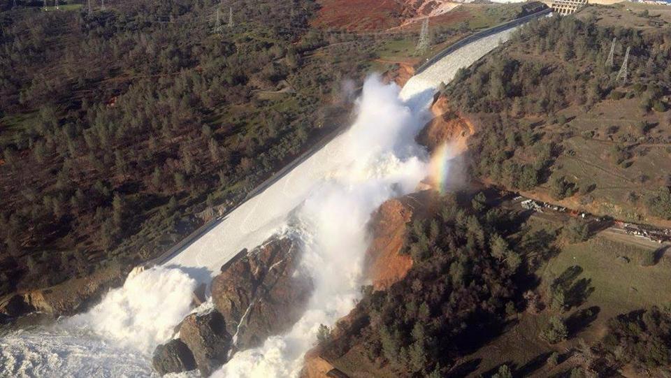
http://www.hindustantimes.com/world...evacuations/story-qz9KmhHNpH71OwFHGxkBYJ.html
There is already at least a 300 foot waterfall, and it is going to only get worse. The force of the water falling before it hits really increases the damage it will do.
The farther it moves up, the farther the water is going to fall, causing an increase in the speed of undercutting of the cliff face.
It's hard to tell, but it might be a 400 foot fall now. In any case, that seems to be the most pressing danger to the reservoir. The dam might hold, but if that cuts back to the actual reservoir, it's all over.
PhyllisO
New Member
I completely agree. It is very heartening to see all this brainpower and goodwill.I'm an engineer/scientist (electrical/atmospheric) and I find this thread absolutely fascinating. Should be required reading for every news organization and politician, and Mick West is to be commended for public service. After reading the thread and then watching the national news and clips from the local news, it really gives you perspective about the importance of appropriate knowledge and communication.
This image shows what I am concerned about.
http://www.hindustantimes.com/world...evacuations/story-qz9KmhHNpH71OwFHGxkBYJ.html
There is already at least a 300 foot waterfall, and it is going to only get worse. The force of the water falling before it hits really increases the damage it will do.
The farther it moves up, the farther the water is going to fall, causing an increase in the speed of undercutting of the cliff face.
It's hard to tell, but it might be a 400 foot fall now. In any case, that seems to be the most pressing danger to the reservoir. The dam might hold, but if that cuts back to the actual reservoir, it's all over.
Again though, once the loose material is removed, the rock can withstand a lot. For comparison, one of the fastest moving waterfalls is Niagara Falls, which is 187 feet high and has moved seven miles in 12,500 years (3 feet per year).
Vicki W
New Member
I found the press conference to be adequate in terms of information, but would like to see images and explanation of images. As for waffling on the auxiliary spillway, I'm not surprised. No one would know much about how it would operate.
One out standing question that I have is why the auxiliary spillway has concrete coping for only the lateral 2/3rds, but not on the section closest to the main spillway? It seems that the area that didn't have the coping has sustained the most erosion.
One out standing question that I have is why the auxiliary spillway has concrete coping for only the lateral 2/3rds, but not on the section closest to the main spillway? It seems that the area that didn't have the coping has sustained the most erosion.
He looks exhausted. Very different from Tuesday night last week. BUT, I understand what he's saying in regards to the flow level. What I don't understand is how this acting director could have ZERO knowledge of the report from ten years ago?
He's only held this position for two months. Tough start.
EricL
Member
New member here. First, I want to say it's refreshing to see such a thoughtful discussion being led by Mick.
I'm not expert on any of this, but just for some background, I have worked as an engineering tech in the realm of foundation soils for close to 25 years. As such, I've been appalled by the ignorant commentary on many sites other than this one.
Second, I have just a few general comments, to which I'd welcome any feedback.
There's been a lot of talk about a "boil" being observed below the emergency spillway last night, but I'm having real doubts that that's what was seen. Clearly there's been some deep, localized erosion, but if a boil had developed, I really think it would still be active, and here's why. Any water which had somehow leached through the soil below the concrete lip of the emergency spillway to the point that there was enough upward/outward pressure on the downstream side to lift that soil and then move with significant flow, this would result in a pathway through the soil where the soil had been displaced and severely weakened. If such a boil occurred at the base of one of those deeper holes, well, I don't know how deep they are - 20 feet? - then the new hydraulic head would be roughly 0.9 of that occurring last night, and once a weakened pathway had developed through the soil below that spillway lip, I can't see that such head reduction would stop the flow. I suspect that some reporter used the word "boil" to describe an area of concern, and things took off from there. As I write this, I'm missing the current official update, and maybe they will say something about it.
On the topic of reporters getting things wrong, note that for the official-update website, the reporter who wrote the introductory remarks said that last night there were concerns that a "30-foot wall of water" would go rushing down the river valley. Well, that wasn't what any of the officials said. The officials were concerned that they might lose as much as the top 30 feet of some portion of the lip of the emergency spillway. That would cause the lake to quickly drop 30 feet, but how fast the water actually exited would depend on the size of the hole. A small hole that's 30 feet deep would release water much more slowly than if the whole emergency spillway dropped by 30 feet. As long as the hole in the spillway lip were significantly smaller in cross section than the cross section of the river valley below needed to carry that flow, you wouldn't get "a 30-foot wall of water" gushing down the valley. This is a perfect example of how reporters tend to get things wrong.
On a similar note, last night, one poster made a comment which I don't think that Mick addressed, suggesting that the designers probably knew that the dam as a whole (referring particularly to the area of the emergency spillway) could not tolerate being full to the brim for more than a very short time, and the poster suggested that this was probably what caused things to fail. Since that post hasn't been addressed, I will. There has been no bursting type of failure so far, that I've seen evidence of or heard about. All the damage has been on the downstream face, caused by erosion. In regard to resistance to bursting, and also resistance to "boils", the designers would have made the structure thick enough to prevent that, then applied a safety factor, probably a very generous one. In some of the older photos taken during construction and later when the lake level was lower than now, you can see how great the horizontal thickness of earth is near the top of the emergency spillway. Of course, that varies with elevation because of the very gentle downward slope toward the lake on the upstream side, but it looks like within the upper 20 feet or so of lake level, there would be hundreds of feet in horizontal thickness, with the concrete lip of the spillway on the downstream face of that broad thickness of earth. That hardly seems like a failure-prone design, from a bursting standpoint, as such a massive amount of earth won't be affected by the minor static force applied by water in that upper zone (say, within the upper 20 to 30 feet) when the lake is full. Again, comments regarding this are welcome.
Again, my compliments on a good site. This is the second "debunking" site I've found in a week, and I'm so encouraged by that, and I'm really pleased with the nature of the discussion here.
Last edited:
This image shows what I am concerned about.
http://www.hindustantimes.com/world...evacuations/story-qz9KmhHNpH71OwFHGxkBYJ.html
There is already at least a 300 foot waterfall, and it is going to only get worse. The force of the water falling before it hits really increases the damage it will do.
The farther it moves up, the farther the water is going to fall, causing an increase in the speed of undercutting of the cliff face.
It's hard to tell, but it might be a 400 foot fall now. In any case, that seems to be the most pressing danger to the reservoir. The dam might hold, but if that cuts back to the actual reservoir, it's all over.
Here are two pictures of the New Bullards Dam and Spillway. It is about 20 miles away and opened in 1969. You can see that the water after leaving the concrete portion of the spillway has eroded down to bedrock and created a stable fan shaped path to the river below. It is my guess/hope that this is what the main spillway at Oroville will stabilize to.
There's been a lot of talk about a "boil" being observed below the emergency spillway last night, but I'm having real doubts that that's what was seen.
I think by "boil" they just mean a pocket of high energy water where it's hitting an obstruction and bouncing around, like in a whitewater situation.
http://www.pinnacle-travel.org/whitewater-rafting-glossary/
http://www.russellfork.info/descrgorge.htmExternal Quote:Boil Line: The line below vertical-drop reversals above which the surface current moves back upriver into the falls and below which the surface current moves off downriver. Also called a "boil zone" because often this "line" is a broad zone of white, bubbling, upwelling water much of which is merely "boiling" in place while some is moving upriver and some downriver.
Photo of a boil:External Quote:
o get to the main line (Class V-V+), get into the large eddy on river left above the lip of the drop. From this eddy, you'll paddle hard toward the river right edge, boofing hard over the lip. If successful, you'll land on a boil of water between a)a huge hole, b) a large clam shaped boulder and c) a micro eddy that sucks to be in. Paddle hard to the right of the boulder punching a couple of holes to get out.
- Status
- Not open for further replies.
Similar threads
- Replies
- 19
- Views
- 6K
- Replies
- 3
- Views
- 7K
- Replies
- 42
- Views
- 7K