Bags of large rocks, yes.so they will be dropping large rocks into that boil/hole ??

You are using an out of date browser. It may not display this or other websites correctly.
You should upgrade or use an alternative browser.
You should upgrade or use an alternative browser.
Oroville Dam Spillway Failure
- Thread starter Mick West
- Start date
-
- Tags
- oroville dam
- Status
- Not open for further replies.
Assuming all goes well with the plugging the hole, and the continued reduction in the lake level, here are the upcoming issues:
- 16,000 people have evacuated Oroville, there are also evacuations in Yuba county and other places downstream. I've seen numbers over 100,000 people. They can't all stay in the fairground in Chico. They probably can't go back for at least 24 hours.
- Massive increase in the outflow to the main spillway to 100K cfs might either damage that spillway, or take out a power line.
- 100K cfs, while not too high, is going into already swollen waterways, some minor additional flooding
- Storms arrive on thursday, so they have to keep up the 100K if possible to make room.
- When the water stops on the emergency spillway they have to work round the clock to solidify it. A massive undertaking.
-It's unclear to me how the emergency spillway is constructed. It's not sitting on bedrock?
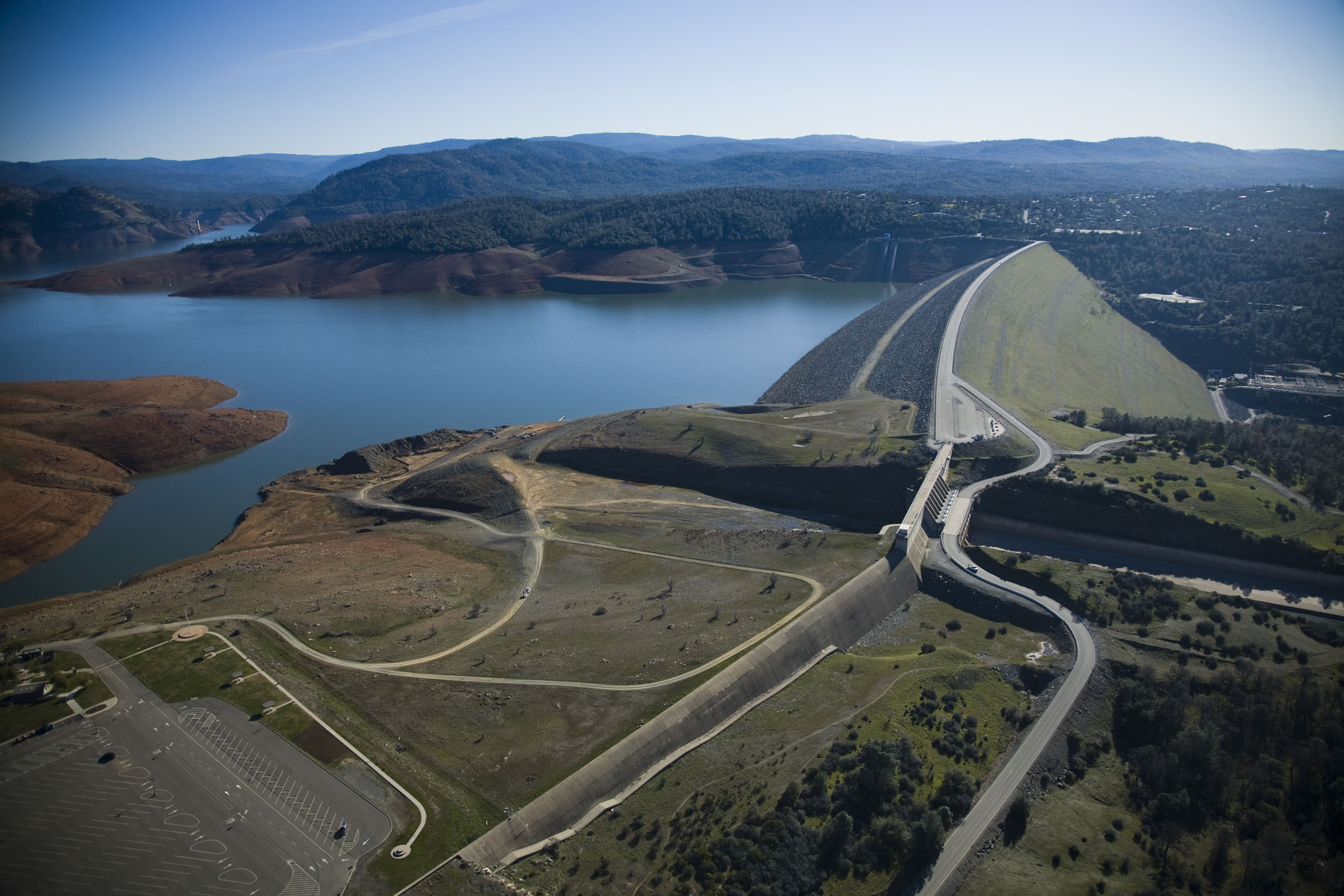
No, it's a concrete weir at the top of the hillside, and then the hillside. Build in the 1960s and never used.
-Is the power plant currently hooked up to the grid?
It's switched off - not running any generators. It is hooked up in that there's power going in, which is needed to operate the valves (which are currently closed)
It looks like the overflow should be stopping around now:
http://cdec.water.ca.gov/cgi-progs/queryF?s=ORO

That 0 outflow is a glitch, about the time they went to 100, you can see that in the River outflows in the next column
They will probably continue the 100K cfs indefinitely, as they also want to reduce pressure on the weir.
http://cdec.water.ca.gov/cgi-progs/queryF?s=ORO
That 0 outflow is a glitch, about the time they went to 100, you can see that in the River outflows in the next column
They will probably continue the 100K cfs indefinitely, as they also want to reduce pressure on the weir.
-It's unclear to me how the emergency spillway is constructed. It's not sitting on bedrock?
That's suddenly become the million dollar question! "What are those hills make of?"
You can see solid rock at the base of the main spillway, but there's also plenty of topsoil and loose rock visible from assorted satellite images. I'm guessing there is bedrock not too terribly far beneath the topsoil. They designed the e-spillway to handle a Godzilla-sized flood, and presumably located it where it is for a good reason.
Z.W. Wolf
Senior Member.
No, it's a concrete weir at the top of the hillside, and then the hillside. Build in the 1960s and never used.
So it's like a concrete sidewalk, or maybe a curb is a better analogy, sitting on dirt. Erode the dirt away from under it, and it goes. So how far down is the bedrock?
And why, oh why is the whole area below not covered in concrete - or, failing that, large boulders?
So it's like a concrete sidewalk, or maybe a curb is a better analogy, sitting on dirt. Erode the dirt away from under it, and it goes. So how far down is the bedrock?
And why, oh why is the whole area below not covered in concrete - or, failing that, large boulders?
Because they thought it would be fine.
The rock isn't that far down, but it's not like it's a flat rock surface under some dirt. It's some craggy rock, as you can see exposed at the bottom of the main spillway
So when the engineers see what looks like a hole forming in the ground in front of the spillway they don't exactly have 3D maps of the underground to hand, so they have to assume that maybe there's some non-bedrock regions under there. Hence they order an evacuation and arrange for helicopters to fill the hole with rocks.
There's a good possibility that the spillway is well tied into the bedrock at the top of the hill. However it's not something you want to chance, seeing as there's no way of knowing for sure, and hundreds of people might die if you get it wrong.
Carl Leoanrd
New Member
There is no way that the e-spill weir is not built on bed rock. It would have failed long ago. The question is the integrity of that rock.
Last edited:
Bleodswean
New Member
Things have been CRAZY here. I hope all our locals are okay, safe, and out of the chaotic panic.
It sounds as though the "imminent" danger has passed. Now what to do with all the evacuees...
ETA - Again, this forum is just utterly humbling and amazingly informative. Our local newscaster actually said around 6:15 "Let's all hope and pray that the dam holds." On air. Live.
It sounds as though the "imminent" danger has passed. Now what to do with all the evacuees...
ETA - Again, this forum is just utterly humbling and amazingly informative. Our local newscaster actually said around 6:15 "Let's all hope and pray that the dam holds." On air. Live.
There is no way that the e-spill weir is not built on bed rock. It would have failed log ago. The question is the integrity of that rock.
Yeah, by "non-bedrock" I mean something other than good solid rock.
Whitebeard
Senior Member
Found thisThat's suddenly become the million dollar question! "What are those hills make of?"
https://www.geocaching.com/geocache/GC1BZ9C_table-mountain-basalt
Don't mean much to me, but thats cos my knowledge of geology is pretty weak to say the least. Maybe some one more enlightened could put that in lay mans termsExternal Quote:Local Oroville Geology:
The geology of the Oroville area is fascinating. Oroville sits on the eastern rim of the Great Valley, defined today by the floodplains of the Sacramento River and its tributaries. Around Oroville these sediments are dominated by thick fans of Feather River sediments, but just east of this there is a thin, N-S band of late Cretaceous sediments. These sit on top of the Sierran basement, which beneath eastern Oroville comprise greenschist-facies metavolcanic rocks of Jurassic age, giving way to granites of the Sierra batholith to the east. These are manifestations of a vigorous island arc sequence, built out over an east-dipping subduction zone of mid- to late Mesozoic age. The gold veins lace this ancient arc, remobilized by Mesozoic shearing and intrusions of igneous rock. The crystalline foothills are locally overlain by a Cenozoic sequence of Eocene clean beach sands overlain by Neogene volcanics, including the Diamond Head-like profile of Table Mountain
And for the hardcore rock fan there is this document which may give more detailed info
https://archive.org/stream/geologyoforovill00creerich/geologyoforovill00creerich_djvu.txt
Manuel Haas
New Member
According to the lake's live data, the inflow has decreased by more than 50% over the last hour. (20.00 to 21.00)
Seems like the rocks transported to the dam could have been used to block some of the incoming water to temporarily slow down the process.
-----------------------level capacity out CFS in CFS
02/12/2017 16:00 902.09 3570722 65117 41410 72238 34.76 13.4
02/12/2017 17:00 901.89 3567540 0 45998 97713 34.76 13.3
02/12/2017 18:00 901.65 3563726 99969 42369 103022 34.76 13.5
02/12/2017 19:00 901.35 3558960 99758 40485 113169 34.76 13.5
02/12/2017 20:00 901.02 3553726 99658 37441 118405 34.76 13.5
02/12/2017 21:00 900.70 3548654 0 14784 118144 34.76 13.3
source:
https://cdec.water.ca.gov/cgi-progs/queryF?s=ORO&d=12-Feb-2017+21:07&span=25hours
Sadly, the flow rate of the feather river has increased by ~100% to drain fast enough. It used to be around 55k to 65k and was increased to now 118k. If the last sensor data is correct, the outflow is either out of bound or stopped to inspect/give the main spill way a break?
Mick, how do you interpret the data? Is a new strategy to delay inflow a bit or the 14k inflow is incorrect?
Last edited:
Carl Leoanrd
New Member
Here is a geologic map that includes the lake. Can't zoom in too much. http://www.quake.ca.gov/gmaps/rgm/chico/chico.html#

The dam and spillways are on the Jurassic metavolcanic rocks with a little covering of later alluvium covering (aka dirt).
The dam and spillways are on the Jurassic metavolcanic rocks with a little covering of later alluvium covering (aka dirt).
Last edited by a moderator:
Mick, how do you interpret the data? Is a new strategy to delay inflow a bit or the 14k inflow is incorrect?
No, they can't stop or slow the inflow, it's coming from several large rivers. You can't just dam a 300 foot wide river by dropping some rockings in it.
The 14K figure is odd, and I think it's probably a glitch (i.e. an incorrect figure). Notice they have an incorrect outflow of 0 cfs.
Carl Leoanrd
New Member
According to the lake's live data, the inflow has decreased by more than 50% over the last hour. (20.00 to 21.00)
Seems like the rocks transported to the dam could have been used to block some of the incoming water to temporarily slow down the process.
-----------------------level capacity out CFS in CFS
02/12/2017 16:00 902.09 3570722 65117 41410 72238 34.76 13.4
02/12/2017 17:00 901.89 3567540 0 45998 97713 34.76 13.3
02/12/2017 18:00 901.65 3563726 99969 42369 103022 34.76 13.5
02/12/2017 19:00 901.35 3558960 99758 40485 113169 34.76 13.5
02/12/2017 20:00 901.02 3553726 99658 37441 118405 34.76 13.5
02/12/2017 21:00 900.70 3548654 0 14784 118144 34.76 13.3
source:
https://cdec.water.ca.gov/cgi-progs/queryF?s=ORO&d=12-Feb-2017+21:07&span=25hours
Sadly, the flow rate of the feather river has increased by ~100% to drain fast enough. It used to be around 55k to 65k and was increased to now 118k. If the last sensor data is correct, the outflow is either out of bound or stopped to inspect/give the main spill way a break?
Mick, how do you interpret the data? Is a new strategy to delay inflow a bit or the 14k inflow is incorrect?
The most trustworthy data item is the elevation of the lake. I'd bet my bottom dollar that the inflow is more than 14k right now.
Manuel Haas
New Member
I saw that as well and agree. Maybe it has to do with the second occurrence of the out flow glitch measured at 0 while the lake level deltas have not changed.
The news conference has begun now...
The news conference has begun now...
Manuel Haas
New Member
Some numbers mentioned during press conference at 10pm:
people evacuated: 178k
out flow: 100k cfs till lake level will fall to 851ft
out flow anticipated: ~1300k aft
in flow: 40k cfs (instead of 14k cfs as reported on water.gov)
people evacuated: 178k
out flow: 100k cfs till lake level will fall to 851ft
out flow anticipated: ~1300k aft
in flow: 40k cfs (instead of 14k cfs as reported on water.gov)
Looking downstream 70 miles we have the city of Sacramento

Normally:

High, but still peaked 4 feet below minor flood stage.
http://www.water.weather.gov/ahps2/hydrograph.php?wfo=sto&gage=sacc1

Normally:
High, but still peaked 4 feet below minor flood stage.
http://www.water.weather.gov/ahps2/hydrograph.php?wfo=sto&gage=sacc1
Official update:
https://www.facebook.com/fox40/videos/10154393896297039/
Sounds like they are staging the rocks and helicopters, and will apply them in the morning.
https://www.facebook.com/fox40/videos/10154393896297039/
Sounds like they are staging the rocks and helicopters, and will apply them in the morning.
Thanks for this excellent post.
Couple thoughts.
They're dumping 100.000cfs because of the problems at the auxiliary spillway.
It's unknown what that will do to the concrete spillway and hillside. Two likely effects, increased hillside erosion and headward incision or damage to the spillway. Neither desirable in a perfect world, especially with half of Feb and March to come, especially in a year with very high elevation rains (9,000'). The additional flow may tax downstream a bit too.
If that earlier report of a possible 30 vertical foot breach is correct, that would be a worse alternative. We've seen what a 1.5 foot vertical flow has done. This is not a static controlled situation. A large fissure like that is dynamic and will have an associated set of effects. We've seen what 65,000cfs did to the concrete spillway and hillside.
Run those weir numbers and see what cfs comes up.
It seems to me they've seen some kind of damage that makes them choose the 100,000 through the already damaged concrete spillway, while knowing full well that that has problems. This points to choosing that over worse problems at the auxiliary.
Thanks for the post of the geologic maps. Not near enough detail though. Totally dependent on local conditions.
Almost certainly they had very detailed geologic, 3D??, mapping and it damn well is known, exactly how deep these structures go , what's immediately underneath them and how the concrete ties in to that. It would be in the blueprints and in the as-builts.
What's underneath is important. My impression is that there is impermeable clay used in places as well. It seems one possible problem with erosion is that it changes the array of forces in a formerly stable structure and could allow things to rearrange themselves a bit and behave differently.
Getting back to local detail. In solid rock, typically water travels through the fractures not through an impermeable rock, leading to the idea that water can pass through "bed rock".
This in turn leads directly to the concept that even though a dam may be fine , the abutments must also be fine. That hillside is holding back Lake Oroville as surely as the dam is.
Lastly, and I don't know this well, nor in detail, but i believe that there is a fair amount of current geologic thought that some canyons can be incised quickly in event driven scenarios rather than a very gradual slow incremental and uniform process. Nature does work quickly at times. Alluvial fans are well understood to build in large events rather than slowly in tiny events....
Prepping big bags of rocks for the morning:
Source: https://twitter.com/KCRAMiller/status/831032925353234436/video/1
Source: https://twitter.com/KCRAMiller/status/831032925353234436/video/1
Manuel Haas
New Member
Very good point. Here is my ongoing concern:

During the last hours, inflow decreased by ~3000cfs on an hourly basis. How is this calculated? I assume by measuring the lake level rising and subtracting the controlled outflow throug the spillway. Later on, when the emergency spill way kicked in, the same calculation could have been used now also subtracting the amount of water spilled uncontrolled. This amount can be calculated by knowing how many inches flow over what length of the emergency spillway.
Here is my problem. Since the level fell down below max at 901 ft, the inflow calculations suddenly dropped by not ~3000 as expected but >23000 and then ~9600 cfs. I assume the inflow is still unchanged but is calculated lower as real thus there is an unaccounted outflow happening.
What if the 100.000 cfs outflow are accompagned by 23000 to 9600 cfs not going over the emergency spill way? Hmm...
Snow Blind
New Member
Curious to see what the confluence of Sac river and Feather will look like at knights landing.Looking downstream 70 miles we have the city of Sacramento
View attachment 24490
Normally:
View attachment 24491
High, but still peaked 4 feet below minor flood stage.
http://www.water.weather.gov/ahps2/hydrograph.php?wfo=sto&gage=sacc1
View attachment 24492
Assuming they continue with outflows of 100k CFS over the next few days and not to mention the additional water from the yuba, could the levees become too stressed at the confluence?
I remember years ago they had to use charges to blow a hole in the levee to save populated areas.
One Big Monkey
Member
My PhD (long long ago in a galaxy far far away) is in reservoir sedimentation, so this is very interesting stuff for me.
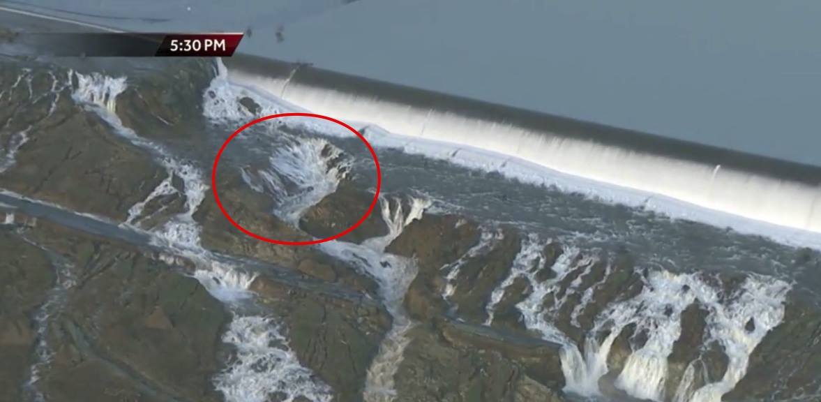
What interests me is that the emergency spillway has large blocks half way down it that (if I remember my theory correctly) are intended to disperse the energy of any water going down it, the idea being to try and prevent high energy water from scouring away the footings of the spillway lower down. Unfortunately what seems to be happening here is that the amount of water is so large the interruption to the flow is firing the excess at an easily erodible hillside.
In the UK those openings in the dam base are known as scour valves, and they are intended to remove accumulations of sediment that inevitably deposit in reservoirs as well as provide an emergency release of water. There are records of such valves opening only to have large plugs of silt emerge like toothpaste from a tube, so there's no guarantee that they would work as a means of reducing water levels and may cause additional problems with the release of large amounts of silty material into the river below.
I can guarantee this will be a case study in Universities for a variety of academic disciplines for some time
Lake level has gone down 0.30, 0.32, 0.36, then 0.23 feet. in the last four hours. That's with a net outflow of at least 60K cfs.
http://www.sacbee.com/news/state/california/water-and-drought/article132332499.html
https://www.wunderground.com/cgi-bin/findweather/getForecast?query=Berry+Creek,+CA

http://www.sacbee.com/news/state/california/water-and-drought/article132332499.html
If they run 24/7 then that could be done in around 4 days. The next storms arrive in two, and look pretty wet.External Quote:Speaking at a 10 p.m. press conference, officials said water had stopped flowing over the emergency spillway and that the release of 100,000 cubic feet of water per second from the main spillway had helped drop the lake level.
"The goal is to get it to drop 50 feet," said Kevin Lawson, a Cal Fire chief. "If we can continue to do that that's great, that brings a little bit of calm to what we are trying to accomplish here."
https://www.wunderground.com/cgi-bin/findweather/getForecast?query=Berry+Creek,+CA
What interests me is that the emergency spillway has large blocks half way down it that (if I remember my theory correctly) are intended to disperse the energy of any water going down it, the idea being to try and prevent high energy water from scouring away the footings of the spillway lower down. Unfortunately what seems to be happening here is that the amount of water is so large the interruption to the flow is firing the excess at an easily erodible hillside.
There's no large blocks halfway down the emergency spillway, just the hillside.
The regular spillway was a straight shot down smooth concrete, the large block there is not intentional.
Z.W. Wolf
Senior Member.
I'm completely naïve on this matter, but it seems this is metavolcanic rock we're talking about - specifically "greenschist-facies metavolcanic rocks of Jurassic age." It's a metamorphic rock, not an igneous rock like granite. How hard is this rock? How permeable?
Is all that material we are seeing at the base of the spillway soil overburden or has that already eroded away? Or are we seeing bare but jagged bedrock? Rock that is permeable and... crumbly is the only word I can naively use. Is this bedrock eroding away? Is there water coming under the spillway through this bedrock?
1:24
External Quote:There may be water seeping under; and I think that's going to be the big fear. Because if that's the case... it would be just like a levee, and you'd see the erosion underneath the auxiliary spillway...
Last edited:
Manuel Haas
New Member
Mick, what do you think about the in flow decreasing so drastically since the lake's level fell under emergency spillway trigger level. Could there be an unaccounted outflow still ongoing causing these miscalculations?
See post: https://www.metabunk.org/oroville-dam-spillway-failure.t8381/page-5#post-199949
And where could they come from. I saw lots of water spilling over the rock left of the emergency spillway.
The media is continues to use the last sense making 37.441 cfs from 8pm in combination with current lake levels and measured outflows.
Edit: Never mind, the newest data shows accurate inflow of 33k cfs.
Is all that material we are seeing at the base of the spillway soil overburden or has that already eroded away? Or are we seeing bare but jagged bedrock?
This rock:
later:
Seems pretty solid.
Mick, what do you think about the in flow decreasing so drastically since the lake's level fell under emergency spillway trigger level. Could there be an unaccounted outflow still ongoing causing these miscalculations?
See post: https://www.metabunk.org/oroville-dam-spillway-failure.t8381/page-5#post-199949
And where could they come from. I saw lots of water spilling over the rock left of the emergency spillway.
The media is continues to use the last sense making 37.441 cfs from 8pm in combination with current lake levels and measured outflows.
It's back at 33K cfs:
http://cdec.water.ca.gov/cgi-progs/queryF?s=ORO
So it was a measurement system glitch. 33K is in line:
Scott Gates
Active Member
The weir must be getting undercut? It looks like much more water is going over the top than earlier this AM, but the actual water level is lower now?
The max outflow over the emergency weir was reportedly ~12,400 cfs Sunday am appx 1:AM PST. Officials reported by mid-day that rate was an estimated 8,000 cfs. Officials notice an area below and close to the weir with erosion occurring and initially believed that erosion was occurring significantly faster than it turned out to be.
In a case like that don't think there is any choice but extreme caution ...
The erosion turned out to be much slower than expected ... but officials went ahead with increasing the outflow thru the main spillway from ~55,000 cfs to 100,000 cfs. Reservoir levels were already dropping and this accelerated that rate.
The increased outflow brought the level down to 901.02 at appx 20:00 PST (10pm Cal time) - which is the emergency weir top ... and flow over the weir stopped, also stopping any erosion.
Last edited:
Scott Gates
Active Member
My PhD (long long ago in a galaxy far far away) is in reservoir sedimentation, so this is very interesting stuff for me.
What interests me is that the emergency spillway has large blocks half way down it that (if I remember my theory correctly) are intended to disperse the energy of any water going down it, the idea being to try and prevent high energy water from scouring away the footings of the spillway lower down. Unfortunately what seems to be happening here is that the amount of water is so large the interruption to the flow is firing the excess at an easily erodible hillside.
In the UK those openings in the dam base are known as scour valves, and they are intended to remove accumulations of sediment that inevitably deposit in reservoirs as well as provide an emergency release of water. There are records of such valves opening only to have large plugs of silt emerge like toothpaste from a tube, so there's no guarantee that they would work as a means of reducing water levels and may cause additional problems with the release of large amounts of silty material into the river below.
I can guarantee this will be a case study in Universities for a variety of academic disciplines for some time
I suspect what you are referring to are the poured concrete "blocks" you can see at ground level along much of the face of the weir wall. The splash point for water laminar flowing down the face of the weir. Makes sense to have a hard surface to handle the water and disperse down the hillside. The erosion area appears to be just downslope very near these "blocks" and the wall ...
And as can be seen in the pic in post #208 all of those blocks are in place, and working ...
Last edited:
Z.W. Wolf
Senior Member.
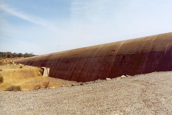
For what it's worth here's what it looked like when the lake was lower. It just looks like a retaining wall.
Perhaps it was never meant to stand up to being topped for days on end and the original designers knew it would blow out. Perhaps it's better just to think of the whole area as the emergency spillway. Just a sacrifice zone to protect the dam proper in the last extreme.
Perhaps it was never meant to stand up to being topped for days on end and the original designers knew it would blow out. Perhaps it's better just to think of the whole area as the emergency spillway. Just a sacrifice zone to protect the dam proper in the last extreme.
Last edited:
RedNeckGeek
New Member
5:30AM PST and evacuation orders are still in place for low lying areas along the Feather River below the Oroville Dam. There are no reports of flooding, and looking out my back door at Lake Oroville, water is down a couple of feet from where it was when the sun went down last night, consistent with the CDEC readings of 898.19'.
Trailspotter
Senior Member.
It's become international news:
Oroville Dam risk: Thousands ordered to evacuate homes
http://www.bbc.co.uk/news/world-us-canada-38952847
Oroville Dam risk: Thousands ordered to evacuate homes
http://www.bbc.co.uk/news/world-us-canada-38952847
- Status
- Not open for further replies.
Similar threads
- Replies
- 19
- Views
- 6K
- Replies
- 3
- Views
- 7K
- Replies
- 42
- Views
- 7K