• MH370 speculation has become excessive recently. Metabunk is not a forum for creating theories by speculation. It's a forum for examining claims, and seeing if they hold up. Please respect this and keep threads on-topic. There are many other forums where speculation is welcome.

MH370: How the AAIB and Inmarsat determined the southern trajectory

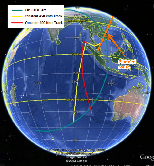
If by "corridors" you mean the blue arcs labeled 00:11UTC:
MH370_How_the_AAIB_and_Inmarsat_determined_the_southern_trajectory__Metabunk_20140325_143647.jpg


Those are not "corridors" in the sense of corridors along which the plane is thought to have travelled. They are a range of possible positions that the plane might be at 00:11UTC. The "ping" would have come from somewhere on the circle that includes those arcs, and the size of the arcs just represents the low and high estimates of the distance the plane travelled.

In some diagrams the middle of the arc is omitted. Here the arcs are joined - it's technically possible that the plane might have flown in circles for a few hours, then headed due east. But other factors seem to eliminate this, which is why the diagram is sometimes shown with a separate north and south arc.

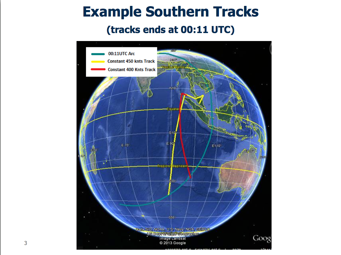
See the yellow and red paths are actual possible paths, each of which end up somewhere on the southern arc.
 
or each handshake, Inmarsat must have recorded the time it took the signal to be sent and received, via the satellite, to the ground station. Then, the distance from the satellite is known. Which allows us to draw those arcs.

That is how I understand the concept.

Keeping in mind that the inmarsat satellite is in geosynchronous orbit. I realize this is counter-intuitive, but again...knowing a bit about orbital mechanics helps to dispel some misconceptions. This is a video that I have found to be very instructive:


(NOTE that the recent, and very popular movie "Gravity", which starred Sandra Bullock and George Clooney did employ some very good physics to display the zero-G environment of LEO (Low Earth Orbit), there were also some "nerdy" mistakes. This video, above, helps to be a bit more scientific).

As a side-bar...Apollo 11 Astronaut "Buzz" Aldrin was known, almost "infamously" (some would say) for his passion about "Orbital Mechanics", and especially orbital rendezvous dynamics.

I highly recommend seeking out some of his writings and thoughts on this topic.
 
Last edited:
If by "corridors" you mean the blue arcs labeled 00:11UTC:
MH370_How_the_AAIB_and_Inmarsat_determined_the_southern_trajectory__Metabunk_20140325_143647.jpg


Those are not "corridors" in the sense of corridors along which the plane is thought to have travelled. They are a range of possible positions that the plane might be at 00:11UTC. The "ping" would have come from somewhere on the circle that includes those arcs.

Yes, that's clear. My question was about the previous pings. Inmarsat must have data about all those pings, starting at takeoff, all the way to the 00:11UTC ping, and even to the "partial ping" later. For each ping, a circle of possible positions can be drawn.

Somebody, with the raw data, could draw those ping circles. By looking at two consecutive ping circles we can say with some certainty whether the plane moved closer to the satellite or away from it (very much like the doppler effect analysis).

Now, each ping circle must intersect with the possible path of the plane (the red line or the yellow line). Therefore we could be able to accept one path and discard the other.
 
This update from the Malaysian Ministry of Transport gives a good overview of how the (very) rough location of MH370 final position was determined.

https://www.facebook.com/permalink.php?story_fbid=740971779281171&id=178566888854999&stream_ref=10

External Quote:

NFORMATION PROVIDED TO MH370 INVESTIGATION BY UK AIR ACCIDENTS INVESTIGATION BRANCH (AAIB)

25/03/14

Refined analysis from Inmarsat (abridged quote)

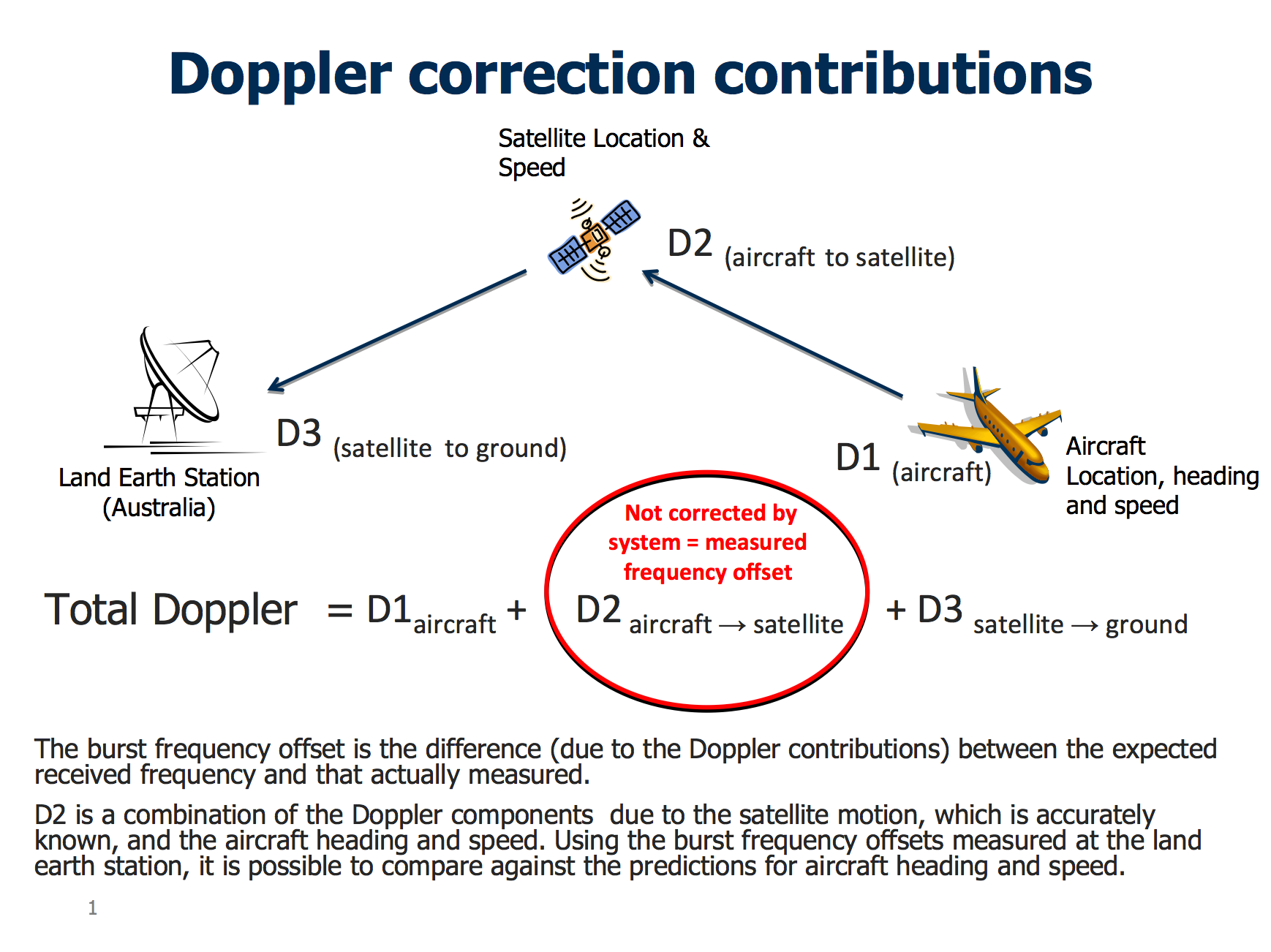
In recent days Inmarsat developed a second innovative technique which considers the velocity of the aircraft relative to the satellite. Depending on this relative movement, the frequency received and transmitted will differ from its normal value, in much the same way that the sound of a passing car changes as it approaches and passes by. This is called the Doppler effect. The Inmarsat technique analyses the difference between the frequency that the ground station expects to receive and that actually measured. This difference is the result of the Doppler effect and is known as the Burst Frequency Offset.

The Burst Frequency Offset changes depending on the location of the aircraft on an arc of possible positions, its direction of travel, and its speed. In order to establish confidence in its theory, Inmarsat checked its predictions using information obtained from six other B777 aircraft flying on the same day in various directions. There was good agreement.

While on the ground at Kuala Lumpur airport, and during the early stage of the flight, MH370 transmitted several messages. At this stage the location of the aircraft and the satellite were known, so it was possible to calculate system characteristics for the aircraft, satellite, and ground station.

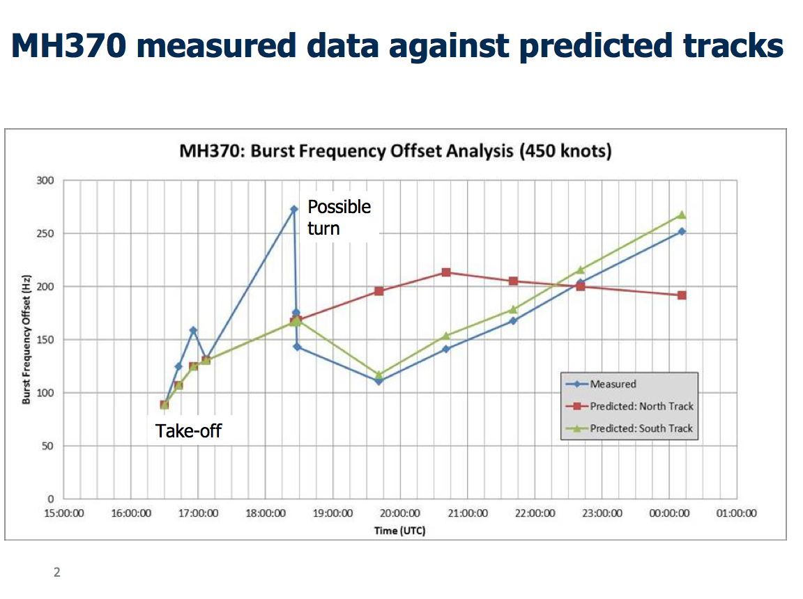
During the flight the ground station logged the transmitted and received pulse frequencies at each handshake. Knowing the system characteristics and position of the satellite it was possible, considering aircraft performance, to determine where on each arc the calculated burst frequency offset fit best.

The analysis showed poor correlation with the Northern corridor, but good correlation with the Southern corridor, and depending on the ground speed of the aircraft it was then possible to estimate positions at 0011 UTC, at which the last complete handshake took place. I must emphasise that this is not the final position of the aircraft....

This analysis by Inmarsat forms the basis for further study to attempt to determine the final position of the aircraft. Accordingly, the Malaysian investigation has set up an international working group, comprising agencies with expertise in satellite communications and aircraft performance, to take this work forward.

3bae79209adafa9ed87f95e45fc4e206.png


MH370 measured data against predicted tracks...


619fb65e39e85503a44d81df149556e9.png

External Quote:

Example southern tracks

This shows the southern tracks for a ground speed of 400 and 450 knots ground speed. It should be noted that further work is required to determine the aircraft speed and final position.
713758d30e7fcd484c0352948875a3fe.png
[/ex]

79ed849c253c74dc00b0af73ce6b9e67.jpg


[/quote]
Dear Mick,

I do not find the data consistent with the known track of 9M-MRO up until 17:27 UTC.

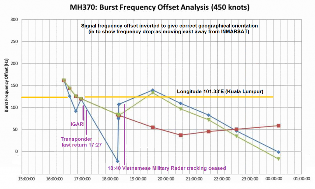
The Burst Offset Frequency ("BOF") analysis chart released by Malaysian Authorities on 24 March is misleading as usual. Perhaps they could have made it more obvious by waiting until April Fool's day to release it?

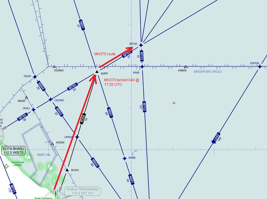
For example we know MH370 was still flying northeast after passing IGARI, because radar transponders continued to track it as it turned from 025 degrees to 040 degrees at 471 kts, heading for waypoint BITOD. Yet the BOF chart shows the signal frequency increasing as it flew away from the INMARSAT satellite at 17:08 UTC.

Whilst the BOF chart suggests MH370 was flying west at 17:08 we know that is untrue from Radar data.

This means the BOF signal was inverted, either by signal processing, or that the data has been inverted by the AAIB or Malaysian Authorities manipulating the facts.

The correct way to read the flight path is upside down. Where it peaks at 18:25 UTC on the original Malaysian released BOF chart, the signal should not be a peak but rather a trough. As a trough it would correctly infer that the aircraft flew northeast which we know to be true from the last transponder signal at 17:27 UTC.

Whilst the scale is wrong it is only by inverting the BOF ping returns that you can properly match satellite returns to the known flight path:

5ba85ec8ef799924ed0f51bcce53ef40.png


this would then create a far more logical explanation for the flight, thus:[/ex]
 
Last edited by a moderator:
they have determined the trajectory based on huge assumptions and BFO&BTO values having huge margin of error(only 1 Hz equates to ~100 km), in reality you can probably make the trajectory to fit these values for more or less any point on the arc

example(the post from duncansteel.com) :

Byan C.
2014/07/03 at 08:22

I woke up wondering if Duncan thinks I'm some kind of crackpot, so I thought I should send you a clearer explanation. If R represents satellite to plane distance, s, p, r reresents the satellite, plane, and reference satellite respectively. Numbers 1 and 2 represents two points in time and x, y, z are the coordinates. Then,
(x-xs)^2 + (y-ys)^2 + (z-zs)^2 = Rs^2
(x-xr)^2 + (y-yr)^2 + (z-zr)^2 = Rr^2
x^2 + y^2 + z^2 = r^2 where r = earth radius and recognizing that
xs^2 + ys^2 + zs^2 = (r+H)^2 where H is the satellite height above the earth. The same applies to the reference satellite.
Converting BTO data to velocities yield:
V-Vsp-Vps = Vpr
Assuming a constant satellite velocity the Vsp + Vps = Rs2 – Rs1
Similarly, Vpr = Rr2-Rr1 or Rr2 = Rr1 + Vpr
This is where I got into trouble. Since Rr2 depends on Rr1 if I don't check the methodology using the course defined by the BTO data, I don't get a good fit to the BTO data at 19:40. After solving, I plug the plane velocities derived from (x2-x1)/(t2-t1) to a program the solves based on the distance traveled between 2 ping rings. This routine calculate the BTO values based on the actual Vsp at time t. Comparisions indicate that my solution using average Vsp values is yielding reasonable results. To calculate values using the actual Vsp value at time t involves solving 10 equations with 10 unknowns. The good news is that the solution would reduce to a quadratic equation. It is interesting that the solution for the equations based on distance traveled yields 2 roots with different latitudes. The solution to the equations based on velocities yields 2 roots with different longitudes. 1 to the west of the satellite and 1 to the east, effectively resulting in 1 solution. As a check, I plugged in Ra and Rs values for the northern and southern paths, it duplicates those paths.

Imagine my shock after I got this debugged (I keep reversing signs in my vector math) and I get a result that indicates the plane took a large circular path to the south heading eventually back to KLIA. I almost fell off my chair. I was not expecting this. I have to admit that I have not been that excited about anything in a long time, hence my need to hurriedly share this with someone.

I'm sharing this at this time because I believe the actual solution will be difficult to achieve. I could sove the 10 equations, but developing reasonable flight paths is beyond my ability.

I indicated that I thought we should keep this private because if there is a 3rd flight path, this will cause hugh controversy and we need to be certain before presenting such a result. Perhaps, my results are just a fluke of the data, but since I achieved these results with absolutely no manipulation of the raw data, I feel like it needs to be pursued further.
Cheers,
Bryan
Would you mind elaborating on exactly what flight path your calculations show compared to the currently accepted path? Starting from the time when primary radar tracking was lost.
 
the flight path is same all the way to the penultimate ping (except my take is that there was a bit wider hook around northern tip of Indonesia(so to skim their airspace), tough chance they could get a 777 across their mainland undetected and they didn't have any reason to do so anyway), the difference is that from the penultimate to ultimate ping the plane could go SE or NE with the same BFO&BTO values (or within margin of error), Bryan has showed the calculation that fits NE path and "accepted" path is calculated for SE
 
I'm not qualified to challenge the math, but I too would like to see how this translates into flight path.

I also remain puzzled why only Inmarsat data has been quoted - there must also have been other satellites within hand-shake reach of the missing flight. Or is the consideration off-limits?
 
Is anybody else growing increasingly suspicious of the Inmarsat data?

For one, The ping time (which gives the line-of-sight distance) includes the response time of the electronics in the aircraft. Every 1 ms of response/reaction/activation time corresponds to 300 km line-of-sight deviation, or roughly 500 km towards West along the surface of the earth, considering the geometries involved in this case. Was the response time of the electronics (a) known, and (b) included in your calculations for those very theoretical thin-line arcs, which were presented as if there would have been no tolerances?

Secondly, the Doppler that is considered is based on very small frequency shifts between pings with one hour intervals, not observations of a continuous signal, according to what has been publicized. The oscillator for this type of health check apparatus (in the plane) has no need to be especially frequency stable, since in normal use that would have no significance.
Therefore, the oscillator may have easily drifted between the hourly pings, due for example to temperature changes (if the plane changed altitude, which we do not know), or if the on-board power supply voltage changed due to other reasons. Therefore it is a rather inexact and daring assumption to ascribe the hourly frequency differences to a "Doppler effect due to the plane's movement". That is a big leap of faith.

Lastly, something that has not really been brought up and is something I've always been curious about. Why was there only 1 company in the entire world that had this sort of data? Surely there are dozens and dozens of similar types of companies around the world that would have tracked similar type of data. I find it very difficult to believe there was just 1.

This is not a conspiracy theory. Debunking is about critically analyzing lines of evidence. In this case, there truly is no evidence. There is no raw data that has been released. Inmarsat released data which they have compiled based on the raw data. I know some would say that the actual raw data would be lines of code that are unreadable, but still, why the lack of transparency? And in addition, there is absolutely zero corroborating evidence. I don't think it's so crazy for a man of science to have a tough time accepting the data and its implications.
 
However, to be fair, I would still bet my money that Inmarsat is right, only because it just seems to farfetched for them to publish fake data. I am, however, nowhere close to convinced as I'd like to be.
 
you are right, BFO&BTO values are highly unreliable but they could give a hint or two if you perform some math (and forget their reliability factor)

"Why was there only 1 company in the entire world that had this sort of data?"

Because only they were paid to communicate with the plane.
 
Back
Top