
You are using an out of date browser. It may not display this or other websites correctly.
You should upgrade or use an alternative browser.
You should upgrade or use an alternative browser.
MH17: Video of flight activity before and after the crash
- Thread starter Mick West
- Start date
MH 17 was ordered to change the Flight direct to Rostov RND and the to TIKNA because aif Trafiic
Can you provide a reference for this order, and quote exactly what it was?
WeedWhacker
Senior Member
It's commonplace when a flight (say MH17) requests an altitude change (for example) that Air Traffic Control will attempt to accommodate that request by re-routing the requesting flight (to avoid traffic conflicts with other flights)....in order to help out. Some Controllers will simply say "No" (well, "unable" actually....or something similar). Some Controllers will go out of their way to assist a request.
It is on the Report of DSB 2.5.4 and in the coversation
http://www.onderzoeksraad.nl/en/ond...sh-mh17-17-july-2014/preliminary-report#fasen
When i could see right, the two planes were on FL350 and FL370
http://www.onderzoeksraad.nl/en/ond...sh-mh17-17-july-2014/preliminary-report#fasen
When i could see right, the two planes were on FL350 and FL370
Last edited:
WeedWhacker
Senior Member
In the image accompanying your post #5 (above) there is text beneath that states:
An ATC clearance is usually at the request of the flight...OR is a procedural thing, because...it is at a certain point in a flight.
It is not an "order". (Perhaps the use of the term "ordered" in post #2 might lead to confusion about how Air Traffic Control actually operates, and its co-ordination with flights in the air (and on the ground) over-all?).
Air Traffic Control can impose an "order" (in a sense) on a flight IF it is necessary to provide adequate separation standards, or (for instance) other things, such as a Holding Pattern for traffic control purposes.
So....yes, ATC can "order" (better term is "impose") restrictions and directions. This, besides the examples above, can include speed and altitude restrictions at certain geographical points as well.
Sorry it's so complicated....difficult to express in simple words.
There is a movie titled "Pushing Tin" that came out in 1999. Overly dramatic, but a good insight for non-pilots.
(EDIT): The movie mentioned above is more about the frantic and highly-paced function of an Air Traffic Controller in the 'local' environment...where the airplanes are MUCH closer together than in the High Altitude sectors of airspace.
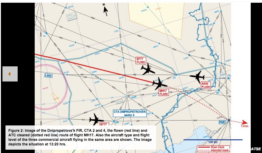
I highlighted the phrase "ATC cleared" for emphasis.Figure 2: Image of the Dnipropetrovs'k FIR, CTA 2 and 4, the flown (red line) and ATC cleared (dotted red line) route of flight MH17. Also the aircraft type and flight level of the three commercial aircraft flying in the same area are shown. The image depicts the situation at 13:20 hrs.
An ATC clearance is usually at the request of the flight...OR is a procedural thing, because...it is at a certain point in a flight.
It is not an "order". (Perhaps the use of the term "ordered" in post #2 might lead to confusion about how Air Traffic Control actually operates, and its co-ordination with flights in the air (and on the ground) over-all?).
Air Traffic Control can impose an "order" (in a sense) on a flight IF it is necessary to provide adequate separation standards, or (for instance) other things, such as a Holding Pattern for traffic control purposes.
So....yes, ATC can "order" (better term is "impose") restrictions and directions. This, besides the examples above, can include speed and altitude restrictions at certain geographical points as well.
Sorry it's so complicated....difficult to express in simple words.
There is a movie titled "Pushing Tin" that came out in 1999. Overly dramatic, but a good insight for non-pilots.
(EDIT): The movie mentioned above is more about the frantic and highly-paced function of an Air Traffic Controller in the 'local' environment...where the airplanes are MUCH closer together than in the High Altitude sectors of airspace.
Sorry for double Post. I see no reason why there was a Conflict with Traffic at the Point NE of Rostov.
So the new Route goes direct over the possible Buk starting Place and nearby the Military Radar contact on Russian Border. I don´t know if the Rostov NOTAMN was already postet, it was published at 16.July and the Area araound TAMAK was also closed under FL320 because of Shooting from UA to RU. So if UA normaly have to close completly the Area Russia have also close the Area. That also the Point i don´t understand why ATC Rostov want to change the Route direct over the Area.
NOTAMN
(V6158/14 NOTAMNQ)URRV/QARLC/IV/NBO/E/000/530/4818N04008E088A)URRV B)1407170000 C)1408312359 ESTE)DUE TO COMBAT ACTIONS ON THE TERRITORY OF THE UKRAINE NEAR THESTATE BORDER WITH THE RUSSIAN FEDERATION AND THE FACTS OF FIRINGFROM THE TERRITORY OF THE UKRAINE TOWARDS THE TERRITORY OF RUSSIANFEDERATION, TO ENSURE INTL FLT SAFETY,ATS RTE SEGMENTS CLSD AS FLW:A100 *MIMRA - ROSTOV-NA-DONU VOR/DME (RND),B145 *KANON - ASMIL,G247 *MIMRA - BAGAYEVSKIY NDB (BA),A87 * TAMAK - SARNA,A102 *PENEG - NALEM,A225 *GUKOL - ODETA,A712 *TAMAK - SAMBEK NDB (SB),B493 *FASAD - ROSTOV-NA-DONU VOR/DME (RND),B947 *TAMAK - ROSTOV-NA-DONU VOR/DME (RND),G118 *LATRI - BAGAYEVSKIY NDB (BA),G534 *MIMRA - TOROS,G904 *FASAD - SUTAG,R114 *BAGAYEVSKIY NDB (BA)-NALEM.* *SFC - FL320.DEP FM/ARR TO ROSTOV-NA-DONU AD TO/FM MOSCOW FIR CARRIED OUT ALONGATS RTE G128 KONSTANTINOVSK NDB (KA) - MOROZOVSK VOR/DME (MOR) ANDR11 MOROZOVSK VOR/DME (MOR) - BUTRI ON ASSIGNED FL.DEP FM ROSTOV-NA-DONU AD TO DNEPROPETROVSK FIR CARRIED OUT ALONGATS RTE A102 KONSTANTINOVSK NDB (KA) - NALEM ON FL340 AND ABOVE.ARR TO ROSTOV-NA-DONU AD FM DNEPROPETROVSK FIR CARRIED OUT ALONGATS RTE A712 TAMAK - SAMBEK NDB (SB) THEN DCT KONSTANTINOVSK NDB(KA) ON FL330 AND ABOVE.SFC TO FL530.)
WeedWhacker
Senior Member
I see no reason why there was a Conflict with Traffic at the Point NE of Rostov.
I could be mistaken, but somewhere I had seen that the crew of MH17 had requested an altitude change.
(This is VERY common when the aircraft has consumed fuel, which of course has weight...and it is MORE efficient when the airplane is at a lighter over-all weight, to climb to a higher cruise altitude...and thus conserve fuel, by using less).
In order to accommodate that requested altitude change, the one requesting the change might be re-routed, to avoid conflicts with other flights already at altitudes that conflict WITH the change...(i.e., the climb UP).
The ATC routing to RND was just seconds before the plane was lost, so it seems unlikely to have had any effect on the outcome. Notice that the actual track of the plane shows no actual deviation towards RND, so they likely never even made the turn.
Here's the ATC discussion.
Now obviously in hindsight it was a bad decision to be flying anywhere near he area, but as the video shows, it was perfectly normal for traffic to fly over that region. MH17 was just unlucky.
Last edited:
WeedWhacker
Senior Member
Here's the ATC discussion.
This may be unfamiliar to some.
It's important to heed the 'headings' shown at the top of the transcript, and know that an Air Traffic Controller is being recorded BOTH as he/she communicates on the radio, and also as he/she communicates with OTHER Air Traffic Controllers, via telephone.
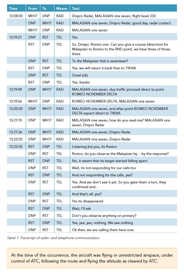
NOTE also please at 13:20:00 ATC says:
"MALASIAN one seven, and after ROMEO NOVEMBER DELTA expect direct to TIKNA"
Again, I highlighted in red the word "expect". This is not an ATC 'clearance'...it is an advisement....an "anticipation" to expect a clearance later.
Radio protocol procedures require this, when a flight has been taken away from its filed Flight Plan. SO? If all radio communication is somehow lost subsequently, both ATC and the flight crew know how to proceed.
Last edited:
WeedWhacker
Senior Member
I also need to add that merely based on the image of the flights shown in the attachment in post #9.....oh wait, I see the alteration to that post.
What I am trying to say is that ATC looks at a VERY big picture, and tries to anticipate to the best of their ability, minute-by-minute.
Not knowing the actual weather at cruise altitude that may (or may not?) have also been a factor....this is an added complication (for ATC personnel). Flight crews see weather, on the radar, that they want to avoid....by deviating OFF their planned routings. They must request from ATC....OR exercise "Emergency Authority" in extreme cases....which involves a LOT of paperwork and discussion, afterwards. (Falls upon the Captain).
I hope people can grasp how complicated that becomes, and how much of this can also fall upon the 'shoulders' of those ATC professionals when presented with a crisis.
Yes Mark, it is make no differenz because the change never happend. i only want to know why Rostov wants the change at that Time Point. The Controll of MH 17 was at UA Border via DNP. Rostov calls DNP on Phone that MH 17 change the Route. I think that is normaly and very often done before in normal Flights.
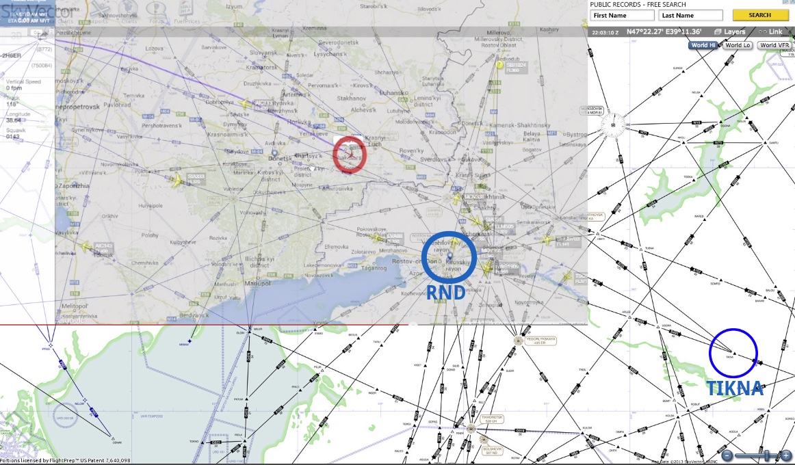
It is very conspiary, and i don´t really beleave myself, but is it possible the the downing was planed from Russia. They send the MH over the BUK place and the Place were the Military Flight Contact was seen on MoD Video. In the middle a new Radar Contact at 13.20.39 (Time Stamp right Box) an new Radar Contct is seen (at Russian Border left of TAMAK).
At this Place GE shows a Helicopter Landing Place. 47°48'46.27"N 38°51'24.41"E. Also a lot of Militay Object is seen at the Area. So it may be..... the RU send MH17 over BUK Place AND right to Helicopter. But the BUK pushed the "red button" to early so that MH17 does not shoot at UA Area and went down at RU Border.
Once more: it is really conspirally but i want to talk to you about.
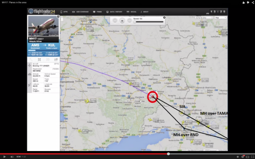
TIKNA is way off to the right of this video. So the video would probably not show any conflicting traffic.Edit: from the ATC briefing it sounds like the deviation was for traffic heading to ROV (Rostov).
Actually, having looked at the charts, RND is Rostov. So originally they were flying direct to TIKNA, but were re-routed to RND (Rostov). So my original point is still valid, the traffic would have been heading for TIKNA (or other points to the East side of the video), and so quite likely would have been off screen in the video. Either way, it's a minor (and typical) course change that did not happen.
WeedWhacker
Senior Member
Either way, it's a minor (and typical) course change that did not happen.
Point.
Made.
The usual and common routine airline flight is.....usual and common. It is routine and usually not fraught with "drama" because it is procedurally "regimented" in a standardized way.
WeedWhacker
Senior Member
I need to add (in order to "augment" the discussion) that EVERY aviation reference that is only three letters? Is a VOR or a VORTAC ('VORTAC's for high altitude usage).
EVERY aviation navigational reference that has FIVE letters? Is an "intersection" (years ago) but now with GPS technology....a "Way Point".
(An "Intersection" is where two, or more flight routes cross...just as an "intersection" on a road that a car might drive....just more complicated).
Instrument Landing Systems ('ILS') and even just a simple Localizer (without a Glide-Slope) use a FOUR-digit identifier.....which ALWAYS begins with the letter "I".
Gets MORE complicated when discussing AIRPORTS!! Everyone certainly knows the three-digit codes....these are codes.
For aviation professionals, EVERY airport has a four-digit [url=http://en.wikipedia.org/wiki/International_Civil_Aviation_Organization_airport_code]ICAO code.
(You can see why it's difficult to explain, unless you are in the profession).[/url]
If i am right, commander can request alighnment even he wants to reduce time of flight or for fuel economy. And ATC can permit the request If there is no any danger for other flights.MH 17 was ordered to change the Flight direct to Rostov RND and the to TIKNA because of Trafiic (we have three of them). But i can´t really see that it was a conflict with other planes at the Point.
Can anyone help?
WeedWhacker
Senior Member
If i am right, commander can request alighnment even he wants to reduce time of flight or for fuel economy. And ATC can permit the request If there is no any danger for other flights.
If I may? The Pilot in Command (or, "PIC") may take ANY steps he/she deems necessary to protect the airplane. EVEN if it means exceeding an ATC restriction. (....perhaps some pilots do not know this??).
However, in the case of "MH17"....it was (to the flight crew) perfectly routine.
HOWEVER!...MH 17 and the other MH fight? MH17 was typically normal, and was SHOT DOWN by mistake.
MH5810? Another 'story'.....(I have ideas about it, based on some recent info).
You mean MH370, or QZ8501?MH5810? Another 'story'.
WeedWhacker
Senior Member
You mean MH370, or QZ8501?
Yes, sorry. QZ8501.
A different airline company, but in a similar region of the World.
Adding? (and this is preliminary) I heard on the radio that one report, from the DFDR (Digital Flight Data Recorder) recovered from the wreckage of QZ8501 showed an ascent rate of (at least) 6.000 feet per minute...UP. Now, any pilot here will know that such a 'fpm' rate AT that altitude can only be achieved by (A) "Swapping airspeed for altitude"....(which is a zero-sum game, ultimately) or (B)....atmospheric encounters.
The Earth's atmosphere is FAR more powerful than many realize. "IF" (and this is me, summarizing) this crew DID NOT exercise (well, the Captain, that is) did not exercise "Emergency Authority" to deviate off-course. Instead....flew right into a powerful thunderstorm....this would explain the +6000 feet per minute vertical aspect.
Upset.....possible crew disorientation....ETC.....
1. Of course, any danger to the paxes or the crew team can be the reason for an alignment request to ATC. And if i am right, PIC must prove (i dunno exactly) such kind of the extreme reason (and submit actual aboard conditions) and demand current ATC for approval.If I may?
1.The Pilot in Command (or, "PIC") may take ANY steps he/she deems necessary to protect the airplane. EVEN if it means exceeding an ATC restriction. (....perhaps some pilots do not know this??).
2. However, in the case of "MH17"....it was (to the flight crew) perfectly routine.
3. HOWEVER!...MH 17 and the other MH fight? MH17 was typically normal, and was SHOT DOWN by mistake.
4. MH5810? Another 'story'.....(I have ideas about it, based on some recent info).
2. Who knows the end? Sorry for all the victims.
3. I want to consider it was one of most terrible mistake in human history. And better fatal accident.
4. Boing remote covering malfunctions to obtain insurance? (It is IMHO. Pls, point us to needed conspiracy topic).
Is it possible to get the same FR24 Vid for 24.July?
http://www.whathappenedtoflightmh17...rspace-best-evidence-for-russian-involvement/
http://www.whathappenedtoflightmh17...rspace-best-evidence-for-russian-involvement/
Is it possible to get the same FR24 Vid for 24.July?
http://www.whathappenedtoflightmh17...rspace-best-evidence-for-russian-involvement/
No, FR24 only goes back 2 months with Premium.
So it is impossible to proof.
Prove what?
Did you actually see EL122 on the map departing Rostov, overfly East Ukraine and head towards Tessaloniki? Or did you see EL122 being mentioned in the list? As said,the list has shows some flights which did NOT overfly East Ukraine.
Also some airline names are incorrect. CORRECT!V used the old IATA designator.
The same flight you mentioned for example is shown on the map as All Nippon 121 from Tessaloniki to Rostov. Impossible. The correct airline is Ellinair (flight EL112) from Greece which does operate to Rostov.
No idea why code EL is 'translated' to All Nippon. I am very curious if CORRECT!V used the correct data for GPS positions or made a mistake in mapping.
Pete Tar
Senior Member.
Depends on the level of reasonable doubt you want to apply. You may be able to find discussion from that period of time somewhere on the interent though where someone screencapped flightradar24 information.
But there are records other than flightradar24, you may have to ask the actual airports for those though - so it can be proved if you really need it to be, it just takes a lot more effort.
But there are records other than flightradar24, you may have to ask the actual airports for those though - so it can be proved if you really need it to be, it just takes a lot more effort.
Rob
Member
For the record, Correct!V created a very nice application showing flight activity over Eastern Ukraine on the 17th of July (including MH17) and also for the 24th:
https://apps.correctiv.org/mh17/
First thing is the source of the data. The note at the bottom explains that the data has been obtained "mit freundlicher benehmigung" (with friendly permission/licensing) from flightradar24.
Second thing to note is that this application shows not just the registered civil planes shown in Mick's animation, but also a large number of unidentified private planes.
Seems to me that this (unless disproven) is a valuable resource, which adds more detail to Mick's animation.
And yes, also flightradar24 data of Russian airliners continuing to fly over Eastern Ukraine on the 24th of july.
Last edited:
Similar threads
- Replies
- 16
- Views
- 1K
- Replies
- 60
- Views
- 2K
- Replies
- 7
- Views
- 773