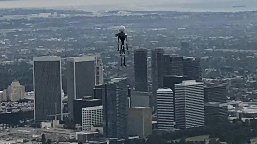
Jellyfish UFO from TMZ's 'UFO Revolution'

If this is a balloon that means NATO cannot protect itself from balloons
This video is reportedly from 2018. Nearly five years later, last year, we had an alleged Chinese spy balloon traverse the entirety of the USA before the govt decided to do anything. To me, it suggests that the defense big-wigs arent overly concerned to sound the alarms, mobilize the troops and start shooting in the air every time a balloon flies overhead. If anything the leak of this footage shows what they do. They record it.

If this is aliens... This website will be completely useless and a few people here has to go back to coding mobile games.
Not sure if you are aware, this website hosts skeptical discussions on many topics other than UAP footage.
Also I know you are not trying to hide your bias, but after disclosure of aliens, I'm going to guess there will be 1000s of times more bunk generated
 
1. If this is a balloon that means NATO cannot protect itself from balloons. Think of this video where a balloon was theoretically able to scan the entire joint op base without harm. Or think of the 3-4 downed ballons from february. It seems like we are a birthday party away from world war 3.

2. If this is aliens... This website will be completely useless and a few people here has to go back to coding mobile games.

3. If this is chinese or russian tech the first point applies.

Pick your poison.
Because there are only three poisons?
 
Let's try to keep this thread to analysis only, otherwise it's going to be a mess.
Avoid humor and sarcasm, as it can easily be misunderstood
Avoid personal attacks or criticism
Keep it polite
Thanks!
 
This is the launch vehicle / tether point for the aerostat - seems like a pretty permanent location - so that gives us its Lat Long. Whats its altitude?

1704903396794.png

1704903480192.png
 
If you look at the pics, my google maps gives me 2024 data, and some buildings are already missing compared to the other 2023 google maps pictures. Seems like part of the personell left the base in the recent months. Might explain why and how the footage was "unclassified". To be frank it was never classified but if the base is not in use anymore, releasing this video after leaving the base would not break natsec.

Also, if this is a tethered aerostat taking the video, the object moved and parallax explanations are out of the picture.
 
This is the launch vehicle / tether point for the aerostat - seems like a pretty permanent location - so that gives us its Lat Long. Whats its altitude?

1704903396794.png

1704903480192.png
Can we work out with shadow length, we'd need time of day/and both maybe we can work it out from another fixed shadow
 
If you look at the pics, my google maps gives me 2024 data, and some buildings are already missing compared to the other 2023 google maps pictures. Seems like part of the personell left the base in the recent months. Might explain why and how the footage was "unclassified". To be frank it was never classified but if the base is not in use anymore, releasing this video after leaving the base would not break natsec.

Also, if this is a tethered aerostat taking the video, the object moved and parallax explanations are out of the picture.
Parallax can come from following/tracking a moving object from a static viewpoint as well.
 
Its a 3.5km slant range, GoogleEarth gives a range to those buildings as 3.436km

1704904057754.png

Simple trig then puts the aerostat at 0.666 km altitude = 2185. ft.
 
Great work!

The altitude might discernable by figuring out what angle the shipping containers are viewed from. Like these:
2024-01-10_08-25-56.jpg
They will be level, so just need to match the angle.

We can also make a ground track, and then Sitrec it
 

One thing to remember when looking at this is that the image is thermal and if these are mylar balloons they'll be reflecting varying heat signatures from their environment toward the camera as the angles change and if the heat signature matches the background closely enough elements would "disappear."
 
Thanks to Flarkey's photo collage
EDIT: AND Dave51c's youtube comments for the 2017 date

iraq_jellyfish_base3.png

Those buildings are not there in images dated 2/21/2018, but they are there 5/22/2017
Corbell gives the Date/Time as "October 2018 (night)"

If Google Earth is correct, then the images are from before 2/21/2018, and not Oct 2018
 
Sorry @flarkey, I don't have your knowledge of these things-
- does "ground height at crosshairs" mean the altitude of whatever the optics system is focussed on?
It means the system calculates the height of the ground where the operator is pointing it - ie at the crosshairs. Different MX systems use different methods for this, a) simple trigonometry or b) looking up a world digital terrain elevation data (DTED). I suspect that US systems use the DTED method).
 
Also, if this is a tethered aerostat taking the video, the object moved and parallax explanations are out of the picture.
Yeah, so we seem to be left with an object drifting along in a very light breeze. Parallax cannot account for the fact that it moves, but can impact the apparent speed at which it is moving, depending on distance to the camera -- if it is close, it crosses the background faster and appears to be moving faster.

Note that the barely moving flag indicates wind speed at that very low altitude where the flag is. Get up above ground clutter, there may well be more wind.
 
Those buildings are not there in images dated 2/21/2018, but they are there 5/22/2017
Corbell gives the Date/Time as "October 2018 (night)"

If Google Earth is correct, then the images are from before 2/21/2018, and not Oct 2018
Not that we should trust a random YouTube comment but @MRCinco96 on YouTube says he believes it was fall 2017 and that he viewed the video around 01/2018. This is seen above from user Dave51c.

Going by Corbell's history I trust random YouTube comment more than him.
 
Last edited:
Those buildings are not there in images dated 2/21/2018, but they are there 5/22/2017
Corbell gives the Date/Time as "October 2018 (night)"

If Google Earth is correct, then the images are from before 2/21/2018, and not Oct 2018


Not trying to beat a dead horse but, Knapp posted to twitter that they've had this video for a few YEARS.
Since they've decided that now is the right time to go public, have they, in the interest of disclosure and transparency, formally posted a report on the details they managed to track down?
Or were they not able to determine the location and the approximate date in that amount of time?

I thought the 29 Palms flares would have made them a little more cautious


Source: https://twitter.com/g_knapp/status/1744816009931018386
 
Last edited:
Capture.JPG
Possibly this has been mentioned and I missed it, but as it passes cars and such a few times, we get SOME information about size. If this has already been mentioned, this can be deleted.

If it is as far away as these trucks, it's somewhere around 5-7 feet tall. That would be consistent with large bunch of party balloons. But of course it may be a lot closer to the camera than the trucks are, and the closer it is to the camera the smaller (and slower) it is.

(It ought to be possible to get maximum possible speed over ground as it passes objects of known size, for the mathy among you.)
 
The first frame compared to the last frame make me think there was no movement
 

Attachments

  • RPReplay_Final1704895648.mov
    6.4 MB
Not that we should trust a random YouTube comment but @MRCinco96 on YouTube says he believes it was fall 2017 and that he viewed the video around 01/2018. This is seem above from user Dave51c.

Going by Corbell's history I trust random YouTube comment more than him.

I am not saying to trust people's opinion as fact but this is not the usual he said she said. This is a NATO-wide natsec matter.

It would be much easier to take Knapp and Corbell down with the usual ad hominims IF they went after money. Yet we can watch the video for free.

It would be much easier to assume Corbell did not perform due dilligence IF this topic was not national security. The guy was sitting at congress in an official hearing about UAPs next to the ex-intel director, Knapp and Karl E. Nell, so I assume he knows what due dilligence is.

When Corbell says the video is from 2018 then there might be a reason for that. Maybe the date is classified too. Maybe he is protecting sources. Maybe he deliberately muddies the water to force a lie out of the pentagon. Who knows.


One thing is certain. Using ad hominims to take a VIDEO down is a good sign that you are out of explanations.
 
Apart from the danger of munitions hitting civilians or friendly troops (US or other), maybe miles away, we don't even know if the observing craft (manned or unmanned) was carrying suitable weapons and ammunition. Offhand I don't recall drones of the Predator kind being equipped for air-to-air action.
Predators carried Hellfires which had an air-to-air capability against low performance targets. I think they could also carry Stinger AAMs.
 
But still, it does not matter if it is a drone or a jetplane, you can't take either out for a stroll. You need to have an order to follow an object, especially over an airbase. The assumption that someone was just flying around and saw a balloon is borderline trolling. This is a joint operations base ffs.

Not at all, drones and other aerial reconnaisance assets very often fly pre-planned trajectories looking around to see what they can find. They reach a target zone and orbit there cheking the situation. This is one example (a manned Boeing E7-A, in this case, orbiting over the Poland eastern border):
1704907565701.png
https://www.itamilradar.com/2024/01/02/new-raaf-surveillance-mission/

It's quite possible (I actually think 'probable') the drone (or what the platform was) was just there orbiting when it happened to spot the 'object', which was then tracked. Once it was decided the object did not present any danger (which is the case if it was a party balloon) it was left to go wherever it pleased. Why waste 3-400K$ to shoot an AIM-9X to a very difficult target (which surely the missile was not designed for, it may not even be able of a successful interception on such a target) plus risking injuries or damages on the ground? That would be, at best, a silly thing to do. There's nothing strange here, and surely no 'borderline trolling' (as per your quote).
 
I'm trying to see something move here, but I honestly can't. It looks a bit weird due to the auto-adjust of the IR image + the sharpening step in the video processing .. err, process and the extra sharpening done by the poster for this specific clip - but I don't see any movement beyond that.

Coming to think of it, the integrated sharpening step could be the culprit that makes an out of focus smudge look like something that's more in focus than it should be.

sharpening.png

*https://www.manualslib.com/manual/1...tml?page=83&term=sharpening&selected=2#manual
 
Last edited:
However if this was taken from a tethered aerostat, then the movement of the balloon cluster is real.

We can probably work out a speed range, which will depend on the distance from the aerostat to the object/balloon cluster, and from the object/balloon cluster to the background landscape. For instance if the object/balloon cluster is half-way between the aerostat and the background landscape, then the actual speed of the object/balloon cluster would be half the apparent speed of the landscape behind.

I'd estimate that the landscape behind seems to be moving at 10-20mph; that makes the speed of the object/balloon cluster to be around half that, with quite a large error bar.
 
Is there any way to get historical wind speed and direction of this location to see if it would push balloons or other floating objects towards lake Habbaniyah?

Edit: NM that wouldn't be useful without a specific day date.
 
Last edited:
Back
Top