zebra100
Member
Attachments
Last edited by a moderator:

I for one applaud the ATSB for considering alternative search areas, "should the arc defined by the handshake be called into question".External Quote:"should the arc defined by the handshake data be called into question, the various timing and acoustic considerations discussed here would suggest that a reasonable place to look for the aircraft would be near where the position line defined by a bearing of 301.6° from HA01 crosses the Chagos-Laccadive Ridge, at approximately 2.3°S, 73.7°E"
Did the increased fuel burn cause the most probable track to move north, as the sentence implies (but does not explicitly state...)? If so, how could it have caused this? Consider Fig.3, p.5:External Quote:On 27 March (D20), the JIT advised they now had more confidence in the increased speeds provided by primary radar near Malaysia. This increased the aircraft fuel burn and the most probable track moved north to the S3 area.

"On 7 March 2014 at 1722 UTC1 (8 March 0022 local time Malaysia), flight MH370, a Boeing 777-
200ER registered 9M-MRO, lost contact with ATC during a transition of airspace between
Malaysia and Vietnam"
The first sentence is already wrong--MH370 lost contact at 00:22 Malaysia local time--that's how they prepared this report-
ATSB's March 27 fuel analysis
It cannot possibly have been the line defining S4/S5 in Fig.4 on p.6, because that line crosses the original (S1/S2/S3) maximum range line - and the one thing on which we can all agree is that the removal of fuel could not possibly have added range.
The report's statement I quoted in #5 above logically implies:I can't find this. Can you provide a copy please?
If your post expressed a desire to see the details showing how the investigation team connected these dots: welcome aboard.External Quote:
The search area for missing Malaysia Airlines flight MH370 has been updated after a new credible lead was provided to the Australian Maritime Safety Authority (AMSA).
As a result today's search will shift to an area 1,100 kilometres to the north east based on updated advice provided by the international investigation team in Malaysia. The Australian Transport Safety Bureau (ATSB), Australia's investigation agency, has examined this advice and determined that this is the most credible lead to where debris may be located.
The new search area is approximately 319,000 square kilometres and around 1,850 kilometres west of Perth.
The new information is based on continuing analysis of radar data between the South China Sea and the Strait of Malacca before radar contact was lost. It indicated that the aircraft was travelling faster than previously estimated, resulting in increased fuel usage and reducing the possible distance the aircraft travelled south into the Indian Ocean.
ATSB advises the potential flight path may be the subject of further refinement as the international investigative team supporting the search continues their analysis.
and determined that this is the most credible lead to where debris may be located.
Based on the surface currents in that map you included TW, wouldn't it have been wiser to do an underwater search starting in S3 perhaps, since the currents in the SIO rotate counter clockwise, and in the corridor where they most likely believe the plane ditched due to inmarsat, the current is actually moving north.I think you are a little confused. The maps you are referencing are located in the "Surface Search" part of the report. At this point in the search it was still an air search and they were searching for surface debris. Debris would have given a pointer to the crash site after taking into account 20 days of drift due to ocean currents.
The following map gives a good idea of the prevailing currents.
https://www.metabunk.org/data/MetaMirrorCache/384bae8d88a379725223866abddcdd5a.png
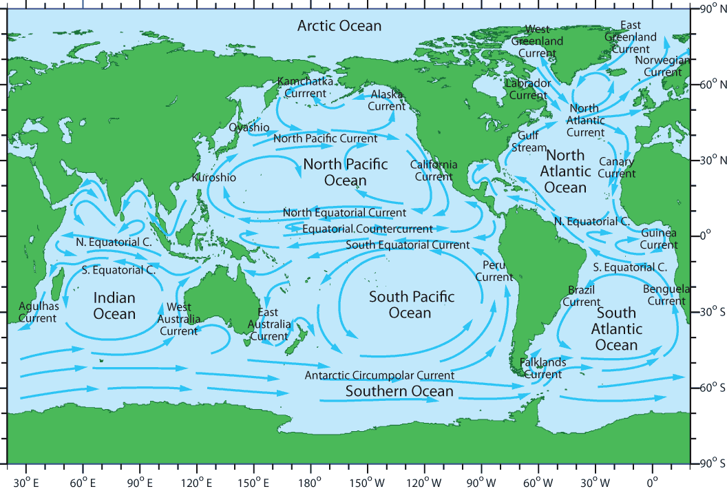
With respect, TWC, it is you who is confused. My argument (#5 above) - including the extracted figure, and all extracted quotes - is based strictly on Figure 3, page 5 of the June 26 report, in the section entitled "possible impact areas".I think you are a little confused. The maps you are referencing are located in the "Surface Search" part of the report. At this point in the search it was still an air search and they were searching for surface debris. Debris would have given a pointer to the crash site after taking into account 20 days of drift due to ocean currents.
But ocean surface currents in that corridor move north, north east, not south or south east.If your argument is correct, the March 28 release should have read: "we did fuel analysis that moved the most probable impact point to the west (per move to black or red max range line in #5, above), but ocean currents March 8->March 28 would have more than offset this, and so that's why we're moving the debris search east. (When we finally start searching for the FDR, we'll be sure to start further west, per the fuel analysis.)"
I think you are a little confused. The maps you are referencing are located in the "Surface Search" part of the report. At this point in the search it was still an air search and they were searching for surface debris. Debris would have given a pointer to the crash site after taking into account 20 days of drift due to ocean currents.
The following map gives a good idea of the prevailing currents.
http://www.seos-project.eu/modules/oceancurrents/images/global_currents.png
External Quote:Janette Lindesay, an associate professor at the Fenner School of Environment and Society, also said the objects could have moved hundreds of miles, and added that while the possible debris would be drifting generally west, it may have been buffeted by other winds and drifted north or south, making the search even more difficult.
"It is an area with a continuing series of low pressure weather systems that are steered by this westerly wind. They [the weather systems] have strong winds associated with them, and the wind direction also changes between south westerly and north westerly, depending on where you are in relation to these cold fronts," she said.
At the risk of wasting time on a quibble: the report's opening sentence should have read, "8 March 0122 local time Malaysia". The opening statement is in fact factually incorrect.That's what it says: (8 March 0022 local time Malaysia)
At the risk of wasting time on a quibble: the report's opening sentence should have read, "8 March 0122 local time Malaysia". The opening statement is in fact factually incorrect.
zebra100 was correct in pointing out the error (which I believe he was paraphrasing in his own comment, as a literary eye-roll - not attempting to correct).
Ah yes, I had mistaken the paraphrasing as a correction.
So does this type of error lend weight to the cover-up theory, or the messed-up theory?
How "big" would the something they are hiding have to be to involve a multinational cover up? You wouldn't need to cover up the fact that they were seeking asylum, or if there were hijackers on the plane. Stories like that surface every year to be honest with you, so what would the hiding something "big" have to be in order for such a large cover up to be needed.But every day's delay in this admission makes me ever more convinced that what they're hiding is big.
Can we at least agree that"Impassioned"? I'm just trying to be realistic. We don't know what the analysis was. You are criticising the end result (simplified for public consumption) without knowing what went into it.
I am not going to offer my speculation on this thread as to what a hypothetical cover-up might specifically be covering up, nor its precise extent/scope. All I will say is that I've seen enough to become suspicious, and that scope, if sufficiently senior, could conceivably be quite narrow (i.e. rank and file working diligently, with best intentions).How "big" would the something they are hiding have to be to involve a multinational cover up? You wouldn't need to cover up the fact that they were seeking asylum, or if there were hijackers on the plane. Stories like that surface every year to be honest with you, so what would the hiding something "big" have to be in order for such a large cover up to be needed.
"Impassioned"? I'm just trying to be realistic. We don't know what the analysis was. You are criticising the end result (simplified for public consumption) without knowing what went into it.
External Quote:Over the following days regions of S1 and S2 were drifted and provided surface search areas. Some possible satellite debris sightings were also incorporated to produce additional search areas.
1. The areas I take to be impact areas are what the ATSB says are impact areas - in the section of the report entitled, "possible impact areas". Figure 3 (pasted in #5, above) is entitled, "Figure 3: Possible southern final positions S1-S3 based on MH370 max range and time". It is charting impact zones.I say again. The movement of the surface search area, at that point in the the search was predicated on trying to find surface debris which has drifted after the crash. This was being done to,
1. Confirm the validity of the search area,
2. Then refine it for the coming, as yet not started, underwater wreckage search.
There is 20 days of drift to take into account.
Your analysis takes the area to be the probable impact point. This is not so.
This has become ridiculous.I am simply reading the report which states that a surface search was underway and the search areas were drifted to certain areas. That means they were looking for surface debris 20 days after the fact.
Without an oceanographic analysis of the currents and winds, the statement stands. Later on, they adjusted the probable impact points and went from there.
Your "possible final positions" is ambiguous, but it seems to me that if they thought it was the impact point they would have said so.
Even in the unlikely event that the ATSB-announced March 28 search move was to reflect both fuel analysis and drift: BOTH said, "go west, young man"; why did they instead go 1,100km north-east?
The "Drifted Search Areas" section starts on the bottom of p.7. That's where you'll find the westward drift documented in Fig.6.
To summarise for those not following the argument, NACS has said that the March 27 fuel analysis moved the probable impact point 1100 km NE.External Quote:Drifted search areas
For one month from 28 March (D21), areas along the 7th arc in the S3, S4 and S5 areas were drifted to guide the conduct of the surface search. The original and drifted areas are shown in Figure 6, comparison to other regions shown in Figure 7 - Figure 10.
NACS, reading your arguments hurts my brain a lot. You seem to have tunnel vision with this, and nothing will stop you. More than 2 people have explained to you how your arguments are presumptive, misguided, and overly ambitious. Think about the larger scope of what you're trying to argue and maybe it'll knock some sense into you. If there was some big cover-up, why would they cover it up in a way where somebody like yourself is able to figure out by doing some simple math and analysis, and why are you the only person in the world arguing what you're arguing?
I will no longer assist you in your attempt to understand my argument, TWC, but I will correct you if and when you misrepresent my position:To summarise for those not following the argument, NACS has said that the March 27 fuel analysis moved the probable impact point 1100 km NE.
My counter claim is that it said no such thing...
Here is Figure 4 (which immediately follows):External Quote:On 27 March (D20), the JIT advised they now had more confidence in the increased speeds provided by primary radar near Malaysia. This increased the aircraft fuel burn and the most probable track moved north to...the bottom of the S4 area on the 7th arc within the S3 area
Because it has to stay on the 6th arc? If you simply reduce the range, then the end point still has to stay on that arc, so NE is the only direction it can move in.
I understand that you would argue that they would have gone further if they had gone faster. But without knowing the totality of their analysis, I'm not ready to throw it out on one criticism.
The other headwind has been attitudes such as yours: a deep-rooted and abiding faith in the notion that anyone who questions authority must necessarily be wrong.
.
")
We're not debating whether inside experts misdirected the search for two months - we now know that they did - all we're debating here is WHY.
Re: "totality" of the analysis: as I've been saying for months, the problem is that the ATSB itself claims to have changed one and only one model input,
Remember this is all probabilistic. They make assumptions, and assign those assumptions probabilities, this gives you a map of probabilities, not a single search area. You then take the area with the highest probability. But then you get new information all the time, and the map changes.External Quote:
The S4/S5 boundary on the 7th arc was considered the best starting location due to convergence of a number of candidate paths using independent techniques
All I meant was that the move up to 20S turned out to be wrong - misguided - misdirected. I didn't think I had to prove this because the investigation team itself admitted in late May that it was the wrong place to search, and went back to the drawing board. Do you dispute any of this?Really? You haven't supplied any figures to back up what you say. Where are your TAS/GS/wind/fuel flow/altitude/fuel load figures and how do they relate to the corresponding ATSB figures?