Explained: Washington State Island "Mystery missile" - Helicopter

Mick West

Administrator
Staff member
35180970_259182144826644_1069879274011361280_n.jpg

Thread Summary
We can tell it's not a missile simply because it's a 20 second exposure, and so the "missile" on the "top" of the streak would not actually show up. It has to be another moving light - i.e. it's an object with at least two lights.

Initial analysis focussed on the possibility of it being a plane flying towards the camera. Aircraft in level flight can look like they are rising or falling straight up or down if they are flying directly towards or away from the camera.

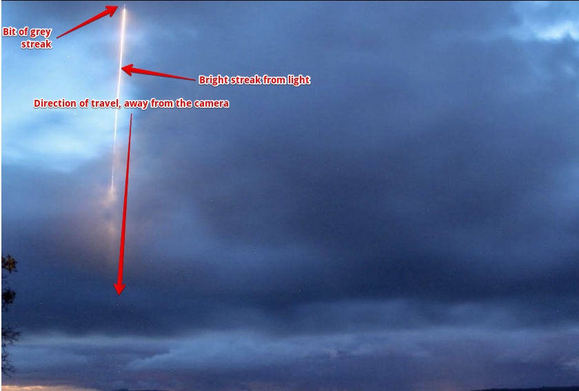
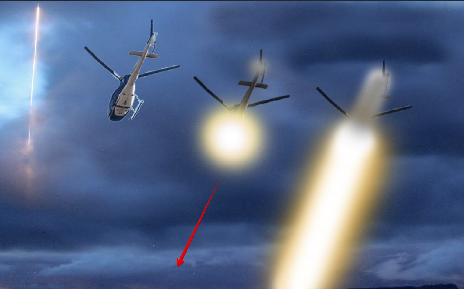
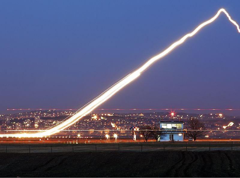
A more promising suggestion was that is was a helicopter, moving AWAY from the camera.


This was first suggested by Tyler Rogoway at The Drive, and subsequent analysis of ADS-B flight data confirmed that this was the correct explanation.


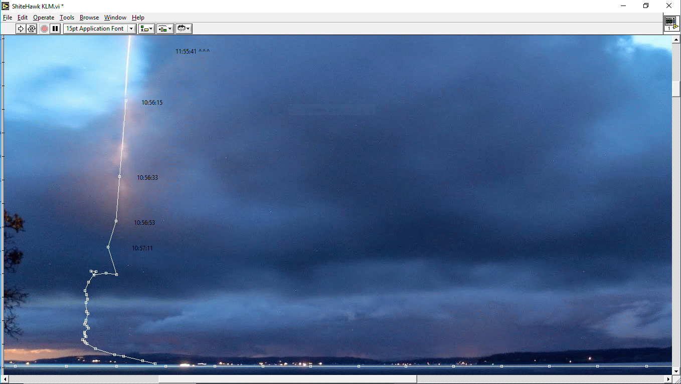
The grey streak being the dimmer light on the tail.


----------------------------------------------------------------------------------------------------------

Via Cliff Mass:
https://cliffmass.blogspot.com/2018/06/was-there-unannounced-missile-launch-on.html
Greg Johnson of Skunk Bay Weather on the northern Kitsap Peninsula has one of the most impressive weather cam facilities in the nation, including high quality digital cameras photographing the clouds at night. He is an extremely reliable weather observer.

But early Sunday morning he picked up something that is both startling and unexpected: what looks like a missile launch from Whidbey Island.

Here is the picture (with a 20-second exposure) at 3:56 AM Sunday morning from one of his cameras (looking north towards Whidbey Island). Can you see the bright vertical streak on the left side of the figure? Note the illumination both inside and outside the cloud. It really looks like the ascent of a rocket.
Content from External Source
The first thing to note is that it's a 20 second exposure, so what we are looking at is NOT a trail, but a streak of light from a moving light source, like a rocket, or a light on a plane.

Missiles.jpg

Sure looks like a rocket. However that's because it looks like a trail. It more likely a point of light.

The next thing to notice is that the "trail" gets bigger the higher it is in the image, which means that the object is moving towards the camera.

So I suspect it's simply a plane, with landing lights on, flying towards the camera, and quite possible descending.

Metabunk 2018-06-12 15-11-14.jpg

The grey streak of light in front of the bright light is probably one side of the fuselage, illuminated by the forward facing landing light.

The Landing light itself is off-center

The streak is red on the other side, possibly another light.
 
Last edited:
"Liembo" on the Cliff Mass Blog suggests Alaska Flight 94, which fits the bill, flying directly over Skunk Bay, which is exactly what is needed for this illusion.

Metabunk 2018-06-12 15-27-23.jpg

I'm not sure it moves enough in 20 seconds though. Depends on the vertical field of view of the camera.
 

Attachments

  • FlightAware_ASA94_PANC_KSEA_20180610.kml
    30.4 KB · Views: 830
That's a long trail for a 20 second exposure of a single light - not impossible - i can only guess how long it is - perhaps someone with Mick's "distance away towards the horizon" grid can do a bit of a calculation?

But at, say, 600mph - 10 miles/minute (16km/minute) one would expect it to be only 3.3 miles long - about 5.5km, and it certainly looks longer than that.

Yeah, maybe it's low. Those clouds only look 3,000 feet hight or so.
 
The camera is approximately at: 47.919894°, -122.579119°, looking north east, which eliminates ASA94


Metabunk 2018-06-12 16-24-12.jpg

Rough fit. Vertical FOV is about 20°.
 

Attachments

  • Skunk Photo.kmz
    2 KB · Views: 709
Looks like a plausible explanation here:
http://www.thedrive.com/the-war-zon...nch-over-whidbey-island-photo-from-washington
With this revelation in mind, the explanation of what you are seeing in the image is the helicopter moving away from the camera towards NAS Whidbey Island, just as it was tracked in the moments after the photo was taken.


When the image is interpreted in that fashion, you can see how the aircraft began being traced by the long exposure starting near the camera and moving away. As a result, it was also much closer to the camera, lower in altitude, and covered far less distance in the short 20-second exposure than a rocket blasting into the heavens far off in the distance would. At 115 knots the helicopter would have covered roughly 3,900 feet. The cloud it disappeared into would also be far closer to the camera when interpreting the image in this way. And all this actually works remarkably well just by shifting the notion of what you should be seeing in the image.
Content from External Source
Works for me.
 
You've got to invert more Mick:) It is going, not coming. It is (primarily) a light beam trace, not the trace of a moving light. As a FlightAware feed wallah, I have undetermined privileges which don't normally manifest themselves. My thought that you were able to delete faster than electric pixies can travel the information super-highway is probably bad! Here is the track for the under-privileged:

ps. My Google Earth broke when I last updated it, so I have not been able to look at the file.

Edit:
On the assumption that my link: https://uk.flightaware.com/live/flight/N952AL/history/20180610/0957Z
does not work for others, here is part of the Track log (Capture.PNG):
 

Attachments

  • FlightAware_N952AL___20180610.kml
    9.6 KB · Views: 763
  • Capture.PNG
    Capture.PNG
    72.6 KB · Views: 493
Last edited:
It looks as though there is a reddish tint to the left of the trail, which could add weight to the idea that it is flying away from the camera rather than towards it. (Or it could just be chromatic aberration from the camera lens.) Also if you assume that the bright light is at the front of the aircraft then it makes sense that the fainter light trail (from a tail light?) would start closer to the camera than the main trail.

upload_2018-6-13_11-1-35.png

Here's a video of an EC135 (very similar model) flying towards the camera.


Source: https://youtu.be/LjG1yKOGClk?t=2m18s


upload_2018-6-13_11-3-28.png
 
Last edited:
The camera is approximately at: 47.919894°, -122.579119°, looking north east, which eliminates ASA94


Metabunk 2018-06-12 16-24-12.jpg

Rough fit. Vertical FOV is about 20°.
Looks like a plausible explanation here:
http://www.thedrive.com/the-war-zon...nch-over-whidbey-island-photo-from-washington
With this revelation in mind, the explanation of what you are seeing in the image is the helicopter moving away from the camera towards NAS Whidbey Island, just as it was tracked in the moments after the photo was taken.


When the image is interpreted in that fashion, you can see how the aircraft began being traced by the long exposure starting near the camera and moving away. As a result, it was also much closer to the camera, lower in altitude, and covered far less distance in the short 20-second exposure than a rocket blasting into the heavens far off in the distance would. At 115 knots the helicopter would have covered roughly 3,900 feet. The cloud it disappeared into would also be far closer to the camera when interpreting the image in this way. And all this actually works remarkably well just by shifting the notion of what you should be seeing in the image.
Content from External Source
Works for me.

I'm still having great difficulty in visualizing the helicopter moving away from, rather than towards the camera. Shouldn't it be pointing downwards, rather than upwards, if it was flying away? Can someone explain the optical illusion here?
 
I'm still having great difficulty in visualizing the helicopter moving away from, rather than towards the camera. Shouldn't it be pointing downwards, rather than upwards, if it was flying away? Can someone explain the optical illusion here?
It's not "pointing" at all. What you are seeing are two streaks of light, a grayish white one (mostly hidden) and a bright yellow one.

The streaks of like come from the movement of the helicopter, and so if you can see the lights from behind, then it's flying directly away. But not necessarily up or down.

Metabunk 2018-06-13 10-21-02.jpg

Remember this is a 20 second exposure. You CAN'T see anything other than light streaks for a moving obejct (unless there's a flashing light, which can complicate things, like here)
 
Shouldn't it be pointing downwards, rather than upwards, if it was flying away?
The trail is basically just a roughly vertical line on the photo. Which direction it is "pointing" depends entirely on which end you treat as the front/top.

This is the end at the top of the photo, which is larger and appears to be closer to the camera:


You can either visualise that as a rocket with flame coming out of the back, or as the start of the headlight/searchlight, pointing downwards/away from the camera, with a smaller light on the back. The craft itself won't be visible because of the long exposure, so the illusion of a metallic "rocket" is just that: an illusion.


upload_2018-6-13_18-24-29.png
 
It's not "pointing" at all. What you are seeing are two streaks of light, a grayish white one (mostly hidden) and a bright yellow one.

The streaks of like come from the movement of the helicopter, and so if you can see the lights from behind, then it's flying directly away. But not necessarily up or down.

Metabunk 2018-06-13 10-21-02.jpg

Remember this is a 20 second exposure. You CAN'T see anything other than light streaks for a moving obejct (unless there's a flashing light, which can complicate things, like here)

The trail is basically just a roughly vertical line on the photo. Which direction it is "pointing" depends entirely on which end you treat as the front/top.

This is the end at the top of the photo, which is larger and appears to be closer to the camera:


You can either visualise that as a rocket with flame coming out of the back, or as the start of the headlight/searchlight, pointing downwards/away from the camera, with a smaller light on the back. The craft itself won't be visible because of the long exposure, so the illusion of a metallic "rocket" is just that: an illusion.


upload_2018-6-13_18-24-29.png

Well, that's what's puzzling me. The 'rocket' at the top was what I though was the helicopter, and that it was heading towards the camera, hence flying 'upward' in the 2D photo. If the helicopter is flying away, then it's at the bottom of the streak of light, flying 'downward' in 2D.

What's throwing me off is the grey 'rocket' at the top. What are we looking at here?
 
Last edited:
Well, that's what's puzzling me. The 'rocket' at the top was what I though was the helicopter, and that it was heading towards the camera, hence flying 'upward' in the 2D photo. If the helicopter is flying away, then it's at the bottom of the streak of light, flying 'downward' in 2D.
It's at the top, and the bottom, and all the way along the length of the line (although at the far end it is hidden in the clouds). It's a long exposure, so the trail marks out the distance it has travelled in that time.

My interpretation of the grey "rocket" is that it's the trail of a fainter light at the back of the helicopter. So the trail of that light starts closer to the camera (by the length of the helicopter) than the bright light at the front does.

It's like, was this tram was going from left to right or right to left? It's not easy to tell, although the headlights might be a clue.


OK, thanks. Time-lapses can be very disorientating! I assume that tram is travelling left to right, with the headlights disappearing from view as they come level with the camera on the right side of the photo. Is that correct?
 
My interpretation of the grey "rocket" is that it's the trail of a fainter light at the back of the helicopter. So the trail of that light starts closer to the camera (by the length of the helicopter) than the bright light at the front does.
Exactly, something like this:
Metabunk 2018-06-13 11-47-24.jpg
 
From Skunk Bay Weather https://skunkbayweather.blogspot.com/


This morning I contacted Air Lift NW to find out if the Nav lights on the helicopter were different in any way. I got a fairly quick response back from them after they talked with the pilot. Here is the text:

"They were transiting from Bremerton to Bellingham on a standard instrument flight plan, flying in the clouds with night vision goggles. The search light was retracted flush under the nose, but did not switch off and was facing straight down."

So, the path of the helicopter matches perfectly and now that I know the searchlight was in a locked down position and still on, it makes sense now.
Content from External Source
 
Last edited:
Exactly, something like this:
Im not certain about this; my interpretation would be that the helicopter was simply coming out of the clouds with the searchlight always on, the "metalic" streak would be therefore not the fainter positionlight at the rear but instead just the searchlight where the cloud is still blocking most of the light, but getting thinner at the edges, right?

edit:
scetch.jpg

I mean, why would there be a fainter streak from another, fainter light just for a small, specific lenght on the pic? its assumable that the searchlight outshines every other light on the helicopter due to long exposure and distance, even if we are looking at the underside and see mostly the complete lenght of the helicopter, this would only make sense if the searchlight was off and was turned on a few seconds after the helicopter entered the frame of the cam, but as statet, it seems it wasnt:
"They were transiting from Bremerton to Bellingham on a standard instrument flight plan, flying in the clouds with night vision goggles. The search light was retracted flush under the nose, but did not switch off and was facing straight down."
 
Last edited:
I had to fiddle the long to -122.587 to get a good fit with SHCC. MLAT is not very accurate anyhow.

If anyone has exact coordinates for the camera (to a few metres) I might be tempted to make a version of the unmetionable thing, referred to as SHCC, that inputs KML files, and overlays the track on a photo. I moved my house to Skunk Bay for the plot, but I left it at the same height, as I had no information on height. The points should probably be a bit higher in the sky as the camera is probably lower than mine.Capture.PNG
 
It would be an interesting twist if they were using a near-IR = NVG (Night vision goggles?) filter. on the searchlight.
I read somewhere that the camera was sensitive to IR.

Capture.PNG
 
Last edited:
I mean, why would there be a fainter streak from another, fainter light just for a small, specific lenght on the pic? its assumable that the searchlight outshines every other light on the helicopter due to long exposure and distance, even if we are looking at the underside and see mostly the complete lenght of the helicopter, this would only make sense if the searchlight was off and was turned on a few seconds after the helicopter entered the frame of the cam, but as statet, it seems it wasnt:

My assumption was that is the position of the helicopter at the start of the exposure: it is already in the field of view at the time the exposure begins. So the searchlight never covers that part of the frame at all.
 
My assumption was that is the position of the helicopter at the start of the exposure: it is already in the field of view at the time the exposure begins. So the searchlight never covers that part of the frame at all.
I see, you could be absolutly right and it makes sense and I wasnt thoughtfull enough about it. again :rolleyes:. what still bothers me is the pink glowing edges of the cloud, where the trail starts, and I assume that could only be the case if the helicopter was in fact coming out of the clouds. so, I am not totally convinced, but that detail really doesnt matter anyway, cause the case as a whole seems otherwise completly debunked ;)
 
Last edited:
Exactly, something like this:
My assumption was that is the position of the helicopter at the start of the exposure: it is already in the field of view at the time the exposure begins. So the searchlight never covers that part of the frame at all.

ok, I am convinced, youre both right...tried it with a flashlight and attached another, smaller one at the end of it to simulate the helicopter, all pretty sloppy but the result fits your explanation quite nicely; first photo shows flashlight with second "positionlight", second photo with exposure time 2 seconds, moving flashlight from top to bottom already in frame, when exposure starts (added "missile"-detail for comparison):

works1.jpg

thank you two for the lesson :p
 
Last edited:
Here is my first attempt of a .klm track overlay. I don;t have accurate data, and the picture will not fit on this laptop. Notice that the track is a bit longer than a 20 second blur would be.shcc-klm.PNGCapture.PNG
 
Last edited:
I don't have time to read through all the comments- and I'm not disputing the helicopter idea, but the instant I saw the image I thought it was possibly an airliner climbing out of Bellingham, WA (KBLI) or Vancouver Canada (CYVR) southwest bound, towards the camera, with the sun shining over top of the visible low clouds and illuminating the aircraft's persistent contrail.

I think that Vancouver is the place to start because that aircraft is probably too high to have just launched off of Bellingham.

[EDIT:
I just looked at the track in the post just above mine and realized that it DOES look like it comes from Bellingham or Whidbey NAS. Also, with the APPEARANCE of a single contrail, it is unlikely to be an airliner and more likely to be an E/F-18 Growler which has its two exhaust nozzles so close together it would appear as one.
I doubt that they ever use afterburner due to noise, but I could be totally wrong about that (particularly if they were simulating a scramble for training).
With regard to lights: if that's a light it's (obviously) on the centerline... which is not where most airliners have their lights (other than the taxi lights on the retracted nosegear). Though the 737's landing lights are under the belly in the center mounting in the wing-to-body fairing.
The E/F-18 probably does have a landing light on its centerline mounted on the nose gear, but (like the airliners) that would be retracted immediately after takeoff.

There are not too many jet departures daily out of Bellingham other than some Alaska/Horizon flights that I think are pretty rare. I'm not sure if Allegiant still has one flight out of there per day.
By the way, don't ever fly Allegiant- their maintenance is atrocious. They fired a captain for evacuating an MD-80 when a flight attendant reported smoke in the cabin because they had to pay to repack the slides.

I would start investigating on planefinder and/or flightaware, starting with flights from CYVR to Hawaii or Australia [EDIT PART 2: I'd start with Alaska flights from KBLI to Hawaii], but I'm currently trying to finish my exhaustive "chemtrail" debunking video which keeps growing in scope because there are so many lies to debunk. It's currently at 2 hours and 9 minutes and I am in the middle of subtitling the sections I chose to include of the Weather Modification.com pilot in the YouTube video "Hidden cam interview chemtrails pilot POISONING US".

That video totally debunks itself. And then the guy walks out of the place saying, "Well I think they are spraying ... that's what I believe." It is exactly like how George Noory of Coast to Coast AM dismissed me when I called in 2014 and explained all the science of contrails... after he got me off the line he said, "Well I think there is something going on up there. They are spraying something on us".
 
Last edited:
I thought it was possibly an airliner climbing out of Bellingham, WA (KBLI) or Vancouver Canada (CYVR) southwest bound, towards the camera, with the sun shining over top of the visible low clouds and illuminating the aircraft's persistent contrail.

At the time of the photo the sun was still 10 degrees below the horizon (sunrise was not until 5.11am). I don't think the sun could catch a contrail that early in the morning.
 
At the time of the photo the sun was still 10 degrees below the horizon (sunrise was not until 5.11am). I don't think the sun could catch a contrail that early in the morning.

Good point! Looking at the time may have been a good idea! :)
Having flown over Whidbey Naval Air Station on several occasions (with ATC permission!), it looks like the track plotted by CloudsGiveMeTheWillies goes precisely to it.
If the image is of that Northwest Airlift helicopter that would be logical because it is entirely possible that someone injured themselves somewhere on Whidbey Island and Northwest Airlift picked them up from the only suitable landing place at the NAS and took them to Harborview Hospital in Seattle (which is where they usually take everyone around here who has serious injuries or burns).

[EDIT: They have P-8s (737s) at NAS Whidbey now https://cnic.navy.mil/regions/cnrnw/installations/nas_whidbey_island/news/news_releases/18-037.html
 
I realize that the 20 second exposure gives the appearance of a long airliner-like fuselage where there is not really a fuselage, but because I think the color of the image looks like the grey of the P-8 (737), I did a search for "P-8 lighting" to see if there is a light on the tail (not expecting to find one)… and of course there isn't a big light on the tail, but interestingly there is a DIRC "Directional Infrared Counter Measures" on the tail...
http://www.b737.org.uk/mma.htm
Directional Infrared Counter Measures is a system produced by Leonardo, Elbit Systems, Northrop Grumman, ITT Corporation, and BAE Systems to protect aircraft from infrared homing man-portable missiles. It is a lightweight, compact system designed to provide mission-vulnerable aircraft with increased protection from common battlefield threats. It is more advanced than conventional infrared countermeasures.
 
Back
Top