Explained: Square in a NASA photo? [Centaur Landing Reference Grid]

George B

Extinct but not forgotten Staff Member
Last edited by a moderator:
...perhaps a highlighted area to examine ?
The caption says, ".....(they) review early results from the centaur and spacecraft impacts.

You seem to think this rectangle is "raw data".
Is it ?
Why not write them and ask them about the photo ? Answers are often there, if you investigate before accuse.

http://www.hq.nasa.gov/office/pao/FOIA/agency/
 
There's an extensive discussion of that photo here:

http://www.abovetopsecret.com/forum/thread819278/pg1

With an explanation from Anthony Colaprete (whose arm is resting on the photo in question):

From: Colaprete, Anthony (ARC-SST)
To: me
Date: 3/16/2012 12:23:11 AM
Subject: RE: Please solve a mystery

Hi Edward,

Sorry for the slow reply, I have been in a workshop the last couple days and am way behind on email.
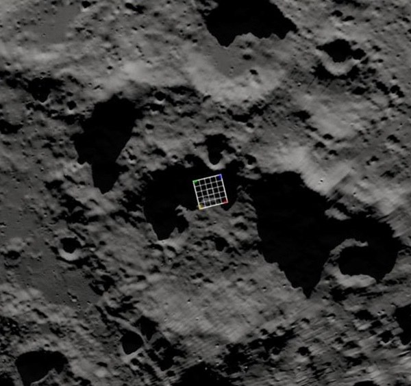
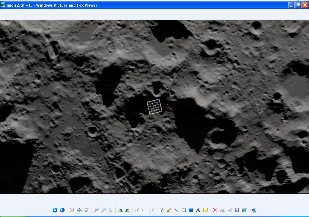
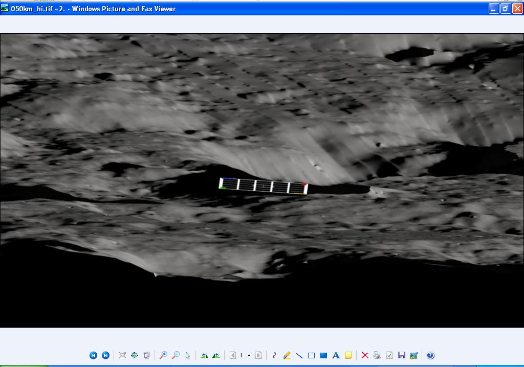
First off, the image isn’t staged! It was taken during the final descent of the Centaur stage to the moon. Kim and I (and another person behind us) are in the Science Operations Center (SOC) for LCROSS. What Kim and I are looking at are displays of our instrument data (cameras, spectrometers, etc….several of the camera feeds we streamed real-time to the web during the mission). The image of interest is a simulation of the moon’s surface generated from a digital elevation model and illumination models. It was made prior to the impact of the Centaur with the same lighting conditions as those at the day/time of impact. We knew where we wanted to impact (based on our expectation of the most likely location of hydrogen/water), but there was some uncertainty as to exactly where we would actually impact. We had a number of observatories on the ground (for example in Hawaii) trying to look for the impact plume (most didn’t see it, but some did) and we wanted to be able to tell the observatories if they needed to adjust their pointing based on the actual impact location. To do this we placed a grid on the image and provided the same grid to the observatories (in the perspective they would see it from on the ground). At the time of impact flash or plume detection in our cameras I was to identify the grid point and call it out to the person behind me (the person behind me was in direct communication with all the ground observatories, coordinating that part of the observation)…sort of like calling out a letter/number in bingo. The image with grid and the one corresponding to the view as seen from Hawaii on that night is attached to this email.

So, no it is not a base, but rather just a reference grid, and that watch has since broken, so I wouldn’t recommend it. I hope this helps.

Tony
Content from External Source
 
Last edited:
Debunking tip: use an online image search, like Google Images. Save the image on your desktop, then drag it into Google Images, and then you can see if other people have already debunked it.
 
There's an extensive discussion of that photo here:

http://www.abovetopsecret.com/forum/thread819278/pg1

With an explanation from Anthony Colaprete (whose arm is resting on the photo in question):
Dear Mister West,

Although it has been several years this picture made some disturbance in the UFO scene, I would like to add something to it. First and foremost this is not the way to debunk something. You have done no proper research and also took the explanation from a NASA employee for granted. Let me address the following. You have to understand that NASA doesn't use any grid patterns anymore to pinpoint a specific location on the lunar surfacve since the mid seventies after they mapped the whole lunar surface in a incredible detailed way. How I know? A very good friend of mine was a frame engineer through the nineties at NASA. So let's assume the grid is not being used, what is it what we are seeing? As being a former environmental engineer I can see more anomolies that are being out of place and not do not represent natural shapes. I have examined this picture together with some technical engineers and what we see more is that the grid shows depth. However your debunk tip does not make up for the fact you should take it for granted by stating that this is the result from a simple drag and drop. Now as far as it goes for the depth in the grid we see light coming from the north east that reflects the surface as it does for the the rooftop of this structure. We measured the light strength on this picture and the conclusion is that the light of the rooftop has the same strength as the surroundings. The shadow on the rooftop has the same angle as the shadows in the environment.

Then in the left corner of the structure we see another structure that resembles the same features with perfect angles. Nature doesn't build in perfect angles. Another issue is the picture itself. If you plot a grid on a grainy picture the grid itself is sharp and detailed. This so called grid has the exact same grainy look as the rest of this picture. That should not be possible. And the last thing I would like to add is that this so called structure cast its own shadow on the lunar surface. Our conclusion is that there are several structures on this pictures, no grid is being used, light and shadow are undeniably there, light strength is the same as the exact grainy overall look of this picture. I am not here to attack you, but just want to show you a different perspective to look at this.

 
Last edited by a moderator:
You have to understand that NASA doesn't use any grid patterns anymore to pinpoint a specific location on the lunar surfacve since the mid seventies after they mapped the whole lunar surface in a incredible detailed way. How I know? A very good friend of mine was a frame engineer through the nineties at NASA.
Unless you can back that up, then the rest of your post is irrelevant. Remember this is specifically for identifying a landing spot based on a video image. How else would they do it?

To do this we placed a grid on the image and provided the same grid to the observatories (in the perspective they would see it from on the ground). At the time of impact flash or plume detection in our cameras I was to identify the grid point and call it out to the person behind me [...] …sort of like calling out a letter/number in bingo.
Content from External Source
Colaprete also supplied the images from the 3D model (from which the photo came)


It's quite obviously just a reference grid.
Metabunk 2019-05-11 09-27-04.jpg


But if you wish to continue to make a case, I'd encourage you to use images, and not descriptions. It really not clear what you are referring to.
 
Unless you can back that up, then the rest of your post is irrelevant. Remember this is specifically for identifying a landing spot based on a video image. How else would they do it?

Plus, even if true, it isn't relevant. "Through the nineties" isn't particularly useful when referring a program that stood up in 2004. Plenty of time to start doing things differently, especially when considering that LCROSS was a sister mission to LRO's mapping project.
 
@Robbert

“You have done no proper research and also took the explanation from a NASA employee for granted. Let me address the following. You have to understand that NASA doesn't use any grid patterns anymore to pinpoint a specific location on the lunar surfacve since the mid seventies after they mapped the whole lunar surface in a incredible detailed way. How I know? A very good friend of mine was a frame engineer through the nineties at NASA. ”

Interesting how while chastising Mick for taking the word of a NASA employee you do the exact same thing.
 
Back
Top