Oroville Spillway Investigation and Repair

Status
Not open for further replies.
That doesn't mean there is any federal money.
I don't understand why you are saying this. What am I misunderstanding about the "disaster declaration approved" notice?

Assistance for State, Tribal, and Affected Local Governments Can Include as Required:

  • Payment of not less than 75 percent of the eligible costs for debris removal and emergency protective measures taken to save lives and protect property and public health. Emergency protective measures assistance is available to state, tribal and eligible local governments on a cost-sharing basis. (Source: FEMA funded, state administered.)
  • Payment of not less than 75 percent of the eligible costs for repairing or replacing damaged public facilities, such as roads, bridges, utilities, buildings, schools, recreational areas, and similar publicly owned property, as well as certain private non-profit organizations engaged in community service activities. (Source: FEMA funded, state administered.)
  • Payment of not more than 75 percent of the approved costs for hazard mitigation projects undertaken by state, tribal, and local governments to prevent or reduce long-term risk to life and property from natural or technological disasters. (Source: FEMA funded, state administered.)
Content from External Source
There has only been an EM declared
I don't understand why you are saying this. What am I misunderstanding about the "disaster declaration approved" notice?

Assistance for State, Tribal, and Affected Local Governments Can Include as Required:

  • Payment of not less than 75 percent of the eligible costs for debris removal and emergency protective measures taken to save lives and protect property and public health. Emergency protective measures assistance is available to state, tribal and eligible local governments on a cost-sharing basis. (Source: FEMA funded, state administered.)
  • Payment of not less than 75 percent of the eligible costs for repairing or replacing damaged public facilities, such as roads, bridges, utilities, buildings, schools, recreational areas, and similar publicly owned property, as well as certain private non-profit organizations engaged in community service activities. (Source: FEMA funded, state administered.)
  • Payment of not more than 75 percent of the approved costs for hazard mitigation projects undertaken by state, tribal, and local governments to prevent or reduce long-term risk to life and property from natural or technological disasters. (Source: FEMA funded, state administered.)
Content from External Source
The key component is debris removal and emergency protective measures. No repair is mentioned.
 
yea but if they had said to y'all prior to the hole issues.. "This spillway has serious issues, we need a major and complete repair to update it to current standards and prevent long term future failure" you'd be facing almost the same pricetag (minus debris work. plus excavation that the collapse provided free of charge) you are now.

At least this way the feds are helping you out more than if you took care of your infrastructure yourself in a timely fashion.

Your repair estimate assumes that the spillway would have needed to be replaced to the extent it is now scheduled to be, regardless of the recent incident... Croyle has used the analogy of a car in a few of the press conferences, and it seems fitting. Oroville Dam and its structures are like a car in that they require constant monitoring and maintenance. As a car (or dam) ages, many potential issues can be averted by watching for wear and tear and replacing parts before they completely break and cause larger problems... Of course some things are more difficult to monitor than others, but until (and if we ever) we learn the cause of the spillway failure, I am not so sure it was entirely unavoidable...

Top officials at the DWR are gubernatorially appointed, and there is a decade or so long history of contention between the DWR and local officials and citizenry, at least in Butte County. Some of these issues are apparent in the relicensing documents, and the dragging on for years now of the relicensing process. A long list of critical Enterprise Record editorials and articles. Prior accidents at the Oroville site. Instances when standard operating procedures were not followed...

The three most recent inspection reports also illustrate some of the problems locals have with the management of the dam structures.

2014: "The river valve system (RVOS) was recently rehabilitated and tested for discharges of up to 2500cfs...the system is now operated and monitored remotely" (pg 3 here:
https://www.documentcloud.org/documents/3458959-Oroville-Dam-Inspection-Report-June-2014.html )

2015: "As previously noted, the river valve syatem (RVOS) has been rehabilitated and tested for discharges up to 2500cfs...Nothing unusual of mechanical nature was observed in the outlet chamber. We could not access the deck beyond the pressure relief wall to observe the rehabilitated H-B valves. We did note that two new H-B valves had been stored in the powerhouse." (pg 3 here: https://www.documentcloud.org/documents/3458958-Oroville-Dam-Inspection-Report-2015.html )

2016: "The new low level outlet baffle ring has been installed and tested using the original valves. The combined release was 4,000cfs. Testing delays were caused by electro-magnetic issues. Manufacturing defects have delayed the installation of replacement valves. The schedule to install new valves is uncertain." (pg. 3 here:
https://assets.documentcloud.org/documents/3458956/Oroville-Dam-Inspection-Report-August-2016.pdf)

All 3 reports also mention seepage at the dam and repeatedly state: "A plan for long-term monitoring of the phreatic surface within the dam embankment needs to be developed and implemented." (pg 1 in all reports). Here we are, 4 years after the first report...

What else has not been monitored and maintained? Could thorough monitoring have caught the issues that ultimately caused the spillway failure and allowed for timely repair or partial updates, instead of the current total replacement?
 
Last edited:
There's a whole lot of speculation without foundation. Was there ever a prior recommendation to bring the spillway up to modern specs--thicker, overlapped concrete, etc? If not, claims about shovel-ready are premature.
 
What else has not been monitored and maintained? Could thorough monitoring have caught the issues that ultimately caused the spillway failure and allowed for timely repair or partial updates, instead of the current total replacement?

my guess is yes. but my point was more that eventually (say over the next 20 or 30 years) lots of minor and major repairs would have needed to be done. And piece work usually costs more. It's only my personal opinion of course, but I think a nice new spiffy spillway now (with much cost deferred to the fed gov) is kinda a blessing. But again that's just my opinion.

No repair is mentioned
I see. I thought that fell under the 'hazard mitigation' section.
 
Press conference shows "concept" plans for new spillway. The plan for the emergency spillway in particular is ambitious. It also means removing all the concrete they've put (slopped?) in to date.

Source: https://www.youtube.com/watch?v=QAY-4-NeB18

has some images from the conference.

Here is a screenshot from 3:26 in the Juan Browne video linked above, which shows the basic proposal at this stage for weir/emergency spillway reinforcement. It does look as though they will have to excavate below the shotcrete placed on the surface of the slope below the weir in order to reach "bedrock" (whatever exactly that means in this area) in order to found the the roller compacted concrete buttress and "splash pad" between the buttress and the downstream cutoff wall:
EmergencySpillwayProposal.jpg
I imagine (although there's unlikely to be confirmation of this from DWR unless and until they start releasing more information) that this plan was formulated after the Board of Consultants inspected the site and provided their initial recommendations last month - that is to say weeks after DWR had already started their own emergency reinforcement measures. It isn't hard to understand why their initial measures have been overtaken after further investigations.

The extent of the work already carried out and proposed for this part of the facility strongly suggests that however many statements are made about not ever using it again DWR can foresee circumstance in which there might be no option. Mr Croyle has said as much in at least the last three press briefings.
 
So, what happens when the Emergency Spillway wall to the left (looking toward the lake from dam) of the weir is overtopped again and its base gets eroded? Anyone seen anything about what DWR has planned for that area? If the weir needs work, it would seem to me that the wall needs more.
 
So, what happens when the Emergency Spillway wall to the left (looking toward the lake from dam) of the weir is overtopped again and its base gets eroded? Anyone seen anything about what DWR has planned for that area? If the weir needs work, it would seem to me that the wall needs more.

See:
http://www.water.ca.gov/oroville-spillway/pdf/2017/a3186 Oroville Spwy Recovery_v5.pdf
20170409-082102-jn4ux.jpg
The current design being pursued for the emergency spillway:

• Place a concrete wall beneath the ground and deep into rock downstream of the existing weir. This type of construction is common in dam engineering and is usually referred to as a cutoff wall to prevent “head-cutting” erosion at the base of the concrete weir if the emergency spillway had to be used.

• Place RCC against the existing weir. This is common to dam engineering and normally referred to as buttressing the dam to ensure the structural integrity of the weir under flood flows and future possible seismic loading conditions.

• Place RCC downstream of the weir to convey flood flows downstream. This is commonly referred to as an RCC apron used to prevent erosion of the bedrock.

The construction schedule has been developed to ensure that the concrete cutoff wall, the most critical component, will be completed by November 1.
Content from External Source
So basically erosion would be anticipated below the downstream cutoff wall, but the cutoff wall (set deep in the bedrock) would prevent that causing any structural problems.,
 

Attachments

  • a3186 Oroville Spwy Recovery_v5.pdf
    593 KB · Views: 836
See:
http://www.water.ca.gov/oroville-spillway/pdf/2017/a3186 Oroville Spwy Recovery_v5.pdf
20170409-082102-jn4ux.jpg
The current design being pursued for the emergency spillway:

• Place a concrete wall beneath the ground and deep into rock downstream of the existing weir. This type of construction is common in dam engineering and is usually referred to as a cutoff wall to prevent “head-cutting” erosion at the base of the concrete weir if the emergency spillway had to be used.

• Place RCC against the existing weir. This is common to dam engineering and normally referred to as buttressing the dam to ensure the structural integrity of the weir under flood flows and future possible seismic loading conditions.

• Place RCC downstream of the weir to convey flood flows downstream. This is commonly referred to as an RCC apron used to prevent erosion of the bedrock.

The construction schedule has been developed to ensure that the concrete cutoff wall, the most critical component, will be completed by November 1.
Content from External Source
So basically erosion would be anticipated below the downstream cutoff wall, but the cutoff wall (set deep in the bedrock) would prevent that causing any structural problems.,

Thanks, but all this relates to the weir, all three bullet points mention it. Have they said this plan will extend the entire width of the Emergency Spillway, all 900 or whatever feet of it?
 
Thanks, but all this relates to the weir, all three bullet points mention it. Have they said this plan will extend the entire width of the Emergency Spillway, all 900 or whatever feet of it?

I think it's pretty obvious that it must do. The section of the Emergency Spillway that goes along the front of the parking lot and under the hillside is just another type of weir, top level with the ogee weir. Water flows over the entire length evenly.

Local details will vary though. It's a very "high concept" plan.
 
2 recent articles with input from respected geologists blame both spillways' problems on original designs not taking into account weathered/ erodible nature of much of both spillways' "bedrock":

The destruction of Oroville Dam’s main spillway in February likely occurred because it was built on highly erodible rock, according to several experts interviewed by Water Deeply. If confirmed by a forensic investigation now underway, rebuilding the spillway will require a much more expensive and time-consuming effort.
Content from External Source
https://www.newsdeeply.com/water/ar...-have-been-caused-by-weak-soil-under-spillway

[re emergency spillway supposedly rated to handle 20-30X what flowed over it in Feb:]
“I find that astounding that they would rate it like that,” says [Eldridge] Moores. “It seems to me that even a student of geology could have told them that they were going to have an erosion problem here.”
Content from External Source
https://ww2.kqed.org/science/2017/04/07/how-incompetent-rock-led-to-the-oroville-dam-crisis/

The first article states that fifty years ago the problem of "saprolite" underlying dams wasnt [well?] understood by designers, and links to a pretty interesting paper on the Taum Sauk dam disaster (though its failure was mostly caused by what seems like criminal idiocy/ ignoring clear warning signs).

But the second article quotes some original documents relating to Oroville Dam as showing that the designers knew about incompetent rock in the area, and designed for/ around it for the main embankment wall, but apparently ignored it in designing the spillways.
 
Not that it's a wrong thing to do, but they sure are spending a lot of expense and effort to shore up an emergency spillway which they are determined to never use. It feels like their investigations haven't increased confidence in the original weir stability.
 
Not that it's a wrong thing to do, but they sure are spending a lot of expense and effort to shore up an emergency spillway which they are determined to never use. It feels like their investigations haven't increased confidence in the original weir stability.

It's impossible to 100% prevent the usage of the emergency spillway. We are probably towards the end of the rainy season now, but if there's a strong series of storms next season (2017-2018) then it might be needed again.
 
Last edited:
Not that it's a wrong thing to do, but they sure are spending a lot of expense and effort to shore up an emergency spillway which they are determined to never use.

Not using it again is something like the party line but realistically it's hard to accept that they can be so absolute about it. Aside from anything else, Mr Croyle has said more than once that the option of using the emergency spillway if DWR have to is on the table.

They must be hoping for a very dry spell between May/June and November when repairs to the main spillway will probably put it out of action.
 
It was known 50 years ago that top layers of rock were incompetent. The building standards back then were definitely less stringent.

The standard at that time was to remove incompetent rock until you get down to bedrock, then build up from there. The standard nowadays is to go 4 feet down into bed rock, then build up with concrete. This 4 feet allows that base to have downhill push against solid rock to keep the structure from getting pushed off its base. Otherwise you are just relying on the friction weight of the structure and the weight of the incompetent rock.

After seeing what the water over the emergency weir did to the incompetent rock, it only makes sense that they are rebuilding the main spillway structure and buttressing the emergency spillway to modern construction practices. Also the development of Roller Compacted Concrete has provided a material that has a way better cost, and is way faster to lay.

The additional emergency work they have done to the emergency spillway makes it available if absolutely necessary. Once you get to dry season, California is super dry. The Hyatt will remain running. Once inflows stop they will draw the lake well below the 835 level.

That will give them a lot of time to replace the main spillway structure. It sounds like the plan is to leave working part of spillway in place . In parallel they will remove and replace main spillway structure, and fill the broken part that is the first void.
 
Once you get to dry season, California is super dry. The Hyatt will remain running. Once inflows stop they will draw the lake well below the 835 level..
Yes (the dry season typically has already started by now, and we essentially get zero rainfall in CA over summer). But inflows won't stop when the rain stops. There's much higher than normal snowpack in the Sierran watershed behind the dam. The spring thaw lasts way into the summer in the mountains. I suppose it's known what typical inflow rates are from a given snowpack, but if the weather happens to get atypically warm fairly soon up there? Can they predict runoff rates from the thaw as reliably as we can predict that it essentially doesn't rain in CA in the summer? I imagine it'll take some time for the Hyatt to draw lake levels down at 10-12 cfs outflow when all that spring/summer melt is coming in.
 
They are planning on running the spillway at least once more. They are hoping to get by on that one more spill. But if the snow does not melt before that spill ends, there will be a late May early June spill. Those 2 spills should take care of any snow melt and any additional rains. After that, all indications are that flows will drop well below 5k, and they should be able to draw the reservoir down significantly.
 
It's impossible to 100% prevent the usage of the emergency spillway. We are probably towards the end of the rainy season now, but if there's a strong series of storms next season (2017-2018) then it might be needed again.

I'm sure there are protocols buried in the S.O.P. somewhere for use of the emergency spillway. But I wonder if maybe the original engineers only intended that spillway to only be used in some sort of doomsday scenario. When construction began on the dam we were deep in the middle of the cold war and engineers might have envisioned a scenario where we were attacked and no one would be around to monitor the lake levels and release water accordingly. If the emergency spillway (dam) did fail after days or weeks of use, at least the main dam would be saved.
 
It was known 50 years ago that top layers of rock were incompetent. The building standards back then were definitely less stringent.

The standard at that time was to remove incompetent rock until you get down to bedrock, then build up from there. The standard nowadays is to go 4 feet down into bed rock, then build up with concrete. This 4 feet allows that base to have downhill push against solid rock to keep the structure from getting pushed off its base. Otherwise you are just relying on the friction weight of the structure and the weight of the incompetent rock.

I haven't found the historical records of the spillway construction very comprehensive and how far they are reliable is open to question. Nonetheless this extract from the California State water Project Bulletin No. 200 is (a) consistent with the comment cited above and (b) hints (but no more) in a couple of passages at the existence of areas that in hindsight should have been more deeply excavated. Note that there is no reference to finding such large areas of incompetent rock as have been revealed since the spillway deck was breached (italics added to the extract):

Excavation. The three major methods used to excavate the spillway were as follows: bottom-loading scrapers and pushcats, a loader with cats feeding the belt and bottom-dump wagons hauling the material, and two large shovels.

In general, the scrapers were used to strip the area to rock. The shovels were used to excavate the rock after it was drilled and shot
. The loader was used similarly to the scraper operation, the main difference being that it was possible to work this operation in rougher terrain as up to eight dozers were used to push material to the feeding hopper. A road was graded out below the hopper and the bottom-dump wagons could drive under the hopper to load.

All drilling for blasting was done by percussion-type drills mounted on tracks and powered by air. The patterns varied greatly from area to area. The most generally used pattern was 8 by 8 feet; however, patterns ranging all the way from 2'/2 by 2/4 feet to 15 by 15 feet were used depending on the area, type of rock, and excavation objective. Excavation near structure lines had to be controlled to avoid damage to the rock to be left in place, and 840,000 tons of riprap for Oroville Dam had to be produced.

Approximately 90% of the chute foundation required blasting to reach grade. The only extra excavation directed was removal of a few clay seams in the foundation and a few areas where slope failures occurred.
Content from External Source
In terms of related repair efforts, the latest photos added to DWR's photo gallery (https://pixel-ca-dwr.photoshelter.c...NchE/DK-oroville-spillway-7615-04-10-2017-jpg) show the construction of stair access to the plunge pool/ravine and additional shotcrete being applied in that area. Although the reservoir level is rising steadily and at least one or two more spills between now and June have been mentioned in past DWR press briefings, from the work now being carried out it does not seem that another spill is imminent.

DK_oroville_spillway_7635_04_10_2017.jpg
DK_oroville_spillway_7615_04_10_2017.jpg
 
Article reference below:
"A 1961 planning document for Oroville Dam says the site is “blessed with a geologic 
structure and foundation rock which are suitable for the foundation.” It also suggests excavating down 18 feet to clear away “soil and weathered rock” for the main body of the dam. So it’s clear that builders working for the state were aware of the “incompetent” rock that’s prevalent at the site, but it’s less clear that similar excavations were suggested, let alone required for the spillways, which sit off to the side of the main dam."
Content from External Source
Though the dam was completed nearly 50 years ago, Moores says the rock at the site would have already been substantially decomposed, as the weathering process takes place over hundreds or thousands of years.

The emergency weir spilled at 12,500 and experienced failure levels of erosion. It was designed to spiill at 20-30x that rate.

https://ww2.kqed.org/science/2017/04/07/how-incompetent-rock-led-to-the-oroville-dam-crisis/
 
Last edited by a moderator:
Latest DWR photos (taken yesterday and posted today) show shotcrete being applied in the upper part of the plunge pool. If they continue doing so down to the bottom of the pool that is consistent with what Mr Croyle mentioned would be done before the last spill. But it's hard to know whether this is an exercise in preventing further erosion in that area or creating a surer footing for personnel and machinery that will be there when regular concrete and RCC is laid in due course. Second photo also gives an indication of how weathered the brown/orange rock actually is:

DK_oroville_spillway_7661_04_10_2017.jpg

DK_oroville_spillway_7641_04_10_2017.jpg
 
The successful (lowest) bidder for the spillway repair project has been chosen: http://www.capradio.org/articles/20...ins-bid-for-oroville-spillway-repair-project/

Construction work on the spillway repair project at Lake Oroville is expected to start soon as the Department of Water Resources has chosen a contractor.

Kiewit Infrastructure West, a Nebraska-based construction company, won the contract with a bid of roughly $275 million.

This was near $44 million more than the state's estimate, but it was still the lowest of the three bids submitted.
Content from External Source
Here's the text of the official announcement - I've no idea what the "error" of $220,100,00 in the state's original cost estimate was: http://www.water.ca.gov/news/newsreleases/2017/041717_oro_contract_award.pdf

Of course the plans for what the successful bidder will do are still substantially incomplete.

BTW, at some point the results of the forensic team's investigation into the cause(s) of the spillway failure will be announced and at the last DWR press briefing last week it was stated that the report will be released to the public. I reckon that DWR already have a shrewd idea of the cause(s) and have done for a while but it's the forensic team's remit to give the official explanation.
 
Last edited:
Looks to me after a close read of his article that the good UC Berkeley Professor plagiarized a lot of his report and presented pictures that were also posted on this MetaBunk .org forum over the past couple of months on the subject.

http://documents.latimes.com/report...ance-defects-oroville-dam-emergency-spillway/

I have to agree! I've been lurking for a while on this forum and whilst consolidated, nothing new was mentioned that hasn't already been posted here. Thanks to the contributors to the forum, it's made for very interesting reading.
 
Looks to me after a close read of his article that the good UC Berkeley Professor plagiarized a lot of his report and presented pictures that were also posted on this MetaBunk .org forum over the past couple of months on the subject.

http://documents.latimes.com/report...ance-defects-oroville-dam-emergency-spillway/
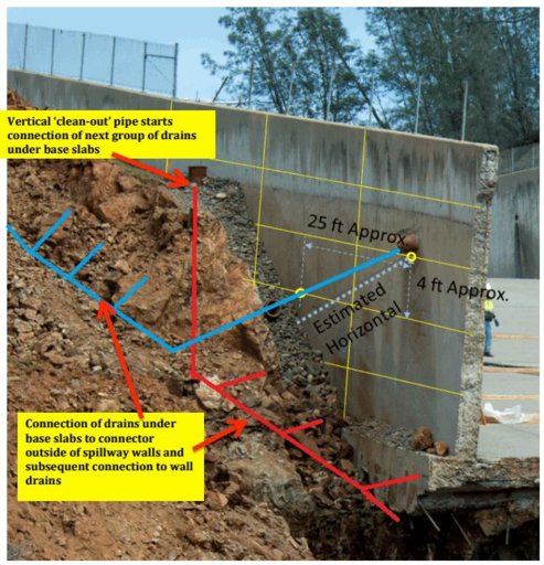
One that stuck out like a sore thumb was page 18/11 (18 of the PDF, page numbered 11) which had the following picture:
annotated.JPG
That appears that he took sweepleader's picture and added two text boxes:
Is there another version of that document that has sources listed? If not, it might be interesting to see what UC Berkley's position on plagiarism by their professors is...

I have to agree! I've been lurking for a while on this forum and whilst consolidated, nothing new was mentioned that hasn't already been posted here. Thanks to the contributors to the forum, it's made for very interesting reading.
There are a couple of things that I hadn't seen (like the lower left (when looking up the spillway) slab rotating downhill and the left edge separating at the wall) but most of it has been hashed out on here.

Aaron Z
 
One that stuck out like a sore thumb was page 18/11 (18 of the PDF, page numbered 11) which had the following picture:
annotated.JPG
That appears that he took sweepleader's picture and added two text boxes:

Is there another version of that document that has sources listed? If not, it might be interesting to see what UC Berkley's position on plagiarism by their professors is...


There are a couple of things that I hadn't seen (like the lower left (when looking up the spillway) slab rotating downhill and the left edge separating at the wall) but most of it has been hashed out on here.

Aaron Z

Apparently, the Professor has rather sloppy attribution skills. It would have been awesome to see a footnote crediting the picture above to sweepleader.
 
Well, in truth, the image is a crop from a DWR photo, only the colored lines are the work of SweepLeader, but I read the entire report and kept seeing all these photos and concepts that had been built here through our discussions.

I was humored - seems we at least have a professional who agrees with our armchair work.

Brad
 
I too have been tracking the spillway here since very early on, and agree that part of the referenced document are familiar. One image however which I do not recall from here (doesn't mean it isn't here) is this one.

upload_2017-4-19_9-10-54.png
indicating structural layers and the probability of water beneath the slab.

But overall, I think we've always known that this spillway construction experienced a lot both cut and fill, and that the "bedrock" was not homogeneous. Yet, what else is to be expected in the mountains? It's an imperfect scenario which was likely exacerbated by the recent extreme moisture swings.

Maybe they should remove most of the spillway and let a few heavy spills continue to "powerwash" the subsurface before proceeding. :)
 
One that stuck out like a sore thumb was page 18/11 (18 of the PDF, page numbered 11) which had the following picture:

That appears that he took sweepleader's picture and added two text boxes:

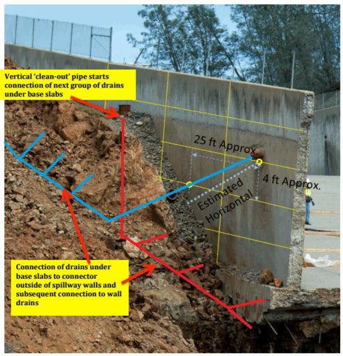
This one stuck out for me too, but it is really wrorke's work on a cropped DWR photo that I started with. And it was AlmostaCE's comments that caused me to illustrate this version of the drains. There, now it is all atributed properly, maybe.

Should have been credited to Metabunk.org in my opinion.
 
Well, in truth, the image is a crop from a DWR photo, only the colored lines are the work of SweepLeader, but I read the entire report and kept seeing all these photos and concepts that had been built here through our discussions.
I was humored - seems we at least have a professional who agrees with our armchair work.
Brad
True, the original photo is from the DWR, but the additional lines should have been credited to sweepleader/Metabunk or he should have redone them with his own lines (I am fairly certain some of the other annotated pictures also came from here, but that one stuck out like a sore thumb).

Aaron Z
 
I emailed the Center for Catastrophic Risk Management at UC Berkeley about this and got the following response (quoted verbatim from the email I received):
Hi Aron Z,

Rune Storesund (ccd this email) forwarded your email to me.

you are correct about the source of the photographs you cited. i obtained these from the metabunk forum web site.

due to limitations on the time i could devote to producing my preliminary report (all done pro-bono), i was not able to cite the many sources i used to obtain the photographic documentation included in the report.

i found the metabunk forum web site to be very useful in helping me develop a basic understanding of how and why the spillway failures developed. i would appreciate it if you could communicate my apology and reason for not citing the metabunk source for the photographs you cited.

Bob Bea

--
Robert Bea
Professor Emeritus
Center for Catastrophic Risk Management
University of California Berkeley
Content from External Source
Aaron Z

Yeah, I guess "Metabunk.org" is pretty hard to spell, eh? Much harder than DWR. :{)
 
Professor Bea's report has been picked up by other print media such as the Sacramento Bee and in interviews he's added a bit to his comments in such text as there is in the report:

http://www.mercurynews.com/2017/04/...ay-emergency-developed-and-propagated-by-dwr/
Most of the 78 pages consist of pictures and diagrams with text and arrows highlighting issues. The first few pages, however, lay out the conclusion Bea reached that the disaster was “developed and propagated by DWR during the gated spillway design, construction and maintenance activities.”

“I’m interested in what happened, with another motive of why, with another motive of how to prevent it in the future,” Bea said in a telephone interview Tuesday.

Research consisted mostly of studying photographs from DWR and media organizations including this newspaper, but Bea also had a chance to visit the Oroville Dam as a guest of the state water agency.

“We told them what we were doing. We got good responses with one exception,” Bea said.

That exception was inspection documents. The former professor used his research contacts to build a “gradual accumulation of the documentation background,” he said.

Bea reached several conclusions.

“The excuse list is terrifyingly long,” he said.
Content from External Source
By "inspection documents" I take him to mean the records of DWR's own inspections and repair decisions rather than the annual regulatory reports that are in the public domain and listed in the report.

It will be interesting to see if the Oroville independent forensic team come up with anything different or whether they endorse any significant part of the "excuse list."

(Also Juan Browne has done a video largely on the report - I don't link it here as it really only repeats what the report says.)
 
I for one wanted to note how lucky Oroville, DWR and everyone else was that they had Director Coyle on board that disastrous night. When the water started over the emergency spillway and the erosion was apparent immediately. It would have been massively stressful. Calling for the evacuation of town at the same time. Then someone has to throw out the idea, "we need to reopen the main spillway".

It is clear now, in hindsight, when they reopened the main spillway they saved that structure and that town. I am sure in the heat of that moment, that was not so clear. They kept level heads, and managed with what data they had in hand. There was certainly a bit of luck that the remaining spillway structure and enough solid rock to handle the flows.

Every decision the response team has made sense, seems from what is available, to have been great decisions. Closing the Hyatt at the right times. Pushing massive debris removals. Anchoring and shotcrete on the remaining spillway. Armoring the emergency spillway. All seem, in hindsight, to have been done in the right order at the right times, to create more options as they went along.

I take a slight exception with the AP article's headline

AP Exclusive: Managers made errors in handling of dam crisis
Content from External Source
(link for reference: below). I do not think there was much wrong in the 'handling' of the crisis. I realize this is like editors/authors trying to come up with a sensationalized headline. Just feel it does not quite convey the correct sense.

Sure there was a lot wrong with the operations and maintenance of the structure that led to the crisis. That has been well documented, discussed here. The overall handling of the crises once the hole appeared in the deck, seems pretty good.

ref:
https://apnews.com/0a4b46c359444c58918ad374f7cd3d28
 
OK, so he thinks there was erosion under the slabs, and the massive failure was due to slabs being lifted (and destroyed) by the water flow. Will be interesting to compare to whatever the official report decides.
He says something more than that, including that cracking of the spillway deck over the drain system shows that there was inadequate depth of concrete used, that the main deck fracture is directly on the line of one such drain and that the wrong standards were used in regulators' periodic assessments of the spillway's condition. In any case, DWR has now been drawn into giving a partial response to Prof. Bea, which is reported here:
http://www.krcrtv.com/news/dwr-resp...ay-construction-maintenance-defects/454495503

Maybe the only item of interest in this is that the DWR spokesperson repeats the comment made by Mr Croyle two press briefings ago that there was a lot more concrete used than the original construction specs refer to. She said that this was in the area of the spillway "core" without saying (or being asked) where that is. I've taken this to refer to backfill on the rock surface under the deck but if so a lot of it must have got washed away.
 
OK, so he thinks there was erosion under the slabs, and the massive failure was due to slabs being lifted (and destroyed) by the water flow. Will be interesting to compare to whatever the official report decides.

There appears to be a consensus developing that the initial blowout was preceded by the closest drain being clogged. Bea suggests that this may have been due to tree roots invading the drain, and sites DWR reports that were concerned with tree growth adjacent to this drain. Bia also provides evidence in the initial construction photos that there may have been a natural source of groundwater in that approximate location, which might attract tree growth.

Bia suggests that the drain clogged from the tree root built up enough hydraulic pressure to lift the slab and cause the initial blowout. This appears plausible, as only a psi or so across the slab would be sufficient.

An alternate plausible explanation is that the water pressure followed the path of least resistance up the tree root and out the side backfill. This might explain why the side backfill appears to wash out before a breach in the spillway slab is evident.

Whether the clogged drain pressure pushed the slab up or scoured the subbase out, if it was a tree root which at least partially induced the initial failure, and this was a potential which was known and acknowledged by DWR in advance, then this indicates that this particular mode of failure was quite preventable.
 
Status
Not open for further replies.
Back
Top