deirdre
Closed Account
i thought it was horrible information wise. but we know the 'hole' is near the spillway. still dont know what they are planning on doing about it and when.I found the press conference to be adequate in terms of information,

i thought it was horrible information wise. but we know the 'hole' is near the spillway. still dont know what they are planning on doing about it and when.I found the press conference to be adequate in terms of information,
what happens when the powerlines go at the damn... looks like they will be gone soon
do problems compound when those powerlines go?
Fair point. I should have said they are speaking to each other and seem to be coordinated. Frustrating for data types, but see my comment about "delta" being used instead of net change during the press conference. They have a hard time communicating technical information to the lay public. Perhaps they should take media communication classes.i thought it was horrible information wise. but we know the 'hole' is near the spillway. still dont know what they are planning on doing about it and when.
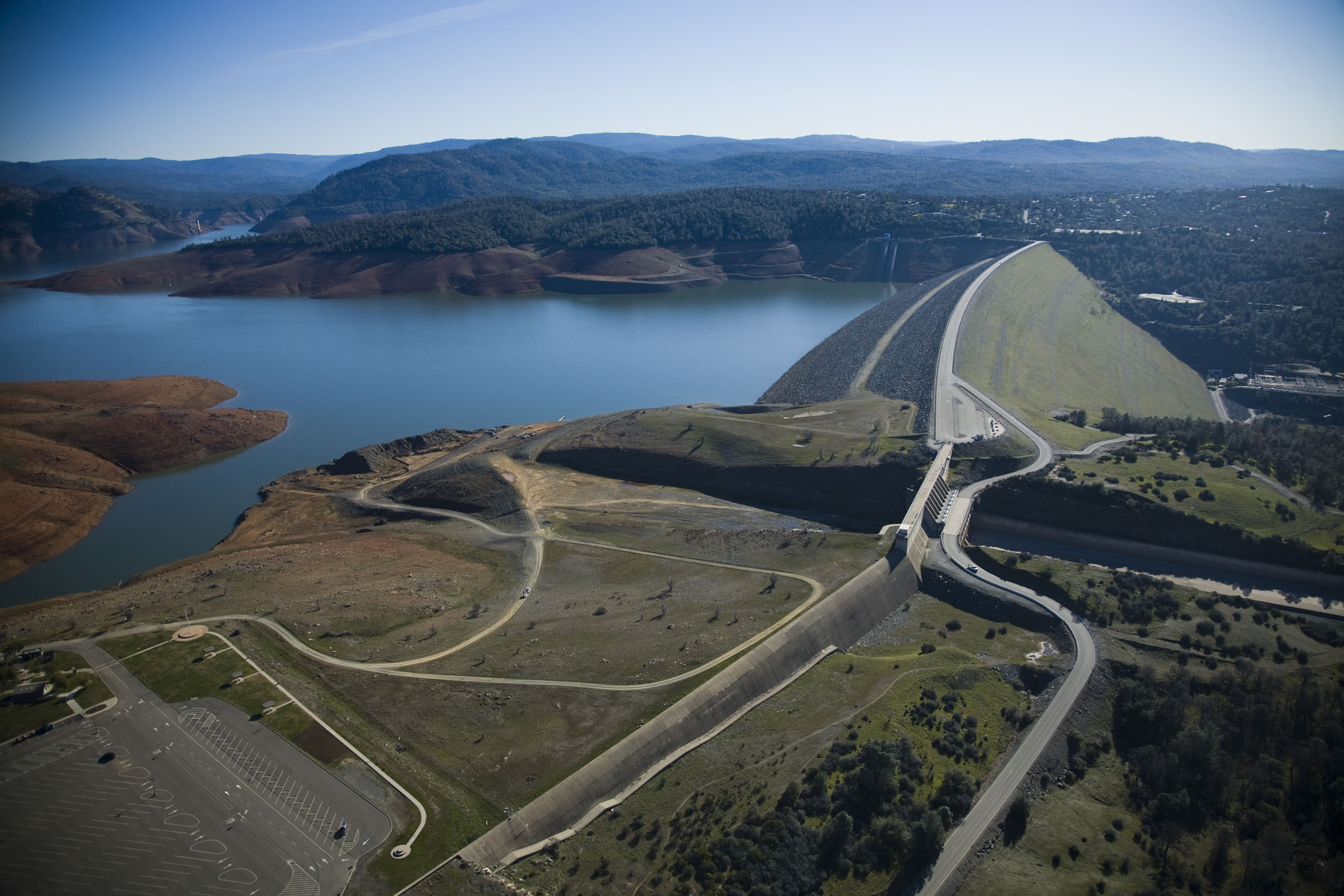
Here are two pictures of the New Bullards Dam and Spillway. It is about 20 miles away and opened in 1969. You can see that the water after leaving the concrete portion of the spillway has eroded down to bedrock and created a stable fan shaped path to the river below. It is my guess/hope that this is what the main spillway at Oroville will stabilize to.
well the media didnt ask them eitherPerhaps they should take media communication classes.
") but yes it all seems to be very coordinated and moving along.
but yes it all seems to be very coordinated and moving along.i thought it was horrible information wise. but we know the 'hole' is near the spillway. still dont know what they are planning on doing about it and when.
One out standing question that I have is why the auxiliary spillway has concrete coping for only the lateral 2/3rds, but not on the section closest to the main spillway? It seems that the area that didn't have the coping has sustained the most erosion.
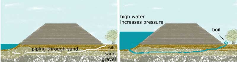
Good example, Mick, especially since I do some whitewater paddling myself (in canoes). I could see that the deeper holes had been cut by that very process. Anyway, I thought the terminology was worth mentioning since yet another poster mentioned that one of the more common causes of levee failure is "boils", in that case, being exactly the process I described, not that which you believe was actually meant in this case.
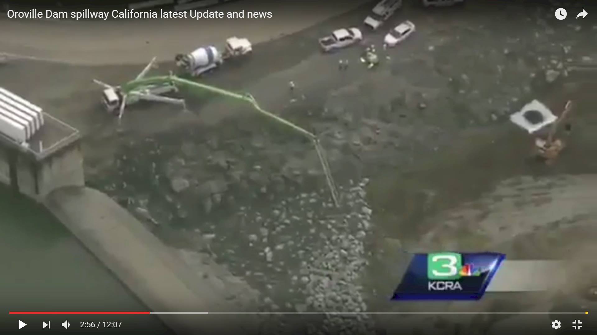
thank you i didnt see that, and didnt look for footage as i assumed media copters would have to stay away with all the helicopter work going on. will go check it now.The helicopter flyaround throughout the press conference was really helpful in this regard. There is a hole beneath the auxiliary spillway and one could already see that the top part has started being filled with rocks.
It seems like the 50 foot drop is wishful thinking. The storage at 50 feet from the spillway top, or 851 ft, is about 2,822,000 AF. That is 646,000 AF lower than the current level. If the storm comes in as expected, there is at most 60 hours before the flow starts ramping up, which would mean net outflows of 10,767 AF/hour or 130,277 cfsSheriff:
- Goal is to drop 50 feet before next storm
- Evacuation still in place, and they don't know when it will end
- Working on a "repopulation plan" to get people back in homes.
External Quote:Problem Oroville dam by poor maintenance
4 hours ago
The problems with the Oroville Dam in California are not so much caused by the heavy rainfall on maintenance. That says Piet Dircke of consulting and engineering company Arcadis.
The Dutch company has since 2010 engaged in the development of a "Delta Plan" for the triangle San Francisco-Sacramento-Stockton and familiar with the local situation.
According Dircke dam would never be able to succumb by abundant rain. Because there were suddenly holes in the 'spillway' (spillway), the structure in order to prevent critical water heights, there is a danger for the threatened area downstream direction Sacramento. ,, The spillway to drain water had already checked have to be replaced ten years ago. That has not happened by budgetary problems, '' said Dircke.
,, That the water level in the reservoir drops now is important, but it also hurts California. Climate change is much too dry in summer. Every drop of water is needed. '' Dircke said there are about 4,000 dams in the US, mostly between fifty and a hundred years old. The much needed maintenance requires billions. ,, It fits in improving the infrastructure that will Trump. ''
i think she means why are there no concrete blocks against the 'weir' near the main spillway, and why no fill in there. so the water doesnt fall as far over the lip.The auxiliary/emergency spillway doesn't have any concrete below the smooth concrete lip and its foundation. The water flows smoothly over the top of that wall, flows down the face, hits rock at the bottom and flows across the hillside's dirt and rock (and trees and bushes and earthworms). There is nothing added to keep it from the main spillway because there's a ridge of rock between the two spillways.
Yes, my point exactly, even if I might have been more descriptive than necessary (I have a tendency to be thorough).Levee boils (a very different thing to a whitewater boil) are a cause of failure of levees,
But that's obviously not happening here. Otherwise the emergency spillway would have failed by now.
Pictures are helpful thereYes, my point exactly, even if I might have been more descriptive than necessary (I have a tendency to be thorough).
There is already at least a 300 foot waterfall, and it is going to only get worse. The force of the water falling before it hits really increases the damage it will do.
The farther it moves up, the farther the water is going to fall, causing an increase in the speed of undercutting of the cliff face.
It's hard to tell, but it might be a 400 foot fall now. In any case, that seems to be the most pressing danger to the reservoir. The dam might hold, but if that cuts back to the actual reservoir, it's all over.
The rock of that mountain is metamorphic and mostly igneous in origin. Metamorphic means it's been altered, so it's not like the solid mass of rock as you imagine for Rio's Sugar Loaf. At least it's not a conglomerate, so it is not necessarily made of glued-together bits. However, it has been described as a "hard" rock. And it's up to 1500 yards deep, while the reservoir is only 300 yards deep.
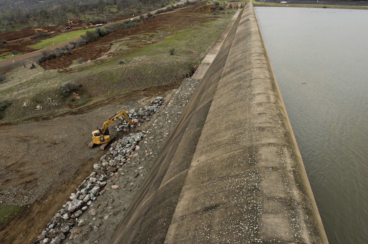
TOTAL guess here... im thinking its like a rain gutter, designed to move the water (although i cant really envision how it would, towards the pit because the pit is where the overflow tube is installed that goes under the road?I'm speaking of the concrete coping that abutts the bottom of the concrete rollover of the auxiliary spillway that can be seen pictured here. There is a small portion to the right closest to the main spillway with what looks like erosive damage even prior to this event (according to this google earth image) and that seems to be the area that sustained the most damage (the hole or boil depending on what people are calling it. I think of a boil as a continuously upwelling that would still be ongoing, but I could see how the rafting definition could confuse the semantics).View attachment 24545
Current damage vs. original damage. It has gone up the hill about 300 feet in six days (mostly with lower flow).
Is there a system like that in place? I could see that if there was. It would also make sense with the topography, but it wouldn't necessarily make sense in terms of protecting the main spillway, as it angles towards it.TOTAL guess here... im thinking its like a rain gutter, designed to move the water (although i cant really envision how it would, towards the pit because the pit is where the overflow tube is installed that goes under the road?
View attachment 24546
I'm speaking of the concrete coping that abutts the bottom of the concrete rollover of the auxiliary spillway that can be seen pictured here. There is a small portion to the right closest to the main spillway with what looks like erosive damage even prior to this event (according to this google earth image) and that seems to be the area that sustained the most damage (the hole or boil depending on what people are calling it. I think of a boil as a continuously upwelling that would still be ongoing, but I could see how the rafting definition could confuse the semantics).View attachment 24545
the red arrow in my pic is actually a flowing water stream from an overflow tube under the road. as far as if the 'rain gutter' theory is correct, i have no idea. They are saying the side of the main spillway there is solid bedrock, so it kinda is protected from pools i'm thinking.Is there a system like that in place?
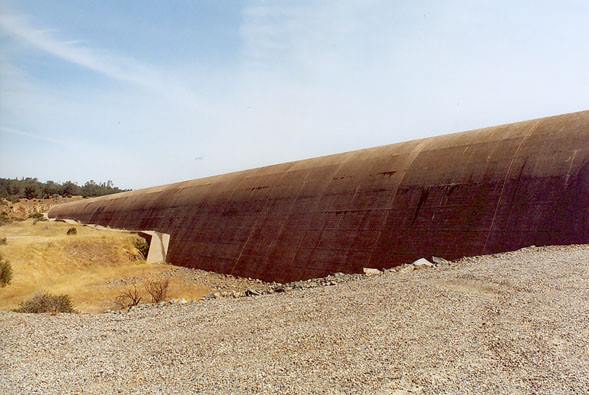
For what it's worth here's what it looked like when the lake was lower. It just looks like a retaining wall.
Perhaps it was never meant to stand up to being topped for days on end and the original designers knew it would blow out. Perhaps it's better just to think of the whole area as the emergency spillway. Just a sacrifice zone to protect the dam proper in the last extreme.
i think she means why are there no concrete blocks against the 'weir' near the main spillway, and why no fill in there. so the water doesnt fall as far over the lip.
View attachment 24541

I would question that logic only because we've already seen holes eroded 20 to 30 feet deep, even within roughly 50 to 60 feet of the base of that spillway. You could be right, in the event that the spillway structure is actually embedded that deeply (or more) within the ground, but based on the presence of that little deflection lip along the "left" three-quarters or so of the structure, I tend to think it's not founded that deeply. In addition, the way in which that deflection lip rises and dips according to the existing grade is almost a sure sign that the spillway is founded just below the existing grade. Had they founded it deeper, backfill along the bottom side would have been placed to a more constant elevation and the deflection lip would be level, or at least having constant slope.... This overflow is so far below the top of the dam that it was expected to be able to handle several feet of water over the top. That's a lot of force. The only reason for there to not be any spillway built at the bottom of that vertical concrete wall would be because what we see is expected to be able to handle that force..
The spot you speak of looks to me like it could possibly be a remnant of the original topography of the valley wall. Note that in light of Vicky's comments below, you can see that a much larger area along the natural flow path looks like original topography from before the time the dam was built. If not that, it could be intentional landscaping for funneling the flow of water toward that side (note that the roadway tends to make that happen, and surely the designers knew it at the time), and though that seems like a bad idea when considering the severe flow already seen here, perhaps they never expected the spillway to be over-topped by more than an inch or two. It has been mentioned numerous places that the emergency spillway has never been over-topped before, so I'm sure what's seen in that image is not post-construction erosion.
not with that amount of water coming. they get washed away then jam up the river.I had a question; why did they cut down all the trees? Don't trees help with reducing erosion on hills?
My understanding is that the trees likely would have ended up in the river downstream, complicating the danger of already-high water.Hello all,
As everyone else has said, thank you very much for the facts and information; this is very amazing.
I had a question; why did they cut down all the trees? Don't trees help with reducing erosion on hills?
Thanks,
Justin
I thought it best to add something to my previous reply. You imply that whatever the elevation difference is between the top of the primary dam and the top of the emergency spillway must be the equal to the depth (thickness) of flowing water over that spillway lip that the engineers were expecting. That's almost certainly not the case. Much of the strength of the soil structure within the dam itself comes about due to the confining force exerted by the weight of the fill above. At most elevations within the dam, that happens automatically, but at the very top of the dam, there is no such confining force because there is no additional material above that point. Thus, I would expect the portion of the dam which matches the highest design water level to have a substantial thickness of fill above it, contributing to the necessary strength of that material. Providing several feet of fill above the maximum waterline would only make sense, and I think it very unlikely that the design maximum pool elevation was intended to be near that of the top of the dam itself. That's just my logic and experience, but I could be wrong. This is an idea which could easily be checked, if one knew where to look.This overflow is so far below the top of the dam that it was expected to be able to handle several feet of water over the top.

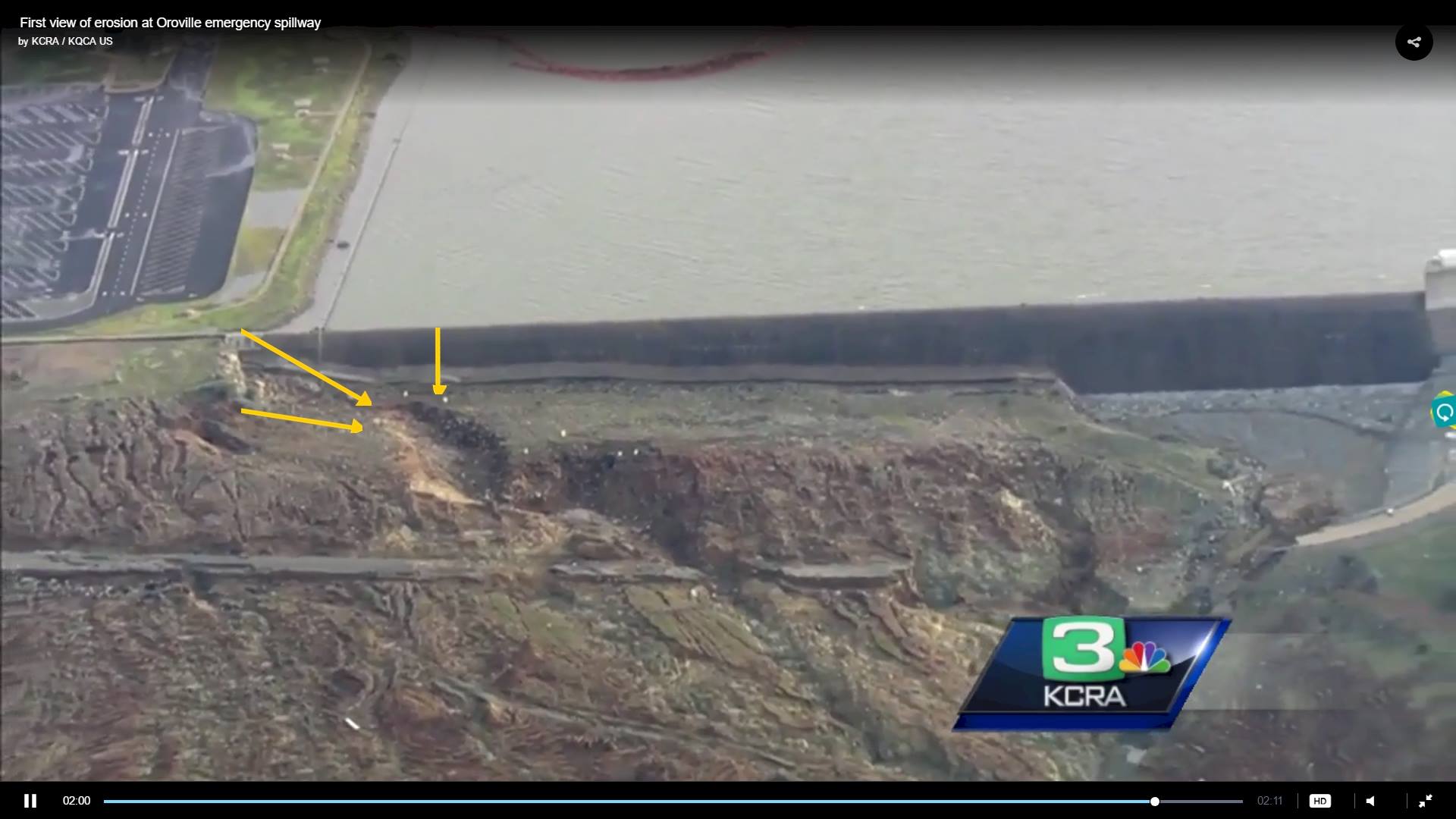
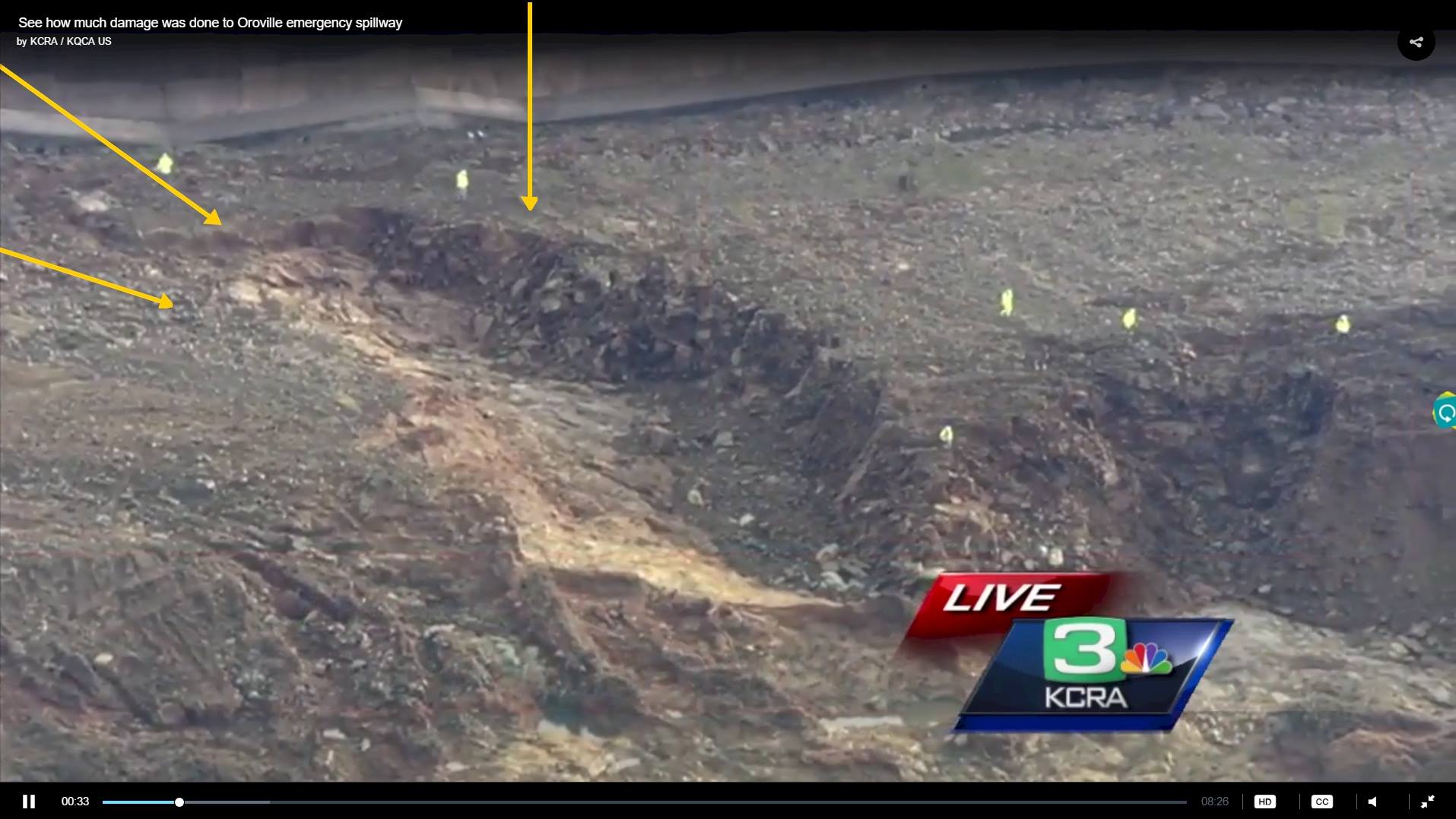
Image of the hole.
View attachment 24548
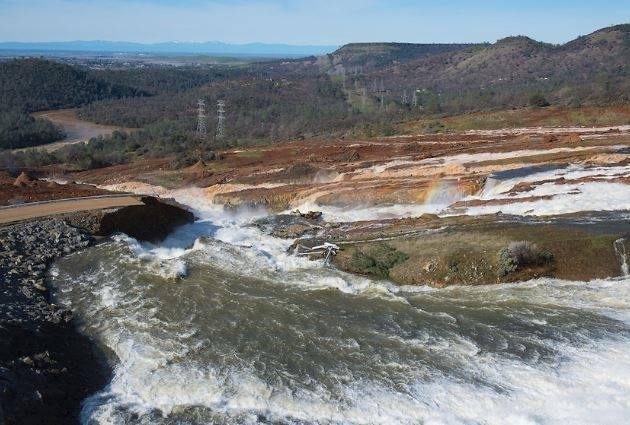
Image of the hole.
View attachment 24548