Oroville Dam Spillway Failure

Status
Not open for further replies.
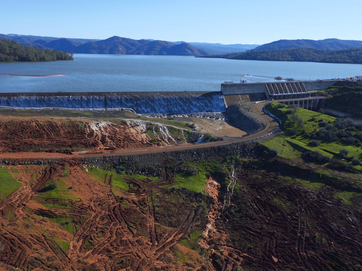
901.09 feet right now!!

Articles in which the emergency spillway is mentioned as some sort of "choice" are frustrating. It seems as though this safety feature is going to be breached this morning.

What about the ecological damage? The mud, rock, rebar, cement downstream.
 
Articles in which the emergency spillway is mentioned as some sort of "choice" are frustrating. It seems as though this safety feature is going to be breached this morning.

It was a choice (and still is). They could easily have opened the gates more to put 100K cfs down the main spillway. But they have to weigh erosion at the top and hillside vs. erosion at the bottom. They ramped down the main spillway flow as the erosion was going to take out some power lines.
 
20170211-082549-w1ey5.jpg

Time for a live test of something that was built 40 years ago, and has never been used, and is holding back a mountain of water. The Army Corps of Engineers says it's good for a massive flood of 700K cfs. But there's a lot of unknowns.
 
It was a choice (and still is). They could easily have opened the gates more to put 100K cfs down the main spillway. But they have to weigh erosion at the top and hillside vs. erosion at the bottom. They ramped down the main spillway flow as the erosion was going to take out some power lines.

Yes, of course. Insomuch as a safety feature is a "choice" after the preferred choice has been lost. You do think they could have easily allowed that amount of water down the main spillway? At some point this season they will be doing exactly that. It's going to be amazing to see the extent of the breakage of the spillway since the latest releases.
 
Yes, of course. Insomuch as a safety feature is a "choice" after the preferred choice has been lost.

The main spillway isn't "lost". The top half is still working perfectly.

Still, it wasn't exactly a choice to use the emergency spillway. They chose to gamble on the the inflow falling and the 65K outflow being maintained. They had to reduce to 55K, and the inflow decline leveled off a bit.

At some point this season they will be doing exactly that. It's going to be amazing to see the extent of the breakage of the spillway since the latest releases.

Yeah, the next storm systems are going to be scarey. They will have to continue to draw down the level as much as possible with the main spillway - probably for weeks. They might stop it briefly for inspections once the emergency spillway stops running.

Interesting times at Oroville and the Yuba area.
 
I appreciate you posting the KCRA footage. INSANE stuff, really. We are not getting that on a local level. I hope someone is out there with cameras.

Interesting times at Oroville and the Yuba area.

For those of us who hike the point regularly, it's concerning. Access to that trailhead....the emergency spillway catch basin will begin to spill over the road.
 
For those of us who hike the point regularly, it's concerning. Access to that trailhead....the emergency spillway catch basin will begin to spill over the road.

I think that road is likely going to be washed away. You've still got 90K cfs coming in, 55K going down the main spillway. That leaves 35K. That's still largely going towards raising the level of the lake, hence the minimal flow. But the higher the lake goes, the faster the overflow. I think it's going to ramp up very quickly and you'll start to see a torrent cutting up the hillside some time this morning.

09:00 level is 901.24 feet. There's probably some weir-related math to calculate the CFS given the length of a weir and height of the water level above the weir.

Note the weir also extends into the parking lot, all the way along to the hillside. Not clear what the slope up is though.
 
From the KCRA footage at around 0900hrs it looks like they reduced the regular spillway output. It doesn't look like the same flow as yesterday.
 
I think that road is likely going to be washed away. You've still got 90K cfs coming in, 55K going down the main spillway. That leaves 35K. That's still largely going towards raising the level of the lake, hence the minimal flow. But the higher the lake goes, the faster the overflow. I think it's going to ramp up very quickly and you'll start to see a torrent cutting up the hillside some time this morning.

09:00 level is 901.24 feet. There's probably some weir-related math to calculate the CFS given the length of a weir and height of the water level above the weir.

Note the weir also extends into the parking lot, all the way along to the hillside. Not clear what the slope up is though.

Does approaching velocity apply to this? Or is the damaged spillway going to be used to counter?
 
From the KCRA footage at around 0900hrs it looks like they reduced the regular spillway output. It doesn't look like the same flow as yesterday.

They just reduced it from 65K to 55K cfs. Still that an extra 75,000 gallons per second that is now heading for the emergency spillway.

(1 cubic foot = 7.5 gallons)
 
Does approaching velocity apply to this? Or is the damaged spillway going to be used to counter?

Approaching velocity of what? The water in the lake by the dam and spillway is essentially static. It's being filled up by rivers that are miles away.
 
View from the top:
Parking Lot Flooding-aw.jpg

The emergency spillway goes all the way along the edge of this parking lot. The lot itself is filling up via the drains that normally take rainwater to the lake. They are flowing backwards now.

The edges of these puddles will give a good indication of the changes in the lake level.

via:

Source: https://www.youtube.com/watch?v=RpTSUHDM2JQ
 
Here is an estimated rating curve for the spillway. It is only an estimate because I do not know if the elevation of the spillway along the parking lot has the same top elevation as the ogee crest spillway. I have used a weir coefficient (C, not to be confused with discharge coefficient Cd) of 3.0 as a compromise between that of an ogee crest (up to 3.8) and the parking lot (broad crest - roughly 2.0). The weir equation is Flow in cfs = C x length x (depth over spillway crest ^ 1.5). Length and depth are in feet. The horizontal scale is the height of the reservoir surface above the spillway crest.

Oroville Spillway Rating.jpg
 
From the posting immediately prior to my posting of the estimated rating curve, it appears that the weir crest adjacent to the parking lot is slightly higher in elevation than the ogee weir crest. As such the estimated rating curve may overestimate flow slightly.
 
Here is an estimated rating curve for the spillway. It is only an estimate because I do not know if the elevation of the spillway along the parking lot has the same top elevation as the ogee crest spillway. I have used a weir coefficient (C, not to be confused with discharge coefficient Cd) of 3.0 as a compromise between that of an ogee crest (up to 3.8) and the parking lot (broad crest - roughly 2.0). The weir equation is Flow in cfs = C x length x (depth over spillway crest ^ 1.5). Length and depth are in feet. The horizontal scale is the height of the reservoir surface above the spillway crest.

Oroville Spillway Rating.jpg

So does that mean if the net inflow is sustained at 35K cfs, then the level will rise to ~3 feet above the spillway?
 
I'm fascinated by this in spite of myself.

I can't imagine being one of the CWA engineers right now, seeing all my work literally washing away in front of me, nor can I really envision the effort it will take to rebuild in between wet seasons.

Despite all that it's such an awesome sight I just have to keep watching.
 
Weir coefficient and discharge coefficient are not the same. The weir coefficient is roughly equal to the discharge coefficient times the square root of 2g (two times gravitational force). Therefore the weir coefficient corresponding to a discharge coefficient of 0.62 (a high discharge coefficient for deep submergence that we will not see in this case) will be 0.62 x sqrt(2 x 32.2) or 4.9.
 
The empirical simplified formula for flow over a horizontal weir is Q (cfs) =3.33 * L * H^(1.5). (cite USBR).
Q = cfs
L = length in feet
H = head over the weir
where H/P <0.33 (P = depth of pool immediately behind the weir)
It appears the Oroville weir has a vertical wall, so P is greater than H.

L is conditioned on the upstream channel (usually cited as B). In the case of Oroville, there no restriction on the upstream channel.

Current head is 0.38 feet, so current flow over the 900 foot segment of the overflow operating is about 720 CFS.
The current imbalance is 24,000 cfs, so the lake elevation will build. (delta in the last hour was 0.15 feet).
 
Looks like it's using existing drainage under the road. The road is probably not long for this world though. It's just compacted fill, like the dam
I meant the two largely parallel channels downhill from the road, on the right. Probably only a foot deep right now.
 
It seems they have accepted that the main spillway structure below the initial damage, is a total loss, and large water release will not impact the structural integrity of the main dam.


According to the gentleman below (vid), there are 3 immediate concerns.
1) Erosion up above the initial main spillway damage, where there is a power-line tower that could be threatened,which supplies grid power to the plant/dam (see #3).
2) Debris build-up at the base of the damaged spillway, clogging the river, causing "backflow" into the dam's power-house....flooding it.
3) Maintaining power "to" the plant, so that excess water releases can be controlled and maintained.

Future concerns are:
1) A wet forecast in the next 4-5 days. (or even more wet weather after that)
2) Considerations of Spring snow-melt, as the snowpack is very high. (likely not enough time to repair the main spillway before that happens)

[video since r emoved from youtube]
 
Last edited by a moderator:
I've been trying to find video footage of the overflow from the emergency spillway, but the first hits on YouTube turned out to be the following channels (I am quoting here from their about pages, which make their intent quite clear.)

James Munder: TruEarther & Researcher

[
Social Commentary on Relevant Issues Such as CERN, Space, Technology, News, Politics, Religion, The Internet, Sports, Art, People, & Things Affecting Us All.

Introducing My Weekly Show "What Do You Think?" Spotlighting Interesting Topics. I Think The Best Way To Learn Is To Listen. A Place To Learn, Grow & Laugh. I Want To Know What You Think. Contact Me:

<Email Address Removed> In Subject Line Put: Name - Guest Host
To Be On The Show You Will Need A Google+ & YouTube Account. Thank You, James Munder From The Research Revolution
Content from External Source
https://www.youtube.com/user/1Munder1/about

Higher Truth Channel


A group of concerned individuals from various parts of the world. Backgrounds in Geology, Physics, Astronomy, Medicine. We aren't experts per se but we are educated at the Collegiate Level.

This channel is meant to be provocative in content. It is meant to cause you to think and ponder.

We have correctly predicted countless monster flares, predicted that China would stop loaning us money, End of Iraq War, Identified Periods of Increased Seismic Events, Reported on Destruction of comet Elenin before it was official. We have predicted strings of earthquakes and swarms, even calling out exact location and magnitudes at times. We made a series of predictions two years ago. A list of earthquake and flare predictions. We stated we would take down this channel if all of the predictions did not come to fruition by first week in March 2014. We nailed every single prediction. Then came "The Nibiru Test" Predictions... Again! So Specific and Detailed! Nailed It!

THE SKY DON'T LIE!
Content from External Source
https://www.youtube.com/user/Bpeirce2/about

Quite simply the conspiracy peddlers and fear mongers have latched onto this major media event and are adding their own 'spin' to it so as to entertain the rubes and thanks to search engine optimisation they are drowning out the major news organizations.
 
Quite simply the conspiracy peddlers and fear mongers have latched onto this major media event and are adding their own 'spin' to it so as to entertain the rubes and thanks to search engine optimisation they are drowning out the major news organizations.

I have been slightly surprised by the lack of major news organizations covering this. Not even to mention the abysmal coverage by local news. (I'm local.) KCRA out of Sacramento has been doing a decent job, plus they have a bird or a plane which makes for video footage. Why doesn't someone send a drone up?

The presser has been one of the more interesting updates thus far. Dismayed to hear that they are considering an alternative placement of the spillway. I really think that rec area is going to be closed for some time.

There is so much engineering and math...and this forum has been the ONLY place I've found where the failure and responses are being discussed informationally.
 
In the video from DWR press conference, did you guys understand his answer to the question (at about 27:56 in the video) about why inflows minus primary spillway outflows would not equal outflows over the emergency spillway? He didn't really explain it well ("engineers get paid a lot of money to figure this out" does not demonstrate a deep grasp of the issue) and it seemed to contradict what folks on this board were saying. Thanks.


[video added.. this version question is at 31:30]

Source: https://www.youtube.com/watch?v=wF-0bPO1CGs
 
Last edited by a moderator:
Here's some HD drone footage of the spillway, yesterday (2/10)


I have been slightly surprised by the lack of major news organizations covering this.
I agree....I haven't seen one mention of this in my local news, or National TV news coverage. Maybe I missed it ???

Trump 'news' is trumping a lot of important local, national, and international news and events.
 
In the video from DWR press conference, did you guys understand his answer to the question (at about 27:56 in the video) about why inflows minus primary spillway outflows would not equal outflows over the emergency spillway? He didn't really explain it well ("engineers get paid a lot of money to figure this out" does not demonstrate a deep grasp of the issue) and it seemed to contradict what folks on this board were saying. Thanks.

It's like a wave effect....or that inflow 2 miles away will not immediately affect the outflow....it takes some time for the inflow to reach the outflow, miles away.
 
Status
Not open for further replies.
Back
Top