Debunked: RADAR proves no curve!

William W

New Member
Thread Summary
The original claim was that radar signals do not bend. Subsequent investigation showed that they do bend due to atmospheric refraction, which allows them to detect targets beyond the geometric horizon, see, for example:
http://msi.nga.mil/MSISiteContent/StaticFiles/NAV_PUBS/APN/Chapt-13.pdf
If the radar waves traveled in straight lines, the distance to the radar horizon would be dependent only on the power output of the transmitter and the height of the antenna. In other words, the distance to the radar horizon would be the same as that of the geometrical horizon for the antenna height. However, atmospheric density gradients bend radar rays as they travel to and from a target. This bending is called refraction.
Content from External Source
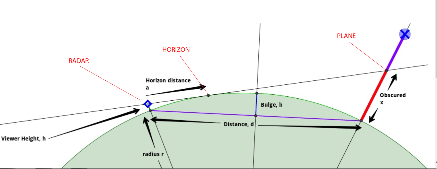
Additionally the mounted height of the radar must be taken into account.
See also:
https://en.wikipedia.org/wiki/Radar_horizon


As a former US Navy radar tech/operator I know for a fact radar signals do not bend but yet radar can detect targets well beyond the supposed horizon.

I am talking commercial radars not military OTH radar which supposedly bounces the beam off the ionosphere.

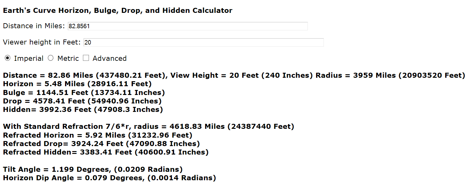
Check the specs on a commercial radar, for this example I am using the Garmin Fantom 4 radar. Garmin specs indicate targets can be detected out to 72 miles. At that distance the drop according to metabunk is over 3000 feet. So it is impossible if there is a drop because radar works off of line of sight. The beam in this case according to Garmin is 1.8 degrees. The rf energy beam goes straight out hits the target and bounces straight back to the antenna.

There are commercial radars that their specs state the radar can detect targets as far away as 177 miles away. The drop according to metabunk is nearly 4 miles. So it would be impossible!!!!

https://buy.garmin.com/en-US/US/p/533660
 
Last edited by a moderator:
Garmin specs indicate targets can be detected out to 72 miles.
There are commercial radars that their specs state the radar can detect targets as far away as 177 miles away.
This means that maximum effective distance of the radar signal, before it starts to act wonky and/or stop detecting things well, is 72 (or 177) miles, so the Garmin won't be able to detect e.g. a plane that's 100 miles away. It's not a promise that everything within a 72 (or 177) mile radius is within the radar's line of sight; a small hill would disprove that notion.
 
This means that maximum effective distance of the radar signal, before it starts to act wonky and/or stop detecting things well, is 72 (or 177) miles, so the Garmin won't be able to detect e.g. a plane that's 100 miles away. It's not a promise that everything within a 72 (or 177) mile radius is within the radar's line of sight; a small hill would disprove that notion.
So 72 miles is true? So that proves no curve. Thank you.
 
So 72 miles is true? So that proves no curve. Thank you.
actually the Garmin thing says 72 nautical miles, but as a Navy guy you should know the difference.


How far do you need to see?
This question, how much range you want from a radar, involves a couple of factors and some trade-offs. First, there’s the factor of height. Your radar can’t see over the earth’s curved horizon, so the height of your unit above the ocean surface, and the height of the target you’re looking at limit how far away you can identify objects.

For the techies among us, here is a simple formula: (1.22 nautical miles x square root of height of radar) + (1.22 nautical miles x square root height of target) In simple English, that means that if your boat has an antenna on a T-top that’s nine feet off the water, and you’re searching on the screen for a boat that’s the same size, you’ll need to be within 7.3 nautical miles (1.22 x 3 + 1.22 x 3 = 7.32). That’s the best-case scenario, but since fiberglass isn’t a very good radar reflecting material, you might have to be a lot nearer before you see the other boat.
https://www.westmarine.com/WestAdvisor/Selecting-Marine-Radar
Content from External Source
I use radar a lot, being from Maine, and probably have well over 2000+ hours, perhaps more, (was a commercial fisherman for about 8 years in my younger days) and literally thousands of miles of time spent in the fog with radar. My suggestion is quite the opposite of dogs. Get the dome on the mast and get it high. http://www.sailnet.com/forums/gener...-how-far-can-your-radar-really-see-marpa.html
Content from External Source
 
Last edited:
So 72 miles is true? So that proves no curve. Thank you.
I think you misunderstood (whether on purpose or not I am not sure)
Bfahome said it means it can detect something 72 miles away line of sight , So if your radar is on a boat, it can detect a plane 72 miles away flying at 27,000ft (5 miles above the Earth ) for example
 
If the Earth was flat and there was no horizon, why would you need to invent an Over The Horizon Radar that bounces signals off the ionosphere?
 
As a radar operator you should know about the various modes of anomalous propagation. In weather radar, AP can cause ground clutter at distances (and therefore heights) at which a beam should encounter no obstacles. Radar is EM waves, which refract like all other forms of light and do not follow straight paths in the atmosphere. Any proof of FE relying on light's path must take this into account.

Many FE theories actually use refraction as an excuse as to why the earth seems to curve, in fact.
 
The radar's line of sight is called "Radar horizon" and as a military guy, you should have heard about that before. There's a Wikipedia article on that topic.


Dh is the distance from your position to the radar horizon (or in other words: the point where the radar shadow begins).
H is your height above sea level.
Re is the radius of the earth (approx 6.4·10³km).
 
actually the Garmin thing says 72 nautical miles, but as a Navy guy you should know the difference.


How far do you need to see?
This question, how much range you want from a radar, involves a couple of factors and some trade-offs. First, there’s the factor of height. Your radar can’t see over the earth’s curved horizon, so the height of your unit above the ocean surface, and the height of the target you’re looking at limit how far away you can identify objects.

For the techies among us, here is a simple formula: (1.22 nautical miles x square root of height of radar) + (1.22 nautical miles x square root height of target) In simple English, that means that if your boat has an antenna on a T-top that’s nine feet off the water, and you’re searching on the screen for a boat that’s the same size, you’ll need to be within 7.3 nautical miles (1.22 x 3 + 1.22 x 3 = 7.32). That’s the best-case scenario, but since fiberglass isn’t a very good radar reflecting material, you might have to be a lot nearer before you see the other boat.
https://www.westmarine.com/WestAdvisor/Selecting-Marine-Radar
Content from External Source
I use radar a lot, being from Maine, and probably have well over 2000+ hours, perhaps more, (was a commercial fisherman for about 8 years in my younger days) and literally thousands of miles of time spent in the fog with radar. My suggestion is quite the opposite of dogs. Get the dome on the mast and get it high. http://www.sailnet.com/forums/gener...-how-far-can-your-radar-really-see-marpa.html
Content from External Source
I sense ignoring what my point is vs. tech talk, and yes it was nautical miles, picky picky, the math still doesnt work. Plug the numbers into the metabunk calculator and the target would not be able to be detected but yet it is. Don't need to get technical trying to ignore the facts: no radar at 15 feet above the water according to the calculator could see a target 20 miles away or 30 or 40 or 50 or 60 or 70 miles away. Thank you.
Honest question. Is this a dark government site? Will men in black suits come see me now?
 
I sense ignoring what my point is vs. tech talk
sorry. you said you were a radar tech. figured you would appreciate tech talk*.

the point is the Gamin range does not prove 'no curvature' because the range is dependant to where it is mounted on the boat, according to the expert boat men. If i am mistaken in believing them, you can give me evidence they are wrong. I did read all the pages on your Gamin link, dont think i missed anything that would disprove the calculator.

Will men in black suits come see me now
being female, i going to suggest it should be 'people in black' :)

and no this is not a government site.


*i'm not sure quoting boat forums could be considered 'tech talk'. Youre on a site that has some mega nerd members... if you want real tech read some other threads.
 
no radar at 15 feet above the water according to the calculator could see a target 20 miles away or 30 or 40 or 50 or 60 or 70 miles away
do you have any proof that any radar mounted at 15 feet anywhere ever saw another boat at 70 miles away? or 50? or 30?

or proof that anyone ever claimed it did?
 
no radar at 15 feet above the water according to the calculator could see a target 20 miles away or 30 or 40 or 50 or 60 or 70 miles away.
Oh yes it can, but not on the earth surface, but that is also not what Garmin is claiming.
Do you really don't want to see / understand the difference?
 
Don't need to get technical trying to ignore the facts: no radar at 15 feet above the water according to the calculator could see a target 20 miles away or 30 or 40 or 50 or 60 or 70 miles away.
And no radar buried ten feet underground could see a target anywhere.

Imagine a flashlight that's advertised as able to be seen from a mile away. You and a friend stand a mile apart across an open field and your friend shines the flashlight at you. You are able to see the light across the field, because you are within the claimed range and there is nothing blocking the light. Now if your friend puts their hand or a bag or some other essentially opaque object over the light, you won't be able to see the light anymore. There is now an obstruction between you and the flashlight, so the claimed range no longer applies.

So when the Garmin radar says its range is 72 miles, it does not mean that everything within 72 miles is guaranteed to be within the radar's line of sight; it means that, when something is within line of sight of the radar, the radar can reliably detect it up to 72 miles away. If it moves further away then the signal is no longer reliable, and if it becomes obstructed then the radar will no longer be able to detect it. If you've mounted your radar in such a way that the curvature of the Earth significantly obstructs its line of sight to the object you're trying to detect, the radar will not be able to detect that object, even if it is within the claimed 72 mile range. This is not a flaw in its design, and it is not false advertising; unless Garmin claims the radar can see through objects like a small hill, the curve of the Earth, or the hole I've put your radar in, those would be considered obstructions and would nullify the range claims, like with the flashlight example above.
 
If you've mounted your radar in such a way that the curvature of the Earth significantly obstructs its line of sight to the object you're trying to detect, the radar will not be able to detect that object, even if it is within the claimed 72 mile range.
Thats why in the early days of radar, around the first few years of WW2, when both the British and German forces were building networks of radar stations along both sides of the English Channel, pilots on both sides took to crossing the channel at very low altitudes to 'hide' behind the curvature of the earth, hence the term 'flying below the radar'
 
Thats why in the early days of radar, around the first few years of WW2, when both the British and German forces were building networks of radar stations along both sides of the English Channel, pilots on both sides took to crossing the channel at very low altitudes to 'hide' behind the curvature of the earth, hence the term 'flying below the radar'
and once missile technology caught up and Mach 3 Capable bombers would still not outrun the radar or the missiles, strategy switched to low level to reduce the speed of detection, as immortalized in the Sinclair Spectrum Game Tornado Low Level:

NOT ACTUAL GAME FOOTAGE.
 
To sum up: The 72 nautical miles is a technical specification for that particular unit. How strong it is. It doesn't mean it can always see 72 miles. That depends on if anything gets in the way. So mount your radar up high; which everyone always does.

Think of an old fashioned lookout using a searchlight at night. You would put both up on a mast. Right? And which searchlight would you use? One that advertises one mile maximum range or one that advertises three miles maximum range? The three mile maximum range thing is just a technical spec for the unit. It doesn't mean the horizon is three miles away.
 
Is a line of sight of 72 miles on a sphere earth credible? How high would an airplane have to be to see it at 72 nautical miles?

The Metabunk Calculator uses statute miles so let's convert 72 nautical miles to statute miles.

https://www.google.com/webhp?source...rt+nautical+miles+to+statute+miles+calculator

72 nautical miles = 82.8561 statute miles


Let's put the radar unit on a 20 foot mast.


A plane at 3992 feet altitude would be right on the horizon. So a plane at say 5,000 feet would be well above the horizon. You might wish for a more expensive radar unit that can see more than 72 nautical miles. (We won't complicate things with atmospheric effects.)


People often don't think about how the observer's height affects the situation. Forget about "drop." The important thing is obscured height. Here's what the situation looks like:

 
Last edited:
I was a career merchant marine officer for 20 years. Everyday I was on the bridge of a ship in front of at least 2 radars. Our radar antennas were mounted on top of the bridge about 150 feet above the water line. typically you could see another large ship out to about 35 miles or so. If we were approaching Japan you might see Mt Fuji 70 miles away, but that's a big mountain. Our radars were designed to be surface search radars so planes generally were not looked at. One radar was an X-band radar and could see rain out at 50 miles. The curvature of the earth was the limiting factor for how far we could see. Yes, sometimes you could get some ducting, but that was rare.
 
I find this an interesting discussion as I am interested in the flat earth model. WiliMREO, you mentioned that a radar antenna mounted at 150 feet could see another large ship at 35 miles or so. Checking the earth curvature calculator (https://dizzib.github.io/earth/curve-calc/?d0=35&h0=150&unit=imperial) , I plugged in 150 feet for height and 35 miles distance and got a curvature of 266 feet (meaning the earth's curvature would hide the lower 266 feet of an object at the distance). Are these large ships you speak of taller than 266 feet? If not, how could the radar pick them up?
 
I find this an interesting discussion as I am interested in the flat earth model. WiliMREO, you mentioned that a radar antenna mounted at 150 feet could see another large ship at 35 miles or so. Checking the earth curvature calculator (https://dizzib.github.io/earth/curve-calc/?d0=35&h0=150&unit=imperial) , I plugged in 150 feet for height and 35 miles distance and got a curvature of 266 feet (meaning the earth's curvature would hide the lower 266 feet of an object at the distance). Are these large ships you speak of taller than 266 feet? If not, how could the radar pick them up?
As discussed earlier, the radar horizon calculation is not the pure geometric line-of-sight calculation. Try this calculator, which gives about 35 miles for two ships with radar at 150 feet.
http://members.home.nl/7seas/radcalc.htmMetabunk 2019-12-29 14-28-49.jpg
 
And no radar buried ten feet underground could see a target anywhere.

Imagine a flashlight that's advertised as able to be seen from a mile away. You and a friend stand a mile apart across an open field and your friend shines the flashlight at you. You are able to see the light across the field, because you are within the claimed range and there is nothing blocking the light. Now if your friend puts their hand or a bag or some other essentially opaque object over the light, you won't be able to see the light anymore. There is now an obstruction between you and the flashlight, so the claimed range no longer applies.

So when the Garmin radar says its range is 72 miles, it does not mean that everything within 72 miles is guaranteed to be within the radar's line of sight; it means that, when something is within line of sight of the radar, the radar can reliably detect it up to 72 miles away. If it moves further away then the signal is no longer reliable, and if it becomes obstructed then the radar will no longer be able to detect it. If you've mounted your radar in such a way that the curvature of the Earth significantly obstructs its line of sight to the object you're trying to detect, the radar will not be able to detect that object, even if it is within the claimed 72 mile range. This is not a flaw in its design, and it is not false advertising; unless Garmin claims the radar can see through objects like a small hill, the curve of the Earth, or the hole I've put your radar in, those would be considered obstructions and would nullify the range claims, like with the flashlight example above.

No one is saying you can see anything if it's obstructed (or underground, whoever said that, SMH).
What is clear are the specs... 72mi unobstructed.

So a plane at 72mi...no problem.
A ship at 72mi...no problem

Yet that would negate the curve.
Curved ocean, under the model we are told is true would mathematically yield the following:
72mi distant -> Below the curve 3,456ft

Please confirm.
 
Last edited by a moderator:
So a plane at 72mi...no problem.
A ship at 72mi...no problem

Yet that would negate the curve.
Curved ocean, under the model we are told is true would mathematically yield the following:
72mi distant -> Below the curve 3,456ft

What does "below the curve" mean here? If the surface of the ocean is curved, then how and anything be "below" it (and not be underwater)?

Can you draw a diagram illustrating what you think the problem is? Don't post again without a diagram.
 
On a purely procedural point why would the world’s military spend billions on AWACS/AEW/AEW&C aircraft with downward looking RADAR if the earth was flat? Three aircraft can cover the whole of Central Europe, which three ground-based RADARs cannot. Probably why they have names like Sentry, Hawkeye, Nimrod and Globaleye.

And why would military naval forces use fixed wing and rotary aircraft for RADAR picket duty. Perhaps sailors know more about the shape of the Earth than the OP does.

Conversely, why would nominal attacking aircraft use tactics like nap-of-the-earth and terrain masking if not for the Earth’s curvature (and geography) offering them protection against detection.
 
What does "below the curve" mean here? If the surface of the ocean is curved, then how and anything be "below" it (and not be underwater)?

Can you draw a diagram illustrating what you think the problem is? Don't post again without a diagram.

curve diag 72mi.jpg
curve calc 72mi.jpg
 
Last edited by a moderator:
I don't see where anybody uses the 4/3 Earth model for radar range. Earth does not look like 6371 KM radius to a microwave signal, but 3/4 of that.
Your source contradicts that claim.
Article:
image.jpeg
image.jpeg

k=1 or "geometric" refers to modeling Earth with a 6378 km radius; k=4/3=1.33 refers to modeling Earth with a k*6378km radius for the purpose of determing the correct angles.

The quoted graphs show that atmospheric refraction is correctly modeled with a k between 1 and 4/3; near the surface, close to 4/3 is better, near 100 000 ft close to 1 is better. (This makes sense because there is hardly any atmosphere at that altitude, which means there is hardly any atmospheric refraction.)

Using a model of Earth that assumes a k=3/4 radius is always worse than simply using its actual radius (k=1), because the correct value is between 1 and 4/3, and 3/4 is outside that range (3/4 < 1).

tl;dr if the microwave signal "thinks" it is running straight, then Earth looks bigger to it than it actually is, because atmospheric refraction bends it towards the Earth.
 
Last edited:
Your source contradicts that claim.

That's because I'm a dyslexic idiot and really meant 4/3. So the Earth looks flatter than it is, and radar goes further.
There's other conditions that impact radar range, like ducting which can be extreme over warm water. But it's rare, and comes and goes. But the main determinant of radar range is a set of variables that you can plug into the Radar Range Equation (good entry on Wikipedia) which takes into account transmit power, antenna gain, noise figure, wavelength, target size, and the like. Note that some terms are interdependent, like antenna aperture, wavelength, and gain. Range is very important because of the inverse square law of radiation, which gets you coming AND going, so double the range needs 4 times the transmit power, or antenna gain/size, or something.

Radar requires transmitting lots of power (kilowatts or megawatts) and getting microwatts back. This makes it susceptible to interference from other radars and jamming. If Earth was flat, other radars would be continually jamming each other. Same thing with broadcasting stations on the VHF and up bands. Let Flatheads try to explain their way out of that.
 
Back
Top