Time lapse Mamatus Undulatus forming?

Balance

Senior Member.
It's been very humid in the UK recently, yesterday being very noticeable at ground level at least - felt like a steam sauna in the morning when walking the dog. In the afternoon, though I regret not being able to film it, saw a full aerodynamic contrail coming off an airliner I wasn't able to confidently ID on FR24 after the event, though suspect it was the one transcending through FL290 (1am UTC over Hants/Dorset border).

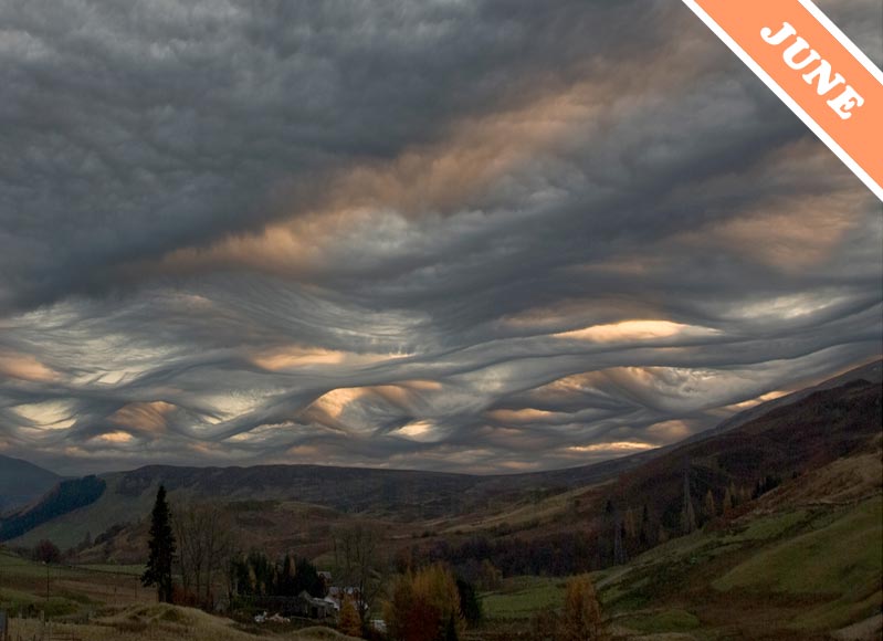
Driving out of the New Forest today, it looked like Mamatus Undulatus was forming and managed to find a layby to pull into and capture this timelapse (zipped vid and screengrab attached) which also illustrates the higher cloud layers being blown in a different direction to the underlying layers.
MamUn.JPG
 

Attachments

  • 00615.zip
    37.3 MB · Views: 854
The still image in your post looks like "asperatus" .

My computer refused to extract the mpeg from the zip so I can see the timelapse. I bet it is very interesting based on your description and that still image.
 
The still image in your post looks like "asperatus" .

My computer refused to extract the mpeg from the zip so I can see the timelapse. I bet it is very interesting based on your description and that still image.

You're probably right of my mis-identifying, my cloud knowledge is novice-level, if that.
Sorry the compressed file won't unzip properly either, not sure what went wrong, I used 7-zip.

Interestingly since, the local sky looks exactly the same. It has not evolved at all, just lovely wavy underlines.
 
Looks like something brewing up there. May I ask what kind of camera you used? (Looks like JVC, just like mine...)
 
The still image in your post looks like "asperatus" .
Interesting information on this type of cloud from Wikipedia:

Asperitas (formerly known as Undulatus asperatus) is a cloud formation, proposed in 2009 as a separate cloud classification by the founder of the Cloud Appreciation Society. If successful it will be the first cloud formation added since cirrus intortus in 1951 to the International Cloud Atlas of the World Meteorological Organization.[2] The name translates approximately as "roughness".[3]
Content from External Source
And from the Cloud Appreciation Society

JUNE 2009


A NEW CLOUD NAME?
A few years back, we chose a Cloud of the Month which we didn’t feel very confident about identifying. Since it looks rather like the surface of a choppy sea viewed from below, we gave it the nickname of the ‘Jacques Cousteau cloud’, after the legendary 1970s French diver and ecologist.

But as we started receiving more and more dramatic examples of this cloud formation from members and visitors across the world, we decided that it warranted a more official-sounding name. We looked for a Latin one that would sound at home amongst the official cloud classifications and settled on ‘asperatus’, which is the Latin for ‘roughened up’. The term was used by Classical poets to describe the seas being agitated by strong winds.

We propose that asperatus should be adopted as a new ‘variety’ of cloud, meaning that it is a particular characteristic that appears in one or other of the main cloud types. This would mean that the rough and choppy looking Altocumulus cloud shown above would become known as ‘undulatus asperatus’.

Our proposed new cloud variety shares some similarities with existing formations such as the more regular waves of undulatus clouds and the hanging pouches of mamma clouds, but we feel that this cloud is different enough from them to be classified as a variety of its own – or a ‘supplementary feature’, if you want to be precise about it.

Who knows whether asperatus will eventually be accepted as an official variety? If it ever is, we will celebrate with a snorkelling holiday.

Asperatus over Schiehallion, Perthshire, Scotland © Ken Prior


Content from External Source
 
Seems I wasn't the only one to notice and capture the sky yesterday. It made local newspaper. http://www.bournemouthecho.co.uk/news/14609302.PICTURES__Strange_cloud_formations_seen_over_Dorset/

RESIDENTS have taken to social media about strange-looking clouds across Dorset.

The unique formation, known as Undulatus asperatus, was spotted over Castlepoint, Winton, at Bournemouth beach and thinning at Poole Quay.

Proposed in 2009 as a separate classification by the founder of the Cloud Appreciation Society, the name translates roughly to roughened or agitated waves.

A sea in the air then.

Although they appear dark and storm-like, they tend to dissipate without a storm following. They are often seen in the Plains of the US, during the morning or midday hours following thunderstorm activity.
Content from External Source
 
The still image in your post looks like "asperatus" .

My computer refused to extract the mpeg from the zip so I can see the timelapse. I bet it is very interesting based on your description and that still image.

Sorry for the late reply but I totally forgot my cam's standard format is AVCHD (?.MTS) which I should have converted to .MP4 before zipping. (Corrected with new attached)
 

Attachments

  • My Movie.zip
    14.8 MB · Views: 732
Update:


Things are looking up for cloudspotters.

After eight years of lobbying by the Cloud Appreciation Society (CAS), the chaotic, dramatic asperitas formation will be included in the new edition of the World Meteorological Organisation's (WMO) definitive guide to the skies — the International Cloud Atlas.
Content from External Source
http://www.abc.net.au/news/2017-03-...lassified-meteorological-organisation/8376340

And apparently it is not alone

In addition, the new atlas puts forward five "special clouds" with tongue twisting names like "cataractagenitus," "flammagenitus," "homogenitus" and "silvagenitus." These clouds are created by localized factors such as large waterfalls, heat from wildfires and engine exhaust from high-flying aircraft, which are also known as contrails.
Content from External Source
http://mashable.com/2017/03/21/cloud-atlas-new-types-asperitas/#11KE4ivhmmqX
 
Back
Top